Radford Semele Neighbourhood Plan - Regulation 16 Submission
(8) 6.0 Neighbourhood Plan Policies
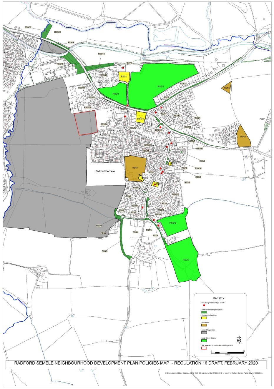
6.1 This section sets out the planning policies of the Regulation 16 Draft RSNDP. These policies will be used to help determine planning applications in the area and so shape the future of Radford Semele as an enjoyable place to live and work in, and visit. The policies have been prepared by the Steering Group on behalf of the Parish Council. The policies should be read in conjunction with the accompanying Policies Maps.
The policies set out in the RSNP are as follows:
|
Securing a Suitable Mix of Housing Types, Tenures and Sizes in New Developments. |
|
|
Local Green Spaces |
|
|
Protecting Small Open Spaces |
|
|
Sport and Recreation Facilities |
|
|
Protection of Community Facilities |
|
|
Conserving and Enhancing Radford Semele's Landscape Character |
|
|
Non-designated Heritage Assets |
|
|
Footpaths |
|
|
Cycling |
|
|
Traffic Management and Public Transport |
|
|
Community |
|
|
Area of Separation |
|
|
Local Economy |
Policy Map 1. Radford Semele Neighbourhood Development Plan Policies Map (OS Licence Number 100059565)
OBJECTIVE 1: To ensure that the future mix and type of housing meets the needs of those living in the area.
(8) Policy RS1– Securing a Suitable Mix of Housing Types, Tenures and Sizes in New Developments.
In meeting District-wide planning policies H2 and H4, development proposals for new housing should also be informed by and demonstrate how they have met local housing needs based on up to date information, including local housing needs identified in the Parish Housing Needs Survey.
Applicants proposing new homes must show how they have considered and responded to guidance provided through the WDC Residential Design Guide, Secured by Design (SBD) and the Lifetime Homes Standard. New housing must seek to meet WDC's Climate Emergency commitments.
Infill and the creation of multiple dwellings from a single dwelling will only be supported where there is a need for housing and it is compliant with Housing Policy H1.
Background/Justification to Policy RS1
6.2 Local Plan Strategic Policy DS2[7]: Providing the Homes the District Needs seeks to ensure that Warwick district's housing needs are met. Similarly, the Parish Council wishes to see local needs met, particularly for those who wish to downsize and those who wish to access their first home. In line with Policy DS2 development should provide a mix of new homes to meet different needs.
6.3 Policy H4 of the Local Plan "Securing a Mix of Housing" sets out policy for securing a mix of housing on development sites:
"The Council will require proposals for residential development to include a mix of market housing which contributes towards a balance of house types and sizes across the district including the housing needs of different age groups, in accordance with the latest Strategic Housing Market Assessment [SHMA]."
6.4 Policy H2 Affordable Housing of the Local Plan sets district wide affordable housing policy, that states:
"Residential development on sites of 11 or more dwellings or where the combined gross floor space is more than 1,000 sq. m will not be permitted unless provision is made for 40% affordable housing."
6.5 In June 2019 WDC unanimously agreed to declare a 'Climate Emergency'. WDC passed a motion to facilitate decarbonisation by local businesses, other organisations and residents so that total carbon emissions within Warwick District are as close to zero as possible by 2030. WDC also accepted an invitation to take part in the internationally recognised UN programme "One Carbon World". WDC will be the first council to become carbon neutral through this scheme, achieving internationally recognised UN Climate Neutral Status. To ensure WDC meets its new commitments and targets any new developments and new businesses should be considered in view of a "Climate Emergency". New developments should include innovative ways to reduce carbon emissions, such as solar with storage or air/ground sourced heating, or other renewable options.
6.6 A Housing Needs Survey was undertaken by WDC in June 2017. This survey concluded that Radford Semele had the following identified housing needs:
|
Housing association shared ownership: |
1 x 2 bed house |
|
Housing association rented: |
2 x 2 bed house 1 x 3 bed house 1 x 4 bed house |
|
Owner occupied: |
1 x 1 bed bungalow 1 x 2 bed house |
This requirement has already been met and exceeded by recent housing developments.
6.7 All future planning applications should consider local evidence of housing needs as well as the SHMA produced by Warwick District. This will help to ensure new development is more responsive to the needs of people in the neighbourhood area. Policy RS1 should, therefore, be read in conjunction with Local Plan Policies H2 and H4.
6.8 As the neighbourhood area's population and age profile changes, it is important to ensure that new housing development is accessible to all. To ensure that this is the case all new homes should be designed to the principles set out in the WDC Residential Design Guide, Secure by Design and the Lifetime Homes Standard. Lifetime Homes are ordinary homes designed to incorporate the design criteria that can be universally applied to new homes at minimal cost. Each design feature adds to the comfort and convenience of the home and supports the changing needs of individuals and families at different stages of life. Secured By Design is a police organisation that seeks to achieve sustainable reductions in crime by embedding crime prevention in the design and planning process.
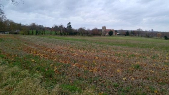
OBJECTIVE 2: To protect and enhance local green spaces
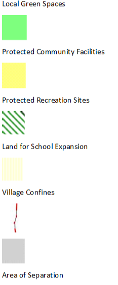
(19) Policy RS2 – Local Green Spaces
The green spaces below and shown on the Policy Map 2 are designated as local green spaces:
RS2/1 – Church Fields West & East
RS2/2 – Leigh Foss
RS2/3 – Angley Hole and Woods
Development proposals affecting the designated Local Green Spaces will be assessed against national Green Belt policy.
The Local Green Space Assessments details are given in Appendix 1
Policy Map 2. Designated Local Green Spaces (OS Licence Number 100059565)
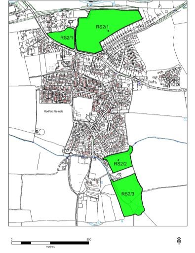
(9) Policy RS3 – Protecting Small Open Spaces
Development that would result in the loss of the other small, open spaces including those listed in Appendix 2 and shown on Policy Map 3 will only be supported when:
- Equivalent or better provision is provided elsewhere within a suitable location in Radford Semele village; or
- It can be clearly demonstrated that the open space performs no useful function.
Policy Map 3. Protected Small Open Spaces (OS Licence Number 100059565)
Background/Justification to Policies RS2 and RS3
6.9 NDPs allow communities to designate and protect Local Green Spaces - green areas of particular importance to them. To be designated a Local Green Space such spaces must meet criteria in national planning policy.
6.10 Policy RS2 identifies three Local Green Spaces. Appendix 1 outlines the analysis criteria as set out in the NPPF and Appendix 1, Table A1 sets out how each of the Local Green Spaces meet the NPPF designation criteria. These spaces have also been identified following feedback from two village consultations.
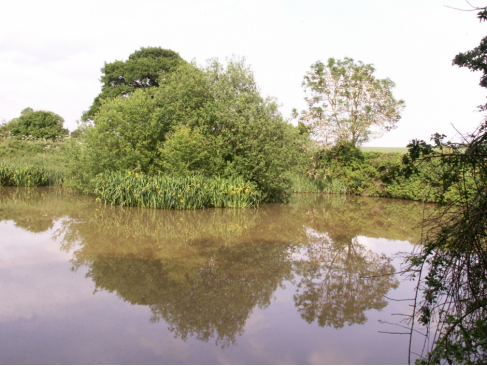
Figure 13- Turkey Pool in Angley Hole Local Green Space
6.11 As well as the "demonstrably special" Local Green Spaces, the village also has some smaller, sometimes incidental open spaces, such as grass verges. Whilst not meriting the protection of designated local green spaces, these Smaller Open Spaces still play an important role in maintaining the village's quality of life by providing visually attractive areas, breaks from built development and areas for people to pass the time of day. The analysis of the role and function of these spaces is set out in Appendix 2.
OBJECTIVE 3: To protect and support improvements to community facilities
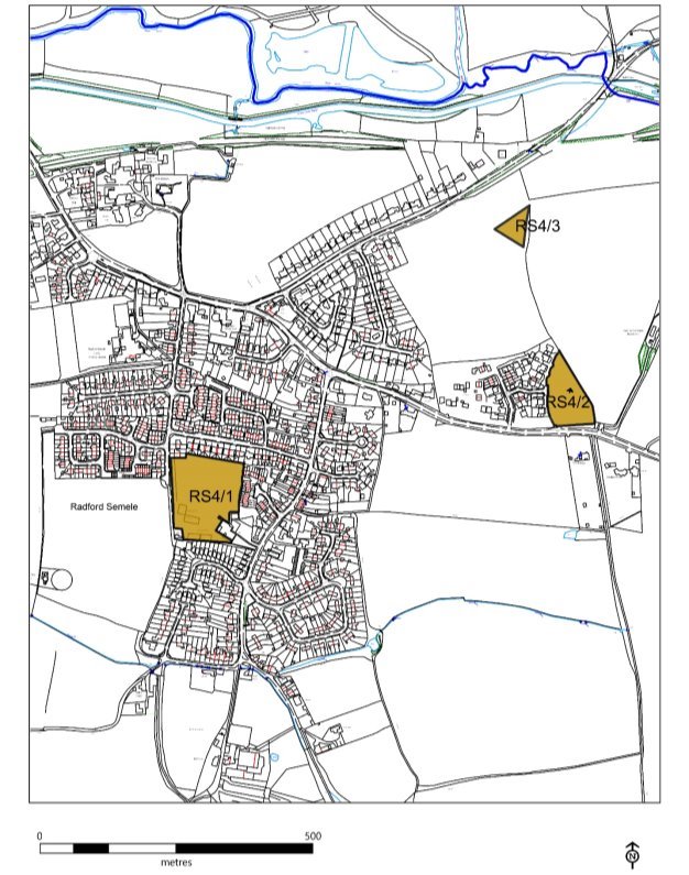
(5) Policy RS4 – Sport and Recreation Facilities
The following recreation facilities also identified on the Policies Map (Policy Map 4) will be protected in accordance with Local Plan Policy HS2 – Protecting Open Space, Sport and Recreation Facilities:
RS4/1 - Village Playing Field/Recreation Ground
RS4/2 - Semele Park South, recreation and children's playing area
RS4/3 – Future Semele Park North, recreation and children's playing area
Development proposals for the improvement of the existing recreation facilities on these sites will be supported when they would not have a significant adverse impact on residential amenity. If new leisure, sport and recreation are created during the lifetime of the NDP they will be protected by Policy RS4.
Development proposals that would result in the loss of these facilities will only be supported when the applicant can demonstrate that the facility is no longer needed for recreational use or suitable alternative provision can be provided elsewhere within the neighbourhood area, to an equivalent or better standard, and in a location that is in close proximity to the community it serves.
Policy Map 4. Sports and Recreation Facilities
(OS Licence Number 100059565)
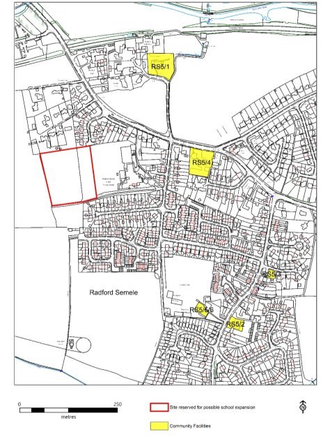
(9) Policy RS5 – Protection of Community Facilities
There will be a presumption in favour of the protection of existing facilities in accordance with Local Plan Policy HS8. Where permission is required, the change of use of local community facilities, as listed below, will only be permitted for other health, education or community type uses (such as village halls, local clubhouses, health centres, schools and children's day nurseries), unless one of the following can be demonstrated:
- The proposal includes alternative provision, on a site within the locality, of equivalent or enhanced facilities. Such sites should be accessible by public transport, walking and cycling and have adequate car parking; or
- Satisfactory evidence is produced (including active marketing locally and in the wider area) that, over a minimum period of 12 months, it has been demonstrated that there is no longer a demand for the facility.
The facilities are listed as follows and shown on the Policies Map.
RS5/1 - Parish Church of St Nicholas
RS5/2 - Baptist Church
RS5/3 - Village shops, including Post Office
RS5/4 - White Lion Public House
RS5/5 - Community Hall
RS5/6 - Sports and Social Club
RS5/7 - Radford Semele Church of England Primary School
Proposals that would enhance the appearance, improve access and accessibility to these facilities will be supported when they are in accordance with other development plan policies and the policies of RSNDP.
Suitable proposals for a future expansion of the Primary School would be supported.
Any new Community Facilities adopted during the lifetime of this NDP will be protected under RS5.
Policy Map 5. Community Facilities (OS Licence Number 100059565)
Background/Justification to Policies RS4 and RS5
6.12 Community,sport and recreation facilities are the essential glue that help bind a community together. They provide important services, places for people to meet, form relationships and to enjoy sports, games and other pastimes that contribute to individual's and the community's health and well-being.
6.13 National planning policy acknowledges that the planning system can "promote social interaction, including opportunities for meetings between people who might not otherwise come into contact with each other" (NPPF, paragraph 91a). Warwick District Local Plan planning policy seeks to promote healthy, safe and inclusive communities (Policy HS1), protect open space, sport and recreation facilities (Policy HS2), and protect community facilities (Policy HS8).
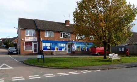
Figure 14- Village Store & Post Office and Community space
6.14 In line with this national and development plan policy framework the RSNDP identifies those sport and recreation and community facilities that should be protected in the neighbourhood area. These facilities include:
- Village Store & Post Office and Hair Salon provide a range of grocery provisions, DVDs, cash facilities, wines, spirits and soft drinks. The Post Office counter service was transferred to the shop on the retirement of the previous sub-postmaster. These are widely used and allow many people to transact their business within the village. Magazine and newspaper sales, including a delivery service used throughout the village, have also been transferred to the shop. It is a focal point for informal meetings during the day as people move about the village. Next to the village store is a hair salon.
- The Community Hall is available for hire seven days a week at reasonable hourly rates. It was fully refurbished in 2005. The hall has a stage facility and seating for approximately 120 people. Contained within the building are the footballers' changing room facilities, kitchen and meeting room. These were fully refurbished in 2014.The Community Hall was also decorated throughout in 2016 and grants obtained to fund new lighting and sound equipment.
-
The Playing Field used for football and other recreation.The maintenance of the playing field is a Parish Council responsibility. The responsibilities include grass cutting, hedges and trees maintenance, provision and maintenance of children's play equipment, footpath safety, providing dog and waste bins, litter clearance and public liability insurance.
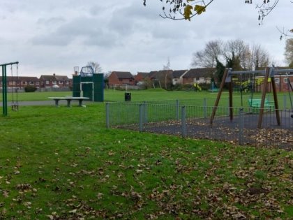
Figure 15 - Radford Semele recreation ground, well-used by all age groups
The children's play area is very small, providing limited space for the growing population. Children's play equipment for all age groups, including skateboard ramps and a basketball court, are provided and maintained by the Parish Council. A substantial part of the grassed area is allocated to the football pitch used by one children's team and two adult teams. All teams have use of the now refurbished shower/changing rooms within the Community Hall. The community has expressed a wish for the space to include a pavilion, a cricket pitch for summer use and a tennis court. If funding and space is available these aspirations will be considered. The Parish Council has also been asked to consider providing some pieces of adult exercise equipment and has recently replaced and refurbished the children's play equipment.
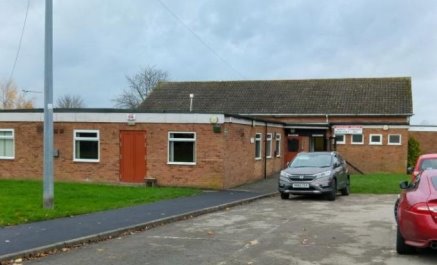
Figure 16 - Community Hall and Sports and Social Club
- The Sports and Social Club has operated as a membership run organisation since the combined Hall and Club was built in 1969. In addition to its very congenial bar facilities it provides high quality TV presentations of most national and international sporting events. The committee organises an extensive number of activities each year. Major events include an annual fun day on the playing field, numerous live music evenings and charity quiz nights.
- Radford Semele Church of England Primary School, locatedin School Lane, is a relatively small school providing education for one class per year between years Reception to Year 6. In total the school has a capacity for about 200 children. The school provides a first-class standard of primary education and has been classified by Ofsted as "Good"[8]. The school is much sought after by parents and is always close to full capacity.
The school has a restricted potential for growth beyond its current capacity, being limited by the poor sewerage disposal infrastructure and lack of available land for new classrooms. Proposals for the future expansion of the Primary School using the land marked on Policy Map 5 so that it can cater for all primary age school children in the village who wish to attend their local school will be supported.
-
The village churches: St Nicholas Church located north of Southam Road from Church Lane, is a medieval church dating back to the Domesday Book. It is Grade II listed and was recently restored and refurbished. Radford Semele Baptist Church, a Victorian building located in Lewis Road opposite the Community Hall. Both churches have active communities and work closely together.
OBJECTIVE 4: Protecting Local Landscape and Heritage
(17) Policy RS6 - Conserving and Enhancing Radford Semele's Landscape Character (Details in Appendices,4, 5, 6 and 7)
Any new development must protect, conserve and enhance the area's landscape character by:
- protecting the historic character and settlement pattern of the area. Particularly the distinct settlement of Radford Semele, individual farmsteads and key heritage assets;
- retaining the network of water features of rivers, streams, ponds and canals;
- looking to open up any existing culverts on a site providing more open space/green infrastructure for greater amenity and biodiversity; and the creation of new culverts should be kept to a minimum. New culverts will need consent from the Lead Local Flood authority (LLFA) and should be kept to the minimum length.
- protecting the mosaic of woodland, trees and hedgerows;
- planting new hedgerows and improving redundant and gappy existing hedgerows;
-
by protecting the essential character and quality of the following views within the Parish of Radford Semele as shown on Policy Map 6:
RS6/1 – view east from Canal Bridge when entering Radford Semele from Leamington;
RS6/2 – view of Church and Church Fields from corner of A425/Offchurch Lane;
RS6/3 – view east looking from St Nicholas Graveyard;
RS6/4 – view looking east from corner of Semele Park development;
RS6/5 – view from footpath south of new Spring Lane development;
RS6/6 – view from Valley Woods looking south-east;
RS6/7 – view from Valley Road Looking south-east, and
RS6/8 – views from Crown Hill Trig Point.
- retaining and improving existing Public Rights of Way, and, where possible and feasible, creating new Public Rights of Way;
- screening urban forms of development and having appropriate transitions from urban to rural areas; and
- in appropriate locations, introduce new planting of coverts and tree belts to restore the Feldon Parklands character.
Background/Justification to Policy RS6
6.15 Natural England produces profiles for England's 159 National Character Areas (NCAs). These are areas that share similar landscape characteristics, and which follow natural lines in the landscape rather than administrative boundaries, making them a good decision-making framework for the natural environment.
6.16 NCA profiles are guidance documents which can help communities to inform their decision-making about the places that they live in and care for.
6.17 Each profile includes a description of the natural and cultural features that shape a landscape, how that landscape has changed over time, the current key drivers for ongoing change, and a broad analysis of each area's characteristics and ecosystem services. Statements of Environmental Opportunity (SEOs) are suggested, which draw on this integrated information. The SEOs offer guidance on the critical issues, which could help to achieve sustainable growth and a more secure environmental future.
Policy Map 6. Community Valued Views (OS Licence Number 100059565)
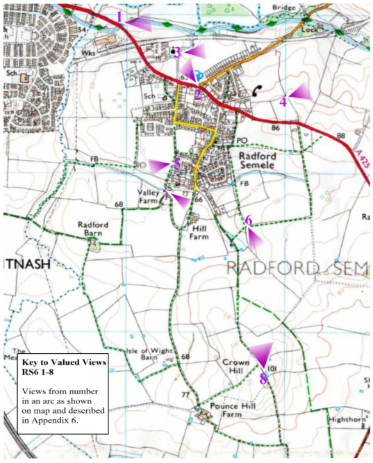
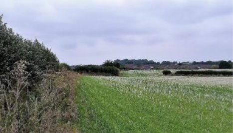
Figure 17- Example of Dunsmore and Feldon NCA
6.18 Radford Semele lies within NCA96: Dunsmore and Feldon[9]. Natural England's NCA work has been used to inform the development of Policy RS6:
"The Dunsmore and Feldon NCA is a predominantly rural, agricultural landscape, crossed by numerous small rivers and tributaries and varying between a more open character in the Feldon area and a wooded character in Dunsmore.
The name Feldon refers to the old English term feld meaning 'open cleared land' and expresses the contrast, in medieval times, with the more wooded Arden area to the north-west. The area is mainly within Warwickshire, with the southern boundary delineated by the steep limestone escarpment of the Cotswolds, and the northern boundary by the Leicestershire Vales. To the west lie the well-wooded pastures of Arden, together with the Severn and Avon Vales, while the undulating pastures and low hills of the Northamptonshire Uplands form the eastern border.
The NCA is an important food producing area and the agricultural expanse of large arable fields, improved pasture and small villages forms a transitional landscape between the surrounding National Character Areas (NCAs). The land to the north comprises the wedge-shaped area of low ridges and valleys lying between Leamington Spa, Coventry and Rugby, and is known as Dunsmore.
The historic character of this area is very important, in particular its ancient woodlands, enclosed fields, veteran trees, landscaped parklands and areas of archaeological interest, including deserted villages and numerous sites of remnant ridge and furrow.
The area is facing key challenges around how to protect and enhance its assets and recreational resource while accommodating the pressure for sustainable modern growth and development and the needs of the communities who live there.
The NCA includes 4 Statements of Environmental Opportunity (SEO) that may be relevant in the preparation of the NDP, in particular the development of any landscape related policies. These are:
SEO 1: Protect and appropriately manage the historic character, settlement pattern and features of Dunsmore and Feldon, in particular its areas of archaeological and heritage interest, including the deserted settlements and ridge-and-furrow sites, ancient woodlands, veteran trees, farmsteads, country houses and landscaped parklands, and enhance the educational, access and recreational experience for urban and rural communities.
SEO 2: Protect and appropriately manage Draycote Reservoir and the important network of natural and manmade rivers, streams, ponds, canals and other wetland habitats for their important role in water provision and water quality, for the species they support and for their contribution to recreation, sense of place and geodiversity.
SEO 3: Protect and manage the mosaic of habitats including woodlands, hedgerows and heathlands, particularly ancient and semi-natural woodlands, together with sustainable management of agricultural land, and new planting of woodland and heathland, where appropriate, to ensure continued provision of food, to extend the timber and biomass resource and to contribute to pollination, biodiversity and carbon storage, and for the benefits to soil and water management.
SEO 4: Protect and manage the landscape character, high tranquillity levels and the historic settlement character to enhance sense of place and of history and to promote recreational opportunities; and ensure that new development is sensitively located and designed, integrate green infrastructure links into development, encourage new woodland planting to soften urban fringe developments and promote recreational assets such as the National Cycle Routes."
6.19 In addition, to the NCA work at the wider landscape level, there has been supplemented by work at a more local level undertaken by Warwickshire County Council in their more detailed Landscape Study, that considered landscape at parish level. In this study the focus is on the characteristics that make this part of the Feldon Parklands Landscape Character Area.
6.20 The recent designation of a Conservation Area and the recently published draft Canal Development Plan Document give further planning protection for the part of the canal corridor which runs through Radford Semele Parish. Trees and woods in the Conservation Area benefit from the same level of protection as that that Tree Preservation Orders (TPO) confer.
6.21 At the consultation a high volume of comments from residents commented on the need to retain important iconic views both within the village and on the outskirts, but within the Parish boundary. These views were considered important because they reinforce Radford Semele's identity as a rural village by providing a visual connection with the village and the neighbouring countryside. The Neighbourhood Plan Steering Group undertook a survey of important local views. Eighteen views were initially assessed against landscape sensitivity, openness, importance of setting and community value using recognised national guidance from Historic England, Campaign for Rural England and national and local planning policy. Site visits were also undertaken to assess and record the potential views and spaces. They were presented for comment to the residents at the consultations, with many making formal or informal comments to the committee. The Senior Planning Officer (WDC) felt we needed to concentrate on the most important local views. From this initial list 8 key views were selected that the Steering Group felt representative and worthy of protection. We recognise that the quality of views is subjective (and not tangible in a land use sense) and one view considered important by one person may not be by another. Our policy RS6 therefore focuses on the views which are considered to be important to the community at large. Some were eliminated from consideration because the views extended beyond the parish boundary.
Figure 18- View of St Nicholas Church from Offchurch Lane
6.22 The views proposed by RS6 should be protected. They include views from the village of the surrounding countryside and views from within the wider countryside but contained within the Parish boundary. Appendix 6 includes a short description of each view and why they are considered to be important. Policy RS6 does not preclude development that may impact on these views; it seeks to ensure that such development takes place in such a way that the essential overall qualities of these open views are protected and retained.
6.23 Wildlife corridors, which include the Grand Union Canal, species-rich hedgerows, woods and streams, are essential to the biodiversity of the parish. The parish is bordered by streams and by the Grand Union Canal and River Leam. There are several ponds in the parish and these could be potentially improved as wildlife habitat.
6.24 The parish has an extensive network of hedges with a variety of landscape and wildlife value. As well as supporting populations of many common organisms; these rich habitats support populations of protected and rare species such as:
|
|
6.25 Existing hedgerows should be retained and their status should be improved wherever possible. Additional native trees and shrubs which provide food and shelter for wildlife have been planted by FoRGE to enhance verges and hedges and to increase the biodiversity of the recreation ground. Similar planting should continue where possible.
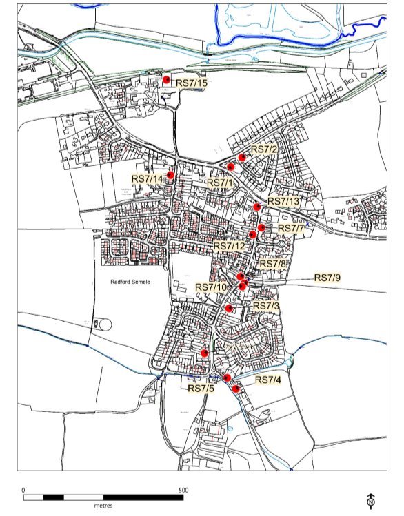
(6) Policy RS7 – Non-designated Heritage Assets
Development proposals affecting the significance of non-designated heritage assets will only be supported in the following circumstances:
- where renovation or alteration of non-designated heritage assets require planning permission, such changes are designed sensitively, and with careful regard to the heritage asset's local distinctiveness, historical and architectural value and pay appropriate regard to the asset's setting ensuring it maintains the historic rural character; or
- where a development proposal would result in the total loss of, or substantial harm to the significance of a non-designated heritage asset, such development will only be supported when the public benefit of the proposed development outweighs the total loss of or substantial harm to the significance of the asset and its setting. Where such development is permitted, this will be conditioned in such a way so as to ensure the proposed development takes place after any harm or loss has occurred and that appropriate recording of the heritage asset takes place prior to any loss or harm occurring.
This policy applies to the following sites and is also shown on the Policies Map:
|
RS7/1 |
- |
The Manor (Also known as The Gable End House) Corner of Offchurch Lane/Southam Road. |
|
RS7/2 |
- |
Manor Lodge, Offchurch Lane. |
|
RS7/3 |
- |
The Baptist Church, Lewis Road. |
|
RS7/4 |
- |
29 and 30 The Valley. |
|
RS7/5 |
- |
1-3 The Valley. |
|
RS7/6 |
- |
Site of Ancient Village Stocks. |
|
RS7/7 |
- |
Nos 5-15 Lewis Road. |
|
RS7/8 |
- |
No. 50 Lewis Road |
|
RS7/9 |
- |
Nos. 43-51 Lewis Rd. |
|
RS7/10 |
- |
Briar Cottage, No. 53 Lewis Rd. |
|
RS7/11 |
|
102 and 104 Lewis Road. |
|
RS7/12 |
- |
No. 20/22 Lewis Road. |
|
RS7/13 |
- |
The Old Bakery, No. 2 Lewis Road |
|
RS7/14 |
- |
The Elms, No. 6 School Lane |
|
RS7/15 |
- |
Original Barn building, Radford Hall Farm, Church Lane |
Policy Map 7. Non-Designated Heritage Assets (OS Licence Number 100059565)
Background/Justification to Policy RS7
6.26 As well as our Historic England designated heritage assets (Appendix 4) and WDC locally listed assets (Appendix 5) Radford Semele Parish community, during consultations, put forward a list of further heritage assets. From this long list, the Steering Group, has identified 15 sites which are identified in the RSNDP as non-designated heritage assets. The community has expressed a wish to protect these assets. These non-designated heritage assets are identified in Policy RS7 and the reasons for their inclusion are set out in Appendix 5. These sites will be protected in accordance with their significance and local distinctiveness.
6.27 In developing the list of locally important heritage assets the guidance issued by Historic England has been used This advice may be found on the Historic England website (https://www.historicengland.org.uk/images-books/publications/good-practice-local-heritage-listing/). The assessment of the assets listed in RS7 is given in Appendix 6.
6.28 Paragraph 197 of the NPPF sets out that where a planning application directly or indirectly affects a non-designated heritage asset, that the effect of that application on the significance of the non-designated heritage asset should be taken into account in determining the application. The principle to be applied in weighing applications is that "a balanced judgement will be required having regard to the scale of any harm or loss and the significance of the asset". The non-designated heritage assets would carry limited protection via Policy RS7, this is much less than a statutory protection (e.g. as would a listed building), nor are they protected through Policy HE3 Locally Listed Heritage Assets of the Local Plan.
OBJECTIVE 5: Minimise the impact of road traffic and improve opportunities for walking and cycling.
(16) Policy RS8 - Footpaths
Improvements to footpaths which enable safe access to the valued surrounding landscape for tranquil leisure walking for health and well-being will be encouraged and supported.
These improvements include the following:
- Installing a safe pedestrian crossing point to link the eastern side of the village, including the recent development at Semele Park, to the village centre and its facilities and to provide access to the bus service into Leamington. A possible site could be east of the Lewis Road, Southam Road junction, near to the bus stop.
- Footpaths and other pedestrian rights of way should allow unimpeded access to villagers of all levels of mobility. Within the neighbourhood area consideration should be given to make access easy for disabled people, pushchairs & wheelchairs.
-
Improvements to footpaths to provide better accessibility within the village and to improve access on foot to the wider countryside, including:
- linking existing footpaths to create a village circular walk;
- providing a footpath link between Semele Park and Canalside Community Food along the A425;
- providing a footpath link to the canal, Radford Bottom Lock, the Offchurch Greenway and Offchurch village;
- an improved footpath link to Leamington Spa;
- a new footbridge over Radford Brook to connect existing footpath to Whitnash Brook local nature reserve;
- a new footpath linking existing path W121 at rear of Williams Road with existing footpath W119b running to the north;
- footpath from The Valley through Leigh Foss to connect to existing footpath, and
- new access to the canal from the A425 for all users.
For further information see Appendix 7
Background/Justification to Policy RS8
6.29 Appendix 7 sets out the local network of footpaths, cycle routes and bridleways in the neighbourhood area. Despite these, the A425 has become a major barrier, dividing the village into two separate communities with very few ways for pedestrians and cyclists to safely cross between the two areas. This is an important issue because the main village facilities – shops, community centre, school and recreation field are south of the A425. However, the largest development of new homes (210 dwellings) and considerable number of homes built in the 50s and 60s are north of the A425; as are the church and access to the Grand Union Canal towpath.
6.30 The problem of a potentially divided community was one of the most frequent issues brought up during village consultations. There is only one pedestrian controlled crossing point on the A425 near the White Lion pub. This is now insufficient to accommodate the increase in population to the east of the village. Pedestrians wanting to use the village's key facilities have to take their life in their hands every time they cross the A425. There have been several accidents already, one of a serious nature. The community requested that to improve road safety an additional pedestrian crossing to the east of the village and traffic calming measures along the A425 should be installed.
6.31 The Semele Park development has only a narrow footpath, no safe pedestrian crossing points and no cycleways for residents to get to the school, Post Office, community hall, Parish and Baptist Churches, sports & social club or pub. There has recently been a traffic accident near it's exit on to the A425.
6.32 The village has a wide diversity of residents with differing levels of mobility. Safe access to footpaths and other rights of way should allow unimpeded access and where appropriate, suitable adjustments made to those routes to ensure this, e.g. pavement drop kerbs and clear ways to off road public footpaths.
6.33 The bus stop opposite Lewis Road has no safe crossing point to the main part of the village and school, Post Office, community hall, Baptist Church, social club or pub. For an illustration of the danger facing pedestrians, please refer to the photograph of a person with limited mobility, who has just alighted from the bus crossing the road in front of a car. Fast vehicles are a particular hazard for those using motorised wheelchairs to cross from Semele Park.
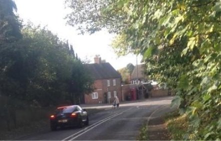
Figure 19- Example of a near miss of person with limited mobility crossing the main road with fast moving traffic.
6.34 In spite of 30 and 40 mph warning signs a large percentage of vehicles are speeding as they travel through Radford Semele from either direction, putting any pedestrians who have alighted from the bus from Leamington in great danger. It should be pointed out that a disproportionate number of vulnerable disabled and older people will be using the bus service, along with parents with young children and unaccompanied school children.
6.35 During consultations one of the most valued aspects of the village was found to be its proximity to green space with open views of the countryside. This is also very hard to access because of the main road and limited access to the Grand Union Canal. Within the village there is very limited green open space and it is clear that villagers greatly value access via the public footpath network to the surrounding countryside.
6.36 Canalside Community Food is a community supported agriculture project. As well as supplying vegetables and fruit to its members it supports a partner project for those with learning disabilities. It provides opportunities to learn about vegetable growing and attend farm-related social events and work parties. Events are open to all and are attended by Radford Semele residents. Although very close to the village it cannot be safely accessed on foot.
6.37 The Greenway (north of the old railway line), is part of the National Cycle Route 41, but cannot be safely accessed on foot or by cycle from the village. Safe access for children from the village on cycles currently entails a road trip with cycles on the rear of a vehicle.
6.38 Offchurch is our nearest village, but there is no footpath link to it from Radford. To walk to Offchurch directly, the only route is alongside a narrow and dangerous B-road, which has a 50mph speed limit.
6.39 The lack of a safe pedestrian route between the village and the canal at Radford Bottom Lock restricts access to the canal towpath and to the Offchurch Greenway both of which are valuable recreational and leisure facilities which also link with other recreational areas and routes. We would strongly support a safe pedestrian and cycling route which along with the proposed access to the canal from the A425 would enable more people, such as families with young children, to access these facilities.
(10) Policy RS9 Cycling
Measures to provide and improve safe cycle routes to Leamington and into the wider countryside will be supported.
These include:
- providing safe access for cyclists to the Grand Union Canal (National Cycle Route 41), west of the village;
- new shared use access to the Grand Union Canal for cyclists from A425 (see also Policy RS8 Footpaths), and
- extending the shared-use cycle lane from Leamington to Radford Semele to increase cycling and thereby providing a means for a safe, sustainable means of transport into Leamington Spa.
(14) Policy RS10 Traffic Management and Public Transport
Proposals to improve road safety, traffic management and public transport throughout the Parish will be fully supported in particular initiatives to address the following:
- measures to address the volume and speed of traffic within the village;
- measures to control the speed of traffic along Southam Road, Lewis Road, School Lane, Radford Road and Offchurch Lane;
- improvements to public transport, new bus stops to service new housing development and, where necessary, improvements to facilities such as good quality, locally appropriate, bus shelters;
- improvements to bus routes to facilitate direct access to Leamington Spa Railway station and, local schools and hospitals (connections to these facilities are currently difficult), and
- measures to improve car parking.
Background/Justification to Policies RS9 and RS10
6.40 Traffic and transport are significant issues for those living in the parish. Villagers said that they found cycling dangerous, and constantly referred to danger from speeding traffic. While there are sections of the routes into Leamington and Southam designated as cycleways, these are occasionally compromised or non-existent such as over the canal bridge . These issues were highlighted in the Parish Plan and subsequent consultation that was conducted in the development of the RSNDP.
Figure 20- A425 Traffic Flows

(Source : https://roadtraffic.dft.gov.uk/manualcountpoints/56785)
6.41 Traffic has been increasing significantly year on year. The Department for Transport Road Traffic Statistics (Count point 56785) has been used in this analysis which is based upon some manual measurements approximately every 2 years and estimates. In 2008, 2012 and 2017 when manual measurements were made, large deviations were noted. It is not fully understood what caused these variations or changes although traffic volumes through Radford Semele are greatly affected by traffic incidents within the village and elsewhere as it is a main trunk route. Purely based upon a linear trend of these data points gives an increase of traffic flow between 2000 and 2018 of 1.5% per year (Figure 20). However, this figure is likely to be much higher (in the order of 3%) if one excludes the manual data measurement taken in 2017 which looks at odds with the overall trends for Warwickshire and Warwick District and is lower than that seen in 2000. In 2017 there were extensive periods of roadworks in place along the A425 associated with the new housing development north of Southam Road which maybe a contributing factor accounting for the unusually low measured flows.
6.42 With 2,500+ new houses under construction to the south of Leamington Spa and new housing committed in outlying villages to the east of Radford Semele it is expected that above average traffic flow will continue to increase on the A425 for the foreseeable future. A forecast increase in flows was highlighted in the Warwickshire County Council Strategic Transport Assessment which estimated traffic delays increasing 15%-25% as a direct consequence of the new housing across the district.
6.43 The high level of traffic along the A425 is of concern to the community because the constant stream of traffic and few crossing points divides the communities in the north and south of Radford Semele. The constant stream of traffic represents a hazard to the safety of pedestrians and airborne pollution from vehicles a hazard to health.
6.44 Within the village, congestion along School Lane at school arrival and departure times is also a concern to residents who need to travel at these times. Similarly, there is concern for children's safety along School Lane due to the amount of traffic at school drop-off/pick-up times.
6.45 An ever-increasing number of cars parked on the roadside is causing a growing problem within the village. Commercial vans parked near to owners' homes are also increasing. Pavements are part of the assumed parking area with consequent inconvenience to pedestrians. On 'through roads' within the village there is now inconvenience to two directional traffic and at pinch points a serious risk that emergency services and large farming vehicles cannot gain access. The full length of Lewis Road from Southam Road to The Valley is affected. School Lane is seriously affected particularly at school times, also the upper part of Hatherell Road at the junction with Lewis Road.
6.46 Public transport services serving Radford Semele have steadily diminished over the years with recent changes resulting in the bus route serving Radford Semele being reduced to once an hour in either direction. With the current levels of development in the village, this does not provide an environmentally sustainable alternative to personal car use and there are an increasing number of villagers who would, or need to use public transport if it were more frequent; both for links to Leamington and Southam, and then on to other key destinations. Section 106 agreements associated with the recent and current building developments have not delivered the improvements in public transport promised within those agreements. In future, improvements in a sustainable and environmentally friendly public transport provision should be included in any strategic Community Infrastructure Levy (CIL) strategies or other local financial settlements.
6.47 We will work with the relevant public bodies, especially Warwickshire County Council, to facilitate and support improvements to the highway and transport infrastructure in and around the village. This will include exploring the opportunities to use Section 106 agreement funding, Community Infrastructure Levy, County Council area delegated funding and any other available funds. Currently there are a number of relevant opportunities.
6.48 The planning permission for the 65 new houses off Spring Lane requires improvements to the junction between School Lane and Southam Road. The Warwick District Council website sets out the main elements of the section 106 agreement for 150 new houses at Semele Park including a contribution of £540,000 towards the cost of highway improvement works along the A425 Southam Road corridor between the A425 Southam Road/Sydenham Drive junction and the A425 Southam Road/B4455 Fosse Way junction. A small amount totalling about £5,000 is required for public right of way improvements as part of the section 106 agreements for 60 new houses at Semele Park and 65 new houses off Spring Lane. Warwick District Council has funding for a cycle link between Radford Semele and Leamington Spa through Section 106 contributions arising out of the developments in the village.
OBJECTIVE 6: To maintain the village's identity and sense of community
(7) Policy RS11 - Community
To ensure that the parish is a healthy, inclusive community, where appropriate, feasible and viable, development proposals should include the following:
- well-designed streets that are accessible to all and offer people places and spaces to meet. Priority should be given to pedestrians and cyclists over road vehicles;
- footpaths, cycleways and bridleways that link to existing networks and offer opportunities to use non-car transport to access facilities, services and recreation resources;
- facilities for young people including premises for the thriving Scout and Girl Guide groups;
- new adult sport/training facilities such as a running track and exercise machines could be installed on the Village Recreation Ground; and
- parish noticeboards and other signage.
Background/Justification to Policy RS11
6.49 National Planning Policy in the NPPF (paragraph 91) acknowledges that planning "should aim to achieve healthy, inclusive and safe places."
6.50 In the consultations and feedback sessions undertaken with the community, a high number of comments were received in support of community facilities. In particular, the community wanted to ensure that all facilities and buildings were accessible by all and that Radford Semele improved its links within the village and outside, making use of sustainable transport. This policy therefore encourages sustainable transport links and associated resources for improving health and wellbeing such as local sports and training facilities.
6.51 Only a small number of properties existing in the village today existed before 1950. Over subsequent years a succession of small building programmes has produced the village we see today. Growth has been gradual and each time on a relatively small scale. This rate of change has allowed the village to evolve with continuity. People from all parts of the village come together in their different groups to identify with village activities. These activities may be related to the Church, Women's Institute, Sports and Social Club, Football team, Scouts, Girl Guides and many more. All groups identify with the village of Radford Semele. The level of housing commitment approved threatens this process of gradual assimilation making it difficult for the local community's social and physical infrastructure to grow to meet the area's growing population and its accompanying demands.
6.52 The risk is that contemporary developments become self-contained with residents commuting to and from work and having little opportunity to become involved in wider community activity and village life. The RSNDP seeks to avoid this outcome by encouraging any new development proposals, where appropriate, feasible and viable, to include measures that offer the opportunity to bring the residents of the neighbourhood area together.
6.53 The Scout and Girl Guide Groups are thriving and have grown to a membership in 2018 of around 65 girls and boys aged from 6 to 14 years old in Beavers, Cubs and Scouts and 30 girls aged 5 to 10 in Rainbows and Brownies. The groups are very much a part of the community with most children and leaders being resident in the village. The groups currently meet weekly at the Primary School, Community and Baptist Church Halls. They also undertake various activities at weekends. The Groups get involved in a wide range of activities that are both challenging and fun whilst also developing an understanding and appreciation of their community. The Groups have outgrown the capacity of the Primary School and are looking for new facilities to meet the forecast growth of the village as well as expanding the range of sections to Explorers, Guides and Rangers. Any new facility would ideally be central to the village and easily accessible. It is very early days; two possible sites have been identified which are currently being assessed. Where relevant, contributions to this extra provision will be sought when planning proposals are put forward.
(16) Policy RS12 – Area of Separation
To ensure that Radford Semele village remains a distinct, separate settlement and to prevent coalescence with Royal Leamington Spa, Sydenham and Whitnash the Area of Separation identified in Policies Map 8 will be maintained. This area lies between the village envelope west of Radford Semele and extends up to the Parish boundary. Any developments that would result in a significant reduction in the area of separation, or distance between settlements, or harm the landscape and openness of the environment within the area of separation, such that it threatens the village's physical separate and distinct identity will not be supported. Erosion of the area by multiple small developments will also not be supported.
Policy Map 8. Area of Separation (OS Licence Number 100059565)
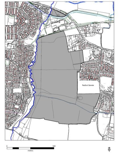
Background/Justification to Policy RS12
6.54 The Parish Plan (developed in 2014) stated that the village must retain its separate identity from neighbouring settlements or, it will cease to be a village. Future housing developments must exclude the possibility of the village being merged or contiguous with Leamington Spa, Sydenham and Whitnash.
6.55 The overall context for the Neighbourhood Plan is set by the Warwick District Local Plan which runs to 2029. It is therefore appropriate to have an area of separation which reflects the village envelope as determined for local planning purposes when the Local Plan was approved.
6.56 Feedback received from the community at all the consultations reinforces the importance of maintaining separation between Radford Semele and Leamington Spa, Sydenham and Whitnash. A very high percentage of attendees stated that maintaining the proposed area of separation was important otherwise the character and identity of the village would be lost. Erosion of this zone would effectively make Radford a suburb of Leamington Spa, Sydenham and Whitnash.
6.57 Coalescence can be defined as, "the process of coming or growing together to form one thing or system" (Cambridge English Dictionary). On this basis, the concept of coalescence is engaged not only when two settlements physically join, but also as they potentially come closer together. Therefore, in the context of the coalescence of settlements, a reduction in the gap between
settlements could also be described as part of the process of coalescence.
6.58 The Area of Separation identified in the RSNDP has been assessed as part of the work on the Warwick District Local Plan. Of particular relevance is the two studies, the Warwick "Green Belt and Green Field Review (2013)" and, the "Landscape Assessment Update (2014)."
6.59 The "Green Belt and Green Field Review (2013)" concluded that the area identified on the Policies Map 8 provided a "Strategically important Green Field parcel, that play[s] a role in maintaining the separation of Radford Semele from Sydenham [Royal Leamington Spa]". The conclusion in this study was that the overall value assessment of this area was "high".
6.60 The Landscape Assessment Update (2014) work concluded that the sensitivity of this area to new housing development was "high".
6.61 The importance of maintaining the openness of this area was also highlighted by the Inspector examining the Warwick District Local Plan:
"The submitted Local Plan already proposed substantial housing site allocations to the south of Leamington Spa, Warwick and Whitnash on land outside of the Green Belt. Planning permissions for significant additional amounts of housing were then granted through appeals concerning land at The Asps and Gallows Hill in January 2016.
The combined scale of housing growth committed and proposed in this area will result in the need for considerable infrastructure improvements, particularly in terms of the transport network. There are legitimate concerns, based on the Strategic Transport Assessments about significant further housing growth beyond this level in this area and the capacity to accommodate it. Whilst there is clearly strong demand from developers and the schemes under construction appear to be progressing well, any further significant increase in the concentration of housing in this relatively small geographical area would also raise concerns over deliverability, given potential competition between sites. There are also environmental constraints, not least the potential effect on the significance of heritage assets. In addition, there is a need to avoid coalescence with the village[s]…of … Radford Semele.[10]"
6.62 The area of separation has, where feasible, been drawn between the west of the Village boundary (as defined in the WDC Local Plan) and the Parish Boundary. This area of land represents open countryside which presently separates Radford Semele from its neighbouring towns of Leamington Spa and Whitnash. Maintaining this open space to avoid coalescence was a key request from the community. In 2014 a planning application for 65 houses at the end of Spring lane was submitted (ref: W/14/0433) which was refused by WDC. The application subsequently went to appeal but unfortunately was granted permission in 2015 under paragraph 14 of the NPPF. The erosion of this valuable space was a real blow to the community. This development is now under construction.
6.63 During the emerging Local Plan, a further site to the south (H52) was allocated for 60 houses. However, this allocation was removed following the granting of planning applications North of Southam Road (60), South of Offchurch Lane (150) and Opposite Radford Hall (25) and recommendations in The Report to Warwick District by the Planning Inspector (July 17).
"338 ……development would have a significant impact on the scale and form of the village and on the character and appearance of the area.
339. It is not necessary to allocate the site on land at Spring Lane (H52) in order to ensure sufficient housing growth in the village or to meet the overall housing requirements for the District. The adverse impacts of development would outweigh the benefits."
This area is now included within the Area of Separation.
6.64 Considering the sensitivity of this Area of Separation and its importance to maintain village separation it would be expected that any new proposed developments within the area would have to demonstrate that they have undertaken an assessment of all suitable alternative sites before submitting any applications.
OBJECTIVE 7: – To support and enhance the existing village economy.
(6) Policy RS13: - Local Economy
Development proposals which would support or enhance the village economy will be supported subject to conformity with other policies in the RSNDP and the development plan; in particular:
- small retail premises (Use Class A1);
- food and drink outlets (Use Classes A3 and A4);
- expansion of existing small businesses, and
- new small businesses.
Background/Justification to Policy RS13
6.65 The RSNDP area has a small number of local businesses. These provide valuable sources of local employment and help to provide a mix of uses that adds to the sustainability of the area. Local business and local employment offer people opportunities to live close to sources of employment and help minimise the need to travel.
6.66 Policy RS13 seeks to support local economic development related to existing small businesses and to also support suitable new development of small retail premises, food and drink outlets. In addition, support would be given for Doctor, Dentist and public health establishments as residents have to travel for these services. Such proposals must be in line with policy set out in the Local Plan, particularly that for town centre and retail development. The activities identified are in line with the feedback provided at previous RSNDP consultations.
6.67 As well as their main function our shops provide a meeting point and are an essential social community service, especially for those villagers with limited mobility.
6.68 The NPPF promotes the use of sustainable transport. The neighbourhood plan would support and encourage the development of sustainable businesses that would encourage environmentally friendly behaviours.
[7] Local Plan – Warwick District Council 2011 -2029
[8] Ofsted Report – Radford Semele CofE Primary School – June 2015
[9] NCA96: Dunsmore and Feldon – Natural England 2013
[10] para. 90, Report on the Examination of the Warwick District Local Plan, July 2017