Radford Semele Neighbourhood Plan - Regulation 16 Submission
(1) Appendix 2. Protected Small Open Spaces (Policy RS3)
This analysis has been undertaken to assess all other open spaces in the neighbourhood plan area and has been used to help determine which spaces are of greatest significance.
Extension, widening or provision of new cycle or footpaths, with the essential requirement that they will improve safe access and connectivity within the village should be allowed even if it encroaches on a small open space.
Although the fields that sweep up to the village give it a very rural feel, the main part of the village has become very much, a built environment. Every green space, however small, within the village is therefore very important in helping maintain its openness, of vital importance to the population. The gradual development of the village over time has not left much open space, so that which there is, is of special significance and should be retained. This applies to all the green verges and small green spaces such as the green in front of the village shop. There is little space for provision of extra open spaces, so any future development should seek to include spaces to enhance and extend those in the old part of the village.
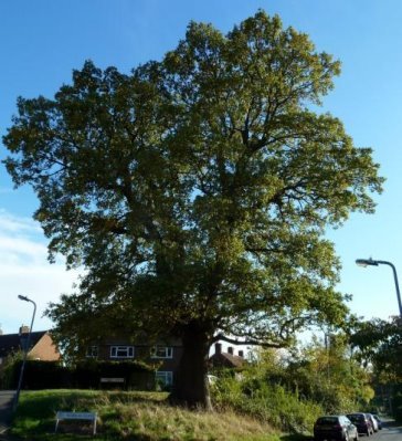
Figure 21- Magnificent Oak at the junction of St Nicholas Road and Lewis Road
|
Table A2 - |
Small open spaces (RS3) |
|
Policy Map 3 Ref |
Space and location |
Reason for inclusion |
Approximate size/distribution |
|
Value of area - Key: g = green 'lung' b = beauty v = view r = recreational t = trees w =wildlife h=historical |
|||
|
RS3/1 |
Green in front of village shops |
(g,r,t) A small green 'lung' with a tree, where people frequently use the bench and area for contemplation or conversation. The post-box and parish notice board are located here. |
0.02 hectares. |
|
RS3/2 |
Green verges and hedges at the end of Valley and Williams Roads |
(b,g,t,w) Special because it is along the village boundary where roads meet footpaths and greenway. Much used, visually pleasing and a calming area. Connects to The Greenway and thence to the paths leading to the Fosse. Used for local community parties. |
Made up of 3 semi-circular grassy verges totalling 0.16 hectares in area, with adjoining hedges, leading round to footpath at the rear of Williams Road |
|
RS3/3 |
Green spaces at the end of Valley, Lewis Roads and The Valley, where the track to Hillside Farm leads off the road, together with a triangular island on the junction. |
(g,b,w,t) These triangular green spaces, hedgerow and associated trees, ditch and verge form a very important wildlife corridor linking the Whitnash LWS with the Angly Hole LWS. Amphibians, notably Great Crested Newts and frogs and toads as well as Grass Snakes are found. Mammals (hedgehogs, foxes, badgers and bats) and many species of birds also use the habitat. In addition, of course, the well-grown hedgerow provides a visual treat. |
All relatively small (0.01 hectares), grassy areas |
|
RS3/4 |
The ditch, hedge and verge leading all the way along Valley Road and the Valley to the LWS 'Angley Hole' |
0.20 hectares. This 0.3km linear feature stretches along the 2 roads, except where the ditch is culverted under tracks or where the area narrows. At the most it is around 3-4m wide. |
|
|
RS3/5 |
The Greenway, South of Valley Road, a wide footpath, W120B connecting paths W120 and w119. |
(g,b,t,r,h) Many walkers use this path regularly; it is bordered on East side by a hedge with many mature trees with a meadow beyond. It also forms part of the network of green corridors so important in conserving wildlife. |
0.33 hectares. It ranges for 0.27km and its width varies from 12m to 26m wide. |
|
RS3/6 |
Area of sloping grass verge to the South of the junction of St Nicholas and Lewis Road. |
(t,g,b,w) Has a mature , magnificent oak tree pleasing to the eye, blending with the views beyond, down the hill and up the farm track. |
0.05 hectares. |
|
RS3/7 |
Hedgerow to the East of Lewis Road from St Nicholas Road to The Valley. |
(g,b,w) A broad hedgerow with a path from which some of St Nicholas Terrace properties are accessed. It provides a shady relief and is a pleasing region of green shrubs, trees and grass as well as being good for wildlife. |
190m long and 0.02 hectares in area |
|
RS3/8 |
Verge North of the junction of Godfrey Close with Lewis Road |
(g) A very small space that adds to the green space in a built-up area. |
0.01 hectares. |
|
RS3/9 |
Small roundabout at the end of Overtons Close |
(b,g,t,w) Provides a pleasant outlook for the houses in the Close, with shrubs and small trees. |
0.01 hectares. |
|
RS3/10 |
Verge North of the junction of Lythall Close with Lewis Road |
(g,b) Adds to the green space in a built-up area where paths are narrow, adds to the outlook of the adjacent green |
0.01 hectares. |
|
RS3/11 |
Verges North and South of the junction of Overtons Close with Lewis Road |
(g,b) Adds to the green space in a built-up area where paths are narrow, so contributing to the rural feel of the village |
0.01 hectares. |
|
RS3/12 |
The 2 wide verges either side of the junction of Hall Fields with Southam Road, extending up the side of St Andrews Hall Into Hall Fields. |
(g,b,t,r) These add a pleasant aspect to the A425 as it narrows. It is used by children's societies for environmental activities. |
Two spaces 0.06 hectares in area. |
|
RS3/13 |
The verge between the service road at the junction of Southam Road with Kingshurst |
(b,g) Buffers the adjacent houses from the A 425, making it safer for residents. |
A small finger of sloping land, 0.02 in hectares. |
|
RS3/14 |
The verge and hedge beside Leam View |
(b,g,t,w) A remnant of the natural hedge with well grown trees and shrubs. |
0.02 hectares. |
|
RS3/15 |
The area beside and in front of Ricardos, including lawn, trees and part of the old railway cutting, which is wooded. |
(b,g,t,w) A generously wide band of land, part lawn and cultivated trees, part with remaining natural trees, leading to the bank of the canal, where kingfishers are found. |
0.64 Hectares |
|
RS3/16 |
The wooded and scrub area of the old railway cutting on the side of Southam Road opposite Ricardos. |
(b,g,t,w) Adds to the rural feel as the village is entered. |
0.40 Hectares |
|
RS3/17 |
An area of boggy scrub and grassland North of the Southam Road at the end of the layby near the canal which is bordered by the Parish boundary Radford stream and River Leam. |
(b,g,t,w,v) This is very important as it forms a wildlife corridor linking Whitnash wildlife site, canal and river |
0.27 Hectares |
|
RS3/18 |
The hedges and verges either side of the Southam Road from the Parish boundary to the Canal on the South side and the old railway cutting on the North side. |
(b,t,w) Again, these add to the rural feel of the area and support wildlife. |
186m (north) and 194m (South) in length, area 0.16 hectares. |
|
RS3/19 |
The lawn verges outside Radford Hall. |
(b,g,v,h) Lawn which sets off the historical wall and view of Radford Hall. |
0.03 hectares. |
|
RS3/20 |
Verge to the N of Southam Road from Radford Hall to the junction with Offchurch Lane. |
(b,v,t,w,h) A wide verge with cultivated trees, allows unimpeded views of the historic church to passing traffic and pedestrians. |
0.38km in length, 0.17 hectares. |
|
RS3/21 |
Verge and hedge from opposite Hall Fields, past the bus stop to the junction with the road to Semele Park |
(b,g,w,t) A narrow verge with trees and shrubs, many overhanging from adjacent gardens. Adds to the rural feel of the village. |
A narrow verge. 0.16 hectares in area. |
|
RS3/22 |
Verge along NW of Offchurch Land, by footpath |
(g,b,t,v) Generous grassy verges, with some trees which add to the rural aspect of the village. |
400m by 6m, 0.20 hectares in area. |
|
RS3/23 |
Steep verges on both sides of Offchurch Lane beyond the footpath leading from the village. |
(t,b,w,h) These wooded areas have ancient woodland plants rare in the Parish and offer a shady 'tunnel' of trees. There are remnants of the dismantled railway and the road is sunken. |
Narrow areas alongside road, 0.01 hectares in area. |