Radford Semele Neighbourhood Plan - Regulation 16 Submission
(2) Appendix 1: Local Green Spaces (Policy RS2)
|
A1 |
Local green space is a very strong planning policy designation set out in the National Planning Policy Framework (NPPF). |
|
|
A2 |
Policy for the designation of Local Green Spaces is set out in paragraphs 99 to 101 of the NPPF:
|
|
|
A3 |
All green spaces in the Neighbourhood Area have been assessed for their potential designation as Local Green Spaces (Table A1a). Those meeting the designation criteria are shown on the Policies Map. Local wildlife sites are privately owned and managed; this designation does not imply any right of access. |
Table A1a. Protected Local Green Spaces
|
Green or Open Space |
Is the site in close proximity to the local community it serves? |
Demonstrably special to a local community |
Local in character and not an extensive tract of land? |
|
RS2/1 - Church Fields (East & West) |
400m north west of the Village centre. |
A unique open green space seen by visitors when entering and leaving village along the A425. The views into these fields are of special importance to the community, giving Radford Semele its village identity. The space provides beautiful views of the iconic St Nicholas Church, key heritage assets and the surrounding countryside typical of the Dunsmore and Feldon NCA. The area provides a quiet agricultural setting for listed buildings/monuments (Parish Church of St Nicholas, Churchyard Boundary Wall and Lychgate to South of Church, The White Lion Public House, The Glebe House, 64 and 66 Southam Rd and The Manor Cottage). The much-loved view has remained largely unchanged since medieval times. At night the area to the east is dark and tranquil because there is little in the way of artificial lighting, giving a rare aspect of the setting when approaching the church along Church Lane. Previous excavations on the east field have identified a possible 'shrunken' settlement, previously part of the medieval settlement of Radford Semele. At the entrance into Church Lane is the site of the ancient village stocks. WDC have included this area within the Conservation Area for the canal corridor. This area provides a valuable open space for Flood Risk management. |
The site is 8.59 hectares and is best described as two agricultural fields with defined boundaries. The field to the east of Church Lane is actively farmed and used to grow a variety of crops. The field to the West of Church Lane is mainly grassland and is sometimes occupied by horses and sheep. Both fields have no public access which is important to retain the quiet tranquil setting presently enjoyed by St Nicholas Church and the other Grade II listed buildings. The field to the west of Church Lane has high landscape value and the field to the east has high to medium landscape value. |
|
RS2/2 – Leigh Foss |
South eastern edge of the village 300m from village centre. |
Used by the community for dog walking and by ramblers to connect with the countryside through a permissive footpath, this beautiful grassy space provides a circular walkway. Outline planning applications (W/16/1489 & W/17/0514) have identified that this area contains protected species, having a population of Great Crested Newts located in the pond in the NW corner and Grass Snakes in the main field. Bats also forage in and around the area. It has mature hedges and trees add to the beauty of the area and the view. It has been allowed to develop into ruderal grassland, of which there is a scarcity in Warwickshire, so is of importance ecologically. The pond together with the open space provides drainage and is important in flood management within The Valley area which has flooded on two separate occasions since 2000. Being a small field, it evokes the feel of pastures from years gone by with the changing seasons being reflected in the wildflowers which appear along with the changes in the hedgerows. It is a peaceful area. |
Covers an area of 1.70 hectares, bordered on 2 sides by housing and open countryside on other two sides. Through the site is a much-used permissive footpath fenced off from the main field which connects the countryside with The Valley. There is an application to have this footpath made a public footpath as this path has been in use for many years. The field and pond are fenced off so are protected from public access. This is important to maintain the balance of protected species habitat. On 3 sides it has thick hedges with mature trees, with ruderal grassland in the main area of the field. It is linked to Angley Hole and wood by hedges and ditches so providing a wildlife corridor from east to west of the village leading to Whitnash Local Nature Reserve. |
|
RS2/3 – Angley Hole and Woods |
South eastern corner of the village at the end of The Valley 400m from village centre. |
This special space is close to the village and is regularly and frequently used by residents as a tranquil walk that can be incorporated into a circular route around the edge of the village, adding to the well-being of those who use it. Horse riders pass through on the bridleway. Demonstrably special this largely unimproved rough pasture had been designated a Local Wildlife Site and is one of the few areas of pasture that is accessible to villagers via a public footpath. It supports a diverse wildlife population, including Great Crested Newts. The privately owned area has been planted and managed by a local farmer to provide a protective habit for much wildlife and a tranquil space as is Turkey Pool on the Southern border of the LNR. This area provides a valuable open space for Flood Risk management |
The field is small in area (3.89 hectares) compared with the modern, larger fields which dominate the parish. It incorporates an old sunken track, hedgerows and many mature trees and is typical of the Feldon landscape. Through the centre is a main public right of way (a bridleway) which links with some of Radford Semele's key footpaths and links eventually to the Fosse Way. This field and pathway are extensively used by walkers and for dog walking. The woods are enjoyed by the community for walking and to link with other footpaths which circumnavigate the village. |
|
RS2/4 – North Offchurch Lane/South Canal |
The area is approximately 900m from the village centre and is next to the new phase II Semele Park development. The area is very close to houses on Offchurch Lane. |
The area has a permissive path which is highly valued by villagers as a tranquil space for walking and reflection and provides a short walk beneficial for health and well-being. It hugs the canal corridor providing beautiful views of the countryside. Warwick District Council are considering designating it a Conservation Area. |
The site is approximately 5.8 hectares. This is a new woodland carefully planted with a number of native tree species and with wide grass pathways. It also encompasses part of the now defunct [Rugby to Leamington Spa] railway line and a World War 2 pillbox |
Table A1b – Open Green Spaces Considered But Not Designated as a Local Green Space in RS2
|
Open Green Space |
Proximity to the local community it serves? |
Special to a local community |
Local in character and not an extensive tract of land? |
|
GS4 – North Offchurch Lane/South Canal |
The area is approximately 900m from the village centre and is next to the new phase II Semele Park development. The area is very close to houses on Offchurch Lane. |
The area has a permissive path which is highly valued by villagers as a tranquil space for walking and reflection and provides a short walk beneficial for health and well-being. It hugs the canal corridor providing beautiful views of the countryside. Warwick District Council are considering designating it a Conservation Area. |
The site is approximately 5.8 hectares. This is a new woodland carefully planted with a number of native tree species and with wide grass pathways. It also encompasses part of the now defunct [Rugby to Leamington Spa] railway line and a World War 2 pillbox |
|
GS5 – Area to South of Spring Lane Development |
West of and adjacent to main village recreation field, connected by short path. |
Provides beautiful views to the SW when walking along footpath between Spring Lane and Valley Road. The old spinney on the west side of the field is an interesting site for wildlife, including foxes, buzzards and many other varieties of birds. The field does not have public access but has footpaths to the east and west and is regularly used by dog walkers and ramblers If this area was developed it would have a significant impact on the scale and form of the village and adversely affect the character and appearance of the area. |
Location: 2.3 Hectares. Bounded to the west and south by hedges and open countryside and to the north and east by existing housing. To the north there will be a new development of 65 houses (construction due to commence in 2018). The field links the central village with open countryside and key wildlife areas. The Warwick District Local Plan planning inspector considered 'that development of this site would result in a further clear and substantial extension of the built-up area into open countryside. |
Additional Criteria Used to assess the significance of the green spaces:
|
Criteria |
Description |
|
Landscape Beauty, Character & Setting
|
Landscape value, Valued setting of a designated building and land value |
|
Historic Features Significance |
Of Historical value, Contains historic buildings or, churches or a historic landscape |
|
Recreational & Community Value |
Used by the community for walking, recreation or sporting activities |
|
Openness & Tranquillity
|
Quality of the open space. Its tranquillity or valued tranquillity as a setting. Value as an open space for its views etc. |
|
Richness of Wildlife
|
Wildlife habitats, known protected species and value on the natural wildlife. |
|
Natural Environment |
Geology, Landform, Vegetation, Trees and hedges |
|
Degree to accommodate change without adverse impact on character. Sensitivity to developments. |
|
|
Demonstrably special to Village |
Valued highly by residents based on comments received during drop in events & consultations. |
|
Designation/Status/Owners objection |
Any existing designations or known objections by landowners. |
|
Close to village Community
|
Accessibility by public from the village centre (i.e. stores/post office). |
Assessment
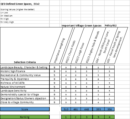 Table A1c - Scoring
The overall scoring was weighted on the bases of its importance to the village community and the requirements of the NPPF for Green Spaces. All of these areas were put forward based on community feedback gained at drop-in sessions, consultations and general comments.
Based on the output of Table A1c it was decided to only put forward RS2/1-RS2/3 as protected Local Green Spaces. These open green spaces stood out in our assessment (over 400 and significantly higher than the next open space). In particular, RS2/1-RS2/3 had high scores in the areas of "Demonstrably Special to the community", "landscape sensitivity", "Tranquillity and openness", "Richness of wildlife" and rated high in the other areas defined. Additionally, these valued open Green Spaces had the unique attributes which address the requirements for open Green Spaces as defined in the NPPF.