Land East of Kenilworth Development Brief
In this section Development Principles are identified which can assist in the delivery of the Land East of Kenilworth objectives set out in chapter 6.
The principles, where applicable, have been produced taking into consideration the strategic, settlement and neighbourhood level analysis in chapter 4 and the site level analysis examining constraints and opportunities in chapter 5. Development principals have also been informed by discussions with infrastructure providers and internal and external consultees and by specialist external consultant advice with regards to highways/transportation and design matters.
The Development Principles, along with guidance contained elsewhere within this Development Brief , shall be taken into account in the preparation of planning applications and their subsequent determination.
(8) 1. Delivery[AC2] of a mix of housing to create a sustainable community
Objective 1: To deliver approximately 1,400 new dwellings including a mix of dwelling types, sizes and tenures, including affordable housing, to meet a broad range of needs and deliver a mixed and sustainable community Relevant WDC Local Plan Policies: DS2 'Providing the Homes the District Needs'; DS11 'Allocated Housing Sites'; H0 'Housing'; H2 'Affordable Housing'; H4 'Securing a Mix of Housing'; H5 'Specialist Housing for Older People'; H15 'Custom and Self-build Housing Provision'; SPD Affordable Housing (2008); Provision of a Mix of Housing (2018).
Policy DS11 allocates land for an estimated 1,400 dwellings across the two strategic housing sites that this Development Brief covers. The capacity of the sites will depend on a range of factors and therefore may ultimately differ from this number. Any significant increase or decrease in dwelling numbers from the Local Plan numbers will require robust justification to demonstrate why such a deviation should be considered acceptable.
The site provides an opportunity to deliver a range of housing that meets the housing needs of Warwick District, neighbouring Coventry and the Town.
Market Housing
It is anticipated that a majority of housing will be the provision of open market dwellings. A mix of dwelling types in accordance with Policy H4 of the Local Plan will be required to provide choice and meet the housing needs of the District.
Affordable Housing
Affordable housing contributes to the creation of sustainable mixed communities. Housing development on strategic allocations H06 and H40 will be subject to Policy H2 of the Local Plan which requires 40% of the total (gross) number of dwellings provided on the site to be affordable. The policy also highlights that the sizes, types and tenures of homes provided will be determined on the basis of local need and sets out other requirements that developers will need to follow with regards to the affordable housing. The affordable housing shall be 'tenure blind' and well- integrated into the overall development with market housing with consistent qualities of materials, design and open spaces and where achievable it shall be pepper-potted around the development.
Proposals for the development of greater levels of affordable housing than the policy requirement of 40% will be supported subject to compliance with other Local Plan policy and other material considerations and the requirement for an overall mix of housing types across the entire Development Brief site.
At outline stage developers are expected to set out their approach to meeting the District's affordable housing policies and full details of the affordable housing to be delivered will be required at reserved matters stage.
Housing Mix
As per Local Plan Policy H4 sites will need to provide a mix of market housing that contributes towards a balance of house types and sizes, including the housing needs of different age groups. Warwick District Council's note 'Provision of a mix of housing' (June 2018) provides further detail on providing a mix of housing.
Unless further local information is provided that justifies a diversion away from the housing mix identified in the 2013 Coventry and Warwickshire Joint Strategic Housing Market Assessment (JSHMA) housing developments will be expected to meet the housing mix as set out in the JSHMA and in Table 1.
Table 1: Housing Mix Table
| |
One bed |
two bed |
three bed |
four bed |
|
Market mix |
5 – 10% |
25 – 30% |
40 – 45% |
20 – 25% |
|
Affordable mix |
30 – 35% |
25 – 30% |
30 – 35% |
5 – 10% |
Specialist Housing for Older People
Specialist housing for older people will be supported within the site subject to conformity with Local Plan Policy H5. In particular, the housing shall be suitably located to allow for easy access to public transport and local shops and amenities. As no primary care facilities are likely to be delivered on the site, public transport will be required to link the development to existing local primary care facilities.
Specialist housing shall include on-site private amenity areas whilst also being closely connected to greenspaces and paths within the development.
Purpose Built Student Accommodation
Some purpose built student accommodation may be acceptable in the area subject to it being located close to public transport routes serving either Warwick or Coventry University and the new local convenience retailing facilities. Within or adjacent to the Local Centre is likely to be the most appropriate location for such uses.
Development Principle 1A: A mix of homes to meet existing and future needs
- A mix of market and affordable housing shall be provided and be informed by up-to-date evidence of the District's housing needs. It shall include a mix of dwelling sizes and accommodate suitable housing for older people;
- Affordable housing shall be provided in accordance with Policy H2 of the Local Plan and the Council's adopted Affordable Housing Supplementary Planning Document. The affordable housing shall be pepper-potted around development sites and shall be indistinguishable from market housing.
Self-Build and Custom-Build Housing
Warwick District Council supports self-build housing to help promote greater diversity in the local housing stock, and encourage the use of innovative design and the provision of more affordable and sustainable development.
A local register identifies demand for self-build and custom-build plots within the District and also specifically in Kenilworth. The register identifies particular demand for larger detached self-build homes. As of 30th May 2018, the register includes 34 expressions of interest in Kenilworth, which equates to approximately 10% of the total entries on the register. Furthermore, 15 on the register are interested more generally in sites across Warwick District (including Kenilworth), 30 across Warwickshire County and 41 not specified. Given these statistics, in order to meet the demands within the District as indicated by the register, it is essential that there is delivery of self-build and custom-build plots on strategic housing sites such as at Land East of Kenilworth.
Local Plan Policy H15 encourages custom and self-build housing and identifies major strategic housing sites as being suitable and sustainable locations for their delivery subject to all other relevant policy requirements. It highlights that the Council will produce an SPD to assist in the delivery of custom and self-build dwellings and a draft version will be consulted upon in late 2018/ early 2019. Should there be a conflict between this guidance and the proposed Custom and Self- Build SPD once adopted, developers are advised to follow the requirements of the Custom and Self- Build SPD.
Policy KP4 of the Kenilworth Neighbourhood Plan includes a requirement for a proportion of the total number of the open market homes to be provided within the site to be as serviced plots for self-build and custom-build, commensurate with demand evidenced on the local authority self-build register of interest. Should there be a conflict between this guidance and the proposed Custom and Self-build SPD once adopted, developers are advised to follow the requirements of the Custom and Self-build SPD.
In harmony with the Local Plan policy and Neighbourhood Plan this SPD sets out a requirement that all major housing sites within the overall site shall provide 5% of the total number of open market homes as serviced plots for custom and self-build or a lower percentage should evidence at the time of submission demonstrate that a lower percentage will meet demand. This provision shall be provided on each site unless a more preferable whole site wide strategy can be agreed between landowners and the Local Planning Authority.
In order to ensure the delivery of housing and avoid large areas of land being undeveloped this guidance supports a cascade mechanism relating to the custom and self-build plots if demand does not materialise in a timely fashion.
Further requirements are laid out in order to ensure that the individual street scene is not broken up with discordant custom or self-build properties; to ensure the plots meet housing needs; to ensure plots are available and viable; and to ensure marketing reaches those who have already expressed an interest in custom and self-build.
Development Principle 1B: Custom and self-build housing
Custom and self-build housing plots shall be provided within the development in accordance with the following:
- All major housing sites within the overall site shall provide a proportion of open market homes as serviced plots for self-build and custom build, commensurate with demand evidenced on the self-build register of interest, not exceeding 5% of the total number of dwellings;
-
 Custom
and self-build plots shall accord with the following
principles:
Custom
and self-build plots shall accord with the following
principles: - Custom and self-build plots shall be grouped in clusters rather than individual plots dispersed throughout the site;
- The mix of plot typology offered should respond to the most recent Strategic Housing Market Assessment (SHMA) or subsequent documents;
- Plot size should conform to the average size of plot typology provided on the remainder of the site;
- A plot shall have the following infrastructure in place and to edge of the plot prior to marketing: legal access to a public highway, electricity, gas, water, foul drainage, broadband conduits;
- The Local Planning Authority must be contacted prior to the commencement of marketing of available plots. The Authority may then take the opportunity to contact those on the Custom and Self-build Register and/or use their website to promote the opportunity;
- Plots which have been made available and marketed appropriately for at least 12 months from the start of development, and have not sold, may either remain on the open market as self-build or custom-build or be offered to the Council or a Registered Provider, at market value, before being built out by the developer conforming to the appropriate market housing mix. Evidence of marketing must be provided to the Local Planning Authority.
(6) 2. Delivery of high quality employment land and employment opportunities
Objective 2: To deliver a high quality employment park on 8 hectares of land to the southern end of the site and promote opportunities for local employment during construction and post-occupation of development Relevant WDC policies: DS8 'Employment Land'; DS9 'Employment Sites to be Allocated'
8 hectares of land is allocated to the southern end of the site for employment purposes. Policy DS9 of the Local Plan specifically allocates site E1 (Land at Thickthorn, Kenilworth) for uses in category B1 (Business) and B2 (General Industrial) of the Town and Country Planning (Use Classes) Order 1987, as amended. The explanatory text to the policy highlights that the supply of good quality employment land in Kenilworth is limited and this site will provide the opportunities for a mixed employment development able to meet local and wider needs of the District. The size of the site was considered appropriate by the Local Plan Inspector in order to meet a variety of demands.
Use Class B1 includes offices, research and development of products and processes and light industry appropriate in a residential area. B2 includes uses for industrial processes other than those falling within Class B1. Any development proposals that seek to include B8 uses, retailing, quasi-retail or sui generis uses within the site will not be supported.
The shape of the employment site shall be as set out in the Local Plan policy map for Kenilworth and offers the potential to provide a buffer to screen new residential from noise and air quality issues associated with the A46 to the east of the site. However, minor deviations to the shape of the site may be considered acceptable if this would help with the overall delivery of employment and housing to the southern area of the site and if the overall area for employment land and housing within the southern section of site H06 remains unchanged.
The employment site shall be designed to ensure the development is compatible with neighbouring residential uses so that uses located near to existing and proposed residential properties are limited to suitable B1 uses. This will help minimise the potential for noise and other disturbance to residential properties. The scale and design of buildings shall relate well to neighbouring residential areas and the design of buildings shall have due regard for the nearby listed buildings of Thickthorn Manor and Thickthorn Stables as well as the setting of the Grade II* listed Registered Parks & Gardens of Stoneleigh Abbey.
Furthermore, buildings of high quality design offering visual interest will be required in the more visually prominent areas of the site, including those at the corner of Leamington Road and the Thickthorn roundabout and any other site entrances. Whilst there is an expectation that mature trees in this area are retained where possible and thus will provide screening, this is a gateway into both the site and Kenilworth and development will be expected to be of a high standard and emphasise a sense of arrival. To further separate the employment land with neighbouring residential, a landscape buffer of a suitable width to allow for mature, dense tree/vegetation screening and act as a potential wildlife corridor.
Whilst there should be no through route for vehicles between the employment land and residential areas to separate traffic and avoid rat running, an emergency access shall be provided along with good pedestrian and cycle connectivity between the uses to encourage sustainable travel. The employment land shall also be well-connected to the Local Centre and public open space, providing leisure and convenience shopping opportunities for workers.
The employment land is highly accessible given its location immediately off the A46, which in turn is well-connected to other major roads in the strategic highway network. The site is also located close to major employers including Warwick University, Coventry University and Jaguar Land Rover
and therefore has the potential to provide opportunities associated with research and development for those growing organisations.
WDC are supportive of a mix of employment within the site including a range of different sized units available for a variety of different businesses. Within that mix, in particular the District will be supportive of and encourage start-up business space, business grow-on space and flexible office space.
A planning condition is likely to be placed upon any consent relating to the site requiring local employment and training opportunities during the construction of the development and post-completion.
Development Principle 2: Employment Land
In developing the employment land the applicant is expected to accord with the following guidance:
- The employment land shall be laid out in an efficient manner to maximise the use of the land for employment purposes;
- Uses within the employment land shall include only B1 and B2 uses and not B8 or non-employment uses;
- More compatible employment uses shall be located closer to adjoining residential properties to minimise the potential for noise disturbance;
- The scale and design of buildings shall respect neighbouring residential areas and have due regard to nearby heritage assets;
- A landscape buffer of a suitable width shall be provided to allow for dense mature planting to screen the site from neighbouring residential areas.
- Buildings shall be of high quality design and in more prominent areas and gateways to the site buildings and landscaping will be expected to emphasise a sense of arrival;
- The site shall be well connected by footpaths and cycleways to neighbouring residential areas, the development spine road, the Local Centre and public open space;
- A Local Employment and Training Plan will be required to provide construction and
(49) Objective 3: To deliver an effective and efficient transport system allowing the safe movement of traffic, appropriately designed and located walking and cycling routes and public transport connectivity
Relevant WDC Policies: Local Plan Policies: TR1 ‘Access and Choice’; TR2 ‘Traffic Generation’; TR3 ‘Parking’; HS1 ‘Healthy, Safe and Inclusive Communities’;
It is vital that good connectivity is provided from the site to key destinations including Kenilworth Town Centre, Kenilworth Railway Station, local centres, schools, employment sites, leisure facilities, open spaces, the strategic highway network and wider cycle network to ensure that the development provides residents with a choice of sustainable travel options, in accordance with the NPPF Chapter 9 'Promoting sustainable transport'.
New development on Land East of Kenilworth will generate additional travel demands and it is important to ensure that any significant impacts of additional vehicular traffic are mitigated.
Off-site highways improvements, carefully considered access arrangements and routes through the site will seek to minimise these impacts. The provision of facilities for public transport and measures to improve connectivity between the site and the Railway Station will assist. Furthermore, the creation of a pedestrian and cycle friendly development which provides for routes within the site, connects to existing routes and also contributes towards the funding of off-site improvements whilst also reducing the reliance upon the private car will also lessen these impacts.
This section identifies existing capacity constraints on the local highway network that are relevant to the development and makes recommendations about how these may be mitigated as well as identifying other key highway infrastructure required.
All developments will be expected to provide for an appropriate package of sustainable travel measures including:
- Provide sustainable mix of uses on site, arranged in such a way to reduce the need to travel;
- Arrange streets and spaces to encourage a safe and legible walkable neighbourhood where key community infrastructure facilities are connected;
- Provide legible, safe and direct formal cycle routes and where feasible 'leisure' cycle routes; and
- Provide infrastructure and funding to support public transport services linking the site with neighbouring settlements, the Town Centre and Railway Station.
(2) Walking and Cycling
The development should prioritise wherever practicable continuity, accessibility and permeability by active travel modes (pedestrian and cycle movements) to ensure that this is more convenient and attractive than using a car. Kenilworth has a higher level of car ownership than both the national and district level average and the scale of this development presents an opportunity to provide a shift in travel behaviours.
Walking and cycling assist with health objectives by promoting healthy and active lifestyles and also environmental objectives including improving air quality. They also offer a cheaper alternative to the use of the private car.
Provision for cycling within the site, the connections to the existing road network and other cycle routes will need to be designed to a high standard and should adhere to the core quality principles as identified in the Department for Transport's Local Transport Note (LTN) 2/08 'Cycle Infrastructure Design' and LTN 1/12 'Shared use routes for pedestrians and cyclists'. These are:
- coherence;
- directness;
- safety;
- comfort; and
- attractiveness.
In accordance with Manual for Streets, the internal network of roads and streets should be designed such that cyclists can be accommodated safely within the road network. Where traffic levels and speeds are higher, such as on spine roads, dedicated provision for cycling is required.
Short, direct links for pedestrians and cyclists will be required to create a permeable network of high quality links, connecting streets and different areas and uses of the development. Links can be identified as a shared path facility and the minimum usable width for links is 3m and will need to take note of building lines, fences and boundary walls.
Filtered permeability should be included within the layout to ensure that direct routes for pedestrians and cyclists are retained, and short trips are visibly more convenient by active travel modes than by car.
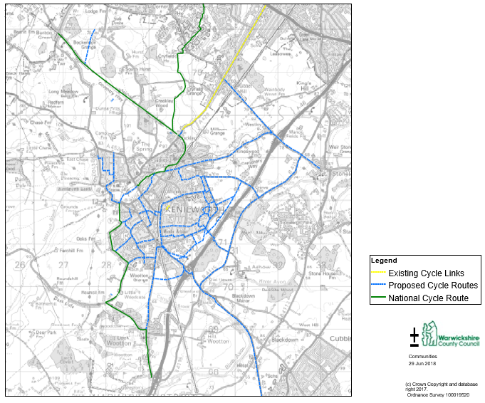
To promote sustainable travel, a comprehensive cycle network will be required to serve the new development, connecting the site to key destinations within Kenilworth and neighbouring settlements. The Kenilworth Cycle Network Plan (Figure 24) has been developed to provide a comprehensive plan for cycle connectivity within Kenilworth setting out a number of indicative routes with the aim of providing convenient and attractive links to key destinations including the town centre, railway station, schools, employment sites, leisure facilities and the wider cycle network.
Retro-fitting dedicated cycling infrastructure onto the existing road network is often difficult due to constraints on available highway width and road layouts. Many residential roads in the eastern part of Kenilworth have relatively low traffic flows and speeds, and are therefore suitable for on-carriageway cycling for most types of cyclists. However, the layout of the existing residential area and the barriers created by the A452 and the railway line means that there are a relatively limited number of potential through routes connecting to the town centre.
The links shown on the plan include a mixture of the following infrastructure improvements to the existing highway network:
- New off-carriageway shared use footways / cycleways adjacent to busier roads
- On-carriageway cycle links on quieter residential streets (where only signing, lining and / or minor infrastructure improvements may be required)
- Upgraded traffic-free links that provide short-cuts for cyclists, avoid busy roads or connect up residential streets
- Enhancements to the crossing points over the railway line, which currently creates a barrier to east-west cycling movements
- Informal crossing points, zebra crossings and signalised crossings where required to overcome barriers to active travel created by busy roads.
S106 contributions should be sought towards the development of the necessary pedestrian and cycling infrastructure to serve the site and ensure strong connectivity and access to Kenilworth Town Centre, Railway Station and neighbouring settlements.
Figure 24: Kenilworth Cycle Network Plan
Developments are expected to conform with the following detailed guidance relating to cycling and walking infrastructure:
Cycling provision on spine roads serving the residential and employmentsites
Dedicated cycling infrastructure is required on the main spine road as it will have higher traffic flows and speeds than the other residential roads within the site. It shall also be provided along the spine road of the employment site to encourage sustainable travel to work.
The preferred provision for cyclists on the spine road within the development site is a cycle track on both sides of the carriageway which is segregated from the footway, with a verge separating the cycle track from the carriageway.
A surfaced width of a minimum of 4 metres would enable provision of a footway and cycleway with some form of separation. However, discussions should take place between developers and Warwickshire County Council (WCC) concerning the specific requirements for cycling provision on each section of the spine road.
Consideration should be given to minimising the need for cyclists to frequently stop and start, which impacts on the convenience and attractiveness of cycle routes. Where the spine road crosses minor side roads, giving priority to the cycling and pedestrian facilities should be considered if vehicle flows on the side road will be less than 2000 per day. This may require raised table crossing points which are set back from the junction to enable a waiting space for turning vehicles. On very quiet roads, in line crossing points may be preferred. Further discussion with WCC will be required at the design stage regarding the above options.
Junctions should be designed to promote low vehicle speeds, for example by using raised tables and tight junction radii, as set out in Manual for Streets.
There should be suitable provision for people to cross the spine road at regular intervals and to cater for all journeys within and through the development.
As the spine road will not run through the central part of the site owing to the ecological and heritage constraints around Glasshouse Spinney and will instead adjoin Glasshouse Lane, there should be a direct cycle/pedestrian link which connects the northern and southern sections of the spine road to create a direct and continuous cycle and pedestrian route. This route shall also connect with the two public footpaths traversing the site.
Crossings
To encourage cycle usage, interruptions to routes requiring cyclists to stop/start should be minimised and cycle tracks should be given priority at minor side roads and private accesses, where vehicle flows are low.
Informal refuge crossings will need to be designed to accommodate a non-standard cycle and family group. Traffic lane widths between 3.10m-3.90m at refuges should be avoided as they can create pinch-points for cyclists using the carriageway where drivers may try to overtake when there is insufficient room.
Signalised or zebra crossings should be provided as appropriate. The use of parallel pedestrian and zebra crossings should be included where it enables continuity of route for both pedestrians and cyclists.
Shared paths through green corridors
To complement the on-highway provision, a network of high quality shared use paths through open spaces should be provided where they enable greater permeability for pedestrians and cyclists
for north-south and east-west movements. These routes should have a minimum usable width of 3 metres, be hard surfaced, have an open aspect, be appropriately lit and be overlooked.
A secondary network may be included where usable path widths can be reduced to 2.0m and may be softer surfaced i.e. limestone. These routes are to be designed to create walking loops, linking with residential streets, the main spine and key north-south and east-west bicycle corridors.
Connections to the wider network
In order to promote greater active travel and encourage shifts in transport modes, it is essential that more high quality access points are provided for pedestrians and cyclists than vehicles. New residents to the development should be able to conveniently reach local destinations by cycle or on foot and not have to make long detours.
Access controls
The pedestrian and cycle routes within the development should remain free of barriers, bollards and obstruction. The design of the road layout on the approach to crossing points should ensure that the motorised traffic slows or stops, however path geometry should also be designed such that a cycle or pedestrian cannot shoot straight across a road.
Connecting links beyond the site boundary should remain free from obstruction where practicable to do so (link to existing off road facilities). Where there is a requirement for slowing cyclists, this should be undertaken through geometric alignment and the use of strategically located bollards. All access control should remain permeable for pedestrians and cyclists, including the use of non-standard or adapted bicycle designs.
Wayfinding / signing
Signing of pedestrian and cycle networks within the development site should ensure that key locations within the site are easily accessible. Signing should also highlight key destinations beyond the site boundary, such as the town centre, schools, railway station and leisure facilities. This signing should include direction, destination and distance information as appropriate to raise awareness of the pedestrian and cycle links from the site. Clear, consistent and comprehensive route signage will also be required along each of the identified pedestrian and cycle links serving the site.
S106 contributions will be required towards the delivery of the necessary signage, as part of the development of external cycle routes linking the sites with nearby destination.
Development Principle 3A: Cycling and Walking
Developments within the site shall promote and encourage cycling and walking as attractive modes of travel and shall accord with the following principles:
- The West Midlands Cycling Design Guidance (WMCDG) (2017) sets out the underlying design principles that will give cyclists sufficient safety and priority to encourage this mode and provides details of the preferred type of infrastructure in difference situations. Provision for cycling within the development site, the connections to the existing road network and other cycle routes shall be designed to a high standard and adhere to the core quality principles as identified in Local Transport Note (LTN) 2/08 'Cycle Infrastructure Design'. All applications for major development relating to the site shall demonstrate that the development is in accordance with the WMCDG and that the LTN principles are being addressed.
- All major applications shall prioritise wherever practicable continuity, accessibility and permeability by active travel modes (pedestrians and cycle movements) to ensure that this is more convenient and attractive that using a car. In conformity with Manual for Streets, the internal network of roads and streets shall be designed such that cyclists can be accommodated safely within the road network. Where traffic levels and speeds are higher, such as on spine roads, dedicated provision for cycling is required.
- Short, direct links for pedestrians and cyclists will be required to create a permeable network of high quality links, connecting streets and different areas of the development. Links can be identified as a shared path facility. The minimum usable width for links is 3.0m and will need to take note of building lines, fences and boundary walls.
- Dedicated cycling infrastructure shall be provided on the main spine road as it will have higher traffic flows and speeds than other residential roads within the site. It will also be a key road in north-south movement across the site and the connectivity of the site with other destinations.
- Developments shall contribute towards the provision of necessary off-site pedestrian and cycling infrastructure to serve the site and ensure strong connectivity and access to Kenilworth Town Centre, Railway Station and neighbouring settlements.
- A scheme for the signing of pedestrian and cycle networks within the development site shall be submitted to and approved by the Local Planning Authority as part of any detailed application (full or reserved matters application). The signposting will improve wayfinding and ensure that key locations within the site are easily accessible and shall also highlight key destinations beyond the site boundary such as the town centre, schools, railway station and leisure facilities. The signing shall include direction, destination and distance information as appropriate to raise awareness of the pedestrian and cycle links from the site. Clear, consistent and comprehensive route signage will also be required along all identified pedestrian and cycle links serving the site. S106 contributions will be required from each development towards the delivery of the necessary signs, as part of the development of external links from the site.
- Secure and conveniently located cycle parking shall be
provided throughout the development, as set out in Warwick
District Council's Parking Standards Supplementary Planning
Document (2018), to accommodate short and longer stay
visitor use and regular long stay use by residents.
(12) On and Off Site Highway Infrastructure
It is of critical importance to the success of the development that appropriate on and off-site highways infrastructure is provided to serve and meet the demands of the new development and ensure there is no significant adverse impact upon the safe and free flow of traffic in the town.
A highways study ('Kenilworth Transport Study') has been commissioned and undertaken to inform this Development Brief and this identifies a number of highway infrastructure requirements and makes a number of recommendations. The Kenilworth Transport Study has therefore informed this section of the Development Brief.
Existing Access
There are currently a number of minor accesses serving existing on site uses (see figure 22). These accesses relate to farms, dwellings and sports clubs. There are no public roads that run through the site. Existing accesses are taken from Crewe Lane (Crewe Garden Farm; and a separate dwelling), Glasshouse Lane (Southcrest Farm; Kenilworth Wardens; Kenilworth Rugby Club (two sites) and a dwelling) and Leamington Road (a farm/dwelling).
Public Rights of Way
There are two recorded Public Rights of Way that travel through the site or immediately adjoin the site
– W202 (Glasshouse Wood path) and W212 (Rocky Lane). Both footpaths run east-west across the site and are located along the northern and southern boundaries of the existing sports club sites respectively.
The indicative masterplan in this Development Brief shows the two rights of way being retained without any significant penetration through. This preserves the existing Ancient Woodland, an existing Local Wildlife Site and the biodiversity value and ecological corridors it provides whilst also enabling the established footpaths to be retained without diversion.
Both Public Rights of Way offer existing and future residents of Kenilworth good access to surrounding countryside whilst also providing attractive woodland routes.
Development Principle 3B: Public Rights of Way
In considering existing public rights of way developments are expected to:
- retain the existing public rights of way, W202 (Glasshouse Wood) and W212 (Rocky Lane) through the site along their existing alignment;
- where possible accommodate the public rights of way within a landscaped corridor or open space away from vehicular traffic;
- provide improvements to the surface and lighting of the public rights of way to encourage their use.
Traffic Speed
In the interests of highway safety and to promote walking and cycling within the development, traffic speeds throughout the development shall be 20mph except on the Spine Road which shall be 30 mph. Where the Spine Road travels through adjacent, the Local Centre speeds shall be reduced to 20mph.
The section of Glasshouse Lane abutting the western edge the Education allocation (ED2) shall be reduced to 20mph in the interests of safety.
Development Principle 3C: Traffic Speeds
Maximum traffic speeds within the development shall accord with the following:
- Maximum traffic speeds throughout the development, within residential and employment areas shall not exceed 20mph, except for the spine road;
- The spine road shall have a maximum speed limit of 30mph but this should be reduced where the road travels through a Local Centre;
- The section of Glasshouse Lane to the west of the education allocation shall have a maximum speed of 20 mph.
Proposed Access
In order to minimise conflict between employment and residential uses it is considered preferable for separate accesses to be provided from the south of the site into the housing and employment allocations.
Employment site access
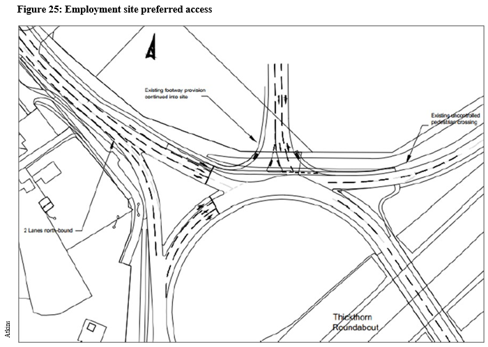
The Kenilworth Transport Study considers access to the proposed employment allocation, E1. In examining the feasibility of access for the site geometric constraints, junction operation and design standards have been considered to identify a preferred site access.
Various options were considered as set out in the report with the preferred option being direct access and egress from the A46/A452 circulatory which will mean that HGVs can avoid the A452 Leamington Road (Figure 25). The A46/A452 roundabout is proposed to be signalised regardless of this development and the preferred option would add a signalised fifth arm on the roundabout. The proposed arm would be located between the A452 (N) Leamington Road and the A46 northbound on-slip, consisting of one entry land and two exit lanes onto the circulatory. A potential alternative to this approach could be to combine the employment site and residential site access via a junction on Leamington Road, with access into the employment site being provided towards the southern end of the spine road.
It is considered that this option will provide direct access and egress between site E1 and the A46/A452 grade separated signalised roundabout, whilst resulting in minimal impact upon the geometry of the existing roundabout and other arms. It would also have minimal impact to the A452 (N) Leamington Road as it limits the need for additional access points. Further detailed assessment will be required on the impact of the capacity of the roundabout and whilst subject to detailed design, the feasibility and Kenilworth Transport Study found that the access can
be provided to relevant highway standards based on information available at this stage.
Developers of the employment site/southern part of HO6 are strongly recommended to liaise with Warwickshire County Council and Highways England with regards to this access.
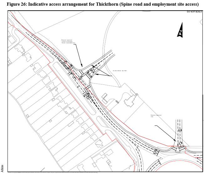
Access from A452 Leamington Road
Figure 26 highlights how access to the spine road from Leamington Road can be achieved in the context of the preferred option for access to the employment site. A signalised controlled T-Junction is preferred with a left and right lane heading out of the site onto Leamington Road and a single lane into the site. Heading southbound on Leamington Road one left turn lane and one lane to travel straight on could be accommodated. Two lanes are proposed on the A452 Leamington Road Atkins northbound from the A46 roundabout also accommodating storage for right turn movements onto the spine road and minimising potential for queuing back to the A46 roundabout.
It is important that pedestrian and cycle crossing facilities are provided at the junction. Figure 26 demonstrates that it should be possible to provide Toucan crossings at the junction linking the shared footways/cycleways on the spine road with the proposed shared footway/cycleway on the south of Leamington Road as identified on the Kenilworth Cycle Network Plan.
Development Principle 3D: Thickthorn Access (employment and housing allocations)
Access to the southern end of the site shall accord with the following:
- Separate accesses shall be provided to the employment land (allocation E1) and the housing allocation (H06) to minimise conflict between employment and residential uses unless it is demonstrated that this is not feasible, unviable or undesirable in terms of safety;
- Primary access to the employment site shall be via a direct access/egress off the A46/A452 circulatory unless it is demonstrated that this is not feasible, unviable or undesirable in terms of safety. The access or any alternatives must operate well with the new spine road access;
- The spine road access from Leamington Road shall provide for appropriate pedestrian and cycle crossing facilities both across Leamington Road and across the spine road itself and these shall connect with existing footway/cycleways in the immediate vicinity as well as provision on the new spine road; and
- Pedestrian and cycle access shall be provided into the employment site in suitable locations to encourage travel to the site by alternatives to the private car. This shall include connection(s) between the employment site and the spine road.
Crewe Lane/Spine Road access and altering the function of CreweLane
Crewe Lane, running east-west to the north of allocation H40 provides an opportunity to provide an access into the north of the site and connect to the spine road.
The road is currently a two-way single carriageway providing access to Crewe Farm, a residential dwellinghouse and Kenilworth Golf Course. The road has no footway provision, centreline or road markings and vehicles often travel at speed along the road.
The proposed development is likely to increase the use of Crewe Lane. The junction of Crewe Lane and Glasshouse Lane has restricted visibility and therefore it is recommended that access at this junction is restricted to in only. This would act as a one-way system on the western section of Crewe Lane, although access to the Golf course and residential properties would be maintained from the eastern side of Crewe Lane and the spine road.
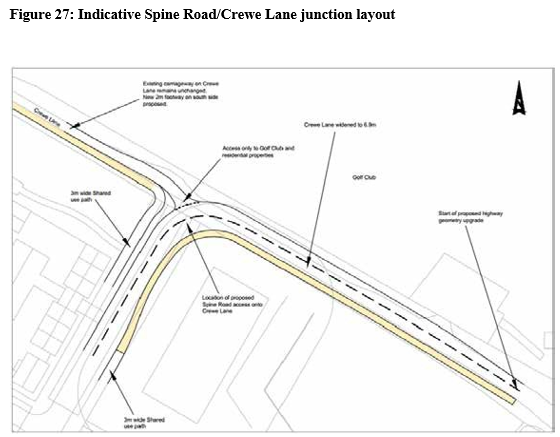
It is recommended that the section of Crewe Lane between the northern end of the spine road and the Golf Course access is retained as an informal access road, without a centreline, to encourage vehicle use of the spine road. The addition of a footway to the south side of the carriageway is however recommended.
The spine road/Crewe Lane junction should be designed as a priority junction, with the north west section of Crewe Lane forming the minor arm (see Figure 27 below). The spine road/Crewe Lane (east) would provide the mainline and encourage traffic to use the spine road to access Leamington Road and the A46 Stoneleigh junction. The eastern section of Crewe Lane is proposed to be upgraded to a formalised two-way carriageway, although the feasibility of this beyond the A46 bridge is limited.
The west section of Crewe Lane would provide a pedestrian and cycle link to Glasshouse Lane and would also connect with the spine road footways/cycleway(s).
Crewe Lane/Glasshouse Lane/Hidcote Road Junction
The current Crewe Lane/Hidcote Road/Knowle Hill staggered junction is located just outside the north eastern boundary of the site. It is located at the crest of a hill and an existing hedgerow limits visibility on Crewe Lane when approaching Glasshouse Lane. The proposed development, including the new secondary school, is likely to increase traffic flows passing through the junction and therefore the feasibility of different junction improvements has been considered in the Kenilworth Transport Study.
Various options to ensure a safe and effective arrangement were considered with the preferred option, shown in Figure 28 including a combination of measures that were considered. This includes restricting access from Crewe Lane as well as traffic calming measures at the junction. This would improve junction visibility, simplify movements at the junction, calm traffic approaching the development site and improve pedestrian and cycle provision.
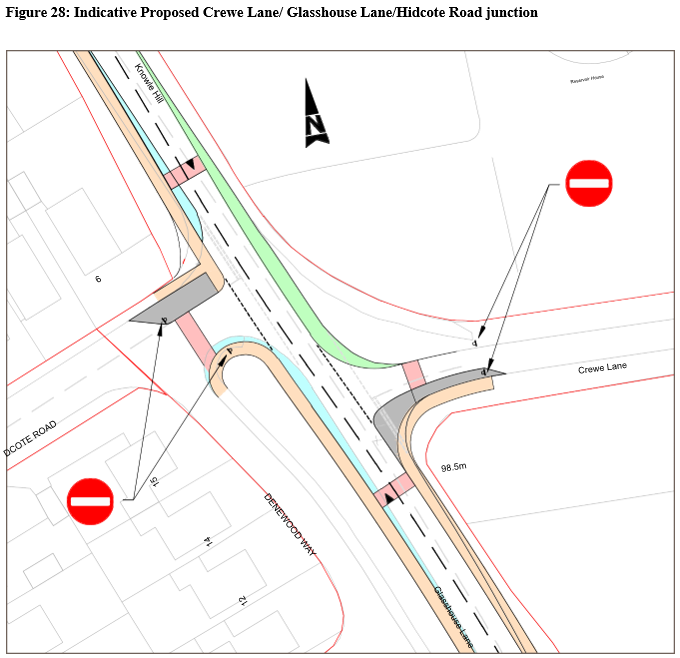
Development Principle 3E: Crewe Lane
- The spine road/Crewe Lane junction should be designed as a priority junction, with the north-west section of Crewe Lane forming the minor arm. The spine road/Crewe Lane (east) should provide the mainline and encourage traffic to use the spine road to access Leamington Road and the A46 Stoneleigh Junction. An indicative layout is shown in Figure 28.
- The western section of Crewe Lane shall become an in-only junction with no access onto Glasshouse Lane from Crewe Lane, acting as a one-way system on the west section of Crewe Lane. Access to the Golf Course and residential properties on Crewe Lane shall be maintained form the east side of Crewe Lane/Spine Road junction. A footway shall be introduced along the southern side of Crewe Lane between Glasshouse Lane and the Crewe Lane/Spine Road junction.
- Junction improvements shall be undertaken to the Crewe Lane/Glasshouse Lane/Hidcote Road junction to restrict access from Crewe Lane and introduce traffic calming measures at the junction and provide a safer junction for pedestrians and cyclists to negotiate. The preferred approach is shown in Figure 28.
- The spine road junction shall be delivered by developers of the northern parcel of land on H40 early within the development of that parcel of land. The alterations to Crewe Lane shall also be delivered early to encourage modol shift.
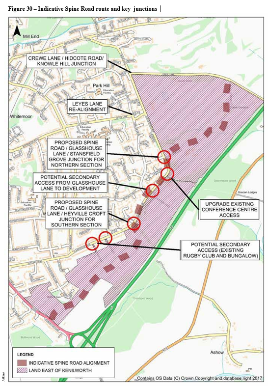
Spine Road
Perhaps the most significant new on-site highway infrastructure is the need for a spine road to run north-south through the site connecting the entire site.
The spine road will be the main distributor road running through the proposed development linking Leamington Road in the south and Crewe Lane in the north. The spine road will be used by bus services and will be the main road through the development for north-south movements and will travel through/adjacent the Local Centre.
In order to minimise the impact of development upon a local wildlife site and Ancient Woodland
at Glasshouse Spinney and two existing public rights of way (Glasshouse Wood Path and Rocky Lane) and owing to the retention of Woodside Hotel within the site, the route of the spine road shall start from Crewe Lane in the north and Leamington Road in the south with these sections of the spine road both joining Glasshouse Lane thus providing the central section of the spine road along Glasshouse Lane.
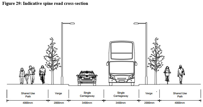
Spine road specification:
- The spine road shall run through the northern and southern sections of the site, but run along Glasshouse Lane in the middle section of the development site;
- The southern section of the spine road shall run from A452 Leamington Road to the south to a junction with Glasshouse Lane in the vicinity of Heyville Croft;
- Glasshouse Lane where it becomes the central part of the spine road will require upgrading to the same specification as the northern and southern sections of the spine road, but would only require footway provision on the east side of the carriageway;
- The northern section of the spine road will connect with Glasshouse Lane, north of the retained Woodside Conference Centre and Hotel and in the vicinity of Stansfield Grove, to Crewe Lane to the north of the site;
- The carriageway shall be no less than 6.8m in width;
- It will have a 30mph speed limit, with 20mph when passing zones through/adjacent the Local Centre. Where achievable, it shall be designed to have bends in the road to assist in speed reduction;
- Off-street parking will be designed for residential properties but some ad-hoc on-street parking is assumed and can be accommodated;
- Limited vehicular accesses to residential properties will be supported;
- 2m wide grass verges incorporating street trees of suitable species given the width and proximity to the road and footway/cycleway will be provided on both sides of the carriageway; and
- Footway/cycleway provision shall be provided. Ideally, 3-4m wide shared footway/cycleways shall be provided on both sides of the carriageway. As an absolute minimum a 4m shared provision should be provided on one side and a 2m footway on the other side. Figure 29 shows an indicative cross-section of the preferred spine road design.
Figure 30 opposite shows the indicative alignment of the spine road and the key junctions.
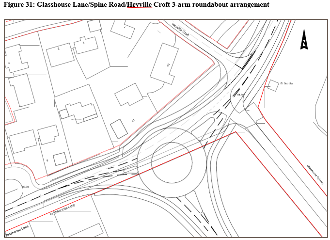
Spine Road/Glasshouse Lane/Heyville Croft Junction
In order to avoid Rocky Lane the spine road will need to connect with Glasshouse Lane which will form the central part of the spine road. A junction will therefore be required to the northern end of the
Jersey Farm land in the vicinity of Heyville Croft where there is a gap between existing dwellings on the southern/eastern side of the road and the protected Rocky Lane.
Glasshouse Lane/Heyville Croft is a priority junction with Glasshouse Lane acting as the major arm and runs north to south, and Heyville Croft, acting as the minor arm and serving a residential cul-de-sac to the northwest.
A roundabout is considered the most appropriate junction arrangement and the feasibility of different junctions was considered in the Kenilworth Transport Study. The Study concludes that a 3-arm roundabout arrangement can be accommodated connecting the Spine Road with Glasshouse Lane as indicated in Figure 31. Junction capacity modelling undertaken through the study also highlights that the proposed junction operates well within capacity on all arms during both peaks.
The roundabout would connect the southern and central sections of the Spine Road (the central being an upgraded Glasshouse Lane) and also provide access to the southern part of Glasshouse Lane which runs into Birches Lane. This option also provides a separate priority junction for Heyville Croft and maintains pedestrian and cycle access to Rocky Lane. As part of the upgraded Glasshouse Lane forming the central Spine Road, pedestrian and cycle access will be able to continue along the road with suitable crossing facilities at key junctions.
Glasshouse Lane/Spine Road Northern Section/Stansfield Grove junction and upgraded Woodside Hotel Access
Given the retention of Woodside Lodge and Woodside Hotel, albeit the latter with reduced sized grounds, and the requirement to retain Victoria Spinney, there are limited potential access points for the northern spine road to meet Glasshouse Lane. The preferred option is in the vicinity with
Stansfield Grove. Glasshouse Lane/Stansfield Grove is a priority junction with Glasshouse Lane acting as the major arm and running north to south and Stansfield Grove, a short residential cul-de-sac, acting as the minor arm to the west. A secondary access to Woodside Hotel is located opposite to Stansfield Grove.
The Kenilworth Transport Study recommends a 4-arm roundabout junction connecting Glasshouse Lane, the northern section of the Spine Road and Stansfield Grove, as indicated in Figure 32. The junction has been modelled and the junction capacity results highlight that the junction operates well within capacity on all arms during both peaks.
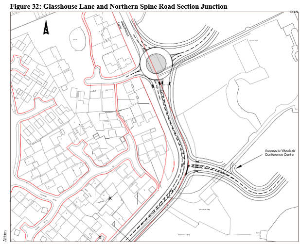
>Access into Woodside Hotel and Conference Centre is currently precarious owing to the speed of traffic, the bend in Glasshouse Lane and the sharp turn into the site. The Kenilworth Transport Study has considered an alternative access arrangement to address this concern, which would see the Woodside Hotel access being relocated approximately 25m north to achieve improved visibility splays and provide a right turn lane (see Figure 32). This would also have the potential to form a secondary access to the residential development with a priority junction providing access to the hotel.
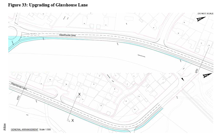
Glasshouse Lane between Heyville Croft and Stansfield Grove is constructed to a good standard. However, for the road to serve as an effective Spine Road additional highways land is required to alter the geometry of the road and enable pedestrian and cycle provision on the eastern side of the road. Figure 34 below indicates where additional highways land will be required.
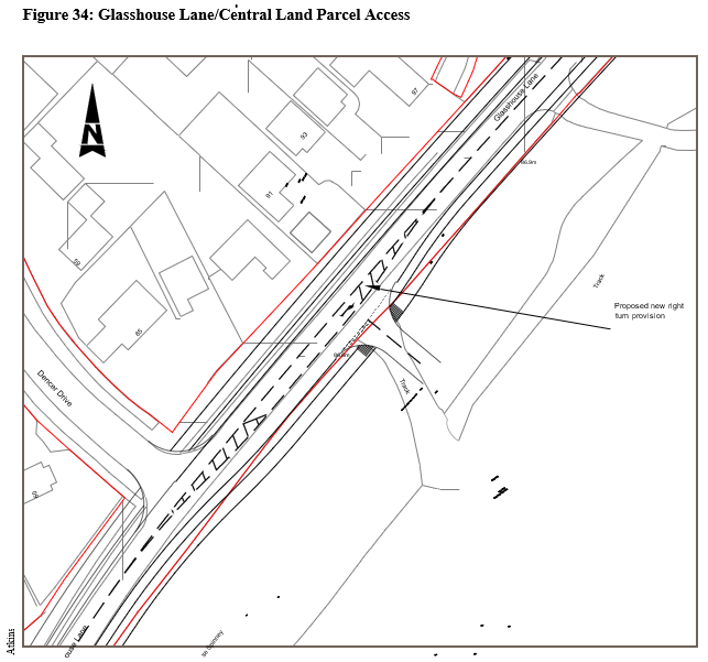
Glasshouse Lane/Central Land Parcel (Sports club sites) Access Junction
With the route of the Spine Road avoiding Glasshouse Spinney, appropriate access must be provided into the central parcel of land which will provide a mix of uses as identified in the Indicative Masterplan within this Development Brief . The Kenilworth Transport Study has identified a suitable location for an access as being to the north of Dencer Drive in the vicinity of the existing Rugby
Club access as shown in Figure 34. An access in this arrangement will have the least impact upon Glasshouse Spinney as there is already an access track serving the sports club.
A junction capacity analysis has been undertaken which demonstrates that this arrangement would work well within acceptable thresholds of capacity on all arms across both peaks.
Development Principle 3F: Spine Road
A spine road shall be provided in a north/south direction within the site. The spine road shall accord with the following:
- The specification of the spine road shall adhere to the 'Spine road specification' set out in this development brief;
- The southern spine road access shall be taken from Leamington Road and it is recommended that a junction is provided in a similar location and of a similar design to that identified in Figure 26 'Indicative access arrangement for Thickthorn';
- The northern spine road access shall be taken from Crewe Lane and it is recommended that a junction is provided in a similar location and of a similar design to that in identified in Figure 27 'Indicative Spine Road/Crewe Lane junction layout';
- The part of Glasshouse Lane forming the central section of Spine Road shall be upgraded and widened to enable pedestrian and cycle provision to the eastern side of the road;
- A new access shall be provided into the central parcel of the site preferably broadly in the location of the existing Rugby Club site access;
- Developers of land within H40 shall provide the spine road accesses and junctions relating to the northern Spine Road section, developers of land within the southern part of H06 (south of Rocky Lane) shall provide the Spine Road accesses and junctions relating to the southern Spine Road section and developers of the central parcel of land between Rocky Lane/ Glasshouse Wood Path shall provide for the central Spine Road widening improvements.
Other Accesses
Should a part of the education allocation, ED2, be developed for housing, any access into the site should have an appropriate relationship with and pay due consideration to the identified Crewe Lane/ Glasshouse Lane and the new Secondary School access. A residential access onto Glasshouse Lane within the vicinity of Crewe Lane is unlikely to be considered acceptable unless and until the Crewe Lane/Glasshouse Lane junction improvements have been completed.
It is anticipated and recommended that Kenilworth School will be accessed from Glasshouse Lane. Appropriate pedestrian and cycle facilities shall be provided to enable safe access to the school and also a crossing facility over Glasshouse Lane to ensure that the school is suitably connected to the existing town. An off-highway drop-off area should be provided to minimise the impact upon the safe flow of traffic on Glasshouse Lane. Should some housing within the site be constructed prior to the opening of Kenilworth School, developers of that housing shall provide for a crossing facility to provide safe crossing facilities to enable pupils to safely reach the existing Kenilworth School.
Further potential accesses may include:
- Access off Glasshouse Lane into Jersey Farm land (currently providing access to a bungalow)
- Access off Glasshouse Lane into Kenilworth Rugby Club (freehold site)
- Accesses off Thickthorn Close (west and east)
These potential accesses will be unlikely to be considered appropriate as main access points into the wider site and any development off these accesses would need to demonstrate its connectivity with the remainder of the site. It is likely that the number of dwellings accessed off Thickthorn Close will be limited and through routes to the Spine Road are unlikely to be supported for vehicles (but will be required for walking and cycling).
Impact upon residential amenity will be a consideration when assessing the suitability of these four access points. While not proposed for vehicular access, the accesses do offer good potential for use as emergency access points and enable opportunities for good connectivity to the existing town for walking and cycling.
Development Principle 3G: Other Accesses
The development shall accord with the following guidance:
- Appropriate access shall be provided to serve the new Kenilworth School. This shall be off Glasshouse Lane and the school shall provide an off-highway drop-off area. Suitable pedestrian crossing facilities shall be provided across Glasshouse Lane and pedestrian and cycle infrastructure shall encourage pupils to uses sustainable travel from all residential areas within the Land East of Kenilworth site.
- Should any part of ED2 be developed for residential purposes, a suitably designed access into the site shall be provided. The access shall not be utilised to serve any residential development unless and until Crewe Lane/Glasshouse Lane junction improvements have been completed to the satisfaction of the Local Highways Authority. Access to the site must also be located and designed giving due regard to the proposed Secondary School site access;
- Further secondary accesses into the site may be supported to serve a small number of dwellings; act as emergency accesses; and/or provide sustainable travel links to existing residential areas.
Off-site Highway Improvements
St John's Gyratory
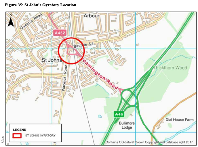
Junction capacity results have shown the Warwick Road arm of the junction to be over capacity in both peaks when modelled with the 2029 Local Plan Model and therefore junction improvements are required to be delivered to ensure the successful operating of this key junction linking the town centre with Thickthorn roundabout, Leek Wootton and Birches Lane.
The Kenilworth Transport Study has considered the feasibility of junction improvements to the St. John's Gyratory including changing the priority of the junction so that the gyratory gives way to the approach arms, full signalisation, roundabouts on the main approach arm junctions and localised improvements on the Warwick Road approach.
Having undertaken the analysis the preferred option is the full signalisation of the gyratory at the Warwick Road and Leamington Road junctions, with Birches Lane remaining un-signalled. The preferred option is shown in Figure 36. This option could be accommodated within the existing layout with only minor geometrical alterations to kerbs and lining. The footway adjacent to the petrol station on Warwick Road would however be lost and the impact of this on visibility requirements for vehicles exiting the petrol station will need to be considered further by applicants. Access to the existing petrol station from Warwick Road could be retained and this solution would allow for increased opportunities to provide controlled pedestrian and cycle crossing points.
The alterations are likely to provide minor improvements to traffic flows during peak times and would provide increased control to manage queuing and delay. Integration with proposed signalised junctions further south on Leamington Road and at the A46/A452 junction could improve vehicle flow during peak times.
Development Principle 3H: St.John's Gyratory Improvements
Given existing capacity constraints, at a very early stage in the development of the site, full signalisation of the St.John's Gyratory shall have been delivered in accordance with a scheme agreed by the Local Highways Authority. All residential developments within the site shall contribute towards these improvements through s106 contributions.
Dalehouse Lane
Figure 37: Dalehouse Lane/Knowle Hill location
The Dalehouse Lane/Knowle Hill priority junction is located to the north-west of the site, with Knowle Hill adjoining Glasshouse Lane near to the site. The approach arm from Knowle Hill is split by an island for left and right turners respectively. Given the relationship of this junction to the site the junction has been analysed to consider the impact of development upon its operation.
The analysis, considering 2029 Local Plan flows, highlights right turn movements from Knowle Hill are not operating within capacity during the AM Peak. It is recommended that a signalised junction arrangement is implemented to accommodate the proposed development flows. Figure 38 shows an indicative signalised arrangement at the junction which would both improve performance of the junction and present an opportunity to incorporate the existing pedestrian crossing on Dalehouse Lane to improve pedestrian and cycle connectivity and minimise delay for motorists.
Development Principle 3I: Dalehouse Lane/Knowle Hill Junction Improvements
At an early stage in the development of the site, junction improvements to improve the capacity and performance of the Dalehouse Lane/Knowle Hill Junction shall be undertaken in accordance with a scheme agreed by the Local Highways Authority. All residential developments within the site shall contribute towards these improvements through s106 contributions.
Leyes Lane Realignment
The eastern end of Leyes Lane involves a staggered crossroads arrangement that requires a right turn onto Dencer Drive for approximately 25m before continuing onto Leyes Lane where the road then meets Glasshouse Lane.
In order to improve legibility, highway safety and minimise journey times to the new school and generally to Land East of Kenilworth from much of the existing town the feasibility of options to improve the highway alignment for anticipated increases in flows from the development and the relocated school has been undertaken as part of the Kenilworth Transport Study. This included a signalised crossroads arrangement and a compact roundabout arrangement.
The Study concluded that a signalised crossroads arrangement would be preferable, as this would provide more continuity between junctions and improved pedestrian and cycle crossing facilities (see Figure 39).
Figure 39: Indicative Leyes Lane/Dencer Drive Signalised Junction
Development Principle 3J: Realignment of Leyes Lane
Contributions will be sought from residential developments for the new school towards a scheme for the realignment of Leyes Lane to be agreed by the Local Highways Authority. The realignment of Leyes Lane shall be completed prior to the use of the new Secondary School.
Other Off-Site Highway Works – It is possible that there will be further off-site highway works required and that development on the site may be required to contribute towards those works. Detailed Transport Assessments prepared to support and inform planning applications will identify the details of any further off-site schemes that may be necessary. Depending upon the final access arrangements into the southern end of the site and Highways England's plans for signalisation of the Thickthorn Junction, contributions may be sought from developments with regards to this signalisation.
Public Transport
After 53 years without a railway station within the town, a re-built Kenilworth Railway Station opened on 30th April 2018 and provides a stop on an hourly service between Coventry and Royal Leamington Spa. The station offers significant travel opportunities for residents and businesses of the town in terms of accessibility to both employment and leisure opportunities and provides an alternative to the use
of the private car. For train travel to be used as a means of travel between the new development sites and neighbouring settlements for these purposes it is essential that there is good connectivity between the site and railway station.
In order to ensure a range of travel options are available to residents of the new housing and to provide access to the employment allocation, education facilities, the Local Centre and community facilities, a public transport system serving these areas and linking them with the town centre and railway station is essential and further links to neighbouring Coventry and towns within the District are also desirable.
Given its location to the edge of town, without careful consideration the new development has the potential to be isolated. However, access to public transport services together with measures to encourage walking and cycling between the new development and these destinations will ensure that a well-connected and sustainable development is delivered.
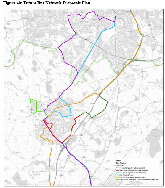
The main bus service currently serving the town is the Stagecoach X17 service, which operates every 15 minutes from the town to both Coventry and Royal Leamington Spa. Constraints including the urban topology and existing pattern of highways makes it practically impossible to service the site with a simple diversion of current services, without effectively abandoning the vast majority of existing neighbourhoods in Kenilworth served by the routes concerned.
Working with Warwickshire County Council's Public Transport team and Stagecoach (the main bus operator in the area) consideration has been given to how best meet the public transport needs of the development site. The spine road as set out in chapter 7 has the opportunity to act as an
alternative corridor for the express bus service X18 between Evesham-Stratford-Warwick-Leamington and Coventry with a 6.7km diversion between the Stoneleigh and Thickthorn A46 junctions.
The area on completion will benefit from four main points of potential access by bus:
- The New junction off A452 Leamington Road at the southern end of the site
- The Dencer Drive/Glasshouse Lane junction
- The Glasshouse Lane/Leyes Lane or Hidcote Road junctions
- The New Crewe Lane junction at the northern end of the site
In order for the spine road to be an effective route for buses the carriageway must be no less than 6.2m in width (and widened where necessary on bends) and entirely clear of parked cars. The spine road will need to have priority between Leamington Road and the B4115 Crewe Lane junction (as far as it is possible) to be both economically viable and ensure that the existing nature and function of the X18 service is not unduly compromised. Stagecoach have indicated that it is essential, under all likely conditions, that the bus can make a single trip between the Thickthorn and Stoneleigh Interchanges, including stops to pick up and set down, in no more than 15 minutes each way.
It may also be necessary for a southbound bus priority lane to be added to Crewe Lane to the B4115 Warwick Road junction and bus priority will need to be included in proposals for access into the site from Leamington Road. Alterations to the Thickthorn and Stoneleigh junctions of the A46 are subject to capacity improvement proposals and it is recommended that bus priority is included in design proposals for these areas.
The diversion of the inter-urban Stagecoach service X18 through the development as a whole could be achieved with a single additional bus in the X18 cycle to provide a service every 30 minutes in both directions.
A second half hourly local 'town service' between the development site and Kenilworth Railway Station and Town Centre has also been identified as being necessary and this could operate with a single bus. This would link the new residential, employment land, local centre and community facilities with Kenilworth Railway Station, Kenilworth Town Centre retailing and other businesses and existing medical centres.
S106 contributions will be sought from developers for the purpose of covering the costs of the re- directed X18 service and the bus subsidy cost of operating the town service. The X18 diversion could be achieved through the developer and Stagecoach Midlands both entering into a legal agreement or through pooled contributions payable to the Local Planning Authority or Warwickshire County Council as the Local Highway Authority. For the town service, as each new major development is applied for, the respective developer will be asked to make a contribution towards funding the extension and frequency enhancement of the town based service over a period of time necessary to appropriately serve occupiers of the new development. Indicative costs at the time of writing suggest a total cost of providing the local half hourly town service as being in the region of £490,000 over 6 years and the diverted X18 service £450,000 over the same period.
Whilst not a requirement, given the air quality benefits of electric buses, developments will be looked upon favourably which seek to incorporate opportunities for the provision of electric buses and electric bus infrastructure.
Figure 40 indicates the routes of the new and diverted services that are recommended to be provided to support the travel needs of the new community.
Development Principle 3K: Public Transport Services
To promote sustainable travel and alternatives to the private car and ensure that the development is well-connected to the existing town and neighbouring settlements development shall accord with the following principles, where applicable:
- Developments shall contribute towards the provision of new public transport routes providing access to/from:
- Neighbouring settlements including Coventry, Royal Leamington Spa and Warwick; and
- Kenilworth Town Centre retailing and medical centres, Kenilworth Railway Station, the new residential, employment land, local centre and community centre within this site;
- The spine road and associated junctions shall be designed to accommodate bus movements;
- A bus turning facility and lay-by area shall be provided close to the northern end of the spine road near to Crewe Lane;
- On-street bus stop infrastructure shall be provided within 400m of every new dwelling unless in exceptional circumstances.
Summary of highway infrastructure requirements to deliver an effective and efficient transport system
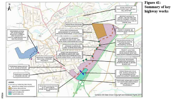
This section has been informed by the Kenilworth Transport Study and input from the Local Highways Authority. Where recommendations are made these are based on information available at the time of writing and as schemes are developed, further detailed design, junction capacity assessments and Road Safety Audits will be required. A summary of the key recommendations in the Kenilworth Transport Study is shown in Figure 41 (note the references to Castle Farm are not relevant to this Development Brief).
A summary of the key transport schemes to be delivered to ensure that the development has an acceptable impact upon the local highway network is set out in Figure 42 with Table 2 providing the associated key. The table identifies where developers will be expected to contribute towards the funding of highways and transport infrastructure.
Figure 42: Kenilworth Transport Development Plan
Table 2: Kenilworth Transport Development Plan Key
|
Map Ref |
Scheme |
Scheme Description |
Est. Delivery Date |
Estimated Cost |
Funding Sources |
|
1 |
Thickthorn Junction Improvements |
Provision of a signalised roundabout with widening of approaches to 3 lanes and potential for roundabout arm to access employment site |
2023 |
£17m to include dualling to Bericote and improvement to Bericote rounding (2018 prices) |
Potential MRN Funding/ Growth Deal/s106 Agreement/HE RIS Proportionate developer contribution to be determined |
|
2 |
# A46 Link Road Ph.1; Stoneleigh Junction Improvements |
Major upgrade to junction of A46 with C32 Stoneleigh Road & Dalehouse Lane will enable future delivery of A46 Link Road Phase 2 and 3. Junction improvement involves reconfiguration of slips, construction of new bridge and formation of a gyratory layout to junction |
2021 |
£36m (2018 prices) |
County Infrastructure Fund/DfT Major Scheme Funding. WMCA Devolution Deal Contributions from east Kenilworth sites not required |
|
3 |
Thickthorn Development Site Access |
Options being considered for the access to the Thickthorn development involving either access from the Thickthorn roundabout and/or an additional signalised junction on the A452 west of Thickthorn. Direct access/egress onto the Thickthorn circulatory is the preferred option for the employment site |
2021 |
Developer-led scheme |
s278 To be delivered entirely by the developer for the southern parcel of land |
|
4 |
Crewe Lane Development Site Access |
Priority junction between Crewe Lane and development spine road with the western section of Crewe Lane becoming the minor arm |
2020 |
Developer-led scheme |
s278 To be delivered entirely by the Catersby development |
|
5 |
Glasshouse Lane Development Site Access South |
Potential for 3 or 4-arm roundabout serving Glasshouse Lane, Thickthorn development spine road and Heyville Croft |
2023 |
Developer-led scheme |
s278 To be delivered entirely by the developer for the southern parcel of land |
#Schemes unlikely to require contributions or delivery by East of Kenilworth sites
|
6 |
Glasshouse Lane Development Access North |
Proposed 4-arm roundabout serving Glasshouse Lane, Crewe Farm, development spine road and Stansfield Grove. Relocation of Woodside Conference Centre to provide improved visibility |
2020 |
Developer-led scheme |
s278 To be delivered entirely by the Catesby development |
|
7 |
Crewe Lane Restricted Vehicle Movement |
Options being explored for realignment of junction, installation of traffic calming measures and restricted vehicle movements |
2023 |
Developer-led scheme |
s106 |
|
8 |
Knowle Hill/ Dalehouse Lane Junction Improvement |
Signalisation of junction incorporating the existing pedestrian crossing to improve connectivity for pedestrians and cyclists |
2023 |
£300,000 |
s106 or CIL |
|
9 |
A452 St John's Gyratory Improvement |
Signalisation of the four entry arms onto the junction |
2021 |
£1,000,000 |
s106 or CIL |
|
10 |
# Fishponds Road/ Castle Farm Junction Improvement |
Existing unction to provide access to Castle Farm Recreation Development |
|
Developer-led scheme |
s278 To be delivered entirely by Kenilworth wardens/ WDC developers(s) |
|
11 |
Leyes Lane Access to School Site |
Signalisation of realigned Leyes Lane junction and provision of pedestrian and cycle facilities to improve access to proposed school site |
2021 |
£500,000 |
s278 To be delivered entirely by the Kenilworth School development |
|
12 |
# Dalehouse Lane Junction Improvement |
Realignment and expansion of Dalehouse Lane/Stoneleigh Road junction as part of A46 Link Road Phase 1 |
2023 |
Included with scheme/cost |
County Infrastructure Fund/DfT Major Scheme Funding. WMCA Devolution Deal |
|
13 |
# B4115 Stoneleigh Junction Improvement |
Signalisation of junction of B4115 and Birmingham Road, Stoneleigh to facilitate link between A452 Leamington Road at Thickthorn and A46 Stoneleigh junction |
2021 |
Developer-led scheme |
s106 To be delivered by Stoneleigh Park |
|
14 |
A452 Bericote Roundabout |
Signalisation of the roundabout and provision of Toucan crossing to contribute to K2L cycle scheme |
2023 |
Included with scheme/cost |
Potential MRN Funding/ Growth Deal/s106 Agreement/HE RIS |
|
15 |
Secondary Access from Glasshouse Lane to Thickthorn Development |
Upgrading of existing Rugby Club access to form priority junction access to Thickthorn development |
2023 |
Developer-led scheme |
s278 To be delivered entirely by the developer(s) of the central parcel of land |
|
Map Ref |
Scheme |
Scheme Description |
Est. Delivery Date |
Estimated Cost |
Funding Source |
|
16 |
Crewe Lane Pedestrian and Cycle Improvements |
Creation of a pedestrian and cycle link between junction with development spine road and Glasshouse Lane/Knowle Hill |
2021 |
Included within 'Cycle Network Improvements' cost |
s106 |
|
17 |
Crewe Garden Farm A452/B4115 Link Road Phase 1 |
Spine road through Crewe Garden Farm development to connect Glasshouse Lane to B4115 and ultimately forming connection to A46 Stoneleigh Junction will include shared pedestrian/cycle provision |
2021 |
Developer-led scheme |
s278 To be delivered entirely by the Catesby Development |
|
18 |
Glasshouse Lane Improvements (A452/B4115 Link Road) |
Upgrading of Glasshouse Lane to meet standard of Thickthorn and Crewe Garden Farm development spine roads. Ultimately forming part of A452 to B4115 link will include shared pedestrian/cycle provision |
2020 |
Developer-led scheme |
s278 To be delivered entirely by the developers of the central parcel of land |
|
19 |
Thickthorn A452/ B4115 Link Road Phase2 |
Spine road through Thickthorn development to connect A452 Leamington Road in the south to Crewe Garden Farm development spine road via Glasshouse Lane. Will ultimately form a connection between the A452 and A46 Stoneleigh junction via B4115 will include shared pedestrian/cycle provision |
2024 |
Developer-led scheme |
s278 To be delivered entirely by the developers of the southern parcel of land |
|
20 |
# A46 Link Road Phase 2 |
New dual carriageway link from A46 Stoneleigh junction to Westwood Heath via A429 Kenilworth Road will improve accessibility to University of Warwick and surrounding Business Parks and facilitate development |
2024 |
£70m |
DfT Major Scheme Funding/WMCA/ Potential MRN |
|
21 |
# A46 Link Road Phase 3 |
Continuation of A46 Link Road. Two alternatives being considered to connect to either A452 at A45 with the aim of enhancing connectivity between the Coventry and Warwickshire sub-region and the economic opportunities offered by UK Central. Significant funding from WMCA Devolution Deal |
2028 |
£100m |
DfT Major Scheme Funding/WMCA/ Potential MRN |
#Schemes unlikely to require contributions or delivery by East of Kenilworth sites
|
22 |
Leyes Lane Realignment |
Straightening of Leyes Lane and provision of either a signalised junction or compact roundabout where it meets Dencer Drive |
2023 |
£750,000 |
s106/CIL |
|
23 |
# K2L Kenilworth to Leamington Cycle Scheme |
Delivery of Kenilworth to Leamington Cycle route |
2023 |
£2m for Leamington to Bericote section. Remainder delivered as part of A452 dualling scheme |
HS2 Road Safety Fund/ Communities Fund/ HE funding/CIL |
|
24 |
A452 Dualling |
Dual carriageway between Thickthorn and Bericote junctions |
2023 |
Included within scheme 1 cost |
Potential MRN Funding/ Growth Deal/s106 Agreement/HE RIS |
| |
Cycle Network Improvements |
Improvements to Kenilworth Cycle Network to be delivered early to encourage modal shift |
TBC |
£3,700,000 |
s106/CIL |
Costs are indicative only at the time of writing.
(2) Social and Community Infrastructure
Objective 4: Delivery of social and community infrastructure to support the new community, with a Local Centre and education facilities at the heart of the community
Relevant WDC Policies:
Local Plan Policies: DS12 'Allocation of land for
Education'; DS15 'Comprehensive Development of Strategic Sites';
TC1 'Protecting and Enhancing the Town Centres; TC17 'Local
Shopping Facilities'; HS1 'Healthy, Safe and Inclusive
Communities'; HS6 'Creating Healthy Communities'
Local Centre and Community Facilities
Policy DS11 identifies the need for both a Local Centre (H06) and community facilities (H40) as essential infrastructure to serve the sites. It is envisaged that only one Local Centre incorporating a community centre will be required to serve the development although it may be possible for the main local centre and community facilities to be located separately.
In addition to the town centre, a number of smaller Local Centres are provided within the town to meet day-to-day needs of residents. The new Local Centre will provide for the needs of the new community whilst also serving existing residents, particularly those to the south east of the town that do not currently benefit from closely located facilities. The indicative masterplan in this Development Brief identifies a suitable location for the Local Centre, fairly centrally located yet near to the employment allocation and proposed public park.
Given the scale of the development and the desirability to minimise vehicular journeys for day-to-day convenience shopping, a Local Centre with a similar extent of provision to Chase Meadow in Warwick or Bannerbrook Park in Coventry is considered to be appropriate. It is considered that this quantum of retailing will not be harmful to the vitality and viability of Kenilworth town centre or existing local centres.
The Local Centre is expected to be a high quality designed destination, both in terms of architecture and the public realm for local convenience retailing and services and shall provide hub for the new community. The Local Centre will be expected to provide facilities to meet the needs of the new community whilst also being accessible to existing residents of eastern Kenilworth. It should be highly accessible by pedestrians and cyclists, be located on or very close to public transport route(s) and include appropriate vehicle and secure cycle parking facilities. It shall also include an external public square, incorporating public art, to provide an attractive meeting place for the community.
The Local Centre and community facilities have the opportunity to contribute towards the sense of place and identity of the development and should be well-designed accordingly. It is desirable for the spine road to run through the Local Centre or parallel immediately adjacent. Traffic speed should be lower as the spine road passes the Local Centre, with buildings forming the Local Centre located on one or both sides of the street, off-street parking and an area of public realm including a public square separating the parking from the buildings.
Residential accommodation will be supported on upper floor uses to assist in the provision of a mix of housing and to support the vitality of the new shops. This could include 1-2 bed residential flats, older persons' accommodation or student accommodation. Building(s) of 3 storeys are considered to be appropriate, with the ground floor comprising commercial/retail units. The buildings should be designed to overlook the Local Centre and provide natural surveillance.
It is important that whilst meeting the day-to-day needs of residents to also ensure that the retail facilities within the Local Centre do not harm the vitality and viability of Kenilworth Town Centre. As such the upper limit on any A1 retail unit will be 500 square metres gross floorspace and other units shall comprise a mix of smaller A1, A2, A3 and A5 units totalling no more than 1,000 square metres floorspace. A diverse range of retailing to serve the needs of the local community is encouraged and will be secured through planning condition(s) where necessary.
One or two larger D1 units, such as a place of worship or gymnasium, may be considered appropriate within the local centre where it can be demonstrated that they meet an unmet local need and can operate harmoniously with neighbouring uses.
A multi-purpose community centre shall be provided for community use by a range of user groups or for public hire. Community facilities are a key factor in the development of sustainable communities and the facility will form a key part of the new community and its integration with the existing town by offering opportunities for the community to meet, stay active, learn new skills and volunteer.
The benefits for developing a local community centre as part of the development include:
- providing a local place to come together to socialise
- the creation of community cohesion and a sense of belonging
- reduces isolation and increases participation of the most excluded
- a place where a range of different services can be delivered by different bodies under the same roof
- provides an alternative learning environment
- encourages participation and engagement
- supports the development of community-led activities to meet local needs
- motivates local people to volunteer and builds citizenship.
The new community centre will need to be flexible and offer multi-use provision to cater for all age ranges and make a contribution to the newly emerging communities. The location of the centre shall conform to the following recommendations:
- located near to other community facilities
- situated in or near an area of public open space
- the centre shall provide independent access for sports/youth activities
- to explore the potential to combine with a place of worship to potentially realise a larger facility that can allow for maximising use of the space by the community and lever in additional resource.
The community centre configuration will be expected to include:
- main hall which can seat over 150 people
- sports hall
- community offices
- X3 meeting rooms
- communal area where a community café can operate from
- catering and café kitchen area
- toilet/changing area including male/female and disabled facilities
- storage areas
- include a sports area with a separate entrance and changing facilities leading out into an open space area
It is recommended that the centre configuration allows for a similar community facility on the site as the proposed Whitnash Community Hub in Warwick District, where the estimated build cost is around £1.6m. To accommodate a small external area of play and parking, at least 0.35 hectares of land will be required for the community centre.
In order to support the sustainability of the centre it is important to engage and involve communities in developing and managing the facilities. To facilitate community engagement and involvement and for the local community to feel a sense of ownership, a contribution towards revenue costs as well as the physical building costs shall be provided by developers. The revenue support costs fall into two areas:
- Community champion/Development worker – support costs to cover a minimum of 10,400 hours (i.e. 20 hours x 52 x 10 years) at a salary rate of £28k per year for the appointment of a Community Champion/Development worker will be required
- Centre running costs – five years running costs shall be provided. The estimated running costs for a one year period for a typical community centre (costs based on the running costs of an existing community centre) is follows:
- Utility costs = £11,180
- Maintenance costs = £10,740
- Council tax rates = £6,700
- Insurance = £5,200
- Total = £33820 x 5 = £169,100
Detailed requirements relating to the community hub shall be agreed with the Council's Community Partnership Team and the Local Planning Authority.
It is considered that there are benefits to locating the community centre close to the local centre by encouraging linked trips, shared parking facilities and supporting the mobility of both uses.
Therefore, not withstanding Policy DS11, in accordance with Policy DS15 requiring the comprehensive redevelopment of the area, the co-location of these facilities in the location shown in the indicative masterplan is the prepared location for the delivery of the facilities.
However, contributions will be sought from all developers within the East of Kenilworth site to purchase the community centre land and build this infrastructure. Furthermore, all developers will be expected to contribute towards the revenue support costs outlined above.
Development Principle 4A: Local Centre and Community Centre
The Local Centre shall be provided on-site broadly located as shown on the indicative masterplan and will be a high quality designed and vibrant destination for local residents to meet day-to-day convenience retailing whilst also providing other appropriate uses including community facilities. The centre shall be located in an accessible location that is well connected to the remainder of the site and existing nearby neighbourhoods by foot and cycle and shall be served by public transport. The requirements shall include:
- The size of the Local Centre including community facilities shall be a minimum of 0.9 hectares in site area and no greater than 1.5 hectares
- The Local Centre shall adhere to the following design principles:
- A mix of high quality hard and soft landscaping shall be provided and where barriers are required for safety landscaping shall be utilised if appropriate
- Public realm shall be provided include a new public square/external meeting place to cater for a range of local activities and facilities for external seating
- Car parking shall be off-street in the interests of highway safety and to ensure the continued flow of traffic along the spine road. It shall be designed to ensure that it does not detract from the appearance or function of the public realm. Shared parking shall be provided where appropriate
- The spine road shall run through the Local Centre or parallel immediately adjacent to it. The buildings should provide a sense of enclosure and definition of the space. A scale of 3 storeys is considered to be appropriate
- Retail facilities shall include a convenience store of no more than 500 square metres gross floorspace and a number of smaller A1 (retail), A2 (professional and financial services), A3 (restaurants and cafés) and A5 (hot food takeaway) units cumulatively totalling no more than 1,000 square metres gross floorspace. A diverse range of retailing to serve the needs of the local community is encouraged and it is recommended that A1 uses are the predominant use. Planning applications relating to the Local Centre shall provide evidence to justify the mix of uses although some flexibility will be supported in order to allow the centre to easily adapt to changing needs over time
- In addition to the 1,000 square metres gross floor space for retailing a large A3 use to serve the existing and new community will be supported and encouraged as an integral part of the Local Centre and shall comprise no more than 550 square metres in gross floorspace. One or two larger D1 (non-residential institution) uses may also be supported within the Local Centre where it can be demonstrated that they meet an unmet local need and do not harm the vitality and viability of the Town Centre
- A multi-purpose community centre including useable internal and external space shall be provided within the development in accordance with the general guidance above and detailed requirements to be set out by the Council's Community Partnership Team and the Local Planning Authority. To aid the sustainability of the community centre revenue costs for the initial years of the centre shall be borne by developers
- Residential accommodation will be supported on upper floors within the Local Centre
Education facilities
Schools are essential social infrastructure to support a community and can play a vital part in community life.
Land is allocated in the Local Plan at Southcrest Farm for education use (as shown in figure 3) and the Local Plan highlights that there is a need for both new primary and education provision to serve the new development.
Kenilworth School is the only secondary school serving the town. The school plays an integral part in the community and in addition to its educational facilities, community sports facilities are operated on the Leyes Lane site outside of school hours.
The split site arrangement of the school however causes operational challenges and on-site buildings are ageing. The school is keen to move to a new purpose built school on a single site to accommodate the existing intake and pupils from the new homes on allocated sites within the town.
Following an extensive review of potential sites for relocation the Southcrest Farm site was considered the most appropriate site for the relocation.
Allocation ED2 includes land to allow for the relocation and expansion of Kenilworth School (secondary and sixth-form school) onto the site to form a 2,200 pupil place school. The new school will be funded by Kenilworth School through the sale of their existing school sites, £9.6m Housing Infrastructure Fund money secured by Warwick District Council in partnership with the school and Section 106 contributions. Developers of residential land within Land East of Kenilworth will be expected to contribute towards the provision of around 473 additional school places (over and above the existing in-take both in terms of build costs and costs associated with the purchase of land). The school hope to move to the new site and be operational from September 2021.
The impact of existing birth rate growth will require the expansion of one or more of the existing primary schools within the town. As a result some initial housing growth can be catered for without the need for a completely new facility at the outset.
However the proposed level of growth in Kenilworth will require the provision of a new primary school.
It is estimated that the quantum of new homes in Kenilworth will produce an additional 2 to 3 new forms of entry of children, per year group, requiring a school place. One 2-form entry primary school will be required within Land East of Kenilworth with a land requirement of 2.2 hectares. The school shall serve up to 60 children per year group with a capacity of 420 pupils and the school shall be built to support the delivery of pre-school and wrap-around care. In line with Government policy it is envisaged that the school will come forward as a Free School. The County Council, District Council, The Regional Schools Commissioner and the Education Skills and Funding Agency (ESFA) will work closely to identify a sponsor for the school as well as working with Developers to ensure that the school is delivered at the appropriated time. It is possible that the school may need to be delivered at one form of entry in the first instance with expansion to 2 forms of entry as required.
The expansion of an existing school should support the delivery of up to 1,000 homes. However, in order to ensure that a new primary school is available to open at 1,000 homes, it is envisaged that Warwickshire County Council will require the transfer of the freehold. 2.2 hectares of land no later than the 500th completion across the growth area. The land will be required to be fully serviced to the boundary as well as fully accessible.
Kenilworth School require around 33 acres of land at Southcrest Farm to relocate to the site. The remaining 12 acres would be sufficient to establish a new primary school. However, in considering a range of highway implications of a large secondary school and 2-form entry primary school on adjoining sites, both likely to be accessed off Glasshouse Lane, Warwickshire County Council have confirmed that this site is not preferable for the primary school.
The preferred location for the new primary school is within the central parcel of land as shown on the indicative masterplan. The site was chosen owing to its ease of access from across the growth area, highway safety considerations and the location of the site in relation to existing schools. The site must be permeable by pedestrians and cyclists and include suitable controlled crossings of Birches Lane/Glasshouse Lane and the spine road following pedestrian and cycle desire-lines. To promote highway safety, it is also not desirable for the primary school to directly face onto the spine road or be accessed directly off the spine road.
The nature of the growth area and the multiple landownerships on the Development Brief site means that reserve sites have also been identified to guard against the threshold of homes having been built before the land is available. The number of occupants and triggers for land transfer as well as financial payments must be considered across the growth area to ensure comprehensive development and a sufficient supply of school places. Three reserved primary school sites are identified should the preferred location not be deliverable by the time land for the primary school is required. The 1st reserved site is within the southern parcel of land within H06 and the 2nd reserved site is within the Catesby site within H40. The delivery section of this SPD provides more detail about how the primary school will be secured.
Development Principle 4B: Education
New primary and secondary education facilities shall be provided on-site and shall be designed and suitably located to form an integral part of the new community and town as a whole. The new education provision shall accord with the following:
- Land at Southcrest Farm (ED2) shall provide for the development of a secondary school to meet the educational needs in the Kenilworth priority area arising from new residential development on allocated housing sites within Kenilworth. The Council supports the delivery of Kenilworth School and Sixth Form's relocation project to the site. S106 contributions will be sought from residential developments to fund costs associated with the additional school places
- A 2-form entry primary school shall be provided broadly in the location shown on the indicative masterplan within this SPD. S106 contributions will be sought from residential developments to fund both the land and build costs of the new school
- Both the primary and secondary schools shall be designed to ensure there is:
- adequate provision for off-street drop-off areas for pupils
- appropriate footway and cycle access from the surrounding residential areas to the site
- appropriate levels of car parking and secure, covered cycle and where applicable scooter parking facilities
- At the new secondary school community access to leisure/sports facilities on site shall be equivalent to or better than current provision on the existing school sites
- The primary school shall allow for community access to its facilities, such as sports hall, where possible.
(8) Environmental Quality
Objective 5: Delivery of a high quality
environment with a strong sense of place that responds
sensitively to and takes advantages of the existing
environmental characteristics of the site including greenspaces,
ecology and heritage assets
Relevant WDC Policies: Local Plan Policies: NE1 'Green Infrastructure'; NE3 'Biodiversity'; NE5 'Protection of Natural Resources; BE1 'Layout and Design'; BE2 'Developing Significant Housing Sites'; BE3 'Amenity'; HE1 'Designated Heritage Assets'; HE4 'Archaeology'; HS1 'Healthy, Safe and Inclusive Communities; HS4 'Improvements to Open Space, Sport and Recreation Facilities'; HS6 'Creating Healthy Communities'; TR2 'Traffic Generation'; FW1 'Reducing Flood Risk'; FW2 'Sustainable Drainage'
(7)
Biodiversity,
Greenspaces, Play and Recreation Provision
Providing a range of greenspaces for recreation, play and movement are essential to the delivery of a high quality environment. Existing greenspaces and mature woodland offer an excellent opportunity to deliver connected greenspaces throughout the site.
Existing Open Space Provision in Kenilworth
The 2008 'Warwick District Parks and Open Spaces Audit 2008' sought to provide an understanding of how parks, green space and open spaces can be planned and managed in the future to meet the needs of local people. The evidence was to inform future planning policies and set priorities for the long term strategic management of parks and open spaces.
As shown in Figure 6, the majority of the site falls within the Park Hill ward, with the southern corner of the site lying within the ward of St. Johns. For Warwick District as a whole, the 2008 Audit showed the average amount of unrestricted Green Space per 1000 population was 5.47 ha, with the wards of Park Hill and St Johns falling significantly below at 3.91 ha and 1.46 ha respectively
The 2008 Audit highlights that there are no Parks and Gardens, Green Corridors or allotments in Park Hill. Furthermore, virtually no land within the site falls within a 500m buffer zone of an existing children's and youth area in the town. The under-provision of accessible space and the lack of existing facilities falling within a 500m buffer zone is compounded by several severance lines within Kenilworth that restrict access to other existing facilities within the town. These severance lines include A and B roads, a railway line and watercourses.
Although minor changes may have occurred within the town since 2008, for example ward boundaries and the use and type of open space there do not appear to be any major changes to alter the findings of the 2008 Audit.
Overall, there is an under provision of open space in Kenilworth, particularly in Park Hill and St. Johns wards in which the site falls. Whilst applicants are not expected to address an existing deficiency, the need for open space and the type of space to be provided within the development site should be considered in this context.
Quality of Open Space in Park Hill and St. Johns Wards
A 'Green Space Strategy for Warwick District 2012-2020' was published in 2012. This provided a series of recommendations and a strategic direction for current and future provision of
green space within the District. To inform the strategy in 2012, the quality of accessible space was assessed against the criteria derived from the national standard for green space quality, the Green Flag Award. The assessment was repeated in 2016 when the average quality score for the wards of Park Hill and St. Johns was 60.5% and 54.4% respectively, equating to 'Average' in the Green Flag scheme. St. Johns was the weakest of all five wards in Kenilworth with Park Hill being forth out of five, indicating there is a need for improvements.
Raising the quality and standard of green space has been identified as a primary concern by the Parks and Open Space Audit and future policies need to focus on increasing the average score quality, particularly in reference to key geographical areas and typologies through long term management and resource planning. The strategy recommends, among other recommendations:
- B1: Develop a quality standard for management and maintenance based on green flag criteria.
- B3: Ensure that green space is actively managed through appropriate long term management planning.
- B4: Develop specific facilities, opportunities and challenging green spaces for young people.
- B5: Increase the play value of green spaces for children and young people.
- B6: Measure success through national quality benchmarks such as the Green Flag Award.
- C2: Work with partners, stakeholders and developers to protect and enhance connectivity between green spaces throughout the district.
- C3: Work with partners, stakeholders and developers to increase connectivity between green spaces through the district.
- G2: Conserve and restore green spaces with high historical and archaeological significance.
- G3: Consider opportunities for increasing habitat biodiversity in all planning designing and management of all green spaces to help halt biodiversity loss.
These recommendations have been considered as part of the preparation of this Development Brief and developers are also advised to ensure that their proposals accord with the aims of the recommendations.
Open Space Requirements and Standards
Warwick District Council's 'Open Space' SPD (2008) sets out space requirements for different types of greenspace required for development. Until it is known exactly how many dwellings will be provided on the site (as there may be minor deviations from the allocated number), it is not possible to calculate exactly how much open space will be required across the entire site. However, based on the current Open Space SPD requirements and the Local Plan allocation of an estimated 1,400 dwellings, open space would be required on site as shown in Table 3.
Table 3: Potential Open Space Requirements Allocation: 1400 dwellings (3717 people)
|
POS Typology |
SPD Space Requirement (sqm/per person) |
Requirement for Development (sqm) |
Hectares |
|
Amenity Green Space |
10 |
37170 |
3.7 |
|
Parks and Gardens |
20 |
74340 |
7.4 |
|
Natural Areas |
20 |
74340 |
7.4 |
|
Children/Youth |
3 |
11151 |
1.1 |
|
Allotments |
4.2 |
15611.4 |
1.6 |
|
Total |
57.2 |
212612.4 |
21.2 |
Should developers propose more dwellings, additional open space will be required. A definition of the open space typologies is provided in Appendix E of the Open Space SPD. It is estimated that at least 21.2 hectares of publicly accessible open space will be required on-site within Land East of Kenilworth.
The Open Space SPD does not prescribe what or where play-equipment or designated play areas should be located. In February 2012, Warwick District Council adopted a 'Play Area Standard' (PAS) for the future provision of the Council's play areas. The standard includes the following requirements:
- Access– that there is a play area within 480 metres of every home in Warwick District
- Quality – that play areas are designed to be as safe and inclusive as possible to access and use and to be of high play value
- Area – that an area of at least 0.3 hectares per 1,000 population is provided for play areas on new residential developments.
The adopted PAS was developed as recommended by planning policy guidance and Play England's 'Planning for Play' and should be a guide to the provision of future play areas within the site.
To achieve the quality standard, there is a need to apply the following five principles to the location and design of play areas:
- Play areas should be located where there is good natural surveillance from the street and neighbouring houses
- Play areas should be located on accessible green space where feasible and include elements of natural and free play
- A buffer zone should be provided around play areas
- All play areas should be designed to be inclusive for children and young people with disabilities
- Play areas should be designed using the 10 principles for designing successful play space as set out by Play England in their guidance manual 'Design for Play', which has been adopted by the Council.
The area standard had already been adopted by the Council as part of the Open Space SPD but in addition the PAS added that new play areas on new developments should be located within, or Warwick District Council adjacent to accessible green space and that a minimum size of 400m2 for play areas catering for children up to 14 years. The PAS further seeks to retain and enhance a network of 'Destination Play Zones' with a minimum size of 1,000 m2, which cater for young people up to 18 years old and should include at least one of the following: a MUGA, skate park, BMX track or other sports facility as well as play equipment.
It is preferable that smaller green spaces are amalgamated into larger areas that provide more opportunities for creative play for a greater range of ages. All development proposals within Land East of Kenilworth should ensure that the District's Play Area Standard is met.
Vision for Greenspace within the site
With multiple landowners across the site and potentially multiple developers there is a risk that each site will generate a number of smaller disconnected spaces. Land East of Kenilworth provides a real opportunity to deliver a more cohesive green space approach. For example, a large central park, with radiating green corridors and site wide allotment provision.
Central Park – Given the lack of accessible open space in the two wards covering the area, it is considered that there should be one large central, multi-functional open space – a park, with areas of natural green space, seating, equipped and natural play opportunities for children and young people up to 18 years of age (a 'Destination Play Zone'), with additional space for informal ball games. The central park should be approximately 8 hectares in area, comparable to the existing neighbourhood parks at Saltisford Common in Warwick (c. 9 ha) and Eagle Recreation Ground in Royal Leamington Spa (c. 7 ha).
Figure 43 shows an indicative location and shape for the park. This location is not only broadly central to the East of Kenilworth area but also affords opportunities to link existing areas of 'woodland' important for wildlife and biodiversity whilst also being located near to the desired location of the Local Centre.
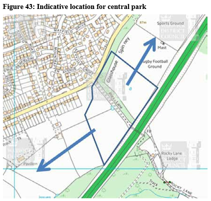
Outdoor sport and recreation – A Multi-Use Games Area shall be provided within the centrally located public park to meet the needs of the Local Community. Within H40, a purpose built BMX/ Mountain Bike facility shall be provided by developers of that land to afford alternative facilities for bikers currently using land within the Scheduled Monument. Community use of primary and secondary school sports halls and external playing pitches will be encouraged and supported by Warwick District Council. Contributions will be required towards further off-site sports and leisure facilities.
Other Open Space and Green Corridors – If the central park is 8 hectares, there will still be a requirement to accommodate c.11.6 hectares of public accessible open space within and across the entire site. A significant proportion of this should create green corridors linked to the central park enabling residents to walk or cycle through the development unfettered by vehicular traffic. The corridors should link to on-site community facilities (primary school, Local Centre and community facilities) and to the new employment site, enabling the central park to act as a magnet for pre- school and after school activities and a potential destination for employees during lunch breaks (or similar). They would further help to encourage local use of sustainable modes of transport.
The green corridors should be imaginatively designed, offering opportunities for equipped and natural play, meeting places (i.e. seating areas) and potentially incorporate well designed SuDS. They should also include outdoor gym equipment or other exercise/activity/fitness trails to encourage health and wellbeing.
Soft, green edges to the development site will be desirable and key gateways into the site (i.e the junctions from Leamington Road, Glasshouse Lane and Crewe Lane) shall be characterised by planting, immediately giving the development a green character and appearance as you enter the site.
Throughout the site, there will be a need for several play areas to ensure no resident is more than 480 metres from a suitably equipped area of play.
Allotments – For any development of 100 or more dwellings, the Open Space SPD requires on- site allotment provision. This could generate multiple allotment sites across the area, which could be impracticable and an inefficient use of land. Each allotment site would need vehicular access, parking and turning areas with a mains water supply and a secure building for storage. It would be preferable that one or if necessary two allotment sites are provided and that the plots are half of the traditional size, i.e. 125m2 rather than 250m2. This would permit more people to enjoy an allotment plot. Based on 1,400 dwellings a total area of 1.6 hectares is required for allotment land.
It is understood from Kenilworth Town Council that at the time of writing there is currently a demand for 70 additional plots. Whilst this development should not seek to redress the shortfall, it should not add to it.
Developers should approach the Town Council to ascertain whether they would be willing to undertake the future management of these new allotments. If not, developers should confirm how they are to be managed in the future.
Management Plans – Management plans will be required for each development site/open space to identify how each is to be maintained in the short term during establishment and in the long term to ensure viability of the space for the life time of the development. This is a key criteria of the Green Flag Award.
The Council will require developers to offer open spaces to be adopted by the Council when completed with a maintenance sum. This shall be included in relevant s106 Agreements or similar legal obligations. The Council will require a Royal Society for the Prevention of Accidents (RoSPA) report to be provided to confirm that the open spaces and play areas have been laid out in accordance with the approved plans.
Planting – It is important that all green space is safe and welcoming and the choice of planting is critical in this regard.
Along the green corridors, planting should be well managed, with ultimate growing heights being naturally low to retain good sight lines; and tree canopies should be maintained high. Weeping tree species should be avoided.
Planting should benefit wildlife, including not exclusively, birds, bats and reptiles. It is not necessary for all planting to be native because many cultivated species can benefit wildlife and can extend the season beyond natives, where that is early or late source of nectar, berries or places to nest or hibernate.
Planting plans should identify how their chosen schedule benefits wildlife to ensure a good range is selected. Wildlife benefit should be at the fore of decisions; however there will be occasions when other environmental factors require other varieties to be considered or where ornamental varieties are more appropriate to a design. The rationale behind plant selections should be made clear and it should be demonstrated that wildlife benefits overall. Native planting where used should be of local provenance that suits the landscape characteristics of the area.
Sustainable Drainage – Sustainable Urban Drainage Systems (SuDS) imaginatively designed can be multi-functional spaces, reducing the adverse impacts of traditional surface water systems and provide an opportunity to combine surface water management with green space affording benefits for amenity, wildlife and recreation.
Warwick District Council's approach is to adopt SuDS where they are located within areas of open space, with a commuted sum. Through a Service Level Agreement with Warwickshire County Council's Flood Risk Management, SuDS designs are checked and approved before implementation.
Applicants/developers will be expected to enter into a s106 agreement or similar planning obligation requiring:
- a management plan to be provided detailing how the system is to be maintained for the life-term of the development; and who will adopt which features. For example, the property owner, a utility company, County Council or the District Council.
- Written confirmation from an independent expert in the field, with appropriate insurance, that post installation, the as built features are (i) built in accordance with the approved plan or (ii) if there is variance, identify the variance and confirm that the feature(s) as built fulfil the requirements of the approved scheme (iii) are safe. A RoSPA report will be required.
Permanent wet SuDs features can be particularly beneficial to wildlife and aesthetically pleasing if designed well but they should not be placed adjacent to play areas where they pose a risk to health and safety. SuDS should be designed to maximise their value for biodiversity and hold standing water for the majority of the year if possible.
Ecology and Biodiversity – The site benefits from many landscape characteristics and features that create suitable habitat for wildlife including protected species. Areas of high ecological value include woodland areas, orchards, watercourses and field boundary hedgerows.
There are three designated Local Wildlife Sites of nature conservation importance within the site, Glasshouse Spinney, Thickthorn Wood and River Avon. The River Avon Local Wildlife Site relates to the watercourse within the H40 allocation which connects to the River Avon further to the east.
Biodiversity Impact Assessments will be expected to be provided for each site that comes forward to assess the impact of development on biodiversity based on the proposed habitat creation,
enhancement and management on site and to determine whether habitat loss can be compensated through on-site habitat provision or whether a biodiversity offsetting scheme will be required. It is recommended that habitat loss is minimised and where it is unavoidable replacement on-site habitat will be preferable. Ecological Management Plans will also be required at the detailed planning stage.
Bat surveys shall be undertaken prior to the demolition of any on-site buildings and other protected species surveys shall be carried out where applicable relating to Breeding Birds, Badgers, Reptiles, Otter and Water Voles and Great Crested Newts. Appropriate mitigation shall be provided should any habitats be affected by development.
Green spaces shall be connected where possible to provide wildlife corridors and a buffer of at least 15m shall be retained between built development and woodland parcels and orchards to protect existing habitats. Lighting within the development near sensitive areas including woodland and hedgerows should be designed to provide a safe environment for the community yet minimise harm to commuting/foraging wildlife corridors.
Development Principle 5A: Delivery of green infrastructure, play and recreation provision
Greenspace shall be provided on site in accordance with the following principles:
- Greenspace shall be provided within all development sites in accordance with the size and type of greenspace set out in the Council's adopted Green Space. Where developers contribute a proportion of their requirement towards the Central Park less greenspace a proportionate reduction in greenspace on their site will be permissible.
- Public open space and play provision to be provided within the site shall be of high quality and meet Warwick District Council's 2012 'Play Area Standard'. As part of meeting this quality standard the following five principles shall be applied:
- Play areas should be located where there is good natural surveillance from the street and neighbouring houses
- Play areas should be located on accessible green space where feasible and include elements of natural and free play
- A buffer zone should be provided around play areas
- All play areas should be designed to be inclusive for children and young people with disabilities
- Play areas should be designed using the 10 principles for designing successful play space as set out by Play England in their guidance manual 'Design for Play', which has been adopted by the Council.
- A large central park approximately 8ha in area and to be adopted by Warwick District Council shall be provided in the broad location of Figure 43. This shall include seating, natural green space, equipped and natural play opportunities for children and young people up to 18 years of age and additional space for informal ball games and shall include provision for cycle parking
- Green corridors shall be provided linking the central park to neighbouring residential areas and other on-site community facilities including the primary school, Local Centre, employment land and community centre.
- The green corridors and other footpaths and cycle routes to be provided within the site, other than those forming part of the spine road, shall be imaginatively designed offering opportunities for equipped and natural play, meeting places and potentially incorporate well designed SuDS. They should also include outdoor gym equipment or other exercise/activity/fitness trails
- Play areas shall be provided across the site to ensure no resident is more than 480 metres away from a suitably equipped area of play
- A BMX/Mountain Bike facility shall be provided within a suitable location within the H40 allocation in order to meet the needs of the community and offer an alternative facility for bikers to the undesirable use of land within the Scheduled Monument.
- Soft, green edges to the development site will be desirable and key gateways into the site (the junctions from Leamington Road, Glasshouse Lane and Crewe Lane) shall be characterised by landscaping and tree planting
- Two serviced allotment sites, distributed across the site, shall be provided to serve the whole of the east of Kenilworth site with the combined size meeting the Open Space SPD standard. Developers will all be expected to contribute towards the land and construction costs of two identified sites, one in H40 and one in H06
- Existing mature field boundary hedges shall be retained where possible within the layout
- Mature trees within high tree retention categories should be incorporated within the layout of development where possible and shall be protected throughout construction works. Existing trees subject to a Tree Preservation Order shall be retained unless the Local Planning Authority authorises their removal because the wider benefits of their removal outweigh their retention. Any mature trees to be removed within the site should be replaced with trees of an appropriate species and size in suitable locations
- Applications shall be accompanied with a Biodiversity Impact Assessment (BIA) and this shall set out measures to ensure that there is no overall loss to biodiversity. A long term ecological management plan will be required for sites at the detailed planning stage and developers of different parcels of land are urged to work collaboratively in an attempt to achieve Ecological Management Plans that cover larger parcels of land
- Varied planting shall be included throughout the development and species shall be chosen to benefit a range of wildlife
- Sustainable Drainage Systems (SuDS) shall be imaginatively designed into development providing benefits for amenity, wildlife and recreation.
(4) Protecting and responding to local heritage assets
Kenilworth is home to a significant number of heritage assets, although the main concentration of these is to the north west of the town around the Castle and High Street area.
The site does not include any listed buildings and is not within or adjacent to a conservation area. There are however four Grade II listed buildings near to the site, two separated from the site by the A46 (Bridge over Rocky Lane; Grecian Lodges) and two more closely related to the site in Thickthorn Manor and Stables at Thickthorn Manor, located to the south west.
Thickthorn Manor was once a three-storey farmhouse then in 1811 became a country mansion in mock-Tudor style with medieval battlements and turrets. It was remodelled and extended in 1987 and is now in use as a nursing home. The building is partially screened from the site by mature planting to the south and west of its grounds.
Thickthorn Stables, associated with Thickthorn Manor, is a cement-rendered two-storey battlemented structure with two side wings, complementing the architectural style of the main house. The stables were extended and converted into apartments in the 1980s. Thickthorn Orchards, a cul-de-sac comprising residential bungalows, provides some screening of the building and a buffer from the development site. In order to respect the setting of these listed buildings it is recommended that the design and scale of buildings in the vicinity is sensitive to the present visual context of the buildings.
A Scheduled Monument spans part of the north eastern end of the site. The monument relates to a Romano-British settlement dating from the 1st-4th centuries AD with later evidence of medieval woodland management and post-medieval glass working. The name 'Glasshouse Wood' is believed to derive from glass working in the area during the late medieval and
post-medieval periods. The Scheduled Monument is considered to be a good example of a Romano-British settlement that survives well in the form of earthworks and buried archaeological features. The archaeological potential of the site is high with further archaeological investigation likely to facilitate further studies of Romano-British settlement patterns and land use in the
area and it will provide evidence for post-medieval glass working will contribute significantly to the study of this industry. The remains of the medieval and post-medieval glassworks are located within the north-western part of Glasshouse Wood and are unexcavated.
The Scheduled Monument comprises both woodland and open grassland with mature trees/ hedgerows along its perimeter. Damage has occurred in recent years within Glasshouse Wood adjacent to the public footpath within the site through the construction of jumps for mountain/BMX bikes. As a result the site has been included in English Heritage's register of 'Heritage at Risk' where it is described as 'Generally satisfactory but with significant localised problems'. The development provides an opportunity to address these issues of digging within the Scheduled Monument and address potential causes including ignorance of the site's designated status and the susceptibility of the historic environment to such activity. Applicants of land within or adjoining the Scheduled Monument will be required to undertake measures to attempt to address the causes of the damage including provision of recreational BMX/mountain biking facilities, restoration of the damaged area and provision of suitable interpretation within the development to explain the history and significance of the site.
There is a presumption in favour against development upon Scheduled Monuments and it is recommended that the Scheduled area is used as public open space involving no or minimal ground disturbance. Development near to the area will be required to respect its setting.
Other than fieldwork undertaken along the line of the A46 prior to its construction in the early 1970s, there has been little in the way of systematic fieldwork undertaken within the site.
There is considered to be a Moderate chance of deposits of Roman or earlier date being present within the site and low to moderate chance of medieval or later features awaiting discovery. However, there is notable potential for the discovery of further more recent archaeological sites within the Development Brief site. The Glasshouse Wood settlement may not have been isolated and other farmsteads/settlements may have been present in the vicinity. Furthermore, as evidence indicates the probability that the post-medieval glass house was situated within or close to the southern edge of the Scheduled Area, land immediately south of the Scheduled Area, west of the A46, should be appropriately evaluated by trial-trenching to ascertain the nature, extent, state of preservation and significance of any surviving deposits and a suitable programme of further mitigation. Further interpretation material could be provided should the evaluation result in interesting findings.
Stoneleigh Park Grade II* Listed Park & Garden is located to the eastern side of the A46 and spans much of the vertical length of the site. Created on the site of a medieval abbey, Stoneleigh has an early 19th-century landscape garden and park covering around 365 hectares. The A46 ensures that there is not any physical impact from the development. However, inter-visibility between the site and the Designated landscape must be considered in any development proposals on site and the scale of buildings should reduce on land close to the eastern edge of the site in any locations where the effects may be most apparent, including the central parcel of land between Thickthorn Wood and Glasshouse Wood. Street lighting designed to minimise light pollution and enhancements to the existing tree screening along the western side of the A46 are both recommended to minimise any impact upon this heritage asset.
Glasshouse Spinney, a tree belt cutting across central areas of the site, represents remnants of the western limit of Stoneleigh Park and along with other factors, including its ecological status and the presence of two public footpaths, is a further reason to retain this land. It is recommended that development of surrounding land ensures minimal harm to the Spinney.
Development Principle 5B: Heritage
- All applications within the site shall include a detailed Heritage Statement to consider the impacts of the development and any resulting benefit, loss or harm to the significance of any nearby designated heritage asset(s). The assessment shall consider both visual impact as well as impact from other factors such as light and noise and where applicable the change to the character of the historic landscape must also be considered;
- Applications relating to land within or immediately adjoining the Scheduled Monument shall:
- maximise opportunities for access to the Scheduled Monument;
- provide for interpretation material within and to the edge of the Scheduled Monument;
- include a Design and Management Plan setting out: measures to reinstate land which has been damaged by mountain/BMX bikes; measures to minimise future harm to the Scheduled Monument; details of any paraphernalia that may be proposed (such as bins, benches or lighting) in the area; details of access and paths across the area and details of landscaping. The Plan shall include an assessment of the benefits and harm of such works;
- demonstrate that the scale, design and location of development adjacent to the site will not result in significant harm to the heritage asset;
- Development adjacent to the Scheduled Monument shall front onto the Scheduled Monument where possible to assist in providing natural surveillance and a self-policing environment;
- A green buffer shall separate the new development and Glasshouse Wood protecting the rural setting of the Scheduled Monument;
- No earthworks shall be carried out within the designated area of the Scheduled Monument, other than to ameliorate past damage or to improve paths through the area, and any works shall first be agreed with Historic England.
- Any physical acoustic screening in the vicinity of the Scheduled Monument should abut the duel carriageway, where possible, and should not visually obscure large areas of the Scheduled Monument from public view to assist in self-policing;
- Development near to Thickthorn Manor and Stables shall ensure that the setting of the listed buildings is not harmed and where possible views of Thickthorn Manor from the roundabout over the dual carriageway shall be maintained and reinforced.
- Development proposals shall ensure inter-visibility between the site and the Grade II* Registered Park at Stoneleigh Abbey is considered and the scale of buildings shall reduce on land close to the eastern edge of the site in any locations where the effects may be most apparent. Street lighting designed to minimise light pollution and enhancements to the existing tree screening along the western side of the A46 are both recommended to minimise any impact upon this heritage asset.
- Opportunities shall be taken to maximise opportunities to enhance the wider setting of the Grade II* Registered Park at Stoneleigh Abbey
- All outline or full applications shall be accompanied by a detailed archaeology assessment and where appropriate developments will be expected to follow a programme of archaeological work in accordance with a written scheme of investigation.
(2) Noise, Air Quality and Contaminated Land
It is of critical importance to the success of the creation of the new community that a satisfactory living environment is created for residents and that the impact of the development upon the environment is minimal.
Whilst the historic use of the site does not suggest a likelihood of any significant contamination, every parcel of land will require appropriate investigations to determine whether the
land presents a risk of contamination to site users. An initial desk study and a preliminary ground investigation will be required for all sites with further investigation required as necessary. Appropriate mitigation measures shall be identified where applicable.
The site is boarded on the eastern side by the A46, to the west by Glasshouse Lane and to the south by Leamington Road. Consideration will need to be given to the impact of road traffic noise on the future residents and users of the site.
In particular, noise from the A46 will need to be carefully considered and a buffer zone to protect residential amenity and some of the road traffic noise arising from the A46 is likely to be required but alternative forms of mitigation will also be considered. Good acoustic design to minimise noise impacts on the new dwellings will be required and could include maximising the spatial separation between the noise source and the new dwellings, implementing means of screening the dwellings from the noise source, i.e. fencing, bunding, using the site layout
to reduce noise propagation across the site, i.e. using blocks of housing as barriers/screens, designing the internal layouts of the houses to have non-habitable rooms nearest to the noise source and locate the most sensitive rooms away from the noise source, and/or ensure that the building fabric is designed to protect residents from elevated levels of noise, i.e. glazing and ventilation specifications. It may be advantageous to locate open spaces nearest to the site boundary to maximise the separating distance between new houses and the A46.
A noise survey shall be undertaken early on in the design process of each site to ensure that good acoustic design decisions are taken which enable residents to enjoy suitable noise levels with open windows, by careful site massing, and considering building location, orientation, internal layouts and mitigation.
It is important that the noise impact of any commercial elements of the site on residential dwellings is fully addressed in the design and layout.
Air quality will be an important consideration for this large development and applicants must refer to Warwick District Council's low emission strategy to evaluate the air quality impacts of the proposed development. Particularly given the relationship of the site to the A46, applications will need to demonstrate that new residents will experience acceptable air quality without the need for mechanical ventilation except in exceptional cases and development shall seek to minimise further pollution.
Development Principle 5C: Noise
New development shall ensure the amenity of nearby uses and residents and provides acceptable standards of amenity for future users and occupiers of the development. Applicants shall demonstrate that:
- Road traffic noise emanating from the A46 and from neighbouring roads including Glasshouse Lane and Leamington Road is fully taken into consideration and that the recommended indoor and outdoor noise levels can be achieved in accordance with BS8233:2014 and the World Health Organisation (WHO) guidelines for community noise (1999).
- Full details of proposed mitigation measures relating to mitigating A46 noise, where applicable, shall be submitted as part of a planning application. Detailed consideration shall be given to the financial viability of the solution, its acoustic effectiveness, its appearance and impact upon any heritage assets in the area.
- Consideration shall be given to noise impacts from the additional vehicle movements generated by the proposed development (considering the cumulative impact of proposed development) and whether this will have adverse noise impacts on existing nearby residential dwellings or on proposed new dwellings.
- Applicants will be required to demonstrate that noise from rail traffic on the proposed High Speed Rail 2 (HS2) route has been considered, and where relevant, highlight any mitigation measures required.
- Where reasonably practicable, units on the employment allocation shall be designed and orientated to act as a noise barrier to the A46 and B2 (General Industrial) uses shall be suitably separated from existing and proposed residential properties through either the presence of B1 (Business) units in between or through substantial landscaping and where necessary acoustic barriers. The applicant will need to undertake a noise assessment in accordance with BS4142:2014 to consider the potential noise impacts from operational noise at the proposed employment land (relevant to the appropriate use classes and operating hours), any plant noise that is likely to be created, and noise from delivery vehicles or other vehicular movements.
- Careful consideration shall be given to the interaction between existing and proposed residential dwellings and proposed primary and secondary schools on the site, particularly with regards to outdoor recreational areas and sports fields. Measures including maximising the separation distance between noise sources and receptors and utilising screening should be considered where necessary. If sports pitches are to be located in close proximity to housing, the applicant may need to undertake a noise assessment to consider the potential impacts. Operational controls may also be appropriate, i.e. restricting the use of outdoor sports pitches during unsocial hours.
- Full consideration shall be given to noise associated with the Local Centre or community facilities including noise from plant and noise breakout and where necessary mitigation shall be proposed to protect the amenity of nearby residential dwellings.
Development Principle 5D: Air Quality
New development shall be designed to ensure that proposed residents experience an acceptable living environment through suitable air quality and new developments shall seek to minimise the generation of significant air pollution.
Proposals shall adhere to the following:
- Detailed Air Quality assessments shall accompany all major planning applications to demonstrate that existing sources of air pollution will not have a detrimental impact upon the amenity of proposed residents. All assessments shall refer to Warwick District Council's Air Quality & Planning SPD (August 2018) (Consultation Draft) or any subsequently adopted version of the document and mitigation measures shall be identified and provided in accordance with the document or any subsequently adopted SPD relating to air quality. In particular, given the proximity of the development to the A46, the air quality assessment will need to consider the air quality impacts from the A46 on the new residential receptors and will involve air quality monitoring at locations near to the A46. This is typically done via the use of diffusion tubes and we would expect at least six months of monitoring to be conducted but ideally 12 months wherever possible.
- The air quality impacts of the proposed development itself on existing residential dwellings and local air quality will also need to be considered in air quality assessments, including the impacts on nearby air quality management areas.
- Given the overall quantum of development proposed, there should also be a consideration of the cumulative air quality impacts from the proposed developments. As the development land is so close to the A46, there is a strong possibility that a large separation distance between the boundary and residential properties will be needed, therefore the use of air quality monitoring data will be essential in the design stage.
Development Principle 5E: Ground Contamination
- For all areas of the site, appropriate investigations shall be undertaken to determine whether the land presents a risk of contamination to site users, including risks to human health, groundwater and surface waters (on and off site), and risks arising from ground gases. The investigation will typically progress in a phased approach including an initial desk study and a preliminary ground investigation (Phase I), followed by further investigation (Phase II) if identified as being necessary. Where necessary, appropriate mitigation measures will be required.
(2) Flood Risk
The site is located entirely within Flood Zone 1 and therefore is at low risk of fluvial flooding (land assessed as having a less than 1 in 1,000 annual probability of river or sea flooding <0.1%). Owing to the topography of the site which slopes down west-east and north-south towards the A46 and two watercourses within the site, there are areas around the watercourses which are susceptible
to surface water flooding. The site is not located within a Groundwater Source Protection Zone.
Sustainable Drainage Systems will be required within the development to manage surface water in a sustainable manner to greenfield run off rates. Particular attention should be paid to the management of drainage in areas known to be susceptible to surface water flooding
Development Principle 5F: Flood Risk
a) Development shall be laid out in such a way to minimise the risk of flooding on or off site and shall provide for appropriate Sustainable Drainage Systems (SuDS) in suitable locations.
(2) Health
Development Principle 6: Promoting a healthy community
Relevant Local Plan policies: HS1 'Healthy, Safe and Inclusive Communities; HS6 'Creating Healthy Communities', SC0 'Sustainable Communities', BE1 'Layout and design'
Health is an important consideration in planning for new
development. The creation of an attractive living environment
and the ability to easily access services needed and the
promotion of walking and cycling are considered to be essential
in establishing a successful and healthy community.
It is important to ensure that all new residents have suitable access to primary care facilities. South Warwickshire Clinical Commissioning Group (SWCCG) has assessed capacity and concluded that the quantum of development and capacity of the two existing GP surgeries near to Kenilworth town centre does not justify the provision of a new health centre to serve new residents. However, there is likely to be a need for some enhancements to the existing surgeries and therefore applicants are likely to be requested to contribute towards these enhancements through section 106 funding.
The provision of a Community Centre and the design of the Local Centre and greenspaces have the ability to promote community cohesion and help reduce isolation, thus improving public health. Allotments provide the opportunities for a degree of self-sufficiency and also afford further opportunities for community integration.
Community facilities including Local Centres, community centres and parks and play areas shall be located within walking distance of new residential dwellings and the layout of development shall strongly encourage walking and cycling both within the development and through improved connectivity with the existing town.
To promote public health and well-being, development should align with Building for Life 12 principles. These principles form the basis of Warwickshire County Council's draft guidance document 'Public Health Evidence for Planning and Developers' which sets out detailed guidance to promote the creation of a healthy community.
Developers are encouraged to engage with the NHS's Healthy New Towns programme to promote the creation of a healthy community. It is anticipated that further guidance on this programme will be issued in 2019.
Development Principle 6: Promoting a healthy community
- Developers will be expected to contribute towards improvements to existing healthcare facilities in the town as necessary to ensure that existing facilities have the capacity to meet the additional demand resulting from the development.
- Applications will be expected to demonstrate within a supporting statement that they are broadly in accordance with principles relating to health set out in 'Building for Life 12' and Warwickshire County Council's documents 'Public Health Evidence for Planning and Developers' (draft) and 'Neighbourhood Development Planning for Health'.
- Community facilities shall be provided within the development including a Local Centre, community centre, parks and play areas and public meeting areas and these shall be easily accessible on foot and by cycle.
(2) Objective 7: Creating a high quality designed urbanenvironment
Relevant Local Plan Policies: BE1 'Layout and design', BE3 'Amenity', HS1 'Healthy, Safe and Inclusive Communities', HS4 'Improvements to Open Space, Sport and Recreation Facilities', CC2 'Planning
for Renewable Energy and Low Carbon Generation'; CC3 'Building Standards and other Sustainability Requirements'
Land East of Kenilworth shall be designed as a new community that is well integrated with the existing town and is defined by a strong sense of identity, characterised by its network of connected green spaces, attractive public spaces, legible streets, high quality designed buildings and its community facilities that meet the needs of the whole community. It will be a community where cycling and walking as a means of travel will be desirable.
The development should respect and acknowledge the character of the existing town and its prevailing characteristics whilst having the ability to introduce innovative and visually stimulating design to give the new development a unique character and identity. Building materials should largely reflect the local vernacular and materials typical within the Ancient Arden character area with some flexibility to introduce some alternative building materials to assist in creating a unique character for the development.
Dwellings shall be varied in their design and appearance and shall include interesting architectural features. Buildings shall not be designed in isolation but should have an appropriate relationship with nearby streets and spaces.
Where possible and appropriate, low carbon and renewable energy technologies should be integrated into the development promoting sustainability and properties should be designed with features including water efficient fittings to help achieve a lower water consumption than the maximum volume specified in the Building Regulations and it is recommended that properties are
built to the optional requirement in Building Regulations of 110 litres of water per person per day.
Care shall be given to ensure that appropriate storage spaces are created within residential and commercial development to ensure waste bins are not a dominant and permanent feature in the streetscene. Innovative solutions to waste storage, such as underground storage will be encouraged.
Detailed design and placemaking principles, street typologies, building materials and boundary treatments and public art principles are set out in the remainder of this section. Developments will be expected to conform to the guidance contained within those sections.
(3) Placemaking Principles
The Neighbourhood Level analysis identified qualities to guide the design principles for the site. These included that buildings often have an intimate and close relationship to one another as well as the street. Building plots and architectural styles vary from street to street creating places and streets with interest and character. Often two storey terraced cottage sit cheek by jowl with three storey town houses. Locally available building materials such as red brick, render or timber provide a common theme creating a strong sense of place and identity. In order to replicate some of these intrinsic qualities the following principles should be applied to new residential development on the site:
- Vary the width of building plots particularly within local centres;
- Different block sizes should be applied to create further interest;
- Different house types such as terraces, town houses, terraced cottages, detached and semi-detached properties should be used to create interest;
- Street geometry should vary as it passes through the site. Street width will alter as a result of street hierarchy and its design speed of streets should be reduced in the local centre;
- Buildings should not be located at a uniform distance from the street but should vary to create an interesting streetscape and public realm; and
- Building heights should vary.
A number of more general principles have been developed to inform the indicative masterplan contained within this SPD and developers will be expected to consider them when designing proposals for parcels of land within the overall site. These principles are expected to be followed by developers and combined will help achieve sustainable development:
Development Principle 7A: Placemaking Principles
- All development will be expected to adhere to a range of placemaking principles as set out below:
Overarching
- Creation of a high quality, safe, inclusive and attractive place that has unique features yet is fully integrated into the existing town
- Provision of a mix of uses including residential, employment, education and retail/service uses to provide a community with access to good quality homes, employment opportunities and services to meet day-to-day needs
- Provision of community facilities to assist in creating a sense of community cohesion
Healthy community
- Creation of a healthy community through quality access and opportunities for walking and cycling, good access to healthcare facilities, restrictions on hot- food takeaway outlets, provision of a range of areas to play and supporting improvements to existing leisure and recreation facilities in the local area
Sense of Place
- Utilise and respect existing site features and relevant off-site features within the layout to deliver a development that respects the natural environment
- Incorporate building materials and features that are characteristic of the local vernacular
- Create welcoming gateways into the site and the Local Centre providing a sense of arrival
Urban Form
- Creation of a legible and diverse urban environment through setting out a hierarchy of streets
- High quality buildings to enclose space
Connectivity and movement
- A layout that promotes sustainable travel
- Creation of attractive streets that meet the needs of all users – pedestrians, cyclists, cars/other vehicles and public transport
- Delivery of public transport services meeting the daily needs of residents and workers
- All homes and places of work to be within 400m walk of a bus stop
- Improved cycle and pedestrian connectivity between the site and the existing town
- Integrate and connect the development with existing public footpaths
- Ensure good quality roads within the development and delivery of off-site improvements to connect the development to proposed employment and education facilities and to existing destinations within the town
Car and Cycle Parking
- Provision of secure, covered cycle parking in suitable locations near to the entrance of places of work, homes and community facilities in accordance with locally adopted guidance to encourage the use of this mode of transport
- Provision of suitable levels of parking for dwellings, employment areas and retail/service uses in accordance with locally adopted guidance
- Ensure car parking is integral to the design of dwellings, streets and spaces
Mix of High Quality Homes
- Provision of high quality dwellings to meet the varying needs of the community
- Creation of a balanced community through the construction of homes of different types, sizes and tenures including provision of affordable housing, open market housing and self-build homes
- Ensure a mix of dwelling types, size and tenures across the entire site creating a 'tenure blind' development
- Delivery of dwellings which are of sufficient size to enable adaption by occupiers throughout their lifetime
- Strive to achieve a Building for Life Accreditation through designing new homes in the context of Building for Life 12 Criteria (2012) (See Table 4).
Education/Local Centre/Community Facilities
- Provision of high quality education facilities to meet the needs of residents of the new development (and existing town)
- Creation of a visually attractive and vibrant Local Centre easily accessible by safe and suitably lit walking and cycling routes that are appropriately connected to the new residential and employment areas across the site
- The Local Centre shall operate as a community hub and provide attractive public realm space suitable of sufficient size to create a meeting place and support community events
- Provision of a new community centre and external space
Biodiversity, Ecology and Greenspaces
- Protect existing on-site features that provide good habitat for protected species (including woodland, water bodies and hedgerows)
- Encourage biodiversity through the creation of new habitat, connecting existing habitats
- Minimise impact upon protected species and where it is unavoidable to avoid harm to their habitat, re-provide suitable habitat on site
- Utilise existing woodland and green areas on site within the greenspace strategy for the new development
- Provision of additional greenspaces to connect with existing greenspaces
- Provision of a large central park to serve the needs of the community with green corridors linking this to other infrastructure
- Incorporate sustainable drainage solutions within green space
Design
- Strive to accord with guidance contained in Warwick District Council's Garden Towns, Villages and Suburbs document (May 2012)
- High quality built environment including buildings, public realm and public open spaces
- Creation of an external environment that is accessible to all
- Use of sustainable construction materials and construction of energy efficient buildings, utilising zero-carbon or renewable energy technology where applicable
- Respect the architecture and building materials of the local vernacular. However, where suitable, explore opportunities for innovative design that helps create a unique development
- Minimise waste material leaving the site and new material having to be delivered to the site
- Provision of suitable and discreet on-plot facilities for refuse storage
- Provision of high quality boundary treatment to properties
Safety and Security
- Design buildings and streets to provide natural surveillance over public open space and footpaths/cycleways
- Create well-lit and appropriately surfaced footpaths/cycleways within the site
- Without compromising the aesthetics of the development, where possible aim to achieve Secured by Design Accreditation
Management and Maintenance
- Creation of management and maintenance strategies to ensure that the quality of development remains. This includes management of public open spaces, play areas and recreation facilities, community centre and sustainable drainage features.
Table 4: Building for Life 12 Criteria
|
Integrating into the neighbourhood |
||
|
1 |
Connections |
Does the scheme integrate into its surroundings by reinforcing existing connections and creating new ones, while also respecting existing buildings and land uses around the development site? |
|
2 |
Facilities and services |
Does the development provide (or is it close to) community facilities, such as shops, schools, workplaces, parks, play areas, pubs and cafés? |
|
3 |
Public transport |
Does the scheme have good access to public transport to help reduce car dependency? |
|
4 |
Meeting local housing requirements |
Does the development have a mix of housing types and tenures that suit local requirements? |
|
Creating a place |
||
|
5 |
Character |
Does the scheme create a place with a locally inspired or otherwise distinctive character? |
|
6 |
Working with the site and its context |
Does the scheme take advantage of existing topography, landscape features (including water courses), wildlife habitats, existing buildings, site orientation and microclimate? |
|
7 |
Creating well defined streets and spaces |
Are buildings designed and positioned with landscaping to define and enhance streets and spaces and are buildings designed to turn street corners well? |
|
8 |
Easy to find your way around |
Is the development designed to make it easy to find your way around? |
|
Streets and home |
||
|
9 |
Streets for all |
Are streets designed in a way that encourage low vehicle speeds and allow them to function as social spaces? |
|
10 |
Car parking |
Is resident and visitor parking sufficient and well integrated so that it does not dominate the street? |
|
11 |
Public and private spaces |
Will public and private spaces be clearly defined and designed to have appropriate access and be able to be well managed and safe in use? |
|
12 |
External storage and amenity space |
Is there adequate external storage space for bins and recycling, as well as vehicles and cycles? |
(1) Street Typologies and Street Level Design Principles
The relationship that the new streets have with one another and to the built form will have a significant impact on the character of new development on land East of Kenilworth. Streets should be designed as high quality, low speed pedestrian and cycle friendly environments with a clear hierarchy.
Following the Neighbourhood Level Analysis work undertaken by LUC, a number of different street typologies have been identified. These street typologies have been informed in part by the characteristics of the streets analysed and will provide design principles for the new housing within the site. The design principles will help new development reflect the intrinsic qualities found in Kenilworth's streets and help create a strong identity and sense of place.
Main Street
- Spine road as it passes through or adjacent to the Local Centre providing access to local shops and services
- Provision of both short and long stay parking
- Parking integrated well into the street scene
- Generous pavement widths to allow building uses to spill out on to the pavement
- Street trees a dominant feature of the street
- Variety of architectural styles forming a continuous built edge
- Variety of building heights and plot sizes creating interest
Primary Route/Spine Road
- Main route through new residential development
- More generous street proportions including road and pavement widths
- Both on-plot and street parking
- Boulevard trees help to define the route
- Buildings continue to define the street and front onto it
- Strong definition between public and private space created by formal boundary treatments
- Front gardens and garden vegetation create a more open green environment
- Variety of plot sizes to create interest and diversity
Urban Streets
- Intimate side streets adjacent to the Local Centre
- Limited on-street parking
- Strong relationship between buildings on the street
- Variety of architectural styles forming a continuous built edge
- Small or no front gardens
- Variety of building heights creating a varied roof scape
Secondary Routes
- Buildings define the street and front onto it providing natural surveillance
- Variety of plot sizes to create interest
- Small front gardens
- Garden vegetation a dominant feature of the street
- Boundary treatments more informal such as hedges
- On-plot and on-street parking
- Secondary routes off the main spine road
Lanes
- Development often on one side of the street only
- Treatment for more peripheral areas of development are often adjacent to the countryside or green open space
- Boundary vegetation and trees a key feature of the road
- Housing less dense than in other areas and typically detached and semi-detached properties
- Buildings set further back from the street
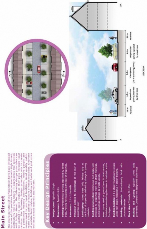 Figure 44: Street level design principles – Main Street
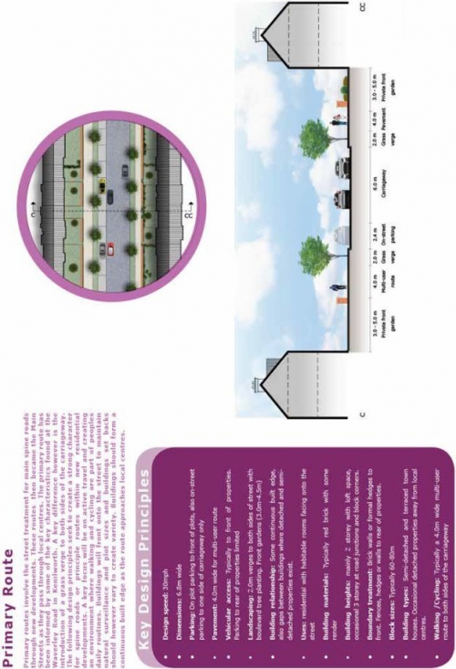 Figure 45: Street level design principles – Primary
Route
Figure 45: Street level design principles – Primary
Route 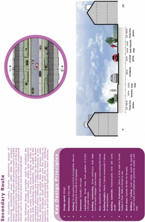 Figure 46: Street level design principles – Secondary
Route
Figure 46: Street level design principles – Secondary
Route
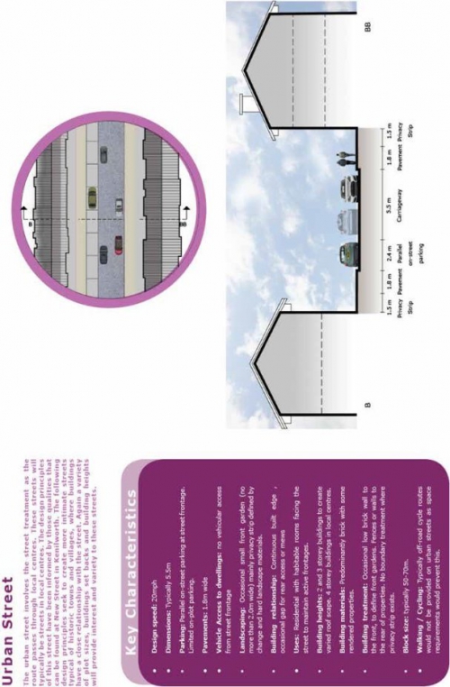
Figure 47: Street level design principles – Urban Street
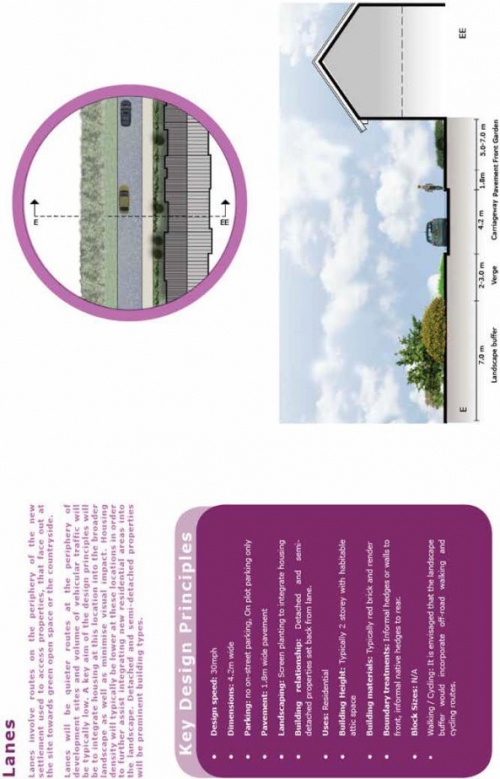
Figure 48: Street level design principles – Lanes
Development Principle 7B: Street Typologies
- Development within the site shall adhere to the street level design principles and key design principles of the street typologies set out in this section and applicants will be expected to demonstrate how their proposals conform to the typologies. Where there is robust justification for a variation in the street design, some variation may be acceptable.
The dominant building materials in Kenilworth are brick, render and to a lesser extent timber. The local brick is a distinctive red colour which provides a depth and warmth to the buildings. Local red sandstone is occasionally used to accompany the brick and is often used as door surrounds, window lintels and sills or for mullion windows. This local stone along with the brick helps to create identity and a sense of place. Roof tiles are typically red clay.
Whilst some variation will be acceptable to provide a variety within the new development, new residential and commercial properties constructed from brick should generally seek to match the warmth and depth of the brickwork found on existing properties in the town and look to utilise roof tiles of a similar colour to those typically found in the town.
Figure 49: Kenilworth Materiality
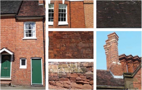
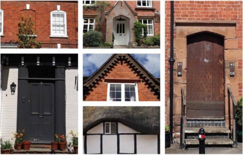
As highlighted below, there are a variety of boundary treatments found in Kenilworth depending on the age of the property and its location within Kenilworth. Georgian, Victorian and Edwardian properties near to the town centre tend to have low red brick walls to demarcate the front gardens and higher red brick walls at the rear of properties. Older properties at the edge of the town tend to have red sandstone walls. Hedges and fences also feature more towards the edge of the town and are often used as boundary treatments for larger detached and semi-detached properties.
Figure 50 below sets out appropriate types of boundary treatments adjacent to public highway or where the boundary treatment will be prominent from publicly accessible areas. Developers are expected to provide close-boarded timber fencing between adjoining rear gardens of residential properties.
Figure 50: Appropriate Boundary Treatments
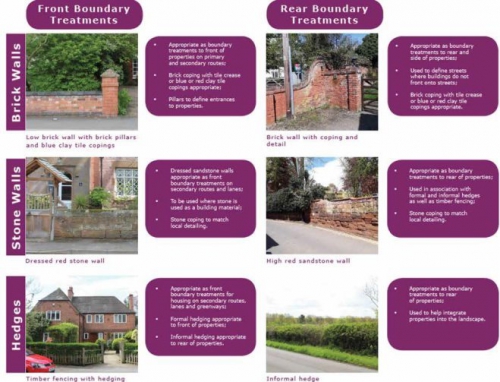
Development Principle 7C: Materiality and Boundary Treatments
- Development within the site shall predominantly utilise building materials that reflect the local vernacular and Ancient Arden character. However, flexibility will be supported to allow the introduction of alternative building materials in suitable locations where they have an appropriate appearance and relate well to the more traditional building materials and help create character and a unique identity.
- Boundary treatments to define plot edges within the development shall be varied and broadly in accordance with details set out in Figure 50. Timber fencing, without hedging, will not be supported as a boundary treatment to the edge of any plots for aesthetic and durability reasons.
The following principles should be applied for proposed parking in new residential areas within the site:
- Resident and visitor parking should be located so that it does not dominate the street scene. Street trees and landscape features should be used to break up long lengths of on-street parking bays. On-plot parking should be discreet and integrated into the street
- A mixture of parking solutions is encouraged
- On-street and on-plot parking should be convenient, accessible and as close to residential properties as possible. It should also be overlooked by habitable rooms which face onto the street. Where on-street parking is provided, it shall be broken-up by appropriate landscaping
- Whilst parking should typically be at the front or sides of properties to create active streets and promote natural surveillance and rear parking courts are discouraged there may be some exceptions or circumstances where parking at the rear of buildings is acceptable or necessary such as in places along the spine road where it is preferable to minimise the number of accesses. In these instances the parking should be overlooked, safe, convenient for users and protected by gated access
- All parking areas should be constructed from permeable paving unless it is deemed unsuitable
- Parking areas should conform to guidance stipulated within Warwick District Council's adopted Parking Standards SPD (2018).
The visuals in Figure 51 provide further guidance relating to car parking that should be followed by developers when preparing plans for the site:
Figure 51: Car Parking Principles
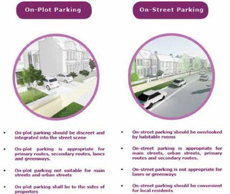
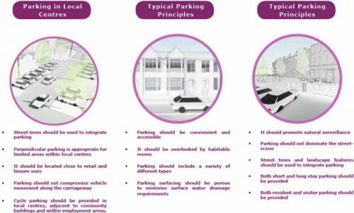
Development Principle 7D: Car Parking
- Development shall accord with the broad principles relating to car parking set out in this section along with guidance contained within the Parking Standards SPD (2018) and in Warwick District Council's Garden Towns, Villages and Suburbs document (2012).
(2) Incorporating high quality public art into thedevelopment
The Planning Policy Guidance which complements the National Planning Policy Framework and provides advice on how to deliver its policies states that 'Public art and sculpture can play an important role in making interesting and exciting places that people enjoy using." Objective B, Point 7 of Warwick District's Local Plan further highlights that developments should "be built to a high standard in terms of design, and provide inclusive, lively and attractive places where people feel safe and want to live, work and visit".
Warwick District Council is committed to high quality design and its continued support for arts and culture, which includes public art (work produced by artists within the natural or built environment). Arts and culture have an economic value, a positive impact on health and wellbeing and contribute to social capital and community cohesion within the district.
Warwick District has a long tradition of public art and there are many excellent examples of sculptures, commemorative statues and memorials throughout the area. The scale of development on this site creates opportunities for collaboration and provides the context and inspiration
for the commissioning of public art. Developers are encouraged to consider how they will incorporate public art and involve artists and makers from the pre-application stage. Warwick District Council's Arts Section and Planning Officers can provide advice in this regard.
Public art schemes should consider drawing inspiration from the heritage of Kenilworth. This could include:
- incorporating imagery, maps, poetry or text
- referencing Kenilworth's local history and providing interpretation
- creating permanent sculptures which represent historical figures or notable residents
- creating temporary or living artworks utilising rural / natural assets
- incorporating materials with links to Kenilworth such as red sandstone
Artists developing work based on this theme should be encouraged to undertake research into the history of Kenilworth, perhaps through accessing local archives or by consulting with English Heritage and collaborating with some of the areas local history groups.
Artists should consider how public art could assist with wayfaring and orientation at key locations throughout the development. This could include:
- functional artworks integrated into paving schemes, pathways or cycle routes
- the creation of bespoke 'trails'
- enhancing day-to-day pedestrian routes
- improving cohesion with other parts of the town or neighbouring developments
- using sculpture to create a defining landmark or provide an attractive focus / meeting point in open spaces
- lighting which could provide a welcoming, safe environment at night
- installation of street furniture such as carved wooden or stone seating
- landmark art that announces arrival into the development.
- interactive public art incorporating movement
- working with young people of the area to create and install work
- street / graffiti art
- incorporating public art into play parks and open spaces
- referencing links to education and learning
- incorporating digital elements
- highlighting the area's links to engineering and design.
Development Principle 7E: Public Art
The incorporation of public art into the new development will be supported and strongly encouraged. Proposals shall demonstrate that the following criteria have been considered:
- All major applications relating to the site shall include a scheme for the incorporation of high quality public art, to help deliver a successful residential environment and reinforce local and cultural identity. In addition to standalone, isolated projects public art should be incorporated into the development design as a whole wherever possible. Many of the essential elements that make up a building or landscape are often suitable or artistic interpretation. For example, entrances, cladding, doors, windows, lighting, signage, seating and paving areas can be individually commissioned to give developments a unique identity.
- In formulating a scheme for the incorporation of public art applicants are recommended to:
- Liaise with the Council's Arts Section and the Local Planning Authority at the pre-application stage;
- Devise and implement quality programmes of community participation and education as part of public art commissions. Warwick District Council strongly recommends that a clear process of artist led engagement with local stakeholders regarding public art is put in place in order to encourage understanding, ownership and civic pride; and
- Include artists in the masterplanning or design concept stage of developments wherever possible.
- Public art initiatives shall aim to be of the highest possible artistic merit and shall:
- Be of high quality, robust design and manufacture;
- Create interesting and exciting places;
- Increase public perception and interest in art and how artists work;
- Provide opportunities for artists to create original work and have it seen by large numbers of people.
Utilities
Objective 8: Delivery of
necessary utilities infrastructure to meet the needs of the
development
Relevant Local Plan policies: DS3 'Supporting
Sustainable Communities'; BE5 'Broadband Infrastructure'; FW1
'Reducing Flood Risk'; FW2 'Sustainable Drainage'; FW3 'Water
Efficiency'; FW4 'Water Supply'
Public Sewers/Water
There is limited sewerage infrastructure running into the site with plans indicating a 825mm diameter sewer running eastwards from Glasshouse Lane and discharging into the watercourse crossing the site. There do not appear to be any other foul or surface water sewer within the site or water mains.
Severn Trent Water has undertaken a hydraulic modelling sewer capacity development in the east of Kenilworth and have provided recommendations for this document.
Foul Water Drainage: The modelling found there to be a low impact on flooding to the existing network, meaning that the foul flows from the site can be routed through the existing system. As the land topography runs downhill towards the A46 flows from development at H40 and ED2 will not connect through a gravity connection, so will need to be pumped. Two pumping locations and two connection points are recommended by Severn Trent Water (connection points are A and B and pumping stations are orange triangles in Figure 53).
A high pollution risk has been found at Dalehouse Lane Terminal Pumping Station which requires additional storage to accommodate the development. A previous modelling study had identified that approximately 280 dwellings can be accommodated within the existing network before capacity improvements are likely to be required. A scheme will be promoted by Severn Trent to address this.
Surface Water: Under the terms of Section H of the Building Regulations 2000, the disposal of surface water by means of soakaways should be considered as the primary method. If these are found to be unsuitable, satisfactory evidence will need to be submitted. The evidence should be either percolation test results or by the submission of a statement from the SI consultant. If soakaways are not practical then discharge to a watercourse or a ditch should be explored. Where there is a watercourse on a site connection to public sewers will not be required. Subject to the above, Severn Trent Water expects all surface water from the development to be drained in a sustainable way to the nearest watercourse or land drainage channel, subject to the developer discussing all aspects of the development's surface water drainage with the Lead Local Flood Authority (LLFA). Any discharge rate to a watercourse or drainage ditch will be determined by the LLFA / Environment Agency.
Connections: For any new connections (including the re-use of existing connections) to the public sewerage system, the development will need to submit a Section 106 application form from Severn Trent Water's Developer Services department.
Figure 52: High Level Drainage Strategy, including connection points and risk to Dalehouse Lane Pumping Station (map provided by Severn Trent Water)
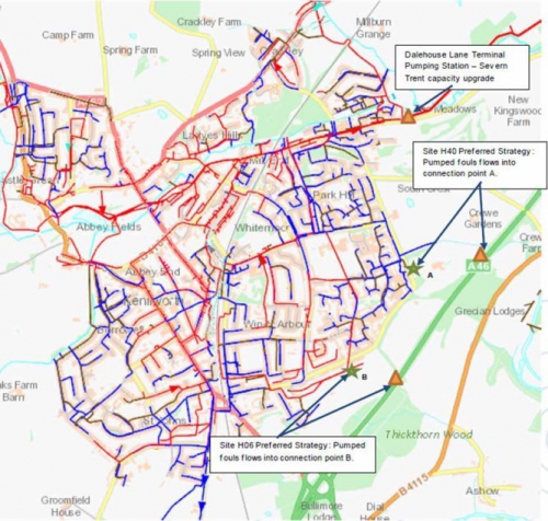
Electricity
Plans received from Western Power Distribution indicate that 11kV overhead high voltage electrical cables are present within the H40 allocation and a low voltage overhead cable is also present in this part of the site. Further underground cables are present in the H06 allocation, connecting to existing properties and a telecommunications mast. Developers within these areas of the site will need to liaise with Western Power around the diversion of electricity cables, where required.
Western Power Distribution has confirmed that the existing primary substation serving Kenilworth has limited capacity and would not be able to support the extent of growth on the site without improvement works. The substation can be upgraded to create capacity but any upgrade works will depend on factors including final load requirements, timings and network conditions before Western Power can determine suitability of upgrading the existing facility rather than provision of a new substation. Existing substations to the southern side of Coventry are considered to be too far away from the site to be suitable for any connections.
Where a new primary substation is required, ideally it should sit within the required load centre. Western Power have purchased land to the north eastern corner of the development site thus providing a site for a potential primary substation within the load centre should a new substation be required. Upstream reinforcement works to the Berkswell 132kV substation may also be required.
Within the site distribution substations, average size of 4x4m will also be required and shall be positioned in discreet locations away from living areas and boundary treatment can further minimise the visual impact of the substations.
Gas
Plans received from Cadent Gas relating to the site indicate that there are no gas mains crossing the site except for a low pressure main which crosses Glasshouse Lane and terminate within Glasshouse Spinney. Therefore, new infrastructure will be required on the site to connect to the existing network.
Telecommunications
British Telecom has apparatus in the form of both overhead lines and underground lines within the site. Given the limited number of buildings within the site, services are minimal across the site. Some Virgin Media equipment is also present in the area, including along Glasshouse Lane.
Development Principle 8: Utilities
- Developers are encouraged to enter into early pre-application discussions with all relevant utilities (electricity, gas, water and telecommunications) providers to confirm what infrastructure exists within their site and ensure that any relevant requirements of the infrastructure providers are incorporated into development proposals
- Developers, where relevant, shall liaise with Severn Trent Water with regards to providing pumping stations and other necessary infrastructure in locations as indicated on Figure 53 (connection points are A and B and pumping stations are orange triangles)
- Developers will be expected to contribute (directly to Severn Trent Water) towards capacity improvements at Dalehouse Lane Terminal Pumping Station
- The disposal of surface water by means of soakaways should be considered as the primary method of managing surface water. If it is demonstrated that these are unsuitable for the site then discharge to a watercourse or a ditch should be explored.
- Developers will be expected to contribute (directly to Western Power Distribution) towards improvements to the existing Kenilworth Primary Substation or an additional primary substation in the town and any necessary connection and upstream reinforcement works
- In order to ensure a visually attractive development, distribution substations shall be sited in locations that are not unduly prominent from roads, colour coated green and shall be positioned a minimum of 5m from any living areas (living rooms, kitchens, bedrooms) and include provision for a brick wall around the enclosure.