Land East of Kenilworth Development Brief
CHAPTER 8 - Shaping the Indicative Masterplan
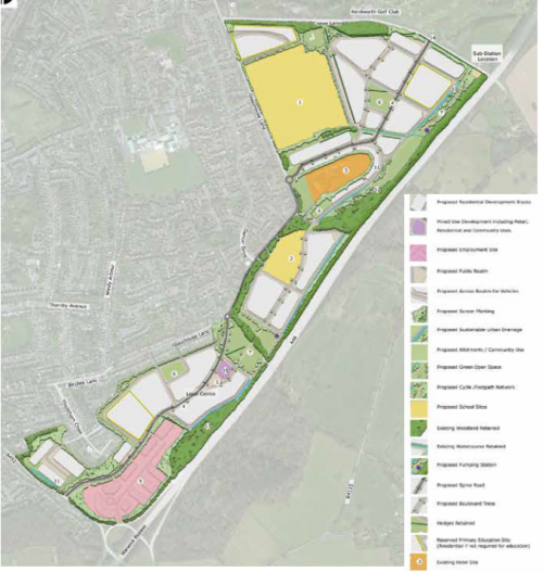
Masterplan Design Principles
In addition to the general design principles set out in Chapter 7, the following more specific design principles have informed the spatial arrangement of the Indicative Masterplan:
- Maintaining consistency with the Local Plan in terms of the location of residential, employment and educational uses within the site
- Retention and protection of valued landscapes and heritage assets such as the Scheduled Monument and ancient woodland
- Retention and enhancement of green infrastructure particularly peripheral planting areas
- Introduction of a spine road as the main primary route linking the residential and employment areas whilst avoiding destruction to the Glasshouse Spinney Local Wildlife Site, Glasshouse Wood and Rocky Lane public footpaths
- Ensuring that green open space and green infrastructure forms an integral part of the masterplan proposals and is dispersed evenly across the site
- Ensuring the necessary infrastructure to encourage walking and cycling as part of people's daily routine
- Connecting the site with the existing town and surrounding countryside
- Ensuring that the Local Centre and community facilities are within walking distance from main residential areas and centred around civic and public realm spaces
- Ensuring that proposed dwellings face directly on to adjacent streets to create active frontages and maximise natural surveillance
- Creating a clear hierarchy of connected streets to enhance legibility and wayfinding
- Siting residential areas within a woodland framework where housing density increases towards the main centres and decreases towards the periphery of the site
- Allowing for new development to create distinctive new communities and places which have been informed by the intrinsic qualities of Kenilworth's historic districts rather than simply creating an urban extension
- Reconciling the environmental, transport and historic constraints with the level of development outlined for the allocated sites
- Providing well connected green open spaces that are fully accessible. This includes a central green open space/park
Concept Plans
The following concept proposals drawings identify the thought process and broad principles that have shaped the Indicative Site Masterplan. The concept proposals have been developed in response to the site constraints and opportunities identified during the site analysis.
1. Spatial Concept (Figure 53)
Please note that the locations identified are indicative of geographical location rather than the actual size of the proposed use
- Main secondary school site located adjacent to Glasshouse Lane to improve accessibility
- Main local centre with civic square and community use, with retail and leisure uses on ground floor of buildings fronting onto main civic square. Local centre located centrally within the Development Brief site so accessible by walking and cycling from all residential areas.
- Glasshouse Lane entrance into the masterplan area with wooded parkland character to create a sense of arrival
- Central residential areas with green open space and new primary school, positioned centrally in the Development Brief site to maximise accessibility by walking and cycling. School located close to green routes and green infrastructure
- Northern residential area with more of a village character including village green
- Southern gateway into the masterplan area with parkland character incorporating trees and woods and integrating the employment site with the surrounding residential areas. New residential areas will be integrated with existing housing
2. Land Use (Figure 54)
The Indicative Masterplan has identified 4 main land uses within the Development Brief site. These include employment, residential and educational uses. Some mixed uses have been identified in the local centre and include residential uses with some retail and community uses. The land identified for employment use which is consistent with Local Plan allocation E1, is located adjacent to Leamington Road thus allowing access to the adjacent A46. Education uses include the secondary school site off Glasshouse Lane which is consistent with the education allocation ED2 in the Local Plan. A primary school site is also included, located more centrally within the site within housing allocation site H06, adjacent to green infrastructure. Residential uses are consistent with Local Plan housing allocations H06 and H40.
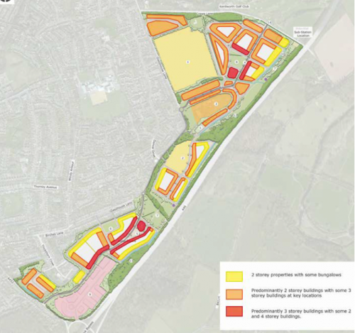
3. Housing Density (Figure 55)
The spatial masterplan assumes an average density across the Development Brief site of 40-45 units per hectare. In order to create a sense of place and to avoid monotonous bland residential areas the housing density should vary across the site. Indicative housing density is higher in the local centre and is typically between 45-50 units per hectare. At this location the housing should consist of a mix of townhouses and terraced cottages in order to create a continuous built edge to streets as they pass through the local centre. Moving away from the local centre the housing would decrease to between 40 and 45 units per hectare. At the periphery of the site the density would decrease further to 35 units per hectare. This low density housing would be set amongst woodland and green infrastructure and allow the housing to be integrated into the wider landscape as well as mitigate the impact on local visual receptors, historic assets and areas of ecological interest.
4. Pedestrian and Cycle Connectivity (Figure 56)

The Indicative Masterplan provides an opportunity to improve connectivity within and around East Kenilworth. The site should create places that encourage walking and cycling as part of people's daily routines. The site should be connected to off-site existing and proposed pedestrian and cycle routes in order to connect new housing to other parts of Kenilworth including the town centre, existing green infrastructure and public open space, key areas of employment such as
the University of Warwick and to the wider countryside. The new residential areas should seek to create a network of multi-user routes suitable for pedestrians and cyclists that are safe and
attractive and encourage people to move around the new community without relying on the motor car. These routes should be linked to public open space, new schools, new local centres and community facilities as well as bus stops. The routes should be set within green infrastructure and also connect the employment site to new residential areas.
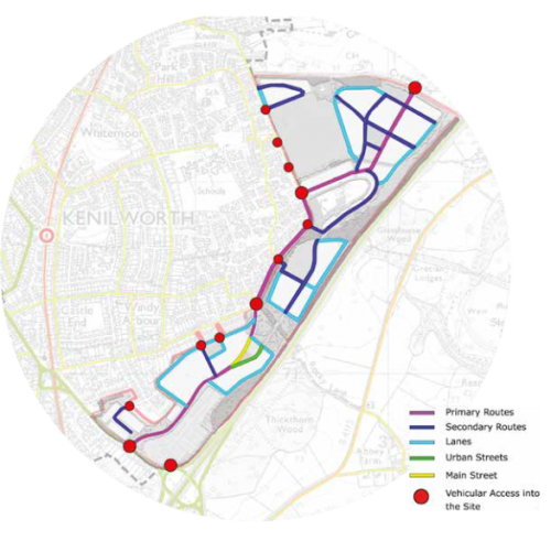
5. Street Hierarchy / Connectivity (Figure57)
The relationship that the streets have with one another and to the built form will have a significant impact on the character of the new residential areas. Streets should be designed as high quality low speed pedestrian and cycle friendly environments with a clear hierarchy based on the following types:
- Main streets
- Urban streets
- Primary routes
- Secondary routes
- Lanes
Street geometry should vary to reflect the function and significance of the route. For example primary routes will be wider than secondary routes and secondary routes wider than lanes. The widths of individual streets should also change according to location and function, i.e. at crossing points within local centres the street should narrow to slow traffic or widen out within the main centre to accommodate parking. Street geometry and hierarchy should also be informed by the characteristics of the existing streets and historic routes within Kenilworth. The design principles for these routes are identified within Chapter 7.
6.
Connected Green Spaces (Figure 58)
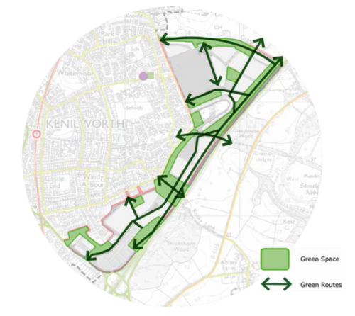
The Scheduled Monument is incorporated into a new linear country park which connects Crewe Lane to the proposed new primary school site. The other main area of green open space is a park located around Rocky Lane and centrally located. Both areas will provide childrens play areas as well as opportunities for recreation and leisure. Allotment sites are also included.
The Green Space Strategy for the site includes:
- Provision of a green corridor through the site linking residential areas and schools with the local centre
- Retention and integration of existing woodland
- Provision of a large central park near to the local centre
- Incorporation of public rights of way
7. Sustainable Drainage (Figure 59)

All future development within the site should identify a strategy for managing surface water drainage in order to reduce surface water run-off and the discharge of surface water into the existing drainage system or watercourses. Sustainable Drainage Systems (SuDS) should be adopted for new residential and employment areas allowing water to be stored and discharged into the drainage system in a controlled way. Typically this will include both surface water attenuation such as swales and ponds as well as below ground attenuation such as oversized drainage pipes.
Development should also consider ways to reduce the amount of surface water entering the drainage system including:
- Capturing and re-using rain water
- Introducing permeable surfaces
- Introducing green/blue infrastructure to capture surface water drainage
- SuDS should be incorporated into green infrastructure and become a natural feature and lie on the low parts of the site to the east.