Land East of Kenilworth Development Brief
(2) CHAPTER 9 - Indicative Masterplan & Scale Parameters Plan
The Indicative Site Masterplan and Scale Parameters Plan have been developed in the context of a consideration of strategic, settlement and neighbourhood level analysis, site level constraints and opportunities, development principles and further placemaking and design principles. Whilst the plan is indicative, development is expected to be in general accordance with the Masterplan and where infrastructure is shown on a particular landholding, it is expected that it will be delivered in that location, unless otherwise agreed by the Local Planning Authority.
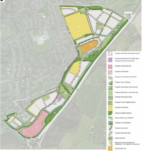
Notes
- Secondary School site
- Preferred Primary School site
- Retained Woodside Hotel
- Main Spine Road
- New Civic Space
- Allotments
- Public Park
- Village Green
- Employment site – set within woodland framework
- Sustainable Urban Drainage
- Low density detached and semi-detached properties set within woodland framework
- Area of Scheduled Monument
- Ancient Woodland Retained
- Access onto Crewe Lane (indicative)
- Location of Community Centre
(7)
Figure 61: Indicative Scale Parameters
Plan
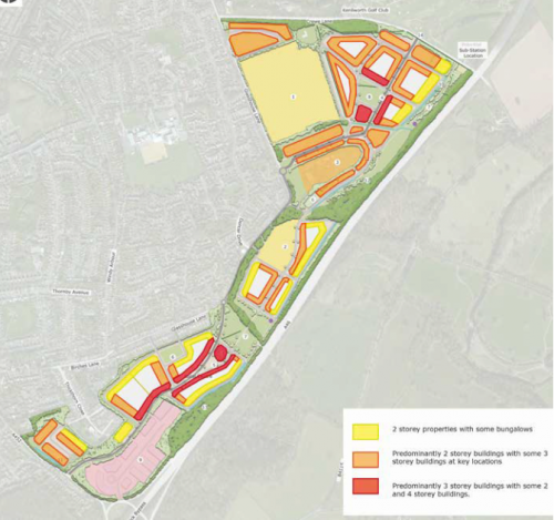
Figure 61 provides an indicative scale parameters plan based on the Indicative Masterplan for different parts of the site. Towards the edge of the site where properties are closely located near to existing residential properties it is recommended that the scale of properties is similar to the scale of neighbouring properties, that is predominantly two storey with some bungalows. For much of the site two storey properties should set the prevailing scale with some 21/2-3 storey properties at key
locations, including in along the route of the spine road. In a few areas of the site in and around the Local Centre, near the employment land and near to the village green to the northern part of the site, buildings of greater scale (3-4 storeys) may be appropriate provided they are well designed and particularly where they provide surveillance over and help frame public open space.
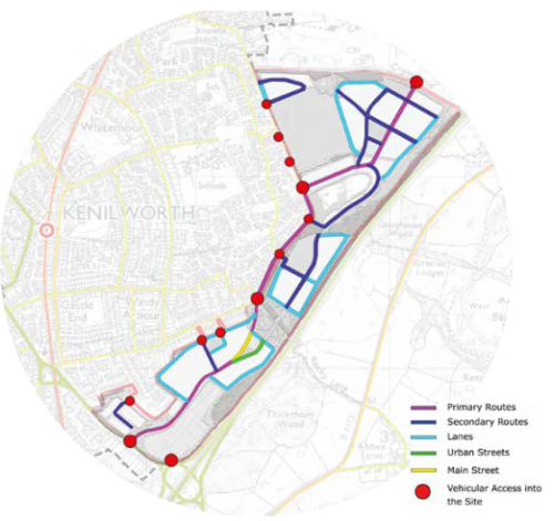
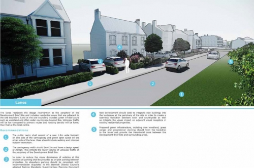
Chapter 8 introduced the hierarchy of streets and street level design principles. The following section describes in more detail with supporting visuals the design principles for each of the street types recommended within the site. These principles are based on the street level Design Principles initially set out in Chapter 7 which were influenced by the Neighbourhood Analysis. This approach means that each of the street types will reflect the important character of Kenilworth's streets and spaces.
Concept Plan no.5 (Figure 57) set out an indicative street typology across the site based on an indicative arrangement of streets within the Indicative Site Masterplan. It is expected that developers follow the street typologies and design guidance associated with each street.
Figure 62: Main Street
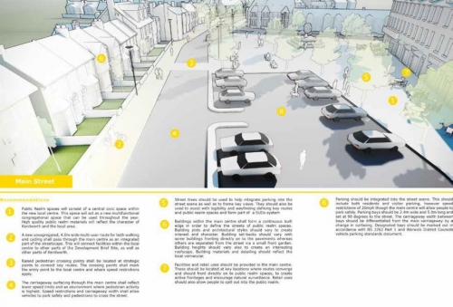
Figure 63: Primary Route
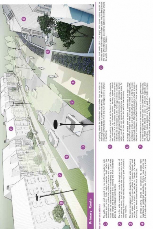
Figure 64: Secondary Route
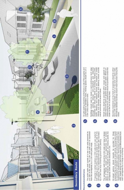
Figure 65: Urban Street
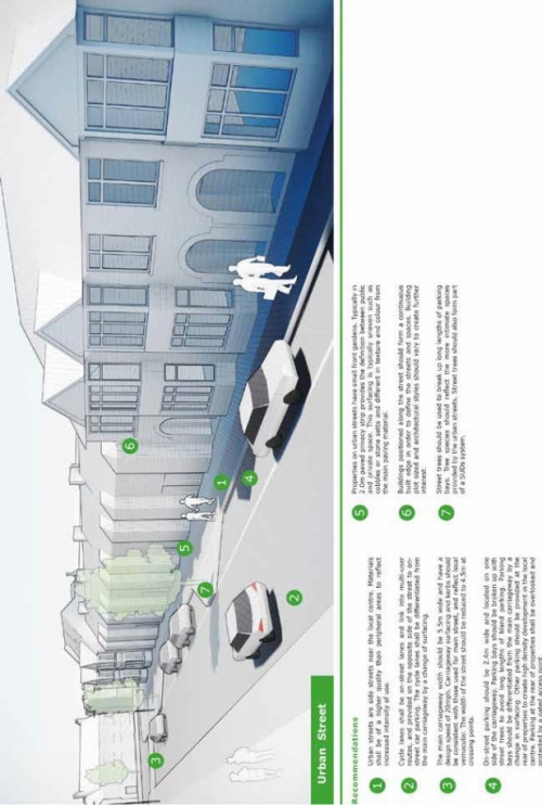
Figure 66: Primary Route adjacent to Employment Site
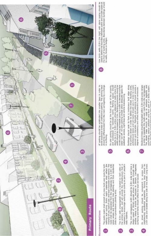
Figure 67: Lanes