Land East of Kenilworth Development Brief
(28) CHAPTER 1 - Introduction
Land East of Kenilworth presents a significant opportunity to deliver a high quality new community within a sustainable urban extension to the eastern side of Kenilworth. The site comprises strategic housing, education and employment allocations in Warwick District Council's Local Plan 2011- 2029 identified to deliver approximately 1,400 new homes, land for education purposes, 8 hectares of employment land, together with other supporting infrastructure.
Background
This Development Brief has been prepared by Warwick District Council following the adoption of the Council's Local Plan 2011-2029 in September 2017. The document will guide future development within strategic allocations to the eastern side of Kenilworth and ensure that development within the sustainable urban extension is considered in a comprehensive manner.
In preparing this consultation document, Warwick District Council has undertaken extensive consultation with key stakeholders including Warwickshire County Council, Kenilworth Town Council, landowners, land promoters and infrastructure providers. A formal six week public consultation with residents and other stakeholders will be undertaken to seek views and inform the content of the document in accordance with the Council's Statement of Community Involvement. Following consultation Warwick District Council will review responses and amend the document where appropriate before seeking approval from the Council's Executive for formal adoption of the Development Brief.
What are Development Briefs?
Development Briefs provide site specific planning guidance usually for large, sensitive or complex sites. They set out guidance on the requirements of development, the quality and quantity of development expected, the spatial distribution of uses on a site and highlight constraints and opportunities presented by a site.
Briefs act as a stepping stone between the higher level content of a Development Plan and the particular requirements of a planning application. They seek to minimise uncertainty and offer specific guidance on particular issues (e.g. urban design; highway matters). Development Briefs can vary significantly in terms of their scope and content depending upon the size and complexity of a site.
The overarching aim of a Development Brief is to secure a higher standard of development than would have been achieved without it.
How will the document be used?
This Development Brief when adopted will have Supplementary Planning Document (SPD) status and will be a material consideration to be afforded significant weight in the determination of planning applications within the area covered by the document. This document does not seek to create additional Local Plan policies but provides detailed development principles that expand upon and help interpret existing policies as they relate to the site.
Guidance contained in this document shall be considered applicable to all development proposals relating to the site whether they relate to outline, reserved matters or full planning applications or applications for the variation/removal of condition applications or discharge of conditions.
Development within the area identified for the sustainable urban extension will need to accord with the Local Plan, guidance within this SPD, other relevant Development Plan Documents including the Kenilworth Neighbourhood Plan, other relevant Supplementary Planning Guidance/Documents and any other material considerations, including the National Planning Policy Framework (NPPF).
Why is housing needed in Kenilworth and why in this location?
The recently adopted Local Plan provides the long-term spatial vision for development in the District until 2029 and sets out the Council's policies and proposals to support development.
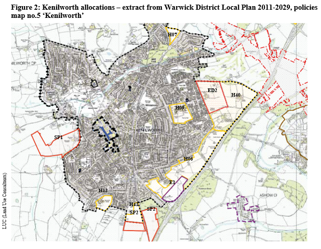
Kenilworth has experienced limited new development in the last 20 years. However, significant growth is now identified for the town in the Local Plan (as shown on the Local Plan Proposals Map no.5 'Kenilworth' – extract in Figure 2) with land for an estimated 1,973 dwellings being allocated across 6 housing sites together with 8 hectares of new employment land, education facilities including a new secondary school and a new primary school and new sites for relocated outdoor sports facilities.
Kenilworth is considered to be an appropriate and sustainable location for significant housing growth given it is an established town with a range of facilities and has good connectivity to the wider road network, has good public transport links and is well related to Coventry in terms of accessibility and functional links. The development offers an opportunity to deliver a diverse range of new housing to meet the needs of the District and providing in part for neighbouring Coventry's unmet housing needs and deliver employment land and other supporting facilities including new schools, a local centre and public open space.
The existing town offers limited opportunity for any significant further housing development within the built up area and the Local Plan Inspector, in paragraph 113 of his 28th July 2017 report, concluded that for Kenilworth, allocations involve land which was in the Green Belt at the time of the examination "given that there are insufficient alternatives... and there are limitations to the scale of housing that can be realistically and appropriately accommodated outside of the Greenbelt, elsewhere in the District".
As part of the Local Plan process various sites were considered for suitability for housing and owing to various factors including the desire to maintain a gap between Kenilworth and Coventry to the north and to Leek Wootton to the south, the importance of protecting heritage assets to the west, most notably the setting of Kenilworth Castle, the proposed route of HS2 and owing to a strong physical barrier in the form of the A46 to the east, it was considered that the most suitable location for significant growth in Kenilworth was to expand to the east on land between Birches Lane/Glasshouse Lane and the A46.
The allocations forming the site covered by this SPD have been subject to a Sustainability Appraisal as part of the Local Plan process. The sites were considered suitable for inclusion in the Local Plan when considering the likely significant effects of the development on the environment.
Figure 1 shows Kenilworth and the Development Brief site in a wider context and Figure 2 highlights the spatial distribution of allocated sites within the town.

Extent and type of development proposed
A sustainable urban extension is proposed to the eastern side of the town on an area of land of approximately 100 hectares which was released from the Green Belt in the Local Plan.
Land for an estimated 1,400 dwellings is allocated in this area on two adjoining strategic housing sites along with 8 hectares of employment land (for B1 and B2 use) to the south- eastern part of the site and 18 hectares of land for education provision to the north-western corner of the site. In addition to these uses further supporting infrastructure is required.
Kenilworth School intend to build a new school to replace the existing secondary school, currently split across two sites within the town and those existing sites are allocated for housing. The new school will meet the needs of the new urban extension and existing residents, providing enhanced educational facilities. Other infrastructure to be provided within the sustainable urban extension includes a new primary school, a Local Centre and community facilities and public open space/play facilities. Furthermore, there will be a need for new and enhanced highway infrastructure to support the development.
The site includes the existing Kenilworth Rugby Club and Kenilworth Wardens Sports Club sites. This land has been allocated for housing as both clubs have aspirations to relocate to new sites with extended facilities and new sites are allocated at Castle Farm (to the west of the town) and land east of Warwick Road (to the south) for outdoor sports provision and the Council is working with both parties to support them in their relocation to their chosen site. The new sites do however remain in the Green Belt.
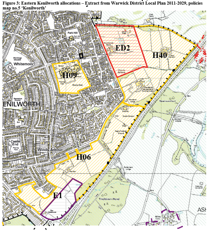
This SPD directly relates to the following allocations in the Local Plan as shown in Figure 3:
- H06 – East of Kenilworth (Thickthorn) – for an estimated 760 dwellings
- H40 – East of Kenilworth (Crewe Lane, Southcrest Farm and Woodside Training Centre) – for an estimated 640 dwellings
- E1 – Land at Thickthorn, Kenilworth – 8 hectares, employment land B1 (business) and B2 (general industrial) uses
- ED2 – Land at Southcrest Farm – education allocation.
Whilst there are other sites with some links to, or in close proximity to the eastern Kenilworth sites such as H09, Kenilworth School Site', allocated for 250 dwellings, these sites do not form part of this Development Brief.
Why is a Brief required for this development?
The quantum of development provides a unique opportunity for the delivery of a sustainable urban extension to the eastern side of Kenilworth and allows the town to expand in a planned and co- ordinated manner with the necessary infrastructure delivered. This document will guide development and assist in ensuring the comprehensive and high quality development of the site.
The development will provide more diverse housing options, including provision of affordable housing. Furthermore, it offers an opportunity to enhance the employment offer in the town and provide significant new employment opportunities and a site for a new and expanded Kenilworth School to enable the school to realise their aspiration to move into new modern facilities.
The allocated sites to the eastern edge of Kenilworth are large in terms of their site area and also in terms of the extent of development that will be delivered. The number of allocated dwellings equates to an increase in population of between 3000-4000 which combined with the other allocated housing sites in Kenilworth will result in around 5000-6000 new residents, amounting to an increase in Kenilworth's population by around one-fifth. It is therefore critical that the development is appropriately integrated into the existing town, is suitably designed and provides the infrastructure required to meet the demands of the new development.
The SPD establishes broad principles and high level design principles to demonstrate how policy requirements should be translated to deliver a viable high quality successful place whilst also providing flexible guidance to have the ability to respond to varying circumstances.
The site is owned by multiple landowners (see Figure 7) and therefore it is considered important to provide overarching guidance to ensure that the multiple applications which are anticipated are prepared in the context of an overall vision for the area. This Brief helps to identify and set out the infrastructure requirements to support the successful delivery of the development as well as identifying any phasing required.
Local Plan Policy DS15 'Comprehensive Development of Strategic Sites' relates to a number of allocated sites including H06 and H40 to the east of Kenilworth. The policy states that proposals for the allocated strategic sites will be approved where they represent a comprehensive development scheme for the whole site. It further states that there will be a requirement to demonstrate this by the submission of either a Development Brief or a Layout and Design Statement as appropriate to be approved by the Local Planning Authority. The Policy highlights that the criteria set out in Policy BE2 shall be addressed and it specifically states that infrastructure including schools, a community meeting place and retail facilities are provided.
Paragraph 2.61 of the Local Plan emphasises the importance of a comprehensive development and why it is necessary stating: "Without a comprehensive development scheme, the delivery of infrastructure and services (such as schools, open space, roads, transport facilities, community facilities and local centres) cannot be guaranteed or properly integrated into the area. In addition, incremental proposals that do not take sufficient account of proposals for the whole site are less likely to deliver a high quality, integrated development that would create a strong sense of place and sustainable neighbourhoods".
Recognising the significance of creating communities within well-designed development and the importance of the delivery of homes and employment land with supporting infrastructure, Warwick District Council has sought to take a leading and proactive role by preparing the Development Brief.
How has the Brief been informed?
This document has been informed by:
- Local Plan Evidence Base including technical reports and representations received during the preparation and progression of the Local Plan, including written statements submitted during examination hearings;
- Individual and group meetings and discussions with the landowners/leaseholders or their representatives and promoters of the sites;
- Technical reports and plans provided by landowners or their representatives and promoters of the site following the adoption of the Local Plan;
- A technical report on highway and transport matters prepared by highways and transportation consultants Atkins;
- Technical design work prepared by urban design consultants, Land Use Consultants;
- Discussions and meetings with various departments of Warwick District Council;
- Discussions and meetings with local Ward Councillors;
- Discussions and meetings with various departments of Warwickshire County Council;
- Discussions, meetings and e-mail exchanges with infrastructure and service providers and other relevant bodies including: Severn Trent Water; Western Power Distribution; Cadent Gas; BT Open Reach; Stagecoach; Highways England; Historic England; and Kenilworth School and Sixth Form;
- Meetings with Kenilworth Town Council and the Neighbourhood Plan Working Group;
- Feedback from the Kenilworth Development Forum at meetings on 13/11/2018 and 21/02/2018 the latter including a workshop specifically seeking the input of the Forum on matters relating to the Brief;
- Feedback provided by Catesby in response to their public consultation in February 2018;
- Pre-application discussions with landowners/promoters.
Document Structure
The remainder of this SPD covers the following:
- Section 2 – The Site: summarising the location and key characteristics of the site and land ownership
- Section 3 – Planning Policy Framework: a summary of key planning policy considerations relevant to the development of the site
- Section 4 – The Site in Context: considering how strategic, settlement and neighbourhood level analysis may inform and influence the development
- Section 5 – Site Analysis, Constraints and Opportunities: a summary of constraints and opportunities relating to the site
- Section 6 – Vision and Objectives: setting out the overarching rationale
- Section 7 – Development Principles: establishment of development principles to guide the form of development and deliver the vision and objectives
- Section 8 – Shaping the Masterplan: further design principles and concept plans
- Section 9 – Indicative Masterplan and Indicative Scale Parameters Plan: a spatial summary in response to considerations in sections 2-6
- Section 10 – Delivery: guidance on expectations for planning submissions, planning obligations and phasing of development and infrastructure