Draft University of Warwick Supplementary Planning Document
Supporting Strategies
One of the main reasons for producing an SPD is to ensure that future developments come forward within the scope of campus wide strategies on:
- Transport and Movement
- Sustainability and Energy
- Ecology and Biodiversity
- Flood Risk and Drainage
- Heritage and Archaeology
Transport and Movement
Key relevant planning policy:
The NPPF notes that Transport issues should be considered from the earliest stage of plan making and development proposals so that
A. the potential impacts of development ono transport networks can be addressed;
B. opportunities from existing or proposed transport infrastructure, and changing transport technology and usage, are realised – for example in relation to the scale, location or density of development that can be accommodated;
C. opportunities to promote walking, cycling and public transport use are identified and pursued;
D. the environmental impacts of traffic and transport infrastructure can be identified, assessed and taken into account – including appropriate opportunities for avoiding and mitigating any adverse effects, and for net environmental gains; and
E. patterns of movement, streets, parking and other transport considerations are integral to the design of schemes, and contribute to making high quality places.
Coventry Local Plan
AC1- Accessible Transport Network
states that development proposals which generate additional trips on the transport network should promote a choice of transport moves, consider the accessibility needs of all residents and visitors, support the delivery of new and improved high quality public transport, and actively support the integration of future intelligent mobility infrastructure.
AC2- Road Network
aims to mitigate and manage any traffic growth generated by proposed development. The primary focus of the policy is on demand management measures including promoting sustainable moves of transport, and secondly on the delivery of appropriate highway capacity interventions.
AC3- Demand Management
sets out the Council's expectations for assessments, reports and parking standards for the validation of proposed development applications.
AC4- Walking and Cycling
states that development proposals should incorporate safe and convenient access to walking and cycling routes.
AC5- Bus and Rapid Transit
sets out the expectation for major development proposals to incorporate safe and convenient access to the existing bus network.
The Air Quality SPD adopted by Coventry City Council in 2019, provides guidance for development proposals and is relevant to Transport. The SPD states that consideration must be given to the air quality impacts associated with proposed development and that mitigation should be incorporated from an early design stage.
Warwick District Local Plan
TR1- Access and Choice
states that the Council will only permit development where it provides safe, suitable and attractive access routes for pedestrians, cyclists, public transport users, emergency vehicles, delivery vehicles, refuse vehicles and other users of motor vehicles.
TR2- Traffic Generation
sets out development Council's expectation that all large-scale development that will result in significant traffic movements will be supported by a Transport Assessment and Travel Plan where relevant.
TR3- Parking
aims to control and manage the expectations of parking provision of proposed developments.
TR4- Safeguarding for Transport Infrastructure
sets out land within the District safeguarded from development. These include the land required for High Speed Rail 2 and areas of search for park and ride.
The Air Quality and Planning SPD adopted by Warwick District Council in 2019 is broadly similar to the Coventry Air Quality SPD and provides guidance on local air quality, and the level of proposed mitigation required to make any scheme acceptable.
Warwick District Council Parking Standards s sets out the expected amount of vehicle and cycle parking to be provided for all types of development, and guidance and design principles for its integration into development proposals.
Transport and Movement Strategy
The University's goal is to reduce indirect carbon emissions generated through all forms of transport and mobility to achieve net zero by 2050. To achieve this, the University will continue to work closely with its communities as it introduces, tests and champions greener, cleaner forms of transport.
The University identified transport and mobility as a key strategic workstream in 2018 and have been taking positive steps since then to tackle the way its community collectively chooses to travel and move goods. A close collaboration with local and regional authorities has seen the campus as a testbed for new and emerging transport technologies.
The overarching aim has been, and will continue to be, to reduce the single occupancy private vehicle usage whilst providing viable non-car alternatives for campus users to consider.
When originally conceived, one of the major benefits of the campus' semi-rural location was its accessibility by car, away from the congestion and transport issues of many cities. But nearly 60 years on, the growth of the University and of car ownership has resulted in peak hour congestion on local roads, which not only impacts on campus users who travel by car but also those traveling by bus; resulting in travel delays and capacity constraints.
Over the last five years the University has taken extensive steps to reduce car dependency and promote sustainable travel options for campus users. These targeted sustainable transport interventions have been further complimented and supported by the notable changes to travel behaviours since Covid-19.
In response to Covid-19 lockdowns the University successfully implemented blended learning (for students) and remote working (for staff). This, alongside the implementation of sustainable transport measures, new mobility trials, an updated parking policy and increased parking charges, has resulted in the following as evidenced by the 2022 and 2023 travel survey and other monitoring data collected by the University:
- Significantly fewer staff and students travelling to campus on a regular basis
- Greater proportion of staff and students travelling to/from campus outside of the peak periods
- More staff and students travelling by non-car modes when visiting the campus
There are significant long-term (post 2033) regional and sub- regional transport investments which will actively influence movement surrounding the campus on both macro and micro scales including:
HS2 and UK Central Developments
The proposed High Speed 2 (HS2) rail route will run to the south-west of the campus, providing connections between Birmingham International and London. As a result of this investment, the West Coast Main Line (WCML) will be upgraded and is expected to provide benefits to the campus through enhanced services at Tile Hill and Canley stations. HS2 is expected to be operational between 2029 and 2033 and the WCML upgrade will be undertaken in parallel. A new HS2 station along with Birmingham International Airport, National Exhibition Centre, Birmingham Business Park, and Jaguar Land Rover are the core components of UK Central. UK Central is being promoted by Solihull MBC and WMCA as a major development opportunity with the potential to deliver 4,000 homes and 77,500 new jobs.
University of Warwick Station [6]
Kenilworth station, located between Coventry and Leamington Spa, was opened in May 2018 and provides improved connectivity to Coventry city centre for local residents. The Coventry Local Plan includes an aspiration to provide a second (University of Warwick) station north of Kenilworth and closer to the University near the King's Hill development site. The implementation of a new University of Warwick station will be dependent on capacity upgrades and the doubling of rail track between Kenilworth and Leamington Spa.
Very Light Rail (VLR)
Very Light Rail (VLR) is a research and development project delivering an affordable light rail system in Coventry. CCC has developed an outline business case for a preferred north-east route linking the city to Walsgrave Hospital. This has enabled CCC to secure funding to support a demonstration track in Dudley to facilitate the necessary legislative sign off on use of the new technology and progress the project through to implementation and operation.
A46 Link Road
Warwickshire County Council developed a proposal for an A46 Link Road as part of a multimodal transport corridor that passed to the south of campus but was unable to demonstrate a viable case. Nonetheless, despite changes in travel behaviour, there are still critical local road congestion issues and insufficient provision for alternative modes of transport (active and public transport infrastructure) in the wider area. Consequently, there may still be a need for this to be addressed in the future both to support the University's continued success and, subject to the Local Plan Review, other development in the surrounding area. In line with our plan to be net zero on scope 3 emissions (p24), the travel hierarchy (Appendix 1, Section 4), and delivery of our eco park (page 15), our preference would be that active and public transport infrastructure would be strongly prioritised. However, this will be a matter for the Local Plan Reviews to consider and determine and the University's plans would respond accordingly.
The transport movement and connectivity strategy of this SPD is in accordance with the following themes:
- Reduce single occupancy vehicle trips to and from campus
- Maintain accessibility through and around campus for all users especially sustainable, non-car modes
- Support more efficient, legible and comfortable movement on campus
- Engage and incentivise behavioural change to support mobility transformation
- Offer choice and variety to all users in order to replace dependency on the private car
- Support the development of innovative and integrated future mobility solutions
- Develop sustainable transport to enhance the environmental sustainability of the campus
These major themes will continue to incorporate two key areas in order to achieve measurable and tangible modal shift:
- "Here and Now" – what the University can, within its control, proactively initiate to help make key evolvement in the mobility and connectivity infrastructure across all transport modes in and around campus
- The "Strategic Regional Infrastructure" investments – working closely with transport authorities to help and support the strategic value of the Transport Corridor to the University and the region, VLR connecting Coventry to the campus area and future mobility corridors such as the cycleway connecting Leamington to Kenilworth.
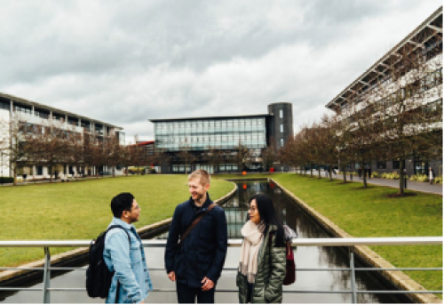
Pedestrian and Cycle Strategy
Traffic congestion, vehicle speeds, parked vehicles, and vehicle-centric spaces currently create hostile and severed streets for people walking, cycling, scooting and wheeling. This undermines the campus experience through unsafe, poor quality, disconnected and non-inclusive spaces.
The approach of this SPD is to aim to reduce non-essential vehicle use on roads within the heart of the campus and the relocation of car parks to the periphery over time will free up more space for pedestrians and cyclists. The campus will offer a much better environment with more cohesive, permeable, legible, direct, safe and accessible pedestrian and cycle routes across the campus that are guided by distinctive and inclusive wayfinding and placemaking principles.
New and enhanced pedestrian and cycle routes will be designed in accordance with local guidance and the Government's National Design Guide, 'Local Transport Note 1/20 – Cycle Infrastructure Design' (LTN 1/20) and 'Active Design Guidance'. Opportunities to downgrade Gibbet Hill Road and reduce vehicle dominance will be a priority should alternative access solutions emerge as part of the Local Plan Review.
Interactive online maps and apps will work alongside printed signage across the campus to help with accessibility. Arrival will be better announced at campus entrances with strong gateway buildings, landscaping and artwork.
Enhanced pedestrian routes and green spaces will encourage more people to walk around campus and engage with their surroundings, leading to casual encounters and interactions, and better occupation and animation of space. Nature will be embedded into the heart of the campus and noise pollution will decrease with less vehicular activity, creating a calmer, healthier environment to improve wellbeing.
The University will continue to regularly monitor utilisation of the more than 3,500 cycle parking space across the campus to ensure sufficient provision is located where it is in highest demand.
To accommodate the expected uplift in active travel up to 2033 and beyond, adequate secure cycle parking and supporting facilities (e.g., showers, lockers, changing rooms, drying rooms) will be provided as part of new developments at least in accordance with adopted local policy.
As part of delivering the SPD, the University is developing a wayfinding strategy that will enhance both on campus movements and connections to key destinations such as transport hubs and nearby urban centres. This will be achieved with intelligent positioning of buildings, creation of "landmark" developments and markers, and immersive technology. Consideration of lighting provision and CCTV form part of this programme to improve both legibility and personal safety through campus.
The University will explore, alongside Warwickshire County Council and Warwick District Council, how an equivalent scheme to the West Midlands Cycle Hire scheme might be delivered in Kenilworth and Leamington to offer the benefits of such a scheme to staff and students living in these areas.
The University will expand and adapt its softer measures to support cycling such as mechanisms to resell and maintain cycles, safety and proficiency training. It will evolve its Cycle to Work scheme to help eligible staff purchase e-bikes and mobility assisted cycles.
Promoting Wider Pedestrian and Cycle Connections
The University in recent years has contributed toward cycleway improvement schemes at both Lynchgate Road and Kirby Corner Road as well the implementation of traffic calming measures at Cannon Hill to improve road safety. The University will continue to work with CCC, WCC, TfWM and their partners such as Sustrans, to deliver new and improved active travel connections to Coventry city centre, Kenilworth, Leamington, Canley and Tile Hill stations.
To support this the University has completed a 'Cycling Improvement Study' and 'Pedestrian Improvement Study' as required by Section 106 Obligations attached to the planning permission for the Social Sciences Quarter. As well as including comprehensive reviews of the walking and cycling networks within the campus, the Cycling Study will focus on gaps and missing links between the campus and student/staff residential locations, public transport interchanges and existing/proposed cycleways. Of particular focus is the consideration of improving connections to Kenilworth Road and Kings Hill to support active travel movement linking to areas of identified growth and key cycle corridors. The Pedestrian Study has adopted a tighter geographical focus on infrastructure gaps on, and in the immediate vicinity of, campus (e.g., missing footways/dropped kerbs/tactile paving, poor lighting).
Public Transport and Shared Mobility
Public transport and shared mobility will be crucial mechanisms in driving modal shift and creating a more sustainable, pleasant campus. Removing non-essential vehicle trips from the heart of the campus will enable priority access along University-owned roads to the benefit of those using sustainable modes such as electric buses, scooting and cycling. Re-allocation of road space, where appropriate to better support bus access will make bus journeys more reliable and attractive to users, whilst continued collaboration with TfWM to support sustainable journeys through incentives, discounts and advice will help drive travel behaviour change further.
The University supports the ongoing replacement of diesel buses with electric buses across the region. Furthermore, it will continue to work with local bus operators and authorities to help make public transport more desirable to those accessing the campus from key connections such as Coventry rail station. This will be based on the following themes:
- dynamically adapting capacity to accommodate changing demand
- aligning bus and rail timetables to provide efficient onward travel
- making public transport travel cost effective for staff and students
- creating University-based bus services that connect staff and students better, also supporting the wider community
- evolving the University service to create a service that is on-demand and complement fixed services
- create a simple, low-cost and seamless environment for all users with one mode of payment for these services
Demand Responsive Transit (DRT) combines the cost effectiveness of bus travel with the convenience of personal mobility services such as private hire and taxis. The University will continue to support TfWM's West Midlands Bus On Demand service and consider how similar services might enable last-mile transport across the campus and connect with local areas in the future.
Such services will:
- Complements fixed network services to reach areas where other options are limited
- Complements fixed network services in terms of seamless connectivity when using multiple modes to travel
- Support the campus's mobility hubs by connecting these to the heart of the campus where private vehicle access will be restricted
- Support special events when demand for transport services increases to help support existing provision
The University will continue to support the delivery of a VLR route between Coventry city centre to the University, which could also connect with existing and proposed mobility hubs and peripheral parking. The University will work closely with CCC to promote a dedicated VLR link to the main campus and will continue to collaborate with TFWM on new innovative transport solutions for the region.
A shift in modal share towards shared mobility will require a wholesale review of the University Interchange to establish whether it can accommodate the anticipated increase in public transport demand. Working with local authorities, and within the design parameters set out in this SPD, the University Interchange will become an expanded gateway to the campus and visually highlight the area as the most convenient method to get to the centre of the University.
The University currently has four car club vehicles (two electric, two hybrid), operated and maintained by Enterprise Car Club, which are available free of charge for business travel only. The University will explore how this scheme could be expanded to reduce business and other private car travel and ownership by staff and students.
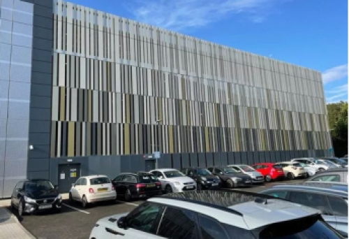
Car Parking Strategy
Through previous masterplans, planning applications and associated Section 106 Agreements, a 'cap' on the number of parking spaces to be provided on campus has been agreed, assessed and mitigated.
Pre-Covid, parking utilisation was typically above 90% during term-time weekdays. However, parking surveys show that utilisation since the lifting of pandemic restrictions and the University's implementation of blending learning/remote working has consistently been around 40%. During the busiest term-time weekday periods there are over 3,000 parking spaces vacant across the campus.
The University has implemented significant changes to the parking tariffs by moving to daily charging to reduce vehicle traffic on campus to enable measures to encourage active travel.
Furthermore, all car parks have become "cashless" and automatic number plate recognition (ANPR) has been introduced to all car parks to create a systems-based permitting/charging structure.
The SPD proposes no change to the parking cap, and over time the University will continue to move car parking towards the periphery of the campus, whilst ensuring essential accessible parking supports existing buildings and new developments.
The University regularly monitors utilisation of its electric vehicle charging infrastructure and, in light of high utilisation, is currently expanding provision across existing car parks. New car parks will ensure adequate provision of electric vehicle charging.
Delivery, Servicing and Waste Strategy
Servicing and deliveries are a large generator of vehicle movements on campus. They also contribute to the large number of vehicles parked across the campus, particularly within the core while specialist University or independent tradespeople undertake their work.
The STEM application proposes to consolidate delivery and servicing activity primarily in a new servicing area accessed from Gibbet Hill Road, with activity relocated from existing piecemeal servicing areas across the STEM site.
The University will continue to apply principles of remodelling, reducing, rerouting and retiming of delivery and servicing activity across the campus. This will serve to reduce road danger, noise and emissions from such activity.
The University's aspiration is to deliver this strategy through implementation of a hub and spoke servicing network with a new consolidation centre on the campus periphery which would allow for a large proportion of campus deliveries to be processed the 'last mile' being completed by smaller electric vehicles or cargo bikes to reduce the number of large motor vehicle movements in the heart of the campus. There will be exceptions to this approach for, for example, time sensitive or servicing of critical or highly sensitive scientific instruments and manufacturing equipment.
Mobility Hubs
The University has a number of mobility hubs around the campus providing access to shared, publicly accessible transport such as e-scooters and e-bikes, alongside cycle parking and other sustainable transport provision. In the future, these hubs will act as designated stops for campus micro transit to provide for longer trips and connections to local destinations.
Mobility hubs will continue to provide interchange and integration between existing and emerging modes across the campus, alongside real-time travel information and, for examples, parcel lockers.
Beyond 2033, as campus car parking is moved towards the periphery of the campus, the new car parks will act as mobility hubs to provide convenient access for onward travel around the campus. A series of smaller mobility hubs will be dispersed around campus and no more than five minutes' walk from any building.
Approach to traffic modelling
The approach to trip generation and traffic modelling, which has been completed using WCC's Kenilworth and Stoneleigh Wide Area (KSWA) model, has been subject to extensive scoping discussions with the transport authorities.
The detailed methodology and modelling results are summarised on the following page. The full modelling assessment report is available to review as supporting information on the consultation website.
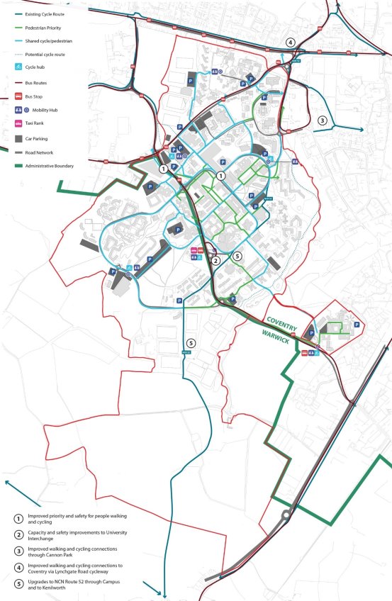
PLAN 15. TRANSPORT ROUTES AND CONNECTIONS
Trip Generation and Traffic Modelling
The proposed development comprising the SPD is summarised in Table 1. These include the:
- Outline permission for Warwick Social Sciences (WSS) for up to 32,000 sqm GIA Use Class F1(a). As agreed with the local authorities, this utilised 19,457 sqm residual floorspace from the Capital Plan Hybrid (CPH) permission (ref: OUT/2018/2115 alongside a commitment by the University in the associated section 106 Agreement, to vacate 12,600 sqm within an Existing Social Sciences Building elsewhere on Main Campus.
- The hybrid application for the Science and Engineering Precinct (STEM) (ref: PL/2023/0002402/OUTM pending determination) for up to a net additional 17,946 sqm GIA Use Class F1(a)
To provide additional robustness and flexibility above the expected maximum floorspace, the SPD trip generation and modelling is based on an additional 31,000 sqm GIA Use Class F1(a) floorspace, 7,196 sqm above the actual expected additional floorspace of 23,804 sqm.
TABLE 1. SPD additional floorspace (sqm) calculation
Proposed Works
Use Class F1(a) GIA sqm
Demolition / Vacant
38,093
New Build / Refurbish
81,354
Net Additional SPD
+43,261
CPH Residual
-19,457
Actual Additional SPD
23,804
Trip generation for the academic floorspace is based on a first principles approach considering maximum building occupancies for the proposed new and refurbished buildings including WSS and the Science and Engineering Precinct.
These buildings will comprise a blend of general teaching, specialist teaching, research labs and workplaces. Bespoke trip rates for undergraduates, postgraduates and staff have been derived and mode shares are based on the University's 2023 travel survey. The methodology has been agreed in principle by CCC, WCC and NH as part of detailed stakeholder engagement.
Alongside academic floorspace, the SPD proposes up to 1,200 student bedspaces – a 16% increase from the existing 7,487 bedspaces. Additional bedspaces enable students to walk or cycle across the campus rather than make external trips from outside the campus on the local transport networks, which provides significant benefits to capacity and congestion.
In order to consider a robust worst-case scenario, as part of the traffic modelling additional bedspaces (which will reduce external trips due to internalisation) will not be incorporated. Several scenarios have been modelled and assessed. The worst-case scenario assesses the SPD's additional trips in a 2037 future year with associated committed development and background traffic growth. The local highway network has areas of congestion and delay prior to inclusion of the SPD, with modest increases in traffic having disproportionate impacts. However, the SPD would not materially alter queueing or delay across the local or strategic road networks. The full 'SPD Trip Generation and Modelling Assessment' report is available to review as supporting information on the consultation website.
The quantum of development provides an upper limit of 31,000 sqm GIA for academic floorspace against which future applications can be considered. Where applications fall within the floorspace limit, there should be no need for additional traffic impact assessment. Furthermore, consideration should be given to the quantum of additional bedspaces that have been constructed to offset any additional floorspace above 31,000 sqm GIA.
The Monitor and Manage approach[7] and Framework Section 106 Agreement will provide the basis for identifying any mitigation measures considered necessary to address the specific impacts of any proposal being considered by the local planning and highway authorities. Where development comes forward outside of these floorspace limits or for uses not assessed through the SPD (for instance, proposals on the Science Park), a separate Transport Assessment should be scoped and submitted with any planning application following the principles set out in the Monitor and Manage approach.
Framework S106, and Monitor and Manage Approach
Over recent years, planning permissions on the University campus have been subject to Section 106 Legal Agreements which have obligated the University to either undertake physical works or make considerable financial contributions relative to transport works. These are summarised below:
- Travel survey of staff and students on a biennial basis for a five-year period with mode share targets for staff and students
- Regular traffic surveys to monitor whether vehicle trips to/from the University during peak periods exceed 16% growth from a 2018 baseline, with a £300,000 remedial payment required to be paid if this is exceeded – surveys in 2022 showed that morning peak period (07:00-10:00) trips reduced by 17% and evening peak period (16:00- 19:00) trips reduced by 2%
- Traffic Regulation Order Contribution: £50,000 utilised by CCC for the traffic calming scheme on Cannon Hill Road
- Cycleway Contribution: £100,000 for Lynchgate Road and £50,000 for Kirby Corner Road, with the former paid and implemented by CCC
- Traffic Calming Contribution: £100,000 was paid to CCC in July 2021 for the traffic calming scheme at Cannon Hill Road which was implemented in 2023
- Highways Contribution: £650,000 was paid to WDC in July 2021 towards the Stoneleigh Road/A46 junction improvement
- Shuttle Bus: Bus service 14, subsidised by the University for two years from September 2020, was implemented in partnership with National Express Buses and now operates as a commercially viable service without subsidy from the University.
The SPD is supported by a Framework S106 with 'Monitor and Manage' elements which set out a framework of agreed mitigations in response to changes in travel behaviour.
This allows individual planning applications to come forward, within the parameters set by the SPD, without the need for these to be subject to standalone traffic modelling and detailed assessment.
The Framework Section 106 is provided at Appendix 1.
A 'Monitor and Manage Transport Sub Board' has been set up comprising representatives from the University, CCC, WCC, WDC, TfWM and NH. This group will monitor, review, co-ordinate and implement the monitor and manage set of principles in relation to all future University development activities, the SPD and associated S106 obligations. The sub board also discusses and manages transport issues and takes opportunities to foster collaboration and sharing of information to improve transport and travel within the local vicinity and encourage positive sustainable transport shifts.
Sustainability and Energy Strategy
Key relevant planning policy:
The NPPF notes that the planning system should support the transition to a low carbon future in tackling climate change and it should help to shape places in ways that contribute to radical reductions in greenhouse gas emissions, minimise vulnerability and improve resilience; encourage the reuse of existing resources, including the conversion of existing buildings; and support renewable and low carbon energy and associated infrastructure.
Coventry Local plan
EM1 Planning for Climate Change Adaption
states that the Council will require all development to be designed to be resilient to, and adapt to the future impact of climate change. Adaptation measures include mitigation against rising temperatures, maximising water efficiency, and minimising risk to flooding.
EM3 Renewable Energy Generation
supports development proposals for renewable and low carbon energy generation technologies, and their incorporation within development proposals.
The Energy SPD aims to support the implementation of Policy EM2 Building Standards which states that development should be designed and constructed to the relevant building standards and meet the carbon reduction targets.
Warwick District Local Plan:
CC1 Planning for Climate Change Adaption
states development proposals will need to be designed to be resilient and adaptive to the future impacts of climate change.
CC2 Planning for Renewable Energy and Low Carbon Generation
states that new low carbon and renewable energy technologies will be supported in principle subject to set criteria including being designed to minimise the impact on adjacent land uses and local residential amenity.
CC3 Building Standards and other Sustainability Requirements
states that all non-residential development over 1000 sq.m are required to achieve a minimum BREEAM standard 'very good' unless it can be demonstrated that it is financially unviable.
Warwick District Council declared a climate emergency in 2019 and has since adopted (May 2024) a Net-zero Carbon DPD. The Council concluded the Main Modifications consultation in July 2023. The objectives of the DPD are to minimise carbon emissions from new buildings and to support national and local carbon reduction targets. The DPD aims to achieve net zero operational regulated carbon emissions by sequentially implementing an energy hierarchy. This hierarchy seeks to firstly reduce energy demand (by improving the building fabric); then incorporating or utilising zero or low carbon energy sources; and as a last resort, where there are residual operational carbon emissions, there will be carbon offsetting requirements.
Alongside the DPD sits the Net Zero Carbon SPD which sets out further advice and guidance to applicants and relevant stakeholders on how to comply with the DPD policies. The SPD has recently been subject to a statutory consultation in October - November 2023.
Overarching University ambition – Net Zero targets
The UN Sustainable Development Goals (UN SDGs) are fundamental to the University's vision to build a better world while addressing the urgent challenges posed by the Climate Emergency. Therefore, the University is committed to reframing the thinking behind decision making, strategic goals and organisation to set a clear pathway to a more sustainable future. The University's current approach "the Way to Sustainable" reflects the collective journey of continuous improvement and the important elements of curiosity, learning, engagement, collaborative planning, and action needed to achieve the most effective outcomes.
The University seeks to ensure that every member of the Warwick community, partners, and networks work together to find ways to be more sustainable through achieving the right balance between providing clear leadership, enabling cooperation, and listening to others. The University seeks to inspire and be inspired, take a practical approach to problem-solving, be prepared to be always listen and learn, be willing to tackle the wicked problems together, and to continuously evolve by doing so.
As part of the University's Climate Emergency Declaration, a commitment has been made to reach net zero carbon from direct emissions, and the energy purchased, by 2030 (Scope 1 and 2 emissions). To achieve this, carbon efficiency needs to be increased drastically in order to change to a reduction pathway. The University commits to achieving net zero for all direct and indirect emissions (Scope 1, 2 and 3) by 2050, and the success of this will mean acting differently now.
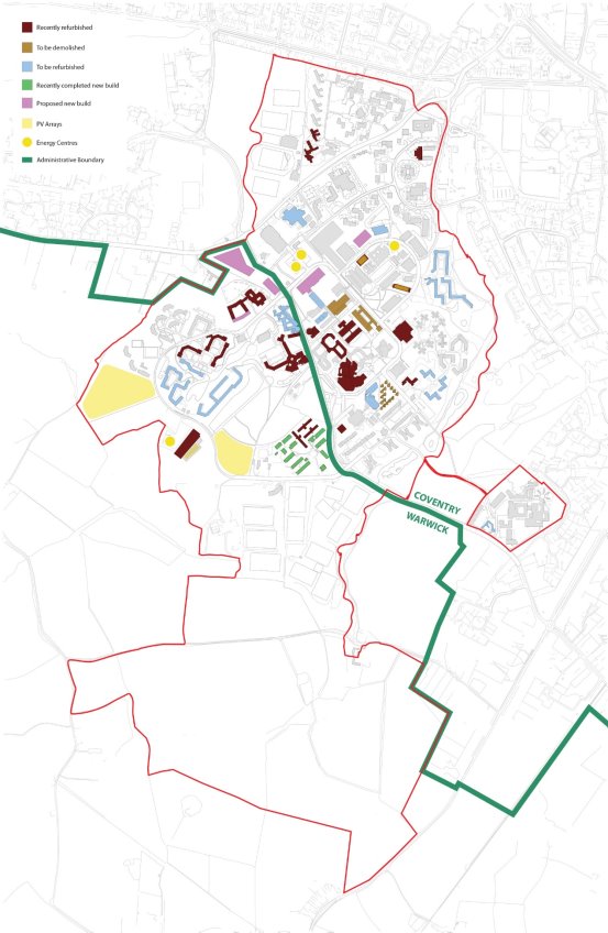
PLAN 16. SUSTAINABILITY PARAMETER PLANS
Reuse/refurbishment
In line with the University's goals on net zero carbon, the University has a hierarchy of decision making and will look to prioritise the re use and refurbishment of existing buildings first, with buildings only being considered for demolition if they are in poor condition or not viable for reuse and demolition or if partial demolition opens up further strategic opportunities.
The University has developed a set of standards which apply to all new construction projects on the Campus, reflecting the University's 'low energy, low maintenance' strategy. This is known as 'The Warwick Standard'. The Warwick Standard provides clear leadership and sets the benchmark for how development is constructed at the University, setting out mandatory design standards which align with the masterplan for the campus. This ensures that all projects are developed and built with uniformly high standards of design which align to the University's strategic goals.
Approach to achieving Net Zero Carbon Emissions
The University is embedding sustainability into all operations to ensure that they can operate resiliently at net zero, or beyond, by 2050 from direct and indirect emissions. In doing so, the University seeks to inspire its community, increasing collaboration with stakeholders and supply chain partners to inform and improve operations.


Transport and Mobility
Goal:
Reduce indirect carbon emissions generated through all forms of transport and mobility to achieve net zero by 2050. If we are going to achieve this, we need to work closely with our communities as we introduce, test, learn and champion greener, cleaner forms of transport.
Actions:
- continue to use our campus as a real-time living lab that enables us to better understand and address the needs of commuters
- accelerate plans to transform the campus transport infrastructure by improving our services, offering more greener, cleaner transport options, whilst continuing to provide better connectivity across our region
- change our policies to emphasise the need to use cleaner, greener forms of travel when travelling on University business
- continue to lead on the conception and development of future transport infrastructure so that we are well placed to enable and accommodate the predicted growth of the University, and our region, whilst also achieving our sustainability target.
As such, number of Sustainable Operations have been identified in respect of Transport and Mobility, Energy, Campus construction, maintenance, and repair, ecology and Biodiversity Net Gain, reducing waste and water.
Energy
Goal:
Our overall goal is to get to net zero carbon from the energy we use by 2030
Actions:
- transition away from fossil fuel gas supplies for on campus operations by 2030
- continue to source green electricity from the National Grid which we have done since 2020
- reduce our reliance on the grid, by selfgenerating renewable energy on campus where viable
- lead the way in creating low carbon energy networks on campus, utilising the existing energy infrastructure combined with viable emerging technologies to create an exemplar future energy network
- improve the utilisation of space across campus, where appropriate and realistically possible, through the adoption of technology and hybrid styles of working developed during the pandemic
- actively seek partnerships with organisations to assist in this transition.


Campus Construction, Maintenance and Repair
Goal:
We have aspired to high levels of building quality and performance since 2015, targeting BREEAM 'Excellent' and EPC A standards, well exceeding regulatory building standards. Our mission is to ensure that our new construction projects across our campuses are net zero carbon developments, and to build and refurbish our stock in an environmentally responsible manner, considering the whole life cycle carbon emissions from our real estate.
Actions:
- continue to ensure that all of our new construction projects are net zero carbon developments; we have already implemented a policy to assess the embodied carbon of our new buildings, enabling informed investment decisions to be made
- evaluate our options to provide new space and facilities on a whole life carbon basis, including opportunities to repurpose existing building where appropriate
- refurbish and improve our pre-2015 real estate, where we need to maintain rather than rebuild, via viable thermal improvements, green energy generation and intelligent operational controls
- improve building controls and space management systems to heat and cool spaces that we use in an efficient way
- implement sector-leading environmental building performance standards for new builds and refurbishments.
Ecology and Biodiversity Net Gain
Goal:
Our goal is to enhance campus biodiversity, targeting the mandatory requirement for 10% net gain compared with pre-development.
Actions:
- allocate a large proportion of our land holding (over 120 acres) on the main campus to re-wilding and parkland for amenity, education and, to assist our transition to renewable energy
- safeguard and enhance existing ecological assets
- encourage people (staff, students, and our local community) to engage with the natural environment through education and research.


Reducing Waste
Goal:
To reduce the total volume of waste produced by Warwick and, if that's not possible, reuse and recycle.
Actions:
- reduce waste being produced in the first place. We will support initiatives that stop waste being created - for example the Warwick Cup scheme, the second-hand bike shop pop-up and the arrivals pop-up shops
- reuse waste that is produced. For example, we will continue to donate a significant amount of 'clean waste' left at the end of the academic year to charity, working with both the compliance and community engagement teams
- recycle as much waste as possible. We are already conducting an infrastructure review (containers, accessibility, collection), and a communications review to encourage more recycling behaviours. We will also improve our processes to segregate new waste streams (cardboard, cables, duvets and bedlinen, and coffee grounds), and we will build on our existing food waste collection activities
- recover waste. We will secure access to a waste to energy plant to dispose of our waste, so that we continue to ensure we send 0% to landfill. We will divert waste from landfill using dedicated material recycling facilities for large items that are not accepted at incinerator resulting in zero waste to landfill.
Water
Goal:
Reduce total campus water consumption, in the interest of reducing carbon associated with water treatment but also to ensure that we preserve this valuable resource.
Actions:
- undertake continual monitoring and targeting to support our water usage plans
- assess a suitable and alternative targeting mechanism based on possible future campus populations
- continue to evaluate the effectiveness of our drainage systems through our ISO14001 Environmental Standard
- undertake comprehensive flood risk assessments to ensure our future buildings are not at risk of flooding and do not exacerbate flood risks elsewhere.
Ecology and Biodiversity Strategy
Key relevant planning policy:
The NPPF describes how planning policies and decisions should contribute to and enhance the natural and local environment including by protecting and enhancing valued landscapes and sites of biodiversity value and minimising impacts on and providing net gains for biodiversity.
Coventry Local Plan
GE1 Green Infrastructure
states that existing GI will be protected and used as a way of adapting to climate change. New development would be expected to make provision of GI and maintain the quality and quantity of existing GI.
GE3 Biodiversity, Geological, Landscape and Archaeological Conservation
aims to protect and enhance SSSIs, LNRs, ancient woodlands and local wildlife and geological sites. This includes the expectation that development proposals will lead to a net BNG, protect or enhance biodiversity assets and secure long term management, avoid negative impacts on existing biodiversity and preserve species that are legally protected.
GE4 Tree Protection
states that development proposals will be positively considered where there is no unacceptable loss of or damage to existing trees or woodlands. The policy also expects removed trees to be replaced with new trees, and for retained trees to be sympathetically incorporated into the overall design. Furthermore, trees that are subject to 'protection' will not be removed without justification.
EM1 Planning for Climate Change Adaption
states that all development will be required to be designed to be resilient to climate change through adaptation measures. For ecology these include optimising the use of multi- functional GI and where appropriate BI.
The Biodiversity Net Gain SPD provides additional guidance on the objectives of Policy GE3, which include facilitating a net BNG, protection and enhancement of biodiversity assets and their long term management, and preserving species which are legally protected, in decline or rare within Coventry.
The Trees and Developer Guidance SPD establishes the Council's expected standards for development proposals with regards to existing trees. This includes retaining and incorporating high quality existing trees within proposed development schemes which will be adhered where possible and appropriate across the SPD area.
Warwick District Local Plan
CC1 Planning for Climate Change Adaption
states that all development is required to be designed to be resilient to, and adapt to the future impacts of climate change. This will include optimising the use of multi-functional GI for urban cooling.
NE1 Green Infrastructure
aims to protect, enhance and restore the district's GI assets on a sub-regional to a local and neighbourhood scale.
NE2 Protecting designated biodiversity and geodiversity assets
confirms that the Council will protect designated areas and species of national and local importance for biodiversity and geodiversity. The policy goes on to states that all proposals likely to impact these sites/ species will be subject to an ecological assessment
NE3 Biodiversity
sets out the Council's expectation that development proposals will protect, enhance and/or restore habitat biodiversity.
Ecology and Biodiversity Strategy
The Ecology and Biodiversity Strategy is based upon the following objectives:
- Safeguard existing ecological sites
- Enhance campus biodiversity
- Sustain and enhance the Great Crested Newt (GCN) population
- Encourage site users to engage with the natural environment
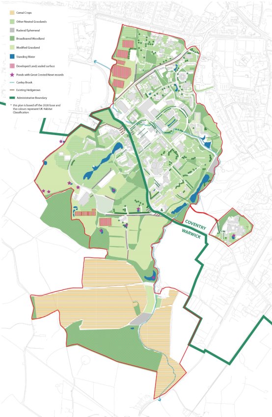
It is based upon an understanding of the Baseline ecological conditions within the SPD boundary. These are identified on Plan 17.
The University is committed to conserving and improving the habitats and species which form the campus's natural assets, and to developing campus biodiversity holistically and not as isolated resources. The SPD boundary contains a wealth of habitats including woodland, mature trees, hedgerows, lakes, ponds, brooks, meadows and open farmland. The University acknowledges the multiple benefits of the environment for health, well-being, food production, climate change mitigation and carbon sequestration.
PLAN 17. BASELINE ECOLOGY PLAN
The University is committed to maximising the ecological value of its estate.
Its commitment to enhancing biodiversity is demonstrated by the numerous habitat creation and management projects that have taken place in recent years including:
- Restoring a large pond through desilting, revetment creation and marginal planting
- Taking part in No Mow May with areas left unmown throughout the summer months
- Wildflower area creation within residences as well as recently laid wildflower turf
- Hedgerow planting to create wildlife corridors; and
- Planting of 900 whips from the Queen's Green Canopy initiative.
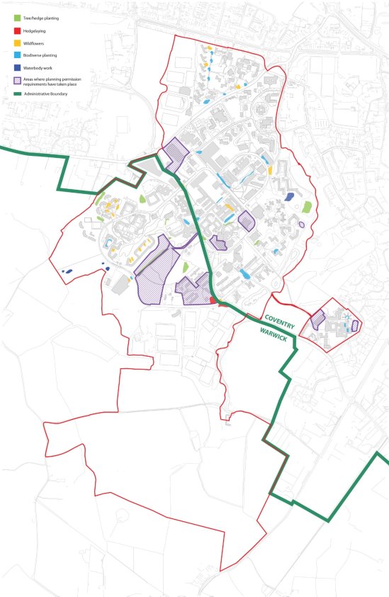
Biodiversity enhancements which have taken place on campus between 2020 and 2023 are shown on Plan 19. This plan also identities locations where enhancements have been undertaken as part of planning permission approvals.
In addition to these projects, we have also started a programme of species monitoring and mapping data on GIS. For example, as part of the Hedgehog Friendly Campus initiative, for which we have achieved the silver award and are working towards gold, we have undertaken hedgehog surveys for the past two years and the surveys have been initiated this year with support from local groups and staff for small mammals, moths, pond health, and birds.
Principle of 'banking'
The approach to habitat creation and enhancement has the potential to create an opportunity for biodiversity gains to be accounted and used to compensate for unavoidable residual impacts of a particular project. Prior to any habitat creation and / or enhancement work outside a built project boundary, a detailed ecological assessment will be undertaken to determine the necessary baseline information and a site- specific ecological management plan produced so that the creation and/ or enhancement can be calculated and used to off-set onsite biodiversity losses. A baseline biodiversity assessment will be undertaken to establish the Biodiversity Net Gain measurement following the proposed interventions.
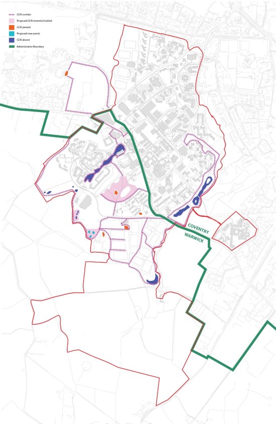
Great Crested Newts
Great Crested Newts are protected under European and UK Law, a species of principal importance in England and a Warwickshire, Coventry and Solihull Local Biodiversity Action Plan species.
A desktop study undertaken by the University show records of 9 ponds within the SPD boundary in which Great Crested Newt have been identified. These are shown on Plan 18.
The ponds which between them support a regionally significant great crested newt population, are all situated along a horizontal belt as shown on Plan 18 surrounded by grassland, hedgerow and woodland habitats which provide cover, food and dispersal routes for the species.
To safeguard the University's GCN population, future development on campus should be focussed away from known GCN ponds and valuable GCN habitat. If impact on GCN habitat is unavoidable, appropriate mitigation measures to be agreed with the relevant Local Authority will be provided.
The campus provides opportunities for the GCN habitat to be enhanced. In line with the enhancement strategy, the University will continue to monitor GCN's across the campus to measure the success of the GCN site conservation and enhancement measures and to inform future development.
Biodiversity Net Gain – principle of campus wide approach
It is noted that Biodiversity Net gain is mandatory under Schedule 7A of the Town and Country Planning Act 1990 (as inserted by Schedule 14 of the Environment Act 2021).
The University's Way to Sustainable Strategy commits to achieving a 10% biodiversity net gain on campus with an overarching aim that the delivery of projects will result in biodiversity being in a better state than before. We will work to ensure a minimum of 10% is achieved for all projects regardless of their size. When identifying and implementing projects to enhance the campus for biodiversity we will be informed by the Local Nature Recovery Strategy and in its absence, the Warwickshire, Coventry and Solihull Local Biodiversity Action Plan (BAP). The University will work with partners to develop the campus to support priority habitats and species where possible, and in turn to support nature's recovery.
PLAN 18. BIODIVERSITY - GREAT CRESTED NEWTS PLAN
The University will prioritise the following habitats from the Local Biodiversity Action Plan
- Built Environment (revision in progress 2021)
- Field Margins (updated November 2021)
- Hedgerows (updated November 2021)
- Lakes and Reservoirs (updated 2021)
- Ponds (revised March 2022)
- Reed beds (updated March 2022)
- Rivers and Streams (updated February 2018)
- Roadside Verges (updated August 2021)
- Traditional Orchards (updated November 2021)
- Woodland (updated November 2021)
The University will prioritise the following species from the Local Biodiversity Action Plan
- Barn owl (updated April 2022)
- Bats (revised March 2022)
- Farmland Birds (updated August 2021)
- Hedgehog (updated 2021)
- Rare Bumblebees (updated December 2021)
- Song Thrush (updated 2021)
- Scarce Arable Plants (updated December 2021)
- Water Vole (updated December 2021)
Approach to delivery of Biodiversity Net Gain
The University is in a unique position in that they have extensive landholdings making up the wider campus as included within the SPD boundary. It is therefore appropriate that a hierarchy approach is created in this SPD to manage the appropriate delivery of Biodiversity Net Gain
The approach is set out below:
- Utilisation of enhancements already banked subject to satisfactory justification that such enhancement have not been double counted
- Provision of mitigation to achieve 10% net gain within the application site
- If (1) and (2) are not possible, or can only be partly achieved, provision of mitigation to achieve 10% net gain within the administrative area in which the application is located
- If (1), (2) and (3) are not possible, provision of mitigation to achieve 10% net gain elsewhere within the SPD boundary
- If no suitable land is available within the SPD boundary, provision of mitigation will be made on other University landholdings.
- Off site mitigation by way of financial contributions to BNG initiatives locally within the administrative areas of Coventry City Council or Warwick District Council (to be agreed by both local authorities).
Future Campus Ecology and Biodiversity Enhancements
Introduction
Future enhancements for ecology and biodiversity will be addressed through the creation of an 'ecopark' to the south of the campus; proposed habitat creation and wildlife enriched interventions within existing areas of the campus; and proposed biodiverse planting alongside new developments. The ecology and biodiversity enhancements should be chosen to support species noted within the Warwickshire, Coventry & Solihull Local Biodiversity Action Plan (LBAP), including farmland birds, hedgehog, great crested newt, bats, small mammals, amphibians and invertebrates. Specific ecological interventions will be guided the LBAP, and the Local Nature Recovery Strategies once they are published.
The key habitats and biodiverse features which will be considered for future enhancements comprise of the following:
Broadleaf Woodland:
Native woodland tree saplings of local provenance will be planted in groups to strengthen existing woodland belts and copses, in order to strengthen ecological corridors and provide refuge for wildlife. Proposed new pockets and linear plantations of woodland tree species will be located in quieter areas and boundaries of the site where they can establish as mature trees, and connect with existing woodland features, strengthening existing habitat present within and adjacent to the campus. Native understory planting should be introduced beneath larger copses of new tree planting. Saplings will be spaced a approximately 2.5m, and species will include both canopy and understory varieties.
Proposed individual trees:
Individual specimen trees, groups of trees and linear street tree planting will enhance the public realm and amenity areas of the campus. Species will include flowering and fruiting varieties to provide a food source for wildlife, and a diversity of species to enhance visual amenity.
Hedgerows:
New hedges will provide a habitat for a variety of species as the dense branches and foliage provide cover and refuge, and berries will provide a food supply for a variety of wildlife. The hedgerows create sheltered movement corridors for wildlife across the site and into the wider landscape. New hedgerow planting will comprise a variety of woody species with herb-rich hedge margins to maximise the variety of wildlife they will support, such as hedgehogs. The new hedgerows will be positioned to provide new migratory routes and strengthen those that already exist, both along the boundary and within the campus.
Wildflower meadow (semi-improved grassland /neutral grassland):
New native wildflower meadows will be created within the site to benefit invertebrates, small mammals and birds. Areas of existing enriched grassland which support low floral diversity will be managed to remediate the enrichment through annual mowing and supplementary seeding to accelerate the creation of a diverse flora akin to a more neutral sward. Floral meadows containing a combination of native and non-native nectar-rich flowers will be used to enhance the central campus amenity spaces and green space margins. Fields margins will be managed to enhance their biodiversity value, sown with native species to provide seed for wild birds or with wildflowers or agricultural legumes to provide pollen and nectar resources for invertebrates. The current species poor roadside verges will be managed to provide a more diverse flora. The management will involve annual cutting with supplementary wildflower seeding and plug planting. 'No-mow' grass verges will increase species diversity. Care will be taken to avoid invasive species and those which are susceptible to diseases such as Phytophthora, Acute Oak decline, and bleeding canker. Plants will be UK grown where possible, and will be sourced from nurseries that are part of the 'Plant Healthy' scheme.
Water course / water bodies:
In order to improve the diversity of water bodies / wildlife ponds, the marginal habitats will be enhanced with a mix of plant species which will provide cover and sources of nectar. The marginal habitat and species diversity will be enhanced using seeding supplemented with plug planting or through the installation of pre-planted coir mats to provide instant vegetation to the margins. Further naturalisation of the Canley brook would create more permeability for species which depend on linear water features. Planting to reinforce the existing bankside vegetation and create more structure and diversity would also provide benefits for other small mammals, birds and invertebrates within the site.
Biodiverse swales and rain gardens:
New developments are to prioritise the use of surface water attenuation / surface water attenuation (SuDS), to create vegetated swales and rain gardens. Planted swales will promote infiltration and reduce run off rates and volumes. A variety of plant species, both native and non-native, will be introduced for visual interest and to provide a valuable wildlife habitat.
Biodiverse Planting:
New biodiverse planting within residential areas central campus will support wildlife, boost biodiversity and create seasonal longevity. Plant selection will prioritise a rich source of nectar for beneficial insects, birds and small mammals, including species with spring blossom and berries. British native species will be supported by nectar-rich ornamental species, to extend the flowering season and create a planting matrix which will be easily manageable, with seed heads retained during winter. Spring flowering bulbs will enhance areas of amenity grass.
Within residential areas of the site will include the introduction of bio-diverse edibles / herb beds.
Building biodiversity into Architecture:
The provision of green roofs and walls, biodiverse landscapes and nesting / roosting boxes will provide refuge and foraging habitats for a range of species, whilst creating stepping stones for wildlife to migrate across the site. Architectural green infrastructure including green and blue roofs, green walls, bird and bat boxes in building infrastructure will furthermore enhance the built environment. These features will be considered retrofitted to existing buildings where appropriate, and for new builds.
Artificial Refugia:
Strategic positioning of bird and bat boxes and hibernaculars within existing trees, semi-improved grassland, woodland, field and water margins, will increase the diversity of fauna within the site. Types of hibernacular could include, but not limited to, insect 'hotels', hedgehog homes, artificial bat roosts and bird boxes.
PLAN 19. ECOLOGY AND BIODIVERSITY ENHANCEMENTS
Flood Risk and Drainage Strategy
Key relevant planning policy:
The NPPF states that inappropriate development in areas at risk of flooding should be avoided by directing development away from areas at highest risk (whether existing or future). Major developments should incorporate sustainable drainage systems unless there is clear evidence that this would be inappropriate.
Coventry Local Plan
EM1 Planning for climate change adaption
states that all development will be required to be designed to be resilient to climate change through adaptation measures. For flood risk and drainage, this means optimising the use of multi-functional GI for local flood risk management, minimising vulnerability to flood risk by location of development in low flood risk areas and including mitigation measures.
EM4 Flood Risk Management
states that all development proposals will be assessed in respect of the level of flood risk form all sources. Development will need to provide a minimum standard to flood defence and resilience and not increase flood risk on site or elsewhere to reduce overall flood risk.
EM5 Sustainable Drainage Systems
aims to ensure all development apply SuDS to ensure surface water runoff is managed as close to its source as possible.
Warwick District Local Plan
CC1 Planning for Climate Change Adaption
states that all development is required to be designed to be resilient to, and adapt to the future impacts of climate change. This will include optimising the use of multi-functional GI for local flood risk management and minimising the vulnerability to flood risk by locating development in areas of low flood risk.
FW1 Reducing Flood Risk
aims to ensure development is located in areas of low flood risk, and ensuring all new development is resilient to surface water, fluvial and pluvial flooding.
FW2 Sustainable Drainage
states that all major developments must incorporate SuDS that provide biodiversity, water quality and amenity benefits. The policy also states that all new development sites will discharge at QBAR greenfield run-off rate, including an allowance for climate change.
Baseline conditions / drainage model
The majority of the SPD boundary is identified as falling within Flood Zone 1 of the Environment Agency's Flood Risk Map for Planning. This is recognised as the area with the lowest risk of flooding. Part of the southern area, at Tocil Wood, lies within Flood Zone 3 – the Canley Brook floodplain. Notably the existing flood risk map for planning only includes large catchments as such water courses are not modelled and separate modelling is being undertaken by the University.
The campus benefits from its rural location with a relatively large amount of green space and differing ecological habitats. A large number of the ecological features on site are also provided as part of the water management strategy.
Sustainable Drainage Systems (SuDS) are the main flood mitigation strategy in use within the campus. There are many existing SuDS features on site including ponds, swales and filter trenches. These features can be re-used and improved to accommodate additional surface water runoff, with additional SuDs features added to the campus.
Water and Surface Water Network
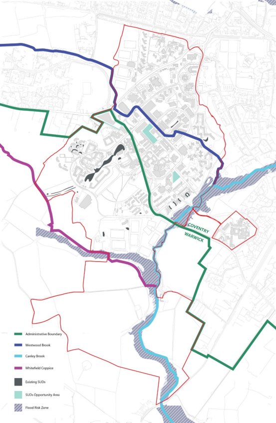
The surface water network can be split into two main sub-catchments:
- Westwood Brook Sub-Catchment
- Whitefield Coppice Sub-Catchment
Both sub-catchments ultimately drain to the south of the University and into the Canley Brook. The Canley Brook flows between the Central Campus and Gibbet Hill Campus in a south westerly direction before discharging further downstream into the Finham Brook. Canley Brook is a designated main river by the Environment Agency. There is also a smaller sub- catchment located on Gibbet Hill.
Westwood Brook Sub-Catchment
The Westwood Brook flows from the north to the southeast through the sub-catchment either through a series of culverts or via open channel flow.
The majority of the University's built environment is in this sub-catchment, therefore there are a number of outfalls that discharge directly into the Westwood Brook. Further north at the Westwood Campus, surface water is discharged via the Severn Trent public network into a tributary of Westwood Brook. More recent buildings have individual attenuation structures to control the volume and rates of discharge.
The existing surface water network draining into the Lakeside and Heronbank ponds flow across to the Westwood Brook sub-catchment and discharges into the Westwood Brook via a surface water pumping station located in front of the Engineering Block on University Road.
There are ponds located adjacent to Tocil Wood. It is noted that these are aesthetic and not considered to be used for surface water attenuation as they are located within the Canley Brook floodplain.
Whitefield Coppice Sub-Catchment
This sub-catchment is mostly drained by a small watercourse to the east of Whitefield Coppice, which as previously noted drains into the Canley Brook.
The Lakeside and Heronbank ponds are only partly used for the attenuation of surface water runoff from some of the Lakeside residences. The remainder of the Lakeside residences and Heronbank are attenuated in four below ground detention tanks, with two of these being pumped into the ponds. As previously noted, all flows from the ponds eventually drain to the surface water pumping station in the Westwood Brook sub-catchment before discharging into the Westwood Brook.
There is a small natural pond behind the Heronbank buildings on the Hill Top site. It is not used for attenuating surface water runoff. The location of the pond suggests there is a potential flood risk for the Heronbank buildings during extreme storm events resulting from surface water shedding from the elevated Hill Top site.
Flood Risk
A study of the EA's online flood map, 'Risk of Flooding from Surface Water', suggests that the majority of the SPD boundary lies in a very low risk area with some medium and high-risk areas across the campus.
The majority of the University's built environment is located in the Westwood Brook sub-catchment and therefore it is important to understand the potential flood risk from the Westwood Brook. A detailed hydraulic analysis was undertaken in 2007 and updated in 2013 so that the 1 in 100-year floodplain for the Westwood Brook could be determined.
The results of the analysis confirmed that no buildings were impacted by Westwood Brook up to the 1 in 100 year plus 20% climate change event.
The Westwood Brook Hydraulic model is in the process of being updated to reflect modern modelling standards and current climatic conditions to inform the flood extents within the campus in line with Environment Agency and Lead Local Flood Authority requirements.
There are no concerns about floodplain encroachment for the Whitefield Coppice sub-catchment, as the sub-catchment is topographically elevated above any such constraint.
The discharge of surface water from a new development will take into consideration the drainage hierarchy with infiltration being the preferred option and discharge to a combined sewer being the least favourable.
SUDS should be incorporated into the design of new development to manage and control runoff unless there are practical reasons for not doing so. Consideration should be given to the use of source control features as part of a treatment train to improve water quality prior to disposal off-site. A Flood route exceedance plan should also be provided to show how flooding could be managed in the event of a blockage or a storm that exceeds the design event of the infrastructure.
Sequential/Exception test
New developments should be located in areas at low risk of surface water and fluvial flooding. In areas where this cannot be achieved, suitable evidence will need to be provided to demonstrate that there are no other alternative sites within the University of Warwick campus that are suitable for the development. Any residential development to be located in a high-risk flood area will also need to pass an Exceptions Test. If required, both a Sequential Test and Exceptions Test will need to be submitted at the planning stage to support the FRA.
Sustainable Drainage Systems (SuDs)
Future development within the SPD campus will prioritise the use of SuDs. The overarching aim is to reduce run off rates and where possible deal with surface water as close to its source and incorporate biodiversity into schemes. The landscape context of the SuDs will be taken into account as well as the engineering requirements.
When considering the use of SuDs, development within the SPD boundary will use the following list of potential options in order of priority, depending on the appropriateness of each feature for the specific development.
Suds Method
Description
Potential Locations
Green & Blue Roof
Vegetated or hardstanding roof designed to store water, which can be used for irrigation, cooling water or non-potable use within the building.
Proposed flat roofs could be designed with this feature if structural capacity, extra loadings and waterproofing are taken into consideration within the design.
Rainwater Harvesting
Rainwater from roofs and hard surfaces can be stored and reused.
Rainwater storage tanks can be located either underground, indoors on roofs or adjacent to buildings, depending on site size and access requirements.
Permeable Paving
Surfaces can be either porous or permeable. Rainwater infiltrates through the surface and into underlying layers where it is temporarily stored before either infiltrating into the ground or discharge through the drainage system.
Permeable paving can be located within proposed hard landscaping areas, especially in public realm areas.
Swales
Shallow, broad and vegetated channels designed to store and/or convey runoff and remove pollutants. Check dams and berms can also be installed along the flow path to promote settling and infiltration.
Swales may be utilised within the narrow, landscaped areas of the proposed plan to slow down and convey rainwater runoff.
Filter Drains/strips
Shallow excavations filled with gravel to create temporary storage of runoff used to filter and convey rainwater.
Due to ifs linear feature, filter drains are well suited to manage runoff from roads, car parks and other impermeable areas in verges or within landscaped areas in public realm areas.
Infiltration Basin
Vegetated depressions designed to store runoff on the surface and infiltrate it gradually into the ground.
Can be incorporated into large open areas of soft landscaping.
Rain Garden
Relatively small depressions in the ground that act as infiltration points for roof water and other 'clean' surface water runoff (low contamination levels).
Can be implemented in private curtilage for managing runoff from single properties, in small shared public spaces, on car park islands, roundabouts, footpaths, traffic calming and pedestrian zones.
Detention Basin
Surface storage basins are normally dry and provide flow control through attenuation of stormwater runoff.
Can be incorporated into large open areas of soft landscaping.
Retention Pond
Retention ponds provide stormwater attenuation and treatment.
Can be incorporated into large open areas of soft landscaping.
Geocellular Storage Systems
Geocellular systems can be used to control and manage surface water runoff.
The modular systems mean that they can be tailored to suit specification requirements of any site.
Management and Maintenance
The University monitors and manages its current drainage system, working to the aim of ensuring it is robust, resilient and sustainable. In addition to several existing SuDs intervention across the campus, through the development of the Eco Park project there are emerging ideas exploring the opportunity to utilise land parcels to both support wetland habitat creation and natural management of water. Also, the University has an experienced grounds and gardens maintenance team for whom the monitoring, management and maintenance of our existing SuDs features is a key task that they undertake, as these features are an active part of the University landscape. The team are supplemented by specialist external contract support, where required.
PLAN 20. DRAINAGE PLAN
Heritage and Archaeology Strategy
Key National and Local legislation and Policy
The Planning (Listed Buildings and Conservation Areas) Act 1990 sets out the following duties for the decision maker in determining applications for listed building consent and planning permission affecting statutory listed buildings and/or their setting:
"S.66 (1) In considering whether to grant planning permission for development which affects a listed building or its setting, the local planning authority or, as the case may be, the Secretary of State shall have special regard to the desirability of preserving the building or its setting or any features of special architectural or historic interest which it possesses."
The NPPF requires that planning should "conserve heritage assets in a manner appropriate to their significance, so that they can be enjoyed for their contribution to the quality of life of this and future generations." with Chapter 16 outlining guidance regarding conserving and enhancing the historic environment.
Local Plan Policy
Warwick District Local Plan
Policy HE1: Designated Heritage Assets and their setting
Development will not be permitted if it would lead to substantial harm to or total loss of the significance of a designated heritage asset, unless it is demonstrated that the substantial harm or loss is necessary to achieve substantial public benefits that outweigh that harm or loss, or it is demonstrated that all of the following apply:
A. The nature of the heritage asset prevents all reasonable uses of the site; and
B. No viable use of the heritage asset itself can be found that will enable its conservation; and
C. Conservation by grant funding or charitable or public ownership is not possible; and
D. The harm or loss is outweighed by the benefit of bringing the site back into use.
Where development would lead to less than substantial harm to the significance of a designated heritage asset, this harm will be weighed against the public benefits of the proposal, including securing its optimum viable use.
- Experience of the asset;
- An asset's associative relationships with other heritage assets. It is identified that views which contribute more to understanding the significance of a heritage asset include the following:
- Those where the composition within the view was a fundamental aspect of the design or function of the heritage asset
- Those where town- or village-scape reveals views with unplanned or unintended beauty
- Those with historic or cultural associations.
Coventry Local Plan
Policy HE2: Conservation and Heritage Assets
1. In order to help sustain the historic character, sense of place, environmental quality and local distinctiveness of Coventry, development proposals will be supported where they conserve and, where appropriate, enhance those aspects of the historic environment which are recognised as being of special historic, archaeological, architectural, artistic, landscape or townscape significance. These Heritage Assets include:
A. Listed Buildings and Locally Listed buildings;
B. Conservation Areas;
C. Scheduled Ancient Monuments and Archaeological sites;
D. Registered Parks and Gardens; and
E. Other places, spaces, structures and features which may not be formally designated but are recognised as significant elements of Coventry's heritage and are positively identified on the Coventry Historic Environment Record.
2. Proposals likely to affect the significance of a heritage asset or its setting should demonstrate an understanding of such significance using currently available evidence.
3. Development proposals involving heritage assets in general and listed buildings in particular, should acknowledge the significance of the existing building and the area by means of their siting, massing, form, scale, materials and detail.
4. The sympathetic and creative re-use of heritage assets will be encouraged, especially for heritage that is considered to be at risk, so long as it is not damaging to the significance of the heritage asset. The embodied energy present in historic buildings contributes to sustainability.
5. The Council will use its statutory powers to secure the preservation of buildings and other heritage assets that are deemed to be at risk by the national and local heritage at risk registers.
6. Demolition or destruction of heritage assets will be resisted; proposals to demolish a heritage asset will therefore need substantial justification. The greater the damage to the significance of the asset, the greater the justification required and the public benefit needed to outweigh such damage.
7. All proposals should aim to sustain and reinforce the special character and conserve the following distinctive historic elements of Coventry:
A. The surviving buildings, defences and street plan of the medieval city centre and its suburbs;
B. The surviving pre-industrial settlements and landscape features which have been subsumed by the expansion of the city such as Walsgrave, Canley, Binley, Brownshill Green, Coundon Green, Little Heath (Spring Road), Stivichall Croft and Lower Eastern Green (at Dial House Lane);
C. The wider Arden rural environment on the fringe of the city comprising field-systems, ancient woodlands and commons which developed over centuries; interspersed with a mix of settlements, farmsteads and smallholdings;
D. Buildings associated with the city's industrial heritage; ribbon weaving, watch making, cycle making, motor car manufacturing, brick making, coal mining, synthetic textiles, munitions, aeronautical engineering, canals and railways;
E. The Victorian and Edwardian suburbs such as Earlsdon and Stoke;
F. Designed landscapes, including historic parks and gardens (both registered and locally listed), historic cemeteries, churchyards and public parks;
G. The significant elements of Coventry's ground-breaking post-war reconstruction including its plan, built form, public art works and public spaces; and
H. Archaeological remains of all periods from the earliest Prehistoric human habitation to the modern industrial period.
8. Where material change to a heritage asset has been agreed, recording and interpretation should be undertaken to document and understand the asset's archaeological, architectural or historic significance. The scope of the recording should be proportionate to the asset's significance and the impact of the development on the asset. The information and understanding gained should be made publicly available, as a minimum through the Coventry Historic Environment Record.
Baseline heritage conditions
There are a number of built heritage assets within or immediately adjacent to the SPD boundary.
These are identified on the Heritage Asset Plan and are summarised below:
Houses For Visiting Mathematicians
3B Series 1 Sculpture
Within the SPD boundary
- Houses For Visiting Mathematicians. Grade II*. North East of the Warwick Medical School, Gibbet Hill. (1)
- 3B Series 1 Sculpture. Grade II. Located within the courtyard of the Rootes Residential Building (4)
- Cryfield Farmhouse, Gibbet Hill Road. Grade II. (3)
Adjacent to the SPD boundary
- Cryfield Grange Farmhouse, Cryfield Grange Road. Grade II (5)
- Church of St John the Baptist, Westwood Heath Road. Grade II (2)
- South Winds, Cryfield Grange Road. Grade II (6)
- Kenilworth Road Conservation Area
The information about heritage assets and the desk based assessments have been used in the considerations which have led to the development proposals and design guidelines set out in this SPD. In accordance with heritage best practice, additional heritage surveys relative to specific planning applications may be required to inform future decision making.
Where development is proposed which may impact on the identified Heritage Assets, proposals should seek to preserve and enhance the asset and its setting, in line with adopted national and local policy and guidance.
PLAN 21. HERITAGE ASSETS PLAN
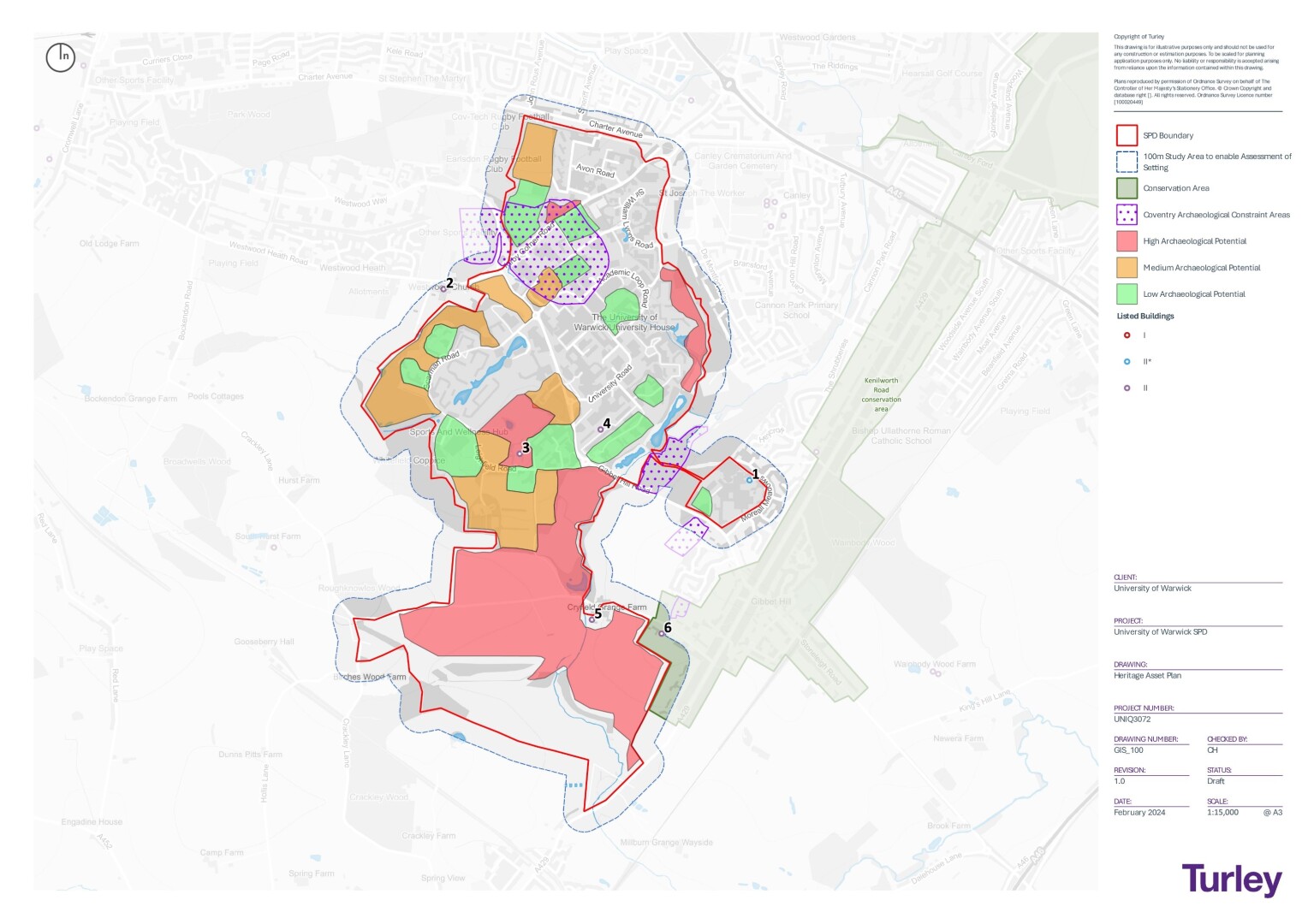
Archaeology
The Campus has been subject to a considerable amount of archaeological fieldwork connected with planning applications and construction activity over recent years. To inform this SPD, a comprehensive Archaeological Desk Based Assessment has been undertaken. Information from this Assessment is included on the Heritage Asset Plan (Plan 21)
The DBA has identified a number of archaeological 'events' and non designated assets across the site. These attest to a wide range of evidence of human activity and settlement of the land within the site from the prehistoric period onwards. There is also a legacy of previous archaeological investigations which have been prompted by previous development and work undertaken by Dr Stephen Hill, former University Archaeologist.
The Archaeological DBA has established that the archaeological potential of the campus varies by period and location. The Heritage Asset Plan identifies areas within the SPD boundary with high, medium and low archaeological potential. This information has been used to inform the development principles as set out in this SPD and will be used to guide future development within the SPD boundary.
National planning policies and planning guidance contained within the National Planning Policy Framework (DLUHC 2023) and its accompanying Planning Practice Guide (MCHLG 2016, updated November 2023, historic environment section published 2014, updated July 2019), as well as relevant local planning policies , require a mitigation response that is designed to take cognisance of the possible impacts upon heritage assets by a Proposed Development and avoid, minimise or offset any such impacts as appropriate.
Future development will be required to assess the potential for construction works to directly or indirectly impact on below ground remains. The extent of assessment will depend upon the level of potential of the site under consideration, with engagement with the Local Planning Authority Archaeological advisers informing the assessment strategy. The level of mitigation proposed will be informed by the results of the investigations and in consultation with the relevant advisers.
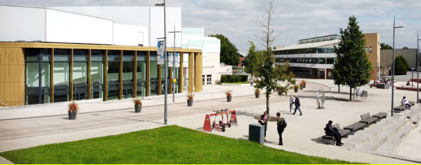
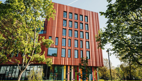
[6] WCC's Warwickshire Rail Strategy (2019): https://ask.warwickshire.gov.uk/communities/draft-warwickshire-rail-strategy-2019-2034/supporting_documents/WRIS%20DRAFT%20for%20consultation%20201934%20FINAL.pdf
WMRE Rail Investment Strategy (2022): https://wmre.org.uk/our-strategies/west-midlands-rail-investment-strategy/
[7] A Monitor and Manage approach builds on a change in attitude to the issue of travel and movement. It seeks to stop using past traffic trends to determine the future need for infrastructure, as this maintains the status quo by perpetuating dependence on cars. This enables more positive transport planning and helps implement a hierarchy of users by considering walking, cycling and public transport upfront and supporting net zero ambitions. A fundamental part of this approach is the need to monitor travel behaviour over time and manage the implementation of targeted transport interventions to support sustainable travel.