Draft University of Warwick Supplementary Planning Document
Planning Context
From 1965 to now
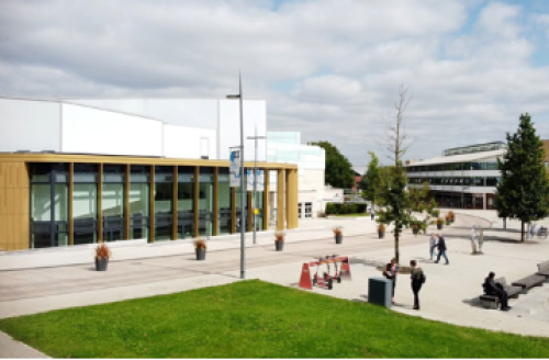
The University of Warwick was founded in 1965 and has had approved masterplans throughout its history, most recently the 2009 Masterplan Outline Planning Permission and the 2018 Capital Plan Hybrid Permission, which have guided recent developments on campus such as the Lord Bhattacharyya Building, Oculus, the Slate, the Sports Hub, Cryfield Village, the IBRB at Gibbet Hill, the Warwick Arts Centre extension, the new Faculty of Arts Building, along with two new multi-storey car parks at Lynchgate and Kirby Corner.
These permissions were accompanied by a Section 106 Agreement which ensured appropriate mitigation of traffic impacts, support for public transport and management of car parking on campus.
The next phase of development is now underway, with plans for a new Social Sciences Quarter including new buildings for the Business School and Economics, and a multi-phase refresh of science, technology, engineering and mathematics (STEM) facilities around a new Science and Engineering Precinct in the heart of campus. There is also greater focus on energy efficiency as the University moves towards Net Zero and a less car-dependent movement strategy is being implemented. Recent events have accelerated changes to the way the staff and student body use the campus, with more flexible working and blended learning. These changes are reflected in the University's current thinking about how it develops the campus.
PHOTO 1. Lord Bhattacharyya Building
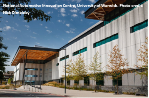
PHOTO 2. Oculus
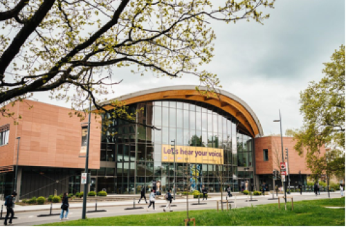
PHOTO 3. The Slate
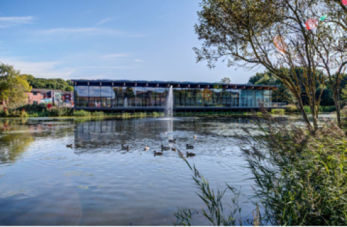
PHOTO 4. The Sports Hub
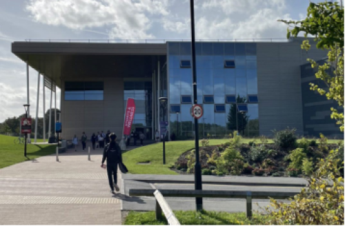
PHOTO 5. Cryfield Village
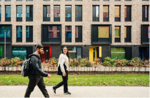
PHOTO 6. The IBRB at Gibbet Hill
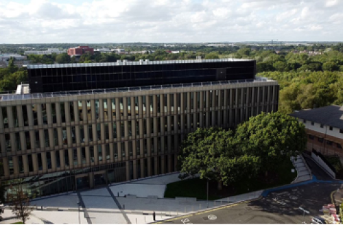
PHOTO 7. The new Faculty of Arts Building
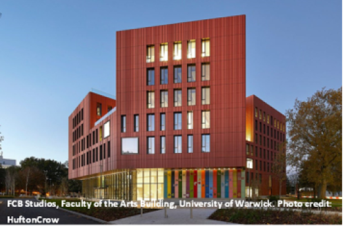
PHOTO 8. New multi-storey car park at Lynchgate
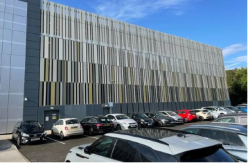
PHOTO 9. Warwick Arts Centre extension
Planning Policy
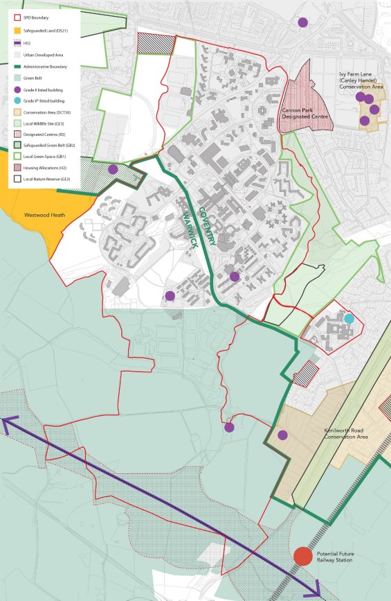
The campus sits across two local authority areas – Coventry and Warwick District, with the main academic part of campus in Coventry and the more residential and recreational areas within Warwickshire.
All of the built part of campus was removed from the Green Belt in 2017 but the sports fields and countryside to the south remains in Green Belt.
The adopted local plans for the campus are:
- The Coventry Local Plan 2011-31, adopted in 20171[1]
- The Warwick District Local Plan 2011-2029, adopted in 20172[2]
Coventry Local Plan
The planning policy context for the northeastern extent of the campus is established in the Coventry Local Plan, adopted in December 2017.
The key policy within the Coventry Local Plan of relevance to this SPD is JE1 Overall Economy and Employment Strategy. This policy confirms that the council will work in partnership with the City's universities to promote and support innovation. The policy objective being to maximise the economic development and community benefits associated with the continued growth of the universities.
This masterplan has therefore, in part, been produced in the context of Policy JE1 of the Coventry Local Plan.
Other relevant policies within the Coventry Local Plan include:
- DS3 Sustainable Development Policy which confirms the Council will take a positive approach to development that reflects the presumption of sustainable development contained within the NPPF.
- CO1 New or Improved social community and leisure premises states in part 3 that proposals that are in accordance with the approved masterplan will normally be approved subject to high quality design proposals.
Warwick District Local Plan
The planning policy context for the southwestern extent of the campus is established in the Warwick District Local Plan, adopted September 2017.
The main policy within the Warwick District Local Plan of relevance to this SPD is Policy MS1 University of Warwick. The policy states that development at the University will be permitted in line with an approved Masterplan or Development Brief as agreed with the relevant LPAs. The masterplan should set out how proposals will contribute to the University delivering a world-class education campus including the range of uses associated with that. Furthermore, the policy sets out the objectives which any Masterplan should incorporate. These include:
- Identifying the physical and economic context for development;
- Identifying the development principles that will underpin future development proposals;
- Identifying the location of developments, and demonstrating the mitigation of any potential adverse impacts; and
- Identifying how the proposals support the vitality of the local and/or sub-regional economy.
Other relevant policies within the Warwick District Local Plan include:
- DS5 Presumption in Favour of Sustainable Development which states the Council will take a positive approach towards development proposals that reflect the presumption in favour of sustainable development as set out in the NPPF.
Warwick District Council declared a climate emergency in 2019 and has since produced a Net-zero Carbon DPD which has been through Examination in Public. The Council concluded the Main Modifications consultation in July 2023. The objectives of the DPD are to minimise carbon emissions from new buildings and to support national and local carbon reduction targets. The final Inspector's Report is awaited after which it is expected that the Council will adopt the DPD. Alongside the DPD sits the Net Zero Carbon SPD which sets out further advice and guidance to applicants and relevant stakeholders on how to comply with the DPD policies. The SPD has recently been subject to a statutory consultation in October- November 2023.
The campus is not covered by any Neighbourhood Plans, however the Burton Green Neighbourhood Plan (made March 2022) abuts the campus on the west.[3]
Other relevant planning policies and SPDs are incorporated throughout the several strategies forming this SPD.
PLAN 2. PLANNING POLICY
Emerging policy
South Warwickshire Local Plan
In January 2021, Warwick District Council commenced a review of its Local Plan in collaboration with Stratford-on-Avon District Council for the South Warwickshire area. The Plan will set out the long-term spatial strategy on issues such as housing, employment, infrastructure and climate change for both districts up to 2050. Both councils recently undertook an Issues and Options Consultation as well as a Call for Sites from January to March 2023 and previous to this a Scoping and Call for Sites consultation in May-June 2021. The South Warwickshire Local Plan is anticipated to be adopted in 2027, therefore it holds limited to no weight in the development of this SPD as there are no draft policies to assess against. As part of the review, Warwick District Council is working with the City and County Councils as well as the University of Warwick on a masterplanning study of the North of Kenilworth South of Coventry area.
Coventry Local Plan Review
Coventry City Council is currently in the process of producing an updated Local Plan and recently undertook an Issues and Options Consultation between July and September 2023. As there are no draft policies to assess against, and the Council anticipates adopting the updated plan in late 2025/ early 2026, the Local Plan Review holds limited to no weight in the development of this SPD.
When this SPD is reviewed, this will be done in the context of any updated Local Plans for both Coventry and Warwick Districts.
Warwickshire County Council
Warwickshire County Council (WCC) act as the Highways and Lead Local Flood Authority for Warwickshire and are statutory consultees on all planning applications within Warwick District. Officers representing Warwickshire County Council have been involved in the preparation of this SPD.

[1] Coventry Local Plan 2011-2031: https://www.coventry.gov.uk/planning-policy/coventry-local-plan-2011-2031
[2] Warwick District Local Plan 2011-2029: https://www.warwickdc.gov.uk/info/20410/local_plan