Draft University of Warwick Supplementary Planning Document
Character Areas
Strategic and Design Principles
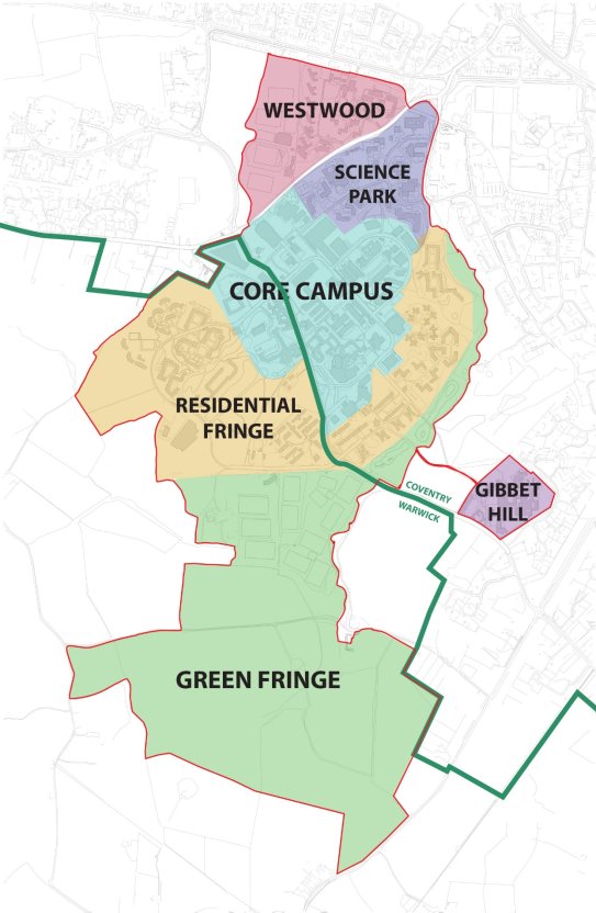
To assist in applying the strategic and design principles across campus, this SPD describes the character of six areas shown on Plan 14 and provides guidance on the future development of each should other proposals come forward within the period to 2033. These reflect the long term vision for the campus to ensure consistency of approach.
PLAN 14. CHARACTER AREAS
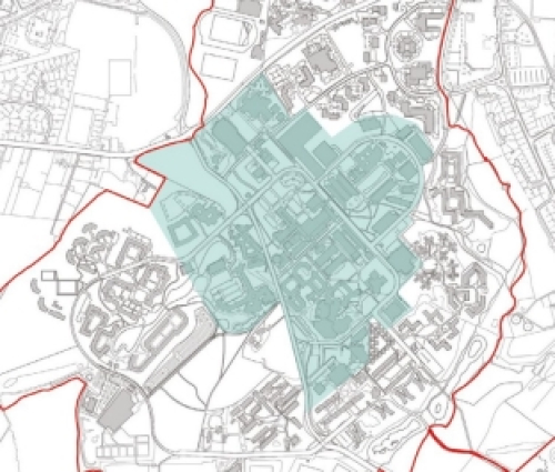
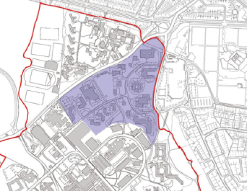
Campus Core
As set out in DP1, the majority of academic and teaching buildings are located in the campus core identified on plan 11. There have been some significant developments within this area over recent years including the Faculty of Arts Building which was shortlisted for the Stirling Prize in 2023. Over the period to 2033, two major new building clusters will be completed – the Science Precinct and Social Sciences Quarter – alongside the formation of a new University Green. This is part of a strategy to increase the density of the campus core whilst not compromising the quality of public spaces.
The aim is for the campus core to become more pedestrian friendly with one of the primary axes diverted through the heart of campus to create a pedestrian 'High Street' with active ground floors overlooking lively public spaces (see DP2 and DP4). In addition, vehicle traffic will be minimised through the campus core with improved opportunities for active travel and more shared-space environments (see DP3).
The mix of uses in the campus core will include primarily academic and teaching space, with student facilities and some student residential accommodation, more food and drink facilities, places for public engagement, innovation and what are called 'collision' and dwell spaces to help to maintain a sense of vibrancy at different times of the day. There is scope for higher-density and taller buildings within the campus core with locations for a number of landmark buildings to assist in legibility (see DP5).
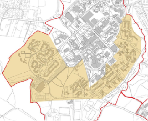
Residential Fringe
The residential fringe describes the south and east of the built-up area of campus which has a very different character. They are lower density, more domestic in scale and set within a mature landscape, in most cases bordering greenspace. Any new development will respect and enhance this character.
Development will be landscape-led, with buildings sitting within a preserved and enhanced mature landscape. However, a contemporary approach to architecture will be encouraged. The character and scale of any new buildings can vary between locations close to the campus core and the edges of campus. For example, the recent Cryfield development is sensitively designed across a range of heights to suit the landscape setting and respect mature trees.
The existing landscape character across this area will be maintained and existing trees protected. New and existing landscape will be managed to increase biodiversity (see DP6) and any new development will incorporate natural drainage features to achieve a greenfield runoff rate.
New residential accommodation will be designed to minimise car access and will include no new parking other than blue badge. Access will be via the one-way circulatory route around the campus (see DP3) to allow servicing, access to blue badge parking and emergency services.
This may be accompanied by Very Light Transport (VLT) to service residents and pedestrian and cycle routes will be enhanced where possible.
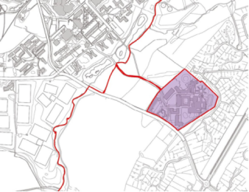
Gibbet Hill
Gibbet Hill is part of the campus core because it houses Warwick's Medical School, Biomedical and Life Sciences Buildings although it sits slightly apart from main campus, separated by Tocil Wood. It includes the recently completed Interdisciplinary Biomedical Research Building.
The vision for Gibbet Hill is to enhance the connection to main campus and consolidate the existing building stock, with better connectivity between buildings and public realm, the opportunity to provide new amenity space for students and potential opportunities to incorporate SUDs into the hard landscaping. A gateway feature such as a sculpture or a green entrance could mark the access from the road.
Any development at Gibbet Hill will be in the spirit of the contemporary architecture on campus whilst sensitively responding to heritage assets, namely the Grade II* Listed Houses for Visiting Mathematicians, and the pre-existing Gibbet Hill Farmhouse. Any new buildings will be more modest in scale than the rest of the Campus Core and will respect surrounding residential neighbourhoods.
Science Park
The Science Park is owned by the University and operated by a separate company. It is situated on the northern edge of campus adjoining Cannon Park District Centre. It is characterised by low density buildings in landscaped grounds providing accommodation for research and development businesses. It is one of the earliest Science Parks in the country.
There is scope for modernisation and intensification at the Science Park in future which may include development on surface level car parks and some redevelopment. It will continue to be focussed on business and research activities related to the University, not primarily academic or residential use.
Given the difference in uses, car parking at the Science Park is treated separately from the rest of campus and would be subject to separate traffic assessment.
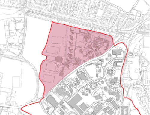
Westwood
The Westwood Campus was formerly the Coventry College of Education on a site across Kirby Corner Road, adjoining the residential suburb of Canley. It has had a mix of academic, conference, residential and sports uses, including the University Tennis Centre and running track.
As some of these uses are rationalised, the University is considering options for the future of the built-up part of Westwood and some redevelopment may come forward within the period to 2033. Uses are likely to include student accommodation, general housing and business/research uses linked to the Science Park but there are no firm plans.
Any development at Westwood will be more domestic in scale than the campus core, particularly around the edges of the site, to respond appropriately to neighbouring residential areas.
Development will respect the landscape features and setting of the site.
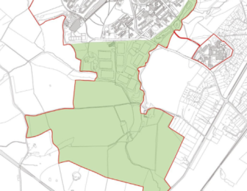
Green Fringe
The green fringe includes all those parts of the University's landholdings where no significant built development is anticipated, including the Tocil Wood Nature Reserve which wraps around the eastern side of main campus. The bulk of this area lies south of Leighfield Road, which sits within the Green Belt as defined in the Warwick District Local Plan and is characterised by sports pitches to the north of Cryfield Grange Road and agricultural land to the south. A significant strip of land is impacted by HS2.
The University has an ambition to create an Eco Park in this area, providing recreational opportunities for the campus and local communities by increasing accessibility for walking and cycling, improving biodiversity (see DP6) and potentially generating renewable energy to support the Net Zero Carbon strategy. Existing trees and habitats will be retained and enhanced.
Any proposals in the Green Fringe will have to satisfy relevant local plan policies including in respect of the Green Belt.