Draft University of Warwick Supplementary Planning Document
Design Principles
Guiding Future Development
To deliver on these strategic principles, the University has developed six key Design Principles to guide future development on campus. These are:
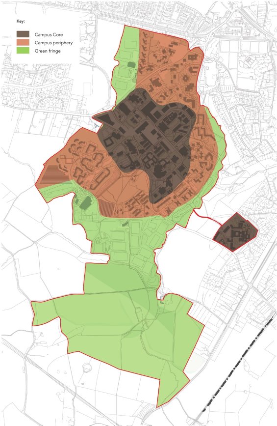
DP1: Campus Core and Periphery
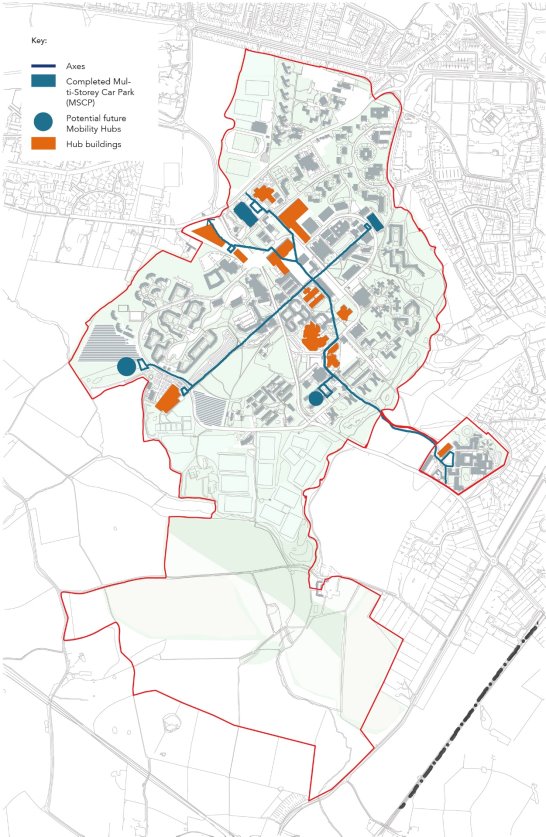
DP2: Axes and Hubs
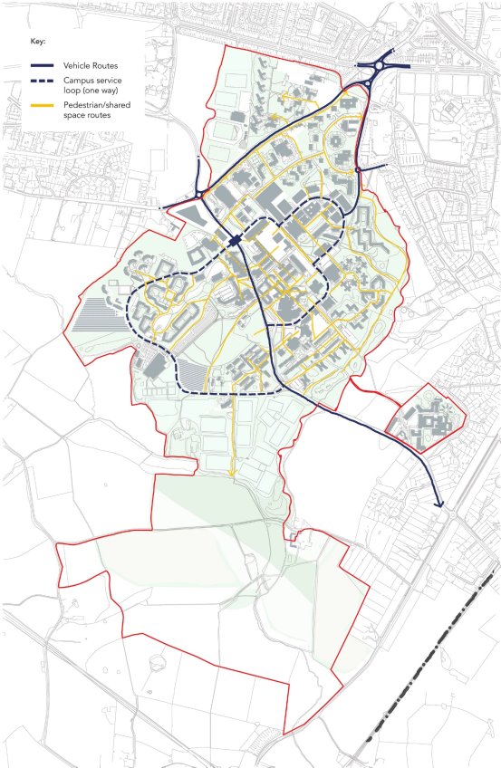
DP3: Pedestrian-Focussed
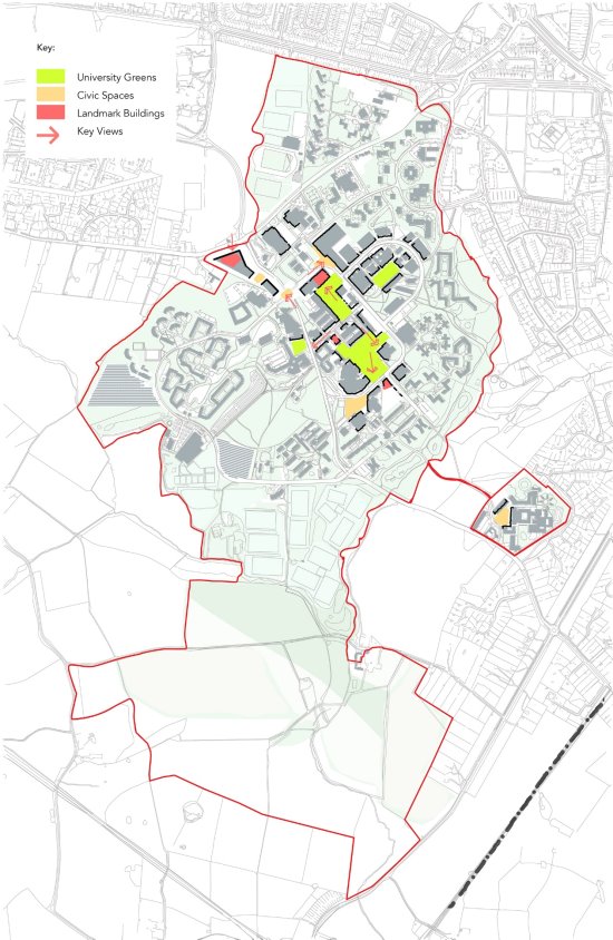
DP4: Active Public Spaces
DP5: Landmark Design
DP6: Integrating Nature
DP1: Campus Core and Periphery
A. Primarily academic uses will be concentrated within the core campus as defined on Plan 08, including Gibbet Hill.
B. Higher density development and taller buildings will be permitted in the Core Campus, subject to the application of other design principles (and relevant local policies) to ensure high quality.
C. The Campus Periphery will generally not be appropriate for higher density development, particularly in close proximity to sensitive greenspace or neighbouring residential areas.
PLAN 8. CAMPUS CORE AND PERIPHERY
DP2: Axes and Hubs
A. The focus of activity and movement around campus will be on two primary axes – one from University House to Gibbet Hill and the other from Academic Square to the Sports Hub.
B. These will connect a series of buildings, active public spaces and future mobility hubs (refer to page 22). where key University activities are based, and which provide access to a variety of travel options.
C. Car parking will be progressively removed from the core campus and, if replaced, this will be around the periphery (refer to Plan 15 on Transport and Movement).
PLAN 9. AXES AND HUBS
DP3: Pedestrian-Focussed
A. To transform the campus with a more pedestrian-focussed public realm, the University will create a one-way circulatory route to minimise traffic within the core campus whilst maintaining access to service yards, for blue badge parking and emergency services.
B. This will be supported by an extensive pedestrian and cycle network which will be expanded over time, supplemented by effective wayfinding additional detail on cycling measures is provided at page 20.
C. Where opportunities arise as part of new development, the pedestrian environment will be further enhanced through greater use of shared surfaces, downgrading of road space, environmental improvements and potential closures (refer to Plan 16).
PLAN 10. PEDESTRIAN FOCUSSED
DP4: Active Public Spaces
A. To support a more pedestrian-focussed campus around the primary axes and hubs, the University will create more active public spaces for users of campus to enjoy a greater sense of community, including formal squares and greenspaces.
B. New developments will incorporate and/or support active public spaces including, where suitable, active frontages within buildings for small scale ancillary retail, study areas, informal meeting space or other community uses.
C. As part of the Science and Engineering Precinct development, a new University Green will be created between University Road and Library Road at the junction of the two primary axes.
DP5: Landmark Design
A. The design of new and refurbished buildings will reflect the character and modern vernacular of the University campus, differentiating scale and design between the Core and Periphery
B. Buildings in locations indicated on Plan 11 will be designed to provide landmarks and visual markers at the end of views within the campus to contribute to a sense of place and clear identity.
C. Materials will be selected to provide the right balance between coherence and contrast so that buildings fit harmoniously with their surroundings, but also have emphasis and interest where necessary.
PLAN 11. ACTIVE PUBLIC SPACES
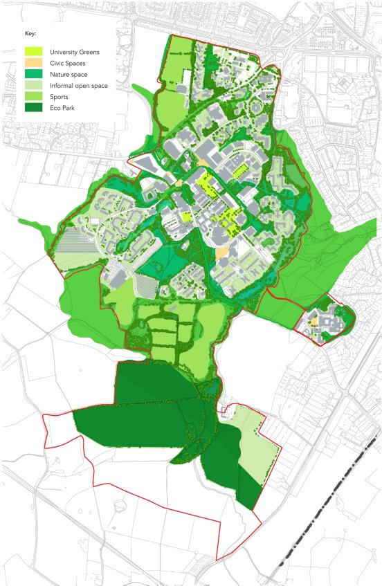
DP6: Integrating Nature
A. The formal and informal landscapes of the campus contribute to its character and should, wherever possible, be incorporated into and enhanced by new development.
B. This will include a 'layered'[5] approach to green and blue infrastructure to ensure the integration of nature and the creation of connected habitats and ecological corridors such as green roofs, green walls and rain gardens.
C. Outside of the core campus, this will take a more informal and naturalistic approach to enhance biodiversity (see section on Ecology and Biodiversity).
D. Tree planting will be designed to add structure to the public realm and contribute to the identity and character of spaces and routes.
E. Subject to the return of land from HS2 and decisions about future infrastructure, the University will create an 'Eco-Park' in the south of campus comprising ecological, recreational and potentially energy generating uses in accordance with relevant Green Belt policy.
PLAN 12. INTEGRATING NATURE
[5] A 'layered' approach to landscape means a 3-dimensional combination of planting types and habitat features, such as an upper layer of roof gardens, green walls and trees, alongside a middle layer of hedgerows and shrubs, and a lower layer which may include a diverse mix of species and planting types, for example perennial planting, raingardens, meadow grassland and bulb planting within grass. The intent being to create species diversity and a more connected environment for wildlife.