Draft University of Warwick Supplementary Planning Document
The Campus
A UK top 10 institution
The University of Warwick is a world leading and UK top 10 institution with over 25,000 students and 5,500 members of staff, generating an economic impact of in excess of £1bn with significant benefits for the West Midlands region and its economy.
It occupies a main campus set in nearly 300 hectares on the edge of Coventry and the Warwickshire countryside.
The campus plays a significant role in south-west Coventry, with the renowned Arts Centre and recently completed Sports and Wellness Hub providing community benefits. The campus is accessible to local people and there are routes which cross the area including the Sustrans cycle route to Kenilworth providing connections to the countryside.
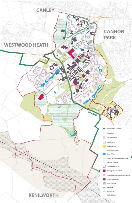
In previous masterplans the campus has been divided into a series of 'character areas' including Central Campus East and West (either side of Gibbet Hill Road), Westwood (north of Kirby Corner Road) and Gibbet Hill (close to Kenilworth Road). The University has refreshed its internal masterplan during 2023, based on their emerging Vision for the campus by 2050. The internal masterplan takes a slightly different approach which the SPD reflects:
- Core Campus: The masterplan seeks to concentrate new academic development within the core of the campus (defined in DP1 on page 12). Over time, the aim is to change the character of the public realm in this area so it is less dominated by cars and more pedestrian-focussed.
- This includes Gibbet Hill which is home to Warwick's Medical School and Life Sciences faculty and sits slightly apart from main campus separated by Tocil Woods.
- Periphery: around the core campus, to the south and east, are areas of primarily student residential housing which are different in character, less dense and set in most part within a mature landscape setting.
- To the north is the Westwood campus which comprises a mix of academic, conference, sports and residential accommodation that is likely to see change in the medium to long term; and the Science Park, which is wholly owned by the University and is operated by a separate management company.
- Green Fringe: The area to the south of the campus sits within designated Green Belt and is characterised by sports pitches and agricultural land, part of which is affected by the construction of HS2.
Beyond the campus, the surrounding neighbourhoods include residential suburbs on the edge of Coventry - Cannon Park, including the shopping centre which also serves the University community, Canley and Westwood Heath, the area around Moreall Meadows and Kenilworth Road, and Burton Green, which is predominately in Warwick District. To the south, beyond the HS2 route, is the town of Kenilworth.
PLAN 3. EXISTING CAMPUS