Publication Draft
2. Development Strategy
Introduction
2.1 This chapter sets out the Development Strategy for the growth of the District through to 2029 along with the strategic policies and site allocations to support the delivery of the strategy. The Strategy has been designed to deliver the vision and the objectives set out in the previous chapter.
2.2 The Development Strategy for Warwick District is based on the overarching policies set out below.
Strategic Policies
(7) STRATEGIC POLICY DS1 : Supporting Prosperity
We will provide for the growth of the local and sub-regional economy by ensuring sufficient and appropriate employment land is available within the District to meet the existing and future needs of businesses.
Explanation
2.3 It is part of the Council’s vision for the District to facilitate the growth of the local economy and to provide for the growth of, and changes within, the local population. This approach is consistent with national policy which requires the Local Plan to include strategic policies to deliver the homes and jobs needed in the area and to support economic growth by planning proactively to meet the development needs of businesses and to support an economy fit for the 21st century.
2.4 Providing land for business to grow or relocate to the District is a key component of good planning. In doing this, this Plan seeks to maintain a balance between the number of jobs in the District and the working age population and boosting economic development and the supply of jobs.
(28) STRATEGIC POLICY DS2 : Providing the Homes the District Needs
We will provide in full for the Objectively Assessed Housing Need. We will ensure new housing delivers the quality and mix of homes needed in the District including:
-
affordable homes;
-
a mix of homes to meet identified needs including homes that are suitable for elderly and vulnerable people; and
-
sites for gypsies and travellers.
Explanation
2.6 National policy requires local planning authorities to boost significantly, housing supply. A key element in this is developing an evidence base to objectively assess housing need and ensuring that this Objectively Assessed Need is met in full for both market and affordable housing. National policy also emphasises the importance of delivering a wide choice of homes by planning for a mix of housing based on current and future demographic and market trends. The Council has undertaken a Joint Strategic Housing Market assessment with the other local authorities in the Coventry and Warwickshire Sub-region. This provides the basis for establishing the District’s Objectively Assessed Need.
2.7 The Council’s ambitions align with national policy in recognising that it is important that housing needs are met for all. This involves ensuring a good supply of development sites for new housing is available and that this is supported by clear policies which require affordable housing and an appropriate mix of housing to be developed across the District. This approach also recognises that new housing is not only important in meeting the changing and growing needs of the District’s population, but also in supporting the local economy by encouraging investment and ensuring that homes are available to complement the economic and business needs and ambitions for the District.
(22) STRATEGIC POLICY DS3 : Supporting Sustainable Communities
2.5 We will promote high quality new development including:
delivering high quality layout and design which relates to existing landscape or urban form and, where appropriate, is based on the principles of garden towns, villages and suburbs;
caring for our built, cultural and natural heritage;
regenerating areas in need of improvement;
protecting areas of significance including high quality landscapes, heritage assets and ecological assets;
delivering a low carbon economy and lifestyles and environmental sustainability.
We will expect development which enables new communities to develop and sustain themselves. As part of this we will provide for the infrastructure needed to support communities and businesses including:
physical infrastructure (such as transport and utilities);
social infrastructure (such as education, sports facilities and health);
green infrastructure (such as parks, open space and playing pitches).
Explanation
2.9 It is important that new development is high quality. This underpins sustainable and cohesive communities and engenders a strong sense of civic pride. It enables new housing and new employment to develop into thriving communities for local residents and businesses. High quality development not only enhances people’s lives, but also enhances the reputation of the areas and therefore brings associated economic benefits. Good design is good business.
2.10 National policy attaches great importance to good design and recognises that this contributes positively to making places better for people. It seeks to ensure that local planning authorities have robust and comprehensive policies regarding the quality of development. In doing this it is important to recognise the need to integrate new development into the natural, built and historic environment.
2.11 Within the District, the environment is good quality and there are natural and historic features that need to be carefully protected. However, there is also scope to improve the quality of development and specifically, the Council is aiming to do this by ensuring new development recognises the high quality we already have in the District, delivering new strategic development sites based on the principles of garden towns, villages and suburbs. To this end, the Council has produced a prospectus which illustrates the principles of such development.
2.12 New development needs to be accompanied by high quality and timely infrastructure to enable new communities to have access to the facilities and services they need and to ensure that the impacts of new development on existing communities are properly addressed.
(40) STRATEGIC POLICY DS4: Spatial Strategy
Allocated Housing and Employment will be distributed across the District to take account of the following:
-
in the first instance, allocations will be directed to previously developed land within the urban areas and in particular those areas where there is greatest potential for regeneration and enhancement;
-
where greenfield sites are required for housing, they should be located on the edge of urban areas in sustainable locations close to areas of employment or where community facilities such as shops, bus services, medical facilities and schools are available or can be made available.
-
where greenfield sites are required for employment, they should be allocated in locations which are suitable for the needs of 21st century businesses, accessible via a choice of transport modes and are in close proximity to existing or proposed housing;
-
limiting development on sites which would lead to coalescence of settlements to ensure settlement identity is retained;
-
sites which have a detrimental impact on the significance of heritage assets will be avoided unless suitable mitigation can be put in place;
-
areas assessed as high landscape value or other highly sensitive features in the natural environment will be avoided; and
-
taking the national Green Belt policy in to account, sites in the green belt will be limited to those locations where exceptional circumstances can be justified. The following will be taken into account in considering exceptional circumstances:
- the availability of alternative suitable sites outside the Green Belt;
- the potential of the site to meet specific housing or employment needs that cannot be met elsewhere;
- the potential of the site to support regeneration within deprived areas; and
- the potential of the site to provide support to facilities and services in rural areas.
Explanation
2.13 In arriving at its spatial strategy for housing and employment allocations, the Council has taken account of national planning policy, the Strategic Economic Plan for Coventry and Warwickshire, public consultation results, the evidence that has been prepared to support the Local Plan and the sustainability appraisal.
2.14 The evolution of the Plan and its vision, strategy and objectives are described in Chapters 3 and 4. This shows how public consultation, emerging evidence, sustainability considerations and sub-regional factors have helped to shape the Plan’s approach.
2.15 The Spatial Strategy has been used to shape the site allocations set out in policies DS9, DS10, DS11, DS12, DS13, DS14 and DS16. It will continue to be used to help shape development ambitions and proposals to be set out in future Development Plan Documents.
References
- National Planning Policy Framework
- National Planning Practice Guidance
- Coventry and Warwickshire Strategic Economic Plan
Policies and Proposals
2.16 The remainder of this document sets out this Plan’s policies, along with explanations to help interpret the policies. For clarity, it should be noted that all relevant policies apply to development proposals and therefore any single policy cannot be used without giving due consideration to the other policies within this Plan.
2.17 The following specific development strategy policies are set out to deliver the Development Strategy described in the four overarching policies above
(11) DS5 Presumption in Favour of Sustainable Development
When considering development proposals the Council will take a positive approach that reflects the presumption in favour of sustainable development contained in the National Planning Policy Framework. It will work proactively with applicants to find solutions which mean that proposals can be approved wherever possible, and to secure development that improves the economic, social and environmental conditions in the area.
Planning applications that accord with the policies in this Local Plan (and, where relevant, with policies in neighbourhood plans) will be approved without delay.
Where there are no policies relevant to the application or relevant policies are out of date at the time of making the decision then the Council will grant permission unless material considerations indicate otherwise – taking into account whether:
Any adverse impacts of granting permission would significantly and demonstrably outweigh the benefits, when assessed against the policies in the National Planning Policy Framework taken as a whole; or
Specific policies in that Framework indicate that development should be restricted.
Explanation
2.18 The Government expects the planning system to actively encourage growth, giving local people the opportunity to shape communities, whilst providing sufficient housing to meet local need and supporting economic activity. This approach is entirely consistent with the Council’s vision and aspirations for the District. In this context, it is important that the planning system does everything possible to support economic growth and sustainable development.
2.19 The National Planning Policy Framework sets out the presumption in favour of sustainable development and the need for sustainable economic growth.
(89) DS6 Level of Housing Growth
The Council will provide for 12,860 new homes between 2011 and 2029
Explanation
2.20 The Joint Coventry and Warwickshire Strategic Housing Market Assessment (2013) objectively assessed the future housing needs of the Housing Market Area and the six local authority areas within it. Warwick District aims to meet its Objectively Assessed Need for housing by providing 12,860 new homes between 2011 and 2029.
(61) DS7 Meeting the Housing Requirement
The housing requirement of 12,860 new homes between 2011 and 2029 will be met from the following categories:
Sites completed between 2011 and 2013 |
406 |
Sites with outstanding planning permission at 1st April 2013 |
1,906 |
Sites with planning permission granted between 1st April 2013 and 31st December 2013 |
1,317 |
An allowance for windfall sites coming forward in the plan period |
2,485 |
Small Urban sites assessed in the Strategic Housing Land Availability Assessment as being suitable |
393 |
Consolidation of existing employment areas and canal-side regeneration |
269 |
Sites allocated in this Plan |
6,188 |
Total |
12,964 |
Explanation
2.21 The Council’s approach to identifying land for housing is set out in the Spatial Strategy above. Taking account of completions, committed sites, and an allowance for windfall sites, the Council needs to identify sites for an additional 6,746 new homes. This plan identifies sites for a potential 6,900 homes. This allows for an element of flexibility in the event that some sites fail to come forward or are delivered with reduced capacities than that allowed for in the plan.
2.22 In addition to completions and commitments, the Council has made an assessment of windfall sites which are likely to emerge based on past trends and taking into account likely changes to those trends. Windfall sites have consistently played an important role in the housing supply of the District. Between 2002 and 2013 they averaged 191 units a year (excluding garden land development), even with 3.5 years of a housing moratorium.
2.23 The identified sites include small urban brownfield sites which are assessed as being suitable and available for development in the Strategic Housing Land Availability Assessment and a number of broad areas where new housing could play a role in regeneration schemes. The balance of housing is provided on allocated brownfield and greenfield sites across the District, based on the priorities set out in the spatial strategy.
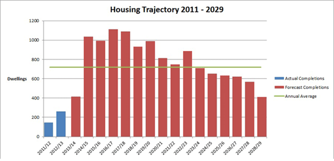
2.24 The following Housing Trajectory shows the timeline for the delivery of housing across the plan period in relation to the annual average of the total requirement.
(10) DS8 Employment Land
The Council will provide for a minimum of 66 hectares of employment land to meet local need during the plan period
Explanation
2.25 It is important that the right amount and type of local employment land is provided during the plan period. Local employment land means land to meet the needs of the District and support existing and growing sectors. National policy states that local authorities should demonstrate a clear understanding of the business needs within the economic markets operating in and across their area. To achieve this they should develop and maintain a robust evidence base to understand both existing business needs and likely changes in the market in their area. This evidence should be used to assess the need for land and floor space (both in terms of quality and quantity) and the existing and future supply of land available to meet these needs. Reviews of land available for economic development should be undertaken at the same time as the Strategic Housing Market Assessment and include a reappraisal of previously allocated land. Local authorities should work with neighbouring authorities and the Local Enterprise Partnership in preparing this evidence.
2.26 An Employment Land Review update was undertaken in May 2013 to identify the level and type of employment land required during the plan period. This took account of future projections for the local economy by different sectors and assessed the capacity for the District’s existing and committed employment land to meet current and future requirements over the plan period. A Joint Employment Land Review was undertaken with the Coventry and Warwickshire Local Enterprise Partnership and 6 neighbouring local authorities in Coventry and Warwickshire to provide a quality check of existing employment land studies and identify the need for an employment site of sub regional significance and potential options for accommodating any need.
| Employment Land Requirement | |
|---|---|
| Demand | Hectares |
Employment land requirement 2011-30 |
36 |
Margin to provide flexibility of supply |
16.5 |
Potential replacement for redevelopment of existing employment areas |
13.5 |
Total gross employment requirement (demand) |
66 |
2.27 There is a need for in the region of 66 hectares of employment land during the plan period to meet local employment needs. This allows flexibility in the supply ensuring there is a range of employment land and buildings to provide a choice of sites.
2.28 Replacement provision of 13.5 hectares of employment land is being provided to take into account the redevelopment of poor quality employment land. The Council has undertaken a review of industrial estates within the District and identified the following areas as being less capable of providing the right type or location of employment land to meet future business needs:
-
Sydenham Industrial Estate, Royal Leamington Spa
-
Cape Road / Millers Road, Warwick
-
Montague Road Industrial Estate, Warwick
-
Common Lane, Kenilworth
2.29 These industrial estates arose to accommodate small scale local manufacturing and are characterised by building stock which no longer reflects the requirements of many businesses. Decline in manufacturing and the fact that modern manufacturing processes have resulted in the need for smaller footprint buildings means levels of vacancy on these sites will increase over time. In addition these industrial estates do not have easy access to the strategic road network and being located within or adjacent to residential areas do not offer the most suitable environment for certain employment uses. Three of these areas are located adjacent to the Canal and therefore will be brought forward through the Canalside Regeneration Area DPD (see policy DS17).
2.30 Taking account of land completed since 2011 and the supply of available employment land (set out in Policy EC3) in the region of 19 to 29 hectares of new employment land allocations are needed. This takes into account uncertainty surrounding some of the assumptions used to inform the modelling.
(6) DS9 Employment Sites to be Allocated
To meet the employment land needs of the District, an additional 19.7 hectares of employment land for B class uses is allocated at the following strategic sites, as identified on the Policies Map:
| Ref | Site | Size | Uses |
|---|---|---|---|
(2) E1 |
Land North of Gallows Hill, Warwick |
8 hectares |
B1 and B2 |
(1) E2 |
Land at Thickthorn, Kenilworth |
8 hectares |
B1 and B2 |
(1) E3 |
Opus 40, Birmingham Road, Warwick* |
3.7 hectares |
B1 |
Total |
19.7 hectares |
* This is a previous employment commitment for which planning permission has expired
An allowance of 6.5 hectares of employment land to meet local needs will be accommodated at the allocated sub-regional employment site (see policy DS16)
Explanation
2.31 16 hectares of employment land will be provided as part of the strategic urban extensions allocated in this Local Plan at Thickthorn in Kenilworth and South of Warwick and Leamington.
2.32 At Thickthorn employment land will be provided as part of the wider residential led development. The supply of good quality employment land in Kenilworth is limited and the site adjacent to the A46 provides the opportunity for mixed B1 and B2 employment development to meet local and the wider needs of the District. Other non B class uses will not be considered acceptable.
2.33 Employment land will be provided adjacent to Warwick Technology Park on land north of Gallows Hill identified on the policies map. This will build on existing good quality employment provided at the Technology Park supporting its long term future and taking advantage of the sites proximity to the strategic road network. This can also provide opportunities for the clustering of advanced manufacturing and research and development in line with wider sub-regional objectives. This site offers the best location in terms of the impact of employment development on the surrounding landscape, the setting of historic assets and the attractiveness of this site to the market.
2.34 8 hectares has been allocated at each of these sites as this represents an allocation of sufficient size to meet a variety of demands. This is particularly important as both the allocated sites have the potential to deliver land for B1 and B2 uses.
2.35 The Council will also take forward the previous employment land commitment at Opus 40, Birmingham Road, Warwick for which planning permission has expired. The 2013 Employment Land Review identified this site as a high quality office park, in a good, accessible and prominent location.
2.36 Policy DS16 makes provision for a sub-regional employment site in the north east of the district. If development similar to that included in the planning application is provided it is estimated that 6.5 hectares of existing employment land will be released through displacement. From this it is reasonable that the site could provide for 6.5 hectares of the District’s local employment demand.
(81) DS10 Broad Location of Allocated Housing Sites
Urban Brownfield sites |
1,330 |
Greenfield sites on the edge of Kenilworth |
850 |
Greenfield sites on the edge of Warwick, Leamington and Whitnash |
3,245 |
Sites within Growth Villages and the rural area |
763 |
Total |
6,188 |
Explanation
2.37 The spatial strategy aims to meet housing needs of the District by allocating sites across the towns and in the more sustainable villages. The Strategic Housing Land Availability Assessment identifies suitable and available sites across the four towns and adjacent to villages. In line with the Council’s aim of meeting housing needs in sustainable locations, the site selection exercise favoured sites, firstly, within the urban areas and then on the edge of urban areas. These locations are well placed to make best use of, and improve, the existing transport infrastructure and accessibility to jobs and services. Sites on the edge of urban areas are of sufficient size to deliver supporting services including schools, GP services and local centres as appropriate.
2.38 In selecting sites on the edge of urban areas, non-Green Belt sites are favoured over Green Belt sites where possible. However, where there are no suitable non-Green Belt alternatives, sites are removed from the Green Belt to enable development to take place. This applies to land to meet the needs of Kenilworth, some of the villages and land on the edge of Lillington to assist in the regeneration of the area.
2.39 The Growth Villages were identified in the Settlement Hierarchy Report (2014). They are assessed as being the most sustainable rural settlements according to a range of sustainability indicators, including the availability of local services and facilities as well as accessibility to larger settlements.
2.40 Focusing rural housing development in the District’s most sustainable village locations, provides an opportunity to assist in re-balancing the local housing markets in these villages and to provide much needed affordable housing and market homes for local residents. With new housing comes the positive benefits of helping support and sustain local services, facilities and businesses.
(62) DS11 Allocated Housing Sites
The following sites, as shown on the Policies Map, will be allocated for housing development and associated infrastructure and uses:
| Ref | Site | Number of Dwellings | Area of Emp. Land | Infrastructure Requirements and Other Uses |
|---|---|---|---|---|
Former Sewage Works, south of Harbury Lane |
215 |
0 |
Country Park |
|
(4) H09 |
Kenilworth School Site |
250 |
0 |
|
(1) H10 |
Station Approach, Leamington |
220 |
0 |
|
Land at Montague Road |
140 |
0 |
||
(4) H12 |
Kenilworth VI Form College |
130 |
0 |
|
(1) H13 |
Soans Site, Sydenham Drive |
100 |
0 |
|
Riverside House |
100 |
0 |
||
Leamington Fire Station |
60 |
0 |
||
(1) H16 |
Court Street |
75 |
0 |
|
Garage Site, Theatre Street |
20 |
0 |
||
(6) H01 |
Land West of Europa Way |
1,190 |
8ha |
Extended Secondary School, Primary School, Health Facilities, Local Centre, other Community Facilities. |
(6) H02 |
Land south of Harbury Lane (excluding former sewage works) |
1,505 |
0 |
Primary Schools (x2), Local Centre, other Community Facilities, Country Park |
(3) H03 |
East of Whitnash/South of Sydenham |
300 |
||
(12) H04 |
Red House Farm |
250 |
||
(11) H06 |
East of Kenilworth (Thickthorn) |
760 |
8ha |
Local Centre |
(2) ED2 |
East of Kenilworth (Southcrest Farm) To comment on ED2, please go to DS12 below |
0 |
0 |
Site for new Secondary School and 6th Form Centre |
(5) H07 |
Crackley Triangle |
90 |
0 |
|
(1) H08 |
Oaklea Farm, Finham |
20 |
0 |
|
(2) Baginton |
||||
(2) H19 |
Baginton – Land north of Rosswood Farm |
35 |
0 |
|
(1) Barford |
||||
(2) H20 |
Barford – Land south of Barford House |
8 |
0 |
|
Barford – Former Sherbourne Nursery |
60 |
0 |
||
(3) H22 |
Barford – Land off Bemridge Close |
12 |
0 |
|
(1) Bishops Tachbrook |
||||
(6) H23 |
Bishops Tachbrook – Land south of the school |
150 |
0 |
|
(6) Burton Green |
||||
(4) H24 |
Burton Green – Burrow Hill Nursery |
60 |
0 |
|
(1) Cubbington |
||||
(1) H25 |
Cubbington – Allotment Land, Rugby Road |
35 |
0 |
|
(2) H26 |
Cubbington – Opposite Willow Sheet Meadow |
65 |
0 |
|
(4) Hampton Magna |
||||
(25) H27 |
Hampton Magna – South of Arras Boulevard |
100 |
0 |
|
(2) Hatton |
||||
(35) H28 |
Hatton Park – North of Birmingham Road |
80 |
0 |
|
(7) Kingswood |
||||
(2) H29 |
Kingswood – Meadow House |
10 |
0 |
|
(4) H30 |
Kingswood – Kingswood Farm |
10 |
0 |
|
(2) H31 |
Kingswood – South of The Stables |
6 |
0 |
|
(2) H32 |
Kingswood – R/O Brome Hall Lane |
12 |
0 |
|
(2) H33 |
Kingswood – West of Mill Lane |
5 |
0 |
|
(4) Leek Wootton |
||||
(4) H34 |
Leek Wootton – The Paddock |
30 |
0 |
|
(3) H35 |
Leek Wootton – East of Broome Close |
5 |
0 |
|
(4) H36 |
Leek Wootton – Former Tennis Courts |
5 |
0 |
|
(1) H37 |
Leek Wootton – Car park East of The Hayes |
5 |
0 |
|
(1) Radford Semele |
||||
(2) H38 |
Radford Semele – North of Southam Road |
50 |
0 |
|
(1) Other rural sites |
||||
(1) H18 |
Former Aylesbury House, Hockley Heath |
20 |
0 |
|
Explanation
2.41 All sites were initially assessed for their suitability for housing in the Strategic Housing Land Availability Assessment. Sites were then appraised using the Council’s Site Selection Methodology which considered the suitability of each site against the following information:
-
The Sustainability Appraisal
-
Green Belt Assessment
-
Landscape Character Assessment
-
Historic Setting Assessment
-
Strategic Flood Risk Assessment (SFRA Level 1)
-
Habitat Assessment, and
-
Strategic Transport Assessment
2.42 Sites were also assessed against the potential to lead to a coalescence of settlements and the loss of employment land.
Urban Brownfield Sites
2.43 A number of brownfield sites will become available as a result of the rationalisation or replacement of public sector land and services. The two Kenilworth School sites, Riverside House and Leamington Fire Station will become available when alternative premises have been provided for the existing users. The land at Montague Road is available in part and capable of being developed in phases.
2.44 Land at Station Approach is partly vacant and the site is being brought forward by a Joint Venture between the Council and a Housing Provider with grant funding from the Homes and Communities Agency. The Council is also pro-actively bringing forward the site at Court Street.
2.45 The Soans site is currently being assembled for housing development utilising an area where vacancy rates in existing industrial premises are high. The site forms part of a wider area that has potential to deliver canalside regeneration through the support of policy DS14.
2.46 The site of the former sewage works is set back from Harbury Lane and is sandwiched between the sites at Grove Farm and Heathcote Farm. Thus the site, which requires extensive remediation, cannot come forward until a suitable access from an adjoining site is made available.
2.47 The site at Aylesbury House is a small brownfield site in the Green Belt, south east of Hockley Heath, with potential for some redevelopment and infilling around the original Aylesbury House.
2.48 The small site at Theatre Street is likely to become vacant within the plan period and provide an opportunity to supplement an existing planning permission and to redevelop and improve this prominent site on the edge of Warwick Town Centre.
Greenfield Sites
2.49 The strategic urban extension to the south of Warwick and Leamington comprises of land to the west of Europa Way and land to the south of Harbury Lane. The area will deliver up to 2,695 homes along with extended secondary school facilities, three primary schools, employment land, local GP services, shops, community facilities and an important buffer of open space to the south to be delivered as a Country Park.
2.50 The site at Whitnash East provides an extension to the committed site located off St. Fremunds Way, to the south of Sydenham. The site will deliver up to 300 homes along with an ecology and landscape corridor adjacent to Whitnash Brook and a partial rebuild and extension of Campion School which will enable access to be provided.
2.51 Land at Red House Farm forms an extension to Lillington, one of the most deprived neighbourhoods in Warwickshire. The urban extension will provide for up to 250 new homes, of different types and tenures, and support regeneration in Lillington itself.
2.52 The strategic urban extension to the east of Kenilworth, at Thickthorn, will provide for up to 760 new homes and 8 hectares of employment land. Kenilworth has seen relatively little new development in the last 20 years and the new housing which has been provided has been largely at the expense of employment land. This development, therefore, provides the opportunity to deliver new housing and employment in a sustainable location along with the necessary supporting facilities of a primary school, GP surgery, local centre and open space. Later in the plan period a new secondary school will be provided on land to the north at Southcrest Farm. A further 90 homes will be provided on a site to the north of the town at Crackley.
Village Allocations
2.53 The majority of the village housing allocations are located on the edge of the existing limits to the built up areas of the village in locations which will provide natural extensions. Large sites of over 50 dwellings will be brought forward in phases (see Policy H10) so that the growth of the village can take place more slowly and in proportion to the size of the settlement. This will provide a greater opportunity for the new communities to integrate into the life of the village and for housing to meet local needs which will change over the lifetime of the Plan.
(15) DS12 Allocation of Land for Education
Land at Southcrest Farm, Kenilworth and land at Myton, as shown on the Policies Map, is allocated for educational uses and other compatible uses (see policy HS5). This includes, on each site, the provision of a secondary school, 6th form centre and primary school.
Explanation
2.54 Provision of education facilities is a central element of delivering sustainable communities. The housing proposals set out in this Plan require the provision of additional capacity for all age groups, as well as for Special Educational Needs.
2.55 Part of this additional capacity requirement can be met within existing schools or by expanding schools within their current footprint. However, new sites are required as follows:
2.56 Kenilworth Secondary School and 6th Form: the existing school sites are allocated for housing with Policy DS11. The school is seeking to locate all its facilities on a single site. Further, the additional housing proposed in the Kenilworth priority area means that the school needs additional capacity if it is to continue to offer the educational choice it currently offers. For these reasons, a new site for a secondary school in Kenilworth is required. In addition, the additional housing allocated in the Kenilworth area requires the provision of a new primary school. The land at Southcrest Farm, as shown on the Policies Map, is therefore allocated for educational purposes and other compatible uses as defined by policy HS5.
2.57 Myton Area: there is insufficient capacity in existing primary and secondary schools to support the development proposed to the south of Whitnash and Warwick. It is therefore necessary to provide new and expanded educational facilities in this area. In total 3 new primary schools are required. Two of these will be provided to the south of Harbury Lane as set out in Policy DS15. The third primary school, along with new and partially refurbished secondary and sixth form facilities, will be provided within the area on the Policies Map set aside for education purposes and other compatible uses as defined by policy HS5. This will enable Myton School to enlarge its footprint to provide the additional capacity required and deliver a new integrated education campus.
(10) DS13 Allocation of Land for a Country Park
Land adjoining the Tach Brook, as shown on the Policies Map, will be allocated for a Country Park
Explanation
2.58 The Green Infrastructure Study 2010 and Green Space Strategy 2012 identified gaps in Accessible Natural Green Space. This is particularly the case in the southern part of the Warwick, Leamington and Whitnash urban area. This area is also more limited in terms of pedestrian access to the wider network of footpaths in the countryside. Therefore, the Council considers that it is appropriate to address this deficiency in particular given the scale and location of development proposals in this part of the District. Furthermore, a new country park in this location will provide a substantial, and permanent, landscape buffer between the edge of the urban area and the village of Bishop’s Tachbrook, whilst offering opportunities for all communities to enjoy this new asset.
2.59 The park will be a multifunctional green infrastructure asset to:
-
Provide a strong ‘green buffer’ between the North of Bishop’s Tachbrook and the southern edge of new development sites off Harbury Lane. This may include minimising the visual impact of development and softening the edge of new housing schemes.
-
Promote ecology and habitat diversification in a landscape which has historically been associated with modern farming and other uses (part of the Seven Trent site for example).
-
Potentially play a role in flood alleviation, particularly considering the close proximity of a significant numbers of new houses.
-
Provide a functional park facility which is well connected to new developments, in terms of access points and the wider walking and cycling infrastructure. While the park may have a defined character it is also part of a wider brook valley / green corridor.
-
Provide a park facility of an appropriate scale to support informal leisure activities for people living within the wider south of Leamington / Warwick catchment area, who currently have relatively less accessible natural green space and limited access to the wider countryside.
(4) DS14 Allocation of Land for a Community Hub
Land at Myton, adjoining Warwick Technology Park, as shown on the Policies Map, will be allocated as a Community Hub to provide the following infrastructure and services:
-
local retail facilities;
-
a community meeting place;
-
community sports complex and complementary uses; and
-
a medical centre.
Explanation
2.60 The community hub will provide a focus for a range of community facilities which can support the new communities being established to the south of Warwick.
2.61 Local retail facilities are important in reducing the need to travel and in encouraging walking and cycling. Such facilities perform an important role in enhancing quality of life and sense of place. These facilities should provide for a convenience store of no more than 500sq. m gross floorspace. A number of other smaller stores may also be provided.
2.62 A community meeting place is important in providing a location for community activities and meetings. This could take the form of a community centre, place of worship or a multi-functional facility.
2.63 The community sports complex will provide an opportunity for new sports facilities to be developed. This could also include provision of a small stadium with complementary uses, should such a scheme be viable.
2.64 The medical centre will provide capacity for 5 general practitioners as required by the Care Commissioning Group to meet the needs of the new communities to the south of Warwick.
2.65 The facilities and services required in this policy may be integrated to enable more efficient use of land.
(11) DS15 Comprehensive Development of Strategic Sites
The Sites to which this policy applies are (as shown on the Policies Map):
-
South of Harbury Lane, including the former sewage works ;
-
West of Europa Way;
-
Red House Farm;
-
Whitnash East/South of Sydenham; and
-
Thickthorn
Proposals for all or part of the allocated sites detailed above will be approved where they take full account of a comprehensive development scheme for the whole site. The comprehensive development scheme will take the form of either a Development Brief or a Masterplan to be approved by the Local Planning Authority.
The Development Brief or Masterplan should address the criteria set out in Policy BE2 and, for the sites set out below, should provide for the delivery of infrastructure and services which as a minimum should include the following:
| Site | Infrastructure and Services |
|---|---|
Land South of Harbury Lane |
2 new primary schools Country Park (see Policy DS13) A community meeting place Retail facilities: a convenience store of no more than 500sq. m gross floorspace. A number of other smaller stores may also be provided |
Land at Myton / West Europa Way |
Secondary school, sixth form facility and primary school (see Policy DS12) Community hub (see Policy DS14) Health facilities (See Policy DS14) |
Thickthorn |
A community meeting place Retail facilities: a convenience store of no more than 500sq. m gross floorspace. A number of other smaller stores may also be provided |
The Development Brief or Masterplan for the sites South of Harbury Lane, should also take account of, and ensure alignment with, the proposals for the site West of Europa Way, and vice versa.
Explanation
2.66 The sites listed within this policy are the allocated strategic urban extensions. A number of these sites are in multiple ownership. This policy seeks to ensure that development on these sites comes forward within the context of an appropriate comprehensive scheme. The Development Brief or Masterplan should clearly demonstrate how the mix of uses and the infrastructure requirements set out in policy DS7 (and articulated further within the Policies Map and Infrastructure Delivery Plan) will be planned for and delivered to ensure the development is sustainable and meets the policies set out elsewhere in this Local Plan.
2.67 Without a comprehensive development scheme, the delivery of infrastructure and services (such as schools, open space, roads, transport facilities, community facilities and local centres) cannot be guaranteed or properly integrated into the area. Further, incremental proposals which do not take sufficient account of proposals for the whole site are less likely to deliver a high quality, integrated development which can build a strong sense of place and sustainable neighbourhoods.
2.68 The sites at West of Europa Way and South of Harbury Lane will be required to be developed in a comprehensive manner whereby the proposals for one take account of the other. This will further ensure integrated development, efficient use of land and access to high quality infrastructure and services across the two sites.
(16) DS16 Sub-Regional Employment Site
Land in the vicinity of Coventry Airport (totalling 235 hectares) as shown on the Policies Map, will be allocated as a major employment site (for B1, B2 and B8 uses) of sub-regional significance.
The Council will require that a Masterplan or Development Brief is prepared which will ensure that the site is developed in a comprehensive manner.
Explanation
2.69 National planning policy is clear that local planning authorities should work to build strong competitive local economies. Furthermore, they should set out clear economic strategies for their areas and should identify strategic sites for local and inward investment to match this strategy and meet anticipated needs over the plan period.
2.70 Coventry and Warwickshire is recognised as a global UK hub in Advanced Manufacturing and Engineering, with business and research links across the world. Its central location is a major competitive asset, including as a key logistics hub for the country. The Coventry & Warwickshire Local Enterprise Partnership (CWLEP) has sets out its vision for economic growth across the sub-region in its Strategic Economic Plan (SEP), published in March 2014. The vision in the SEP recognises that Coventry and Warwickshire will build on its “central location, employment sites, distinctive businesses, innovation assets and highly talented workforce, to become a high performing economy with innovative businesses competing internationally, growing and providing better paid employment opportunities for residents across both rural and urban areas.”
2.71 The SEP has identified four key investment programmes which lie at the heart of its vision, one of which is “unlocking growth potential”. It recognises that fundamental to delivering this is the availability of employment sites to attract new investors, retain local businesses, and re-shore manufacturing. A Joint Employment Land Review (JELR), carried out for the CWLEP on behalf of all its local authorities considers that maintaining a varied, high quality supply of employment sites will be critical for ensuring the sub-region remains competitive and attractive as a prime business location that enables new businesses to start up, existing businesses to grow and established businesses to move to the area.
2.72 The SEP has identified that the sub-region would benefit from at least one new major employment site and that land in the vicinity of Coventry airport should be the priority site to fulfil this role. Importantly, the SEP considers that without the development of this site, the CWLEP will be unable to meet its expected overall employment growth.
2.73 This assessment corroborates other studies that have been undertaken for this Council. In terms of its location, this area is well placed to meet the needs of the sub-region’s key growth sectors including Advanced Manufacturing and Engineering, research and development and logistics and to support the growth plans of the sub-region’s universities. Furthermore, it is close to areas of some of the most significant economic deprivation in Coventry and Warwickshire. A proposal in this location is also of sufficient size to fulfil the role of an employment site of sub-regional importance and has the potential to be attractive to regional, national and international investors.
2.74 Consequently, the Council supports this allocation for all of the above reasons and allocates land in the vicinity of Coventry airport within this Local Plan.
2.75 The Council is very mindful, however, that there are local concerns and issues to be resolved, not least that the development of the site would impact upon adjacent communities. A planning application for the site, the “Coventry and Warwickshire Gateway”, has been considered by the Council and has demonstrated how such a scheme could be delivered. The Council’s support for the allocation is therefore informed by a clear understanding of how such a major development could be delivered, how its environmental impacts could be mitigated and what other benefits to the local communities could be achieved. Therefore, in supporting any proposal on this land, the Council will require that the site is planned and developed in a comprehensive manner, and in particular will require to be satisfied that:-
-
High quality landscaping and open space is provided. This should have several functions; to minimise the visual and noise impacts of new development on local communities, to improve public recreational access to remaining open land and to help mitigate for any loss in biodiversity. For this reason, part of this allocation is retained within Green Belt. This area (totalling 111 ha) will be required to form part of any proposal for a sub-regional employment use however will remain as open space.
-
The impact of traffic on local communities and the local road network is minimised. At the same time, access to the site by public transport and by walking and cycling is to be improved.
-
A satisfactory solution has been developed to deal with contaminated land on the site. There is a significant amount of contamination on the site, including former sewerage beds. The Council welcomes the opportunity that the development offers to remediate this land, however will need to be satisfied that this is done effectively.
Regeneration
(7) DS17 Supporting Canalside Regeneration and Enhancement
The Council will prepare and adopt a Canalside Development Plan Document (DPD) to:
-
assess the canals in the District and their environment and setting;
-
identify areas for regeneration along urban sections, particularly for employment, housing, tourism and cultural uses; and
-
identify areas for protection, where these are appropriate, throughout the canal network within the District.
This document will designate particular areas and uses and will set out policies for use in assessing planning applications.
Explanation
2.76 The Council wishes to see the canals reach their full potential and provide not only for leisure pursuits but also the possibility of opening up and regenerating areas which have fallen into disuse and been degraded over the years, particularly where this boosts the local economy by providing new jobs. A holistic approach is needed however to avoid piecemeal development which may result in the sterilisation of other sections of the canalside. By carrying out a study into what activity is currently taking place along the canal and within its environs, the Council can plan for a sustainable and productive future. By producing a Development Plan Document the Council will be able to allocate sites specifically for appropriate uses whilst building on and reinforcing existing successful canal side developments, resulting in a vibrant set of proposals to guide future development and contribute to the prosperity of the District.
(9) DS18 Regeneration of Lillington
Development within, or in close proximity to, the Lillington Local Shopping Centre will be permitted where:
-
it will not adversely affect the overall retail offer of the Lillington Local Shopping Centre or other local shopping centres; and
-
it will enhance the range of services available within the vicinity of Lillington Local Shopping Centre; or it will support the creation of significant local employment opportunities
Explanation
2.77 Lillington is the most deprived ward within Warwick District and is amongst the 20% most deprived wards nationally. The Local Plan is seeking to support the regeneration of this area by allocating new development in the vicinity (Red House Farm) as a way of levering environmental improvements and improvements to housing conditions.
2.78 The Council is working with its partners including the County Council to enhance social and economic conditions in the Lillington area. This may include renewing existing services and enhancing employment opportunities within the Ward. A focus is an ambition to improve public services within the heart of Lillington and to enable new private sector investment to enhance employment opportunities. This policy therefore seeks to ensure that new public services and other developments that will enhance the range of facilities and services available within close proximity to the Local Centre, can be supported.
(58) DS19 Green Belt
The extent of the Green Belt is defined on the Policies Map. The Council will apply Green Belt policy in accordance with government guidance as set out in the national planning policy.
Explanation
2.79 The Warwickshire Green Belt covers a large part of the District and seeks to prevent urban sprawl that would prejudice the open nature and predominantly rural character of this area. National policy regards inappropriate development as, by definition, harmful to the Green Belt and advises that it should only be approved in very special circumstances. In addition, national policy identifies exceptions to what is deemed inappropriate. Other policies in this plan expand upon the meaning of those exceptions, including: Extensions to Dwellings in the Open Countryside; Limited Village Infill Housing Development in the Green Belt; Major Sites in the Green Belt and Directing Open Space, Sport and Recreation Facilities.
2.80 The boundaries of the Green Belt were established in previous Local Plans. A number of changes have been made to Green Belt boundaries in this Plan to enable development to come forward in a measured way, as set out in other areas of this document and in accordance with the NPPF. The extent of the revised Green Belt is identified on the Policies Map.
2.81 Land has been removed from the Green Belt at:
-
Red House Farm, Leamington Spa;
-
Castle Sixth Form, Rouncil Lane, Kenilworth
-
Thickthorn and Southcrest Farm, Kenilworth;
-
Land in the vicinity of Coventry Airport (sub-regional employment site)
-
University of Warwick;
-
Oak Lea, Finham;
-
Baginton;
-
Burton Green;
-
Cubbington;
-
Hatton;
-
Hampton Magna;
-
Leek Wootton
-
Kingswood (Lapworth).
(32) DS20 Accommodating Housing Need Arising from Outside the District
The existence of unmet housing need arising outside the District will not render this Plan out of date. However, the Plan will be reviewed if evidence demonstrates that significant housing needs arising outside the District should be met within the District and cannot be adequately addressed without a review. To establish this, the Council will work with other local authorities in the Coventry and Warwickshire Housing Market Area to:
-
prepare and maintain a joint evidence base including housing need and housing land availability
-
take part in a process to agree the strategic approach to address any shortfall of land availability to deliver in full the Housing Market Area’s Objectively Assessed Housing Need or other evidenced housing need arising outside the District.
-
where the evidence, and the duty to cooperate process clearly indicates that there is a housing need that cannot be met within the administrative boundaries of the authority in which the need arises and part or all of the need could most appropriately be met within District, the District Council will seek to identify the most appropriate sites to meet this need and will review the Local Plan to do this, should it be required.
Explanation
2.82 The six local planning authorities within the Coventry and Warwickshire Housing Market Area (HMA) have agreed to cooperate together to ensure the HMA’s housing need of 3,750-3,800 dwellings per annum is met in full. It is recognised that this is important in supporting the growth ambitions of Coventry and Warwickshire as set out in the Strategic Economic Plan as well as ensuring local plans and core strategies within the sub-region comply with national policy and guidance.
2.83 However, it is recognised that there may be physical or policy constraints which make it difficult for one or more of the local planning authorities within the sub-region to meet their local objectively assessed housing need in full. In these circumstances it will be necessary for the six authorities to work closely together to address this potential shortfall and to ensure the HMA’s overall housing need is met in full.
2.84 The process for doing this has been set out and agreed by the Coventry and Warwickshire Shadow Joint Committee. The starting point of this process is a shared evidence base relating to strategic issues. It is recognised that the following assessments/ studies are likely to be the key elements of this shared evidence base:
-
A Joint Strategic Housing Market Assessment: it is important to ensure that the objectively assessed housing need of the HMA and each of the Councils within the HMA is understood and that the evidence to support this is kept up to date.
-
A Joint Approach to Strategic Housing Land Availability Assessments: it is important that housing land availability is assessed consistently across the HMA so that the overall and local supply of potential housing sites is understood
-
Joint Employment Land Assessment: it is important to ensure that employment land requirements and supply are understood, and planned for, alongside housing. A shared evidence base will help to understand the sub-regional and local employment land requirements as well as the availability of sub-regional and local sites to meet these requirements.
-
A Green Belt Study: the West Midlands Green Belt covers much of the Coventry and Warwickshire HMA. The Green Belt study needs to be up to date to inform a sub-regional approach.
2.86 In the event that there is a shortfall arising from one or more District within the HMA and in the context of a shared evidence base, the six local planning authorities have agreed to work together to develop and maintain a strategy to meet the HMA’s housing requirement. This process will seek to identify the most suitable available sites to meet any shortfall. Warwick District Council will participate actively in the process on an on-going basis.
2.86 Should this strategy identify that sites within Warwick District are required to meet some or all of a housing need arising from outside the District, the Council will undertake work to establish the most appropriate sites to do this and if this indicates that significant modifications are required to the Local Plan, the Council is committed to undertaking an early review of the Plan to address this.
2.87 A further issue that may need to be addressed through this process is the potential for a shortfall in housing land arising from outside the Coventry and Warwickshire HMA, in particular from the Greater Birmingham area. In the event that such a shortfall may need to be partially addressed within the Coventry and Warwickshire HMA, the six local planning authorities have agreed to work together using the process described above.
References
-
Strategic Housing Land Availability Assessment 2014
-
Joint Strategic Housing Market Assessment 2013
-
Village Hierarchy Report 2014
-
Joint Employment Land Review, March 2014
-
Warwick District Employment Land Review 2013
-
GL Hearn Studies assessing the Gateway planning application
-
Coventry and Warwickshire LEP Strategic Economic Plan, March 2014
-
Report to the Coventry and Warwickshire Joint Committee 2014
-
Joint Green Belt Study 2009
-
Partial Green Belt Review 2013
-
Consideration for Sustainable Landscape Planning 2014