Publication Draft
(5) 1. Introduction, Vision and Objectives
Introduction
(5) Purpose and role of the Draft Local Plan
1.1 The Council has a statutory duty to prepare, monitor and review a Development Plan for the District. This document is Warwick District Council’s Publication Draft for the Local Plan. It sets out the Council’s policies and proposals to support the development of the District through to 2029.
1.2 The purpose of the Plan is to set out the long-term spatial vision for how the towns, villages and countryside in the District will develop and change and how this vision will be delivered through a strategy for promoting, distributing and delivering sustainable development.
1.3 This Plan has been prepared under the Planning and Compulsory Purchase Act 2004. The Council is seeking representations on the “soundness” of these proposals under regulations 19 and 20 of the Town and Country Planning Regulations 2012, prior to submitting it to the Secretary of State for an independent examination by an Inspector.
1.4 This Plan will be important in helping the Council to deliver its vision over the next 15 years. The Plan contains policies, designations and allocations which will be used to shape development and to determine planning applications.
1.5 The preparation stage for this Plan commenced in 2010 when the Council decided to stop work on the preparation of a Core Strategy. The proposals have taken account of feedback from consultations and the most up to date evidence available.
1.6 The National Planning Policy Framework (NPPF) provides the policy framework for preparing Local Plans. The NPPF asks that Local Plans set out the strategic priorities for the area including policies to deliver:
the homes and jobs needed in the area;
the provision of retail, leisure and other commercial development;
the provision of infrastructure for transport, telecommunications, waste management, water supply, wastewater, and flood risk, and the provision of minerals and energy);
the provision of health, security, community and cultural infrastructure and other local facilities; and
climate change mitigation and adaptation, conservation and enhancement of the natural and historic environment, including landscape.
1.7 The NPPF states that Local Plans should:
plan positively for the development and infrastructure required in the area to meet the objectives, principles and policies of this Framework;
be drawn up over an appropriate time scale, preferably a 15-year time period, take account of longer term requirements, and be kept up to date;
be based on cooperation with neighbouring authorities, public, voluntary and private sector organisations;
indicate broad locations for strategic development on a key diagram and land use designations on a policies map;
allocate sites to promote development and flexible use of land, bringing forward new land where necessary, and provide detail on form, scale, access and quantum of development where appropriate;
identify areas where it may be necessary to limit freedom to change the uses of buildings, and support such restrictions with a clear explanation;
identify land where development would be inappropriate, for instance because of its environmental or historic significance; and
contain a clear strategy for enhancing the natural, built and historic environment, and supporting Nature Improvement Areas where they have been identified.
1.8 The NPPF sets out four key tests of soundness for Local Plans:
Positively prepared – the Plan should be prepared based on a strategy which seeks to meet objectively assessed development and infrastructure requirements, including unmet requirements from neighbouring authorities where it is reasonable to do so and consistent with achieving sustainable development;
Justified – the Plan should be the most appropriate strategy, when considered against the reasonable alternatives, based on proportionate evidence;
Effective – the Plan should be deliverable over its period and based on effective joint working on cross-boundary strategic priorities; and
Consistent with national policy – the Plan should enable the delivery of sustainable development in accordance with the policies in the Framework.
(1) Spatial Portrait
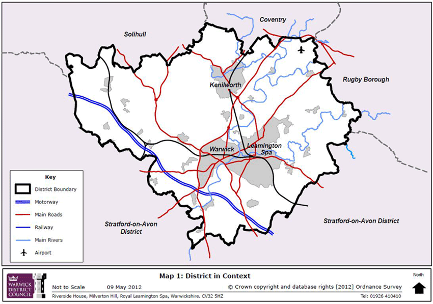
1.9 The District lies between the City of Coventry and rural parts of Solihull to the north, Stratford-on-Avon District to the south and Rugby Borough to the east. It has good transport links by rail to Birmingham and London and the M40 provides a good link to London and the south east as well as to the West Midland conurbation. These transport links mean that although located within the West Midlands, the District has some characteristics similar to the south east.
1.10 Warwick District has a growing, ageing, ethnically diverse and highly skilled population. 90% of the 137,700 residents (2011 Census) live in the main urban areas of Kenilworth, Warwick, Whitnash and Royal Leamington Spa with the remaining 10% living in a number of relatively small villages. The population has grown from 124,000 in 2000 — an 11% increase — and is forecast to continue to grow, with potentially a 17% growth over the next 15 years.
1.11 Compared to other parts of Warwickshire, a higher proportion of the District’s population is of working age. The highest rate of projected population growth in the future is expected to be amongst those aged 65 and over.
1.12 The District has a diverse population, with a high proportion of non-white British residents (15% of the total population) compared to other Districts in the County.
1.13 Relative to the West Midlands as a whole, the District has a strong local economy, with a skilled population and higher than average levels of productivity and earnings compared with regional and national averages.
1.14 The vast majority of the District’s rural area within the West Midlands Green Belt, with only the area to the south of Warwick, Whitnash and Royal Leamington Spa lying outside the Green Belt.
1.15 A significant proportion of the District is designated for its environmental or historic value. To protect and maintain the character of the District, the Local Plan will have to balance the growth of the District with the protection and enhancement of these assets.
1.16 Areas of historic or environmental importance in the District include:
7 Sites of Special Scientific Interest
15 Sites of Importance for Nature Conservation
2145 Listed Buildings
29 Conservation Areas (covering 4% of the District)
11 Registered Parks and Gardens (covering 4% of the District)
1.17 The District’s relative prosperity masks some significant areas of deprivation. In particular, Lillington lies within the most deprived 20% of Super Output Areas nationally. Further, the changing needs of business means that some of the District’s traditional industrial areas require regeneration, with many of these areas located alongside the Grand Union Canal in Warwick and Royal Leamington Spa. The District’s 40km of canal offer particular opportunities for recreation, regeneration and environmental improvement.
1.18 The three main town centres of Royal Leamington Spa, Kenilworth and Warwick provide a focus for retail, leisure and employment. The unique and high quality environments of these town centres has meant that they have been relatively resilient to the recent recession and the competition from online retailing and other retail areas and town centres. Despite this there has been an increase in vacancy rates and a fall in rents in some of parts of the town centres indicating a need to continue to focus investment in these areas.
(10) Duty to Cooperate and Strategic Planning
1.19 The West Midlands Regional Spatial Strategy (WMRSS) was revoked in May 2013. Previously this provided the context for planning for growth in the District by indicating levels of growth required (in relation to housing, retail and employment) and how the spatial distribution of the District’s growth aligned with growth elsewhere in the region and sub-region.
1.20 Whilst the WMRSS is no longer extant, the Council has continued to recognise the importance of working on strategic issues across boundaries. Warwick District is not an island and therefore proposals and policies elsewhere impact on the District and vice versa. For this reason, the Council has worked cooperatively with a range of organisations in the region and sub-region on cross boundary, strategic issues. Specifically, the Council has cooperated with other organisations in relation to the following issues:
1.21 Housing requirements: the Council has undertaken a Strategic Housing Market Assessment for the Coventry and Warwickshire along with the other 5 local planning authorities within the sub- region. This has provided a sub-regional evidence base on the quantum of housing required in Coventry and Warwickshire. This evidence base has been used as a starting point for on-going discussions about the quantum of housing to be delivered in each district. These discussions have been undertaken through the Coventry, Solihull and Warwickshire Planning Officers group (CSWAPO) and its associated Duty to Cooperate Sub Group and within the Coventry and Warwickshire Joint Committee (Members Group). This has ensured that the strategic issues relating to the level and distribution of housing growth have been shared across the sub region and are supported by a sound and shared evidence base.
1.22 Each of the authorities within the sub region is at a different stage in preparing their local plan or core strategy. The capacity of the other districts to deliver their housing requirement in full is therefore not known. In this context, the potential remains that one or more of these authorities will not be able to meet their housing requirement within their boundaries. Warwick District Council has therefore been working closely with the other authorities in Coventry and Warwickshire to agree a robust process to address this issue should it arise. This process has been agreed by the Coventry and Warwickshire Joint Committee. It involves three broad stages:
ensuring a robust and up to date joint evidence base;
agreeing a sub-regional strategy for meeting any shortfall in housing provision; and
reviewing Local Plans where necessary.
1.23 If required, the Council is committed to an early review of its Local Plan to address any shortfall in the sub region’s housing provision.
1.24 The Council and along with the other Councils in the Coventry and Warwickshire sub-region have also cooperated with Councils in neighbouring housing market areas, particularly the Birmingham area. Whilst it is not anticipated that Warwick District Council will be approached directly to accommodate any housing shortfall from the Greater Birmingham area, there is a possibility that other Councils within the Coventry and Warwickshire sub-region will be. This could have knock on effects for the District. It has therefore been agreed, that any housing shortfall arising from within the Greater Birmingham area will also be addressed using the approach described above.
1.25 Employment Requirements and the Coventry and Warwickshire Local Enterprise Partnership: the Council has worked through the Coventry and Warwickshire Local Enterprise Partnership to cooperate in the preparation of a Strategic Employment Land Review which looks at the requirements for employment land across the Coventry and Warwickshire sub-region including the need for a site/sites of sub-regional significance which are of sufficient scale to attract international and national investors. Alongside this, the Council has also actively participated in a review of major employment sites of sub-regional scale. This information has fed into the preparation of the Strategic Economic Plan (SEP) for the sub-region, including the identification of strategically important employment sites for the future.
1.26 The Council has participated in the City Deal for Coventry and Warwickshire. This has identified key employment sectors on which the sub-region can focus on for inward investment, with Advanced Manufacturing and Engineering being particularly important. The outcomes of this process have included the identification of the former Honiley Airfield (a site within Warwick District) as an important investment site which has the potential to be unlocked through improved infrastructure.
1.27 The Council continues to be actively engaged with the Local Enterprise Partnership on an on-going basis.
1.28 Other Strategic Issues: The Council has also actively cooperated with neighbouring Councils in relation to other strategic issues including:
Green Infrastructure: recognising that green infrastructure crosses administrative boundaries, the authorities in the Coventry and Warwickshire Sub-region have developed a sub-regional Green Infrastructure Strategy which has informed the development this Plan. This Strategy has included mechanisms to introduce biodiversity offsetting.
Planning for and delivery of transport infrastructure: whilst planning for, and providing, transport infrastructure is the responsibility of Warwickshire County Council, the Council has actively participated in work to plan for this sub-regionally, particularly in preparing the Strategic Economic Plan.
Green Belt: the Council participated in the Joint Green Belt Study in 2009 and is committed to involvement in a review of this.
(6) Plan Period
The period covered by the Local Plan is 2011 to 2029. As far as possible, the evidence base and future projections are based on 2011 data and project forward until at least 2029
(4) Issues
1.30 The District faces a number of opportunities and issues and it is important that the local plan addresses these.
The legacy of the recent recession on the economy and opportunities for economic growth provided by the District’s economic diversity and in particular by the Advanced Manufacturing and Engineering Sector.
Relatively high house prices limiting the ability of local people to buy or rent property in the area, creating the need for more affordable housing for families in towns and villages and the need to provide more housing to meet future needs, particularly those of older people.
The threat to the economic strength of the town centres of Warwick, Royal Leamington Spa and Kenilworth as a result of the recent recession, online and developments elsewhere. This is balanced by the opportunities provided by the high quality and unique environment of the three main town centres.
The size and condition of existing community facilities and services (particularly schools and health-care facilities) and the challenge involved in enabling these to meet current and future needs.
People’s general health and well-being, and the need for people (particularly teenagers and young people) to have access to sport and cultural experiences, such as cinemas and community events.
Road congestion and air pollution, particularly around the main junctions along the A46 and M40, the routes into the towns, and within the town centres.
The threat of flooding of homes and businesses in some areas, particularly where surface water may flood towns and villages, and the concern that the threat of flooding will increase because of climate change.
Areas of deprivation in Warwick and Royal Leamington Spa.
The pressure for new development and climate change threatening the high-quality built and natural environments in the District, particularly historic areas, and the cost of maintaining historic buildings and areas.
Opportunities to attract investment (housing, business and infrastructure) in to the District as a result of its high quality environment and good links and communication.
Crime and the fear of crime, particularly in town centres, and the need to protect the community from harm.
The Government’s planned High Speed 2 rail line and its possible effects on the area.
Consultation and Evidence
The preparation of this Plan began in 2010 following a Council resolution on 29th September 2010 not to proceed with preparing and adopting the draft Core Strategy that was in preparation at that time. This was in response to the Localism Act and in particular to the Secretary of State’s announcement that Regional Strategies would be revoked. This provided a significant change to the context of plan preparation in Warwick District.
This Local Plan has evolved in the years since 2010 taking account of four consultations and updated evidence.
(48) Consultation
1.33 Issues, Growth Scenarios and Draft Objectives Consultation, May/June/July 2011: this consultation was undertaken to seek representations relating to three broad areas:
issues for the Plan;
growth scenarios, relating to three levels of growth; and
Local Plan objectives.
1.34 Preferred Options Consultation, June and July 2012: this consultation sought representations regarding:
The Local Plan Vision
Local Plan objectives
Preferred Level of Growth
Distribution of growth including proposed sites for housing and employment
The direction of Local Policies
1.35 Revised Development Strategy Consultation, June and July 2013: this consultation focused on the Development Strategy of the Local Plan putting forward revised proposals regarding the level of growth and the preferred sites for housing and employment. It also provided additional information on the transport infrastructure needed to support the strategy.
1.36 Village Sites and Rural Settlement Boundaries Consultation, December 2013 and January 2014: this consultation sought representations on housing sites in and around villages and on rural settlement boundaries – including the new Green Belt boundaries for the growth villages.
1.37 The points emerging from these consultations are described in the Reports of Public Consultation
(7) Evidence
1.38 The full evidence underpinning this Plan’s policies and proposals are set out on the Council’s website. The evidence base includes the following:
Sustainability Appraisal
Strategic Transport Assessments
Employment Land Reviews
Retail and Leisure Study
Joint Strategic Housing Market Assessment and other housing requirement studies
Strategic Housing Land Availability Assessment
Site Selection Methodology
Affordable Housing Viability Assessment
Gypsy and Travellers Accommodation Needs Assessment
Village Settlement Hierarchy Report
Joint Green Belt and partial Green Belt Review
Green Infrastructure Study and Delivery Assessment
Parks and Open Spaces Audit
Sports Pitches and Indoor Sports Facilities Study
Setting of Heritage Assets studies
Habitat Regulations Appropriate Assessment – Screening Report
Habitat Biodiversity Audit
Climate Change Adaptation Study
Air Quality Assessment
Water Cycle Study
Strategic Flood Risk Assessment
Vision, Strategy and Objectives
(8) Vision for the District
1.39 The Council’s vision for Warwick District (which we share with our partners), as set out in the Sustainable Community Strategy, is “to make Warwick District a Great Place to Live, Work and Visit”.
1.40 The Council and its partners are trying to deliver this vision together through the Sustainable Community Strategy. This sets out the approach to address 5 key priorities:
Safer Communities
Health and Wellbeing
Housing
Prosperity
Sustainability
1.41 The Sustainable Community Strategy is central to improving the quality of life in the District across all these priorities. The Local Plan is a key element in the delivery of the Sustainable Community Strategy. The Local Plan has therefore been aligned with the Strategy to ensure it addresses the key priorities.
(10) Local Plan Strategy
1.42 This Plan aligns with the Warwick District Sustainable Community Strategy by focusing on the following strategic priorities:
Supporting Prosperity: seeking to enable the District’s economy to prosper by providing opportunities for businesses to grow and relocate is an important priority for the Local Plan. To achieve this, the Plan sets out policies and proposals to support employment, vibrant town centres and a strong cultural and tourism offer.
Providing the homes the District needs: providing opportunities to deliver the housing needed to support the District’s changing and growing population is central to the Plan, ensuring this is high quality and affordable, at the same time as meeting the needs of everyone including those with specialist housing needs.
Supporting sustainable communities (including health and wellbeing and community safety): there are many aspects to the delivery of sustainable communities including the design and layout of new development; provision of infrastructure; spaces and services to enable healthy and safe lifestyles; regeneration and enhancement of existing communities and environments and the protection of the natural and built environment.
1.43 In this Plan, these strategic priorities, are supported by a Spatial Strategy which seeks to:
maximise use of brownfield sites;
only bring forward greenfield sites in sustainable locations;
avoid coalescence between settlements;
protect important heritage assets;
protect areas of high landscape value and important natural assets;
focus employment, retail, leisure and cultural activities in town centres; and
only develop sites in the Green Belt where exceptional circumstances can be justified.
1.44 The Plan’s objectives link the Local Plan strategy, with the specific proposals set out in the following Local Plan Chapters. The objectives provide the framework to deliver sustainable development by balancing social, economic and environmental imperatives and where possible enhancing all three.
(9) Objective 1: Providing sustainable levels of growth in the District.
1.45 Provide a sustainable level of economic growth (and balance this with housing growth) to maintain high levels of employment, and to deal with pockets of unemployment in deprived areas. This Plan will:
identify and maintain a flexible and varied supply of accommodation and land for business that is the right type and in the right location;
support the growth of advanced manufacturing and engineering businesses, knowledge industries, energy industries and the rural economy; and
improve the rates of business growth in the District to support the ‘organic’ growth of the local economy.
1.46 Provide a sustainable level of housing growth (and balance this with economic growth) to reduce the number of people who are currently homeless or living in unsatisfactory accommodation , to meet future housing needs, and to help deal with the issues of need for affordable housing. The Local Plan will:
identify and maintain supply of land for housing to meet the objectively assessed needs for market and affordable housing ensuring this is of the right size, has the right tenure, and is in the right location;
make sure that the district can accommodate university students without harming the balance of existing communities;
allow providers to meet the special housing needs of the growing number of older people; and
make provision for gypsies and travellers in order to deal with local need and historic demand.
1.47 Provide a sustainable level of retail and leisure growth that will meet people’s existing and future needs, and will maintain and improve the vitality and viability of existing town and local centres as attractive and safe places to visit both by day and night. The Local Pan will:
plan for their future management and growth of each town centre, taking account of their unique roles, to provide sustainable levels of retail and leisure growth.
(5) Objective 2: Providing well-designed new developments that are in the right location and address climate change
1.48 Make sure that new developments are in places that will reduce the need for people to use their cars. This will minimise air pollution and help address climate change by reducing road congestion and carbon emissions, and will encourage people to live more healthy lifestyles by walking and cycling more.
1.49 Encourage new developments to be designed and built so they use water and energy efficiently and reduce the overall demand for natural resources (specifically by increasing the use of renewable and low-carbon sources of energy to reduce carbon emissions).
1.50 Make sure that new developments are located, designed and built so that they can deal with the expected effects of climate change, particularly flooding.
1.51 Make sure new developments are appropriately distributed across the District and designed and located to maintain and improve the quality of the built and natural environments, particularly historic areas and buildings, sensitive wildlife habitats and areas of high landscape value. In addition new developments should respect the integrity of existing settlements.
1.52 Make sure new developments are built to a high standard in terms of design, and provide inclusive, lively and attractive places where people feel safe and want to live, work or visit.
1.53 Make sure new developments provide public and private open spaces where there is a choice of areas of shade, shelter and recreation which will benefit people and wildlife and provide flood storage and carbon management.
1.54 Protect and enhance high quality landscapes and important heritage and natural assets, ensuring that where adaptation is needed, this is done in a sensitive way.
(4) Objective 3: Enabling the District’s infrastructure to improve and support growth
1.55 Enable improvements to infrastructure, such as schools and the health services, to provide and maintain facilities and services people need, in locations people can get to and which support sustainable economic growth in deprived areas.
1.56 Enable energy, communications, water and waste organisations to improve their infrastructure and services so that they can meet people’s current and future needs, protect the environment, and contribute towards dealing with the causes and mitigating the effects of climate change.
1.57 Enable transport providers to provide improvements, particularly better and more integrated public transport, cycling and pedestrian facilities, to meet people’s current and future needs, improve the safety and efficiency of the transport network, and support sustainable economic growth.
1.58 Enable improvements to be made to the built and natural environments which will help to maintain and improve historic assets, improve habitats and their connectivity, help the public access and enjoy open spaces such as parks and allotments and support healthy lifestyles. Reduce the risk of flooding, keeping the effects of climate change (including the effects on habitats and wildlife) to a minimum,.
1.59 Enable the maintenance and improvement of the quality of sporting and leisure facilities, including opportunities for culture and tourism. This will include maintaining a flexible supply of land and buildings for sport and recreation that is the right quality and in the right location, and can meet people’s current and future needs and support healthy lifestyles.