Village Housing Options and Settlement Boundaries
(4) 7. Village Plans and Housing Options
1 |
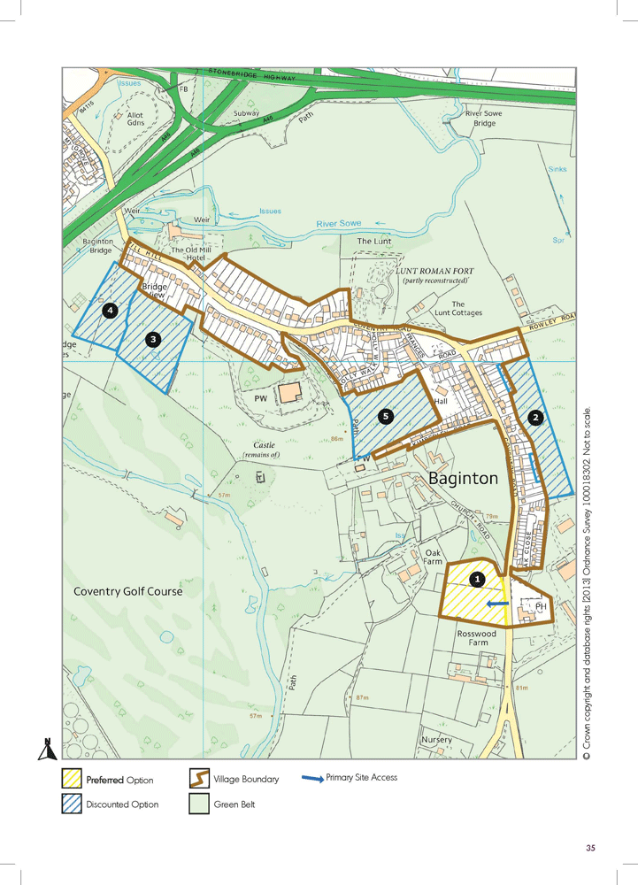
(3) Baginton |
Background Information |
This Green Belt village is situated about 1.7 miles from the south of Coventry, and consists of 356 dwellings and a resident population of 755. Baginton has a good range of services and facilities including a village shop/post office, village hall and public house. The settlement also has a fairly frequent bus service to Coventry. |
Demographic and Household Headlines |
The statistical data-set used for Baginton includes parts of the Stoneleigh and Ashow area and is significantly distorted by the University of Warwick student population bias. Further work is required on extracting data for the village area. |
Key Housing Issues |
The Parish Council has been proactive in identifying a need for more affordable housing. The 2008 Local Housing Needs Survey indicates a requirement for 17 homes (rent x12, shared ownership x5). If the trends are similar to other village locations, this may support a requirement for more affordable smaller family units and housing for people looking to downsize from larger units. The Parish Council is keen to see housing integrated within the current built up areas, rather than dispersed in other locations. |
(5) Sites Review |
The village is constrained by the nearby airport and a number of important historic assets. It also has a significant number of landfill sites. A long list of 8 sites has been reduced to 1 Preferred Option and 3 discounted options. Site contamination and flooding have been two major factors in the discounting of site options. Recently discounted options include 2) land east of Andrews Close – substantial environmental restrictions, 3) Land off Friends Close for similar reasons and 4) land associated with Russells Garden Centre due to major flooding constraints. Land at Mill Hill (5) has been subject to a recent planning application refusal for a new school due to site contamination concerns. |
(1) Preferred Option(s) |
The Preferred Option is:
The site will require a high level of environmental screening but would help reinforce or clearly define the entrance to the village. The site has a developable area of 1.22 ha and capacity for 35 dwellings. Detailed site assessment information is included in Appendix 6 to this report. |
(3) Indicative Settlement Boundary |
The plan also outlines an indicative new settlement boundary for insetting Baginton village within the Green Belt. In this Green Belt village there are important considerations which need to be addressed about whether the conservation area of the village is excluded in part from the inset area, and whether the boundary should be taken to the edge of long gardens or just beyond the building edge. Early comments and views are welcomed on these issues ahead of further detailed discussions with the Parish Council and other bodies. |
2 |
(6) Barford |
Background Information |
This non-Green Belt village is situated about 3.5 miles from the south of Warwick, and consists of 606 dwellings and a resident population of 1336. Barford has a good range of services and facilities including a village shop/post office, community centre, primary school, nursery and public houses. It also has a fairly frequent bus service with connections to Warwick. |
Demographic and Household Headlines |
In line with other more rural locations, Barford has witnessed a decline in the number of 0-15 year olds (-9.8%) from 2001 to 2011. The most significant % growth has taken place in the over 75’s (up by 34 people from 112 to 146 people (30.4% ). The single biggest increase in absolute numbers by age group is within the 60-74 year old - up by 50 people or 17.6%. From 2001 to 2011 the area has witnessed its highest growth in professional occupational classes. The area has a high proportion of detached property compared to the district average (48.4% compared to 24.3%). |
Key Housing Issues |
Discussions with the Joint Parish Council (JPC) have indicated some support for a limited range of housing in the village. However there is a focus upon more incremental growth linked to perceived local housing requirements. These include housing for over 55’s and more affordable smaller family houses. The village is also subject to a number of planning applications on small and medium scale housing sites, including land near Barford House. The last adopted local housing need survey (2008) indicated a need for 11 homes (rent x10, shared ownership x1). |
(7) Sites Review |
The JPC has worked fairly closely with WDC on housing site discussions and option development. This started with a long list of about 13 options for the settlement, which has been reduced down to 3 preferred options and 4 recently discounted options. The early discounted options included a number of sites around the historic core of the village settlement, including near Barford House and land near the church, plus some difficult to access sites between the main settlement and the Barford Bypass. Recently discounted options include: 4) land off Wasperton Road – high landscape impact, 5) land north of the telephone exchange – access problems and site flooding, 6) land south of Barford House – landscape impact and 7) land to the south of Westham Lane – site access concerns. In light of landscape and habitat assessment work, the land between the bypass and the village became the real focus for selecting lower impact housing options. A recently approved outline application for a small number of dwellings south of Westham Lane was not included in the options development. |
(3) Preferred Option (s) |
The three selected Preferred Options are:
Detailed site assessment information is included in Appendix 6 to this report. |
(8) Indicative Settlement Boundary |
The plan also outlines an indicative new settlement boundary for Barford village. The village boundary is extended westwards to include the preferred housing options. It should be noted that Barford Parish Council is currently in the early stages of producing a Neighbourhood Plan for the Parish, and it may be the case that final decisions on the settlement boundary are agreed jointly with the Parish Council. |

3 |
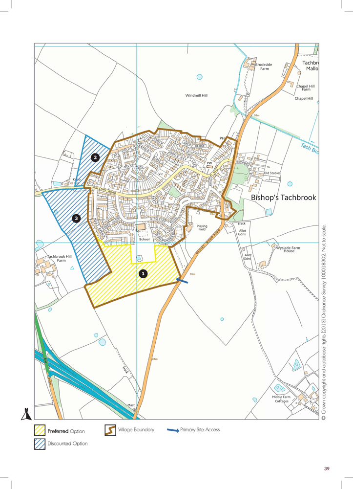
(6) Bishop’s Tachbrook |
Background Information |
This non Green Belt village is situated about 3.3 miles from the south of Leamington Spa, and consists of about 737 dwellings and a resident population of 1700. Bishop’s Tachbrook has a good range of services and facilities, including a village store, church, sports and social club, public house and primary school. The village has a broadly hourly bus service to Leamington Spa. |
Demographic and Household Headlines |
In line with other more rural locations, Bishop’s Tachbrook has witnessed a decline in the number of 0-15 year olds down from 248 to 217 (31) in absolute terms (-12.5%) from 2001 to 2011. The most significant percentage growth has taken place in the over 75’s (up by 16 people from 92 to 108 people (17.4% ). From 2001 to 2011 the area has witnessed a slight growth in people from professional, associate professional / technical, administrative occupations and sale, customer service occupational backgrounds. The area has a higher than district percentage of owner occupied property (73% compared to 66.6%). There is also a bias in the housing stock with 57.1% of the stock semi-detached compared to 30.9% for the district. It also has lower levels of detached properties. |
Key Housing Issues |
The Parish Council is actively involved in developing a Neighbourhood Plan for the Parish. Some key local housing issues include tackling some of the distortions in the village housing stock and ensuring that any new development is well integrated into a comprehensive vision for the village. This may include a focus around regenerating or enhancing facilities near the sports ground and providing a better access to the primary school. The local housing needs study from 2009 indicated a need for 14 homes (rent x9, shared ownership x1, owner x4). |
(9) Sites Review |
There continues to be considerable interest from developers in housing options around Bishop’s Tachbrook. A long list of 15 sites with 12 historically discounted, mainly due to scale, landscape impact and coalescence issues. Of the 3 remaining, 1 site has been selected as the Preferred Option due to its potential regenerative impact on the village and potential improvements for accessing the primary school. The recently discounted sites are: 2) land west of Bishop’s Tachbrook – edge of settlement site sited some distance from local services and 3) land at Tachbrook Hill Farm – larger scale site with lower regenerative benefits than the preferred option. |
(4) Preferred Option(s) |
The Preferred Option is:
This is a reasonable large site (approximately 5.7 ha developable area) and with a revised capacity of 150, subject to suitable environmental screening and a new access road. The site would need to be delivered through a phased strategy and requires detailed master planning to enhance connectivity to nearby land uses. Detailed site assessment information is included in Appendix 6 to this report. |
(7) Indicative Settlement Boundary |
The plan also outlines an indicative new settlement boundary for Bishop’s Tachbrook village. The village boundary is extended southwards to include the preferred housing option site. It should be noted that further discussions will be required with the Parish Council and other bodies, including the Neighbourhood Plan Working Group about the extent of the settlement boundary. |
4 |
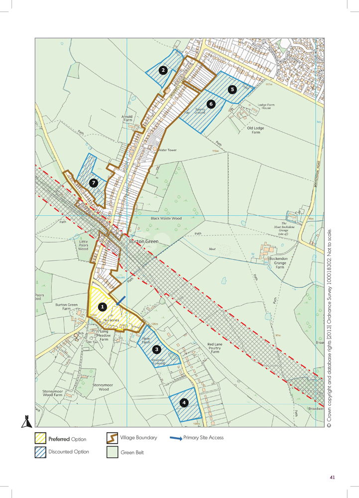
(29) Burton Green |
Background Information |
This Green Belt village is on the edge of Coventry and approximately 3.2 miles to Balsall Common. It consists of about 263 dwellings and a resident population of 643. Burton Green has good public transport connectivity including being within 0.4 miles of Tile Hill Railway Station. The village has a primary school, village hall, two nurseries and a public house. |
Demographic and Household Headlines |
Burton Green has witnessed a decline in 0-15 year olds in line with many other village locations from 2001 to 2011, down from 287 to 250 (-37 in absolute terms or -12.9% change). The village has also seen a reasonable drop in 30-44 year old and 45-59 year olds (-17.1% and -11.3% respectively). From 2001 to 2011 the number of 60-74 year olds has increased by 87 to 335 from 248 (35.1% increase). The village also has very high levels of owner occupation (89.2%) compared to the District average (66.6%). It also has higher than district numbers of detached properties (46.8%) compared to 24.3% for the District. The village has also witnessed a 9.8% increase in people from professional occupations from 2001 to 2011. |
Key Housing Issues |
The Parish Council is at the early stage in the development of a Neighbourhood Plan for the parish and key local housing issues tend to focus around the potential loss of housing through the HS2 rail line, which goes through the centre of the village. A very recent local housing needs survey ( June 2013) has identified a need for 9 homes (rent x 1 2 bed house, owner occupier 1 x 2 bed bungalow, 2 x 2 bed house, 2 x 3 bed bungalow, 3 x 3 bed house). The Parish Council is also keen that housing development is used to support the future regeneration of the village through the creation of a new village centre, subject to HS2. The majority of the settlement is currently structured around ribbon and roadside developments with long gardens. |
(38) Sites Review |
There has been considerable interest from developers and landowners in presenting possible housing options in the Burton Green area. 16 options have been reduced down to 6 recently discounted options and 1 preferred option. Recently discounted options include: 2) land to the rear of the Peeping Tom Pub – poor access and out of character with surrounding area; 3) Red Lane to the south of New Farm – significant landscape impact and potential ribbon development; 4) land North of the Small Holding, Red Lane – significant impact on landscape character; 5) Land SW of Westwood Heath Road – elevated location with high landscape impact; 6) Land off Cromwell Lane – limited site access and high landscape impact; 7) Land off Hodgetts Lane – concerns over deliverability – access needs to be resolved. A number of the sites have significant landscape impact and would encourage a major expansion of ribbon development – particularly along Red Lane. |
(9) Preferred Option(s) |
The Preferred Option is:
This is a medium sized village site (approximately 2.51 ha developable area) and with a capacity of 75 dwellings, subject to detailed layout considerations. The site has the benefit of helping better connect the village (including the primary school) and providing the opportunity to potentially relocate the village hall and create a new village green. Detailed site assessment information is included in Appendix 6 to this report. |
(18) Indicative Settlement Boundary |
The plan also outlines an indicative new settlement boundary for insetting Burton Green village within the Green Belt. In this Green Belt village there are important considerations which need to be addressed about how ‘tight’ to draw the inset boundary - whether the boundary should be taken to the edge of long gardens or just beyond the building edge. Early comments and views are welcomed on these issues ahead of further detailed discussions with the Parish Council, Neighbourhood Plan Working Group and other bodies. |
5 |
(11) Cubbington |
Background Information |
This settlement is located about 1.6 miles to the east of Leamington Spa and is bounded by Green Belt. It is well connected by public transport with bus connections generally every 13-17 minutes with a population of about 2183 and 980 dwellings, the village is well serviced with community facilities and has a village shop, post-office, two primary schools, public houses, early years nursery and place of worship. |
Demographic and Household Headlines |
Statistical information for Cubbington East (Lower Level Super Output Area) indicates that the area has witnessed a reasonably high reduction in the number of 0-15 year olds from 2001 to 2011 by -30.8% (change from 263 to 182 or -81 in absolute terms). The number of people aged 60-74 has increased slightly but the number of 75 and over has increased by 27.4% (of from 186 to 237 – 51 in absolute terms). The settlement has a higher than district average number of owner occupied tenures – 79.6% compared to 66.6% for the district. It has also witnessed a slight growth in people from professional occupational groups from 2001 to 2011. The village has a significantly higher number of semi-detached properties compared to the district average (53% contracting to 36.8%). |
Key Housing Issues |
The Parish Council has taken a proactive approach to tackling local housing issues and is supporting a new affordable housing project. There is a recognition that the Parish needs to consider planning for growth to support retaining local residents and attract new people to move into the area to support local services / facilities and businesses. A local housing needs survey was completed in Nov. 2009 - 6 homes which identified a need for (rent x5, shared ownership x1). The PC is keen that any housing options help enhance the local area and need to avoid overdevelopment and coalescence of settlements. |
(8) Sites Review |
11 options have been identified in the Cubbington area of these 5 were discounted mainly due to high landscape / Green Belt impact, concerns about coalescence, flooding impact and in one case separation from the settlement. Of the remaining 6 options, 2 have been taken forward as Preferred Options. The recently discounted options include: 3) Allotment Gardens, Coventry Road – insufficient vehicle access / landscape impact; 4) Waverley Equestrian Centre – insufficient vehicle access / landscape impact; 5) land north of Bungalow Farm – poor access and elevated site; 6) not detailed – confidential option. The Green Belt and landscape around Cubbington scores high for function quality and this has restricted a number of potential development options. |
(2) Preferred Option(s) |
The Preferred Options are:
A masterplan will be required demonstrating connection between the sites, potential small scale regeneration links to nearby commercial properties and the enhancement of the road frontage along Rugby Road. Detailed site assessment information is included in Appendix 6 to this report. |
(4) Indicative Settlement Boundary |
The plan also outlines an extension of Cubbington’s current built form and the removal of a parcel of land out of the Green Belt to enable this development to proceed. |

6 |
(270) Hampton Magna |
Background Information |
This Green Belt village is located about 2.3 miles to the west of Warwick and has good public transport connections including a regular bus service and is within close proximity to Warwick Parkway Railway Station. It has about 632 dwellings and a population of about 1431. The village also has a good range of community facilities and services including a village shop and post-office, village hall, public house, doctors’ surgery, early years nursery and primary school. The village is a fairly recent development, built on the site of the former Budbrooke Barracks in the late 1960s and early 1970s. |
Demographic and Household Headlines |
The village falls within a complex area for statistical data research and within the Lower Level Super Output Area for a large parcel of land which also covers Budbrooke Village, Norton Lindsey, Hampton on the Hill and the majority of Hampton Magna. Information from the Census (2001 to 2011) indicates that this area has witnessed a substantial ageing of the population, with a decline in the number of 0 -15 year olds, 16-29 year olds, 30-44 year olds and 45-59 year olds. The highest percentage change is -24.3% in the 30-44 year old grouping and the highest absolute decline number is in the 45-59 year old group with a loss of 116 people. The number of 60-74 year olds has increased by 181 (from 232 to 413) or 78%. Overall the area has remained pretty stable for household tenures and has witnessed a small increase in professional occupancy numbers, but less than the district average. There is a bias in the housing stock towards detached properties - 66.5% of the overall housing stock compared with a district average of 24.3%. |
Key Housing Issues |
Hampton Magna is one of the villages with the strongest opposition to housing development. As with many village settlements there are particular challenges locally about improving the range of housing available to allow people to move and live locally (downsizing from larger properties and younger couples / families looking to purchase starter homes). No local housing needs information is available although the Parish Council has indicated an interest in a new survey being undertaken. The PC is not supportive of development but is keen to see that any housing proposals that are suggested minimise both residential and landscape impact, and where possible are well connected to local facilities and services. The impact of development on traffic and existing infrastructure (sewage / drainage) will need to be carefully considered. |
(52) Sites Review |
8 options have been identified in the Hampton Magna area and 2 of these were discounted historically due to landscape impact on one and deliverability on the other. Of the 6 remaining options 5 have been discounted and 1 Preferred Option has been selected. The discounted options include: 2) land to the east of Clinton Avenue/Gould Road – very visible site with high landscape impact; 3) land north of Montgomery Avenue – insufficient vehicle access; 4) land west of Stanks Farm – disconnected from the main settlement; 5) land south of Lloyd Close – highly visible site with significant impact on residential properties; 6) Maple Lodge – located within a very sensitive landscape area. The site selection attempts to minimise environmental impact in a village surrounded by sensitive landscape and Green Belt issues. |
(4) Preferred Option(s) |
The Preferred Option is:
A comprehensive phased masterplan will be required for this area to integrate the site with the existing settlement and effectively link through to community facilities at the school and nearby areas. A phased development would be encouraged for this area with attention also paid to environmental screening and minimising impact on nearby residential properties. Detailed site assessment information is included in Appendix 6 to this report. |
(124) Indicative Settlement Boundary |
The plan also outlines an indicative new settlement boundary for insetting Hampton Magna Village within the Green Belt. The boundary has been drawn fairly ‘tight’ which is reflective of the settlement’s current build form. Early comments and views are welcomed on these issues ahead of further detailed discussions with the Parish Council, potential Neighbourhood Plan Working Group and other bodies. |

7 |
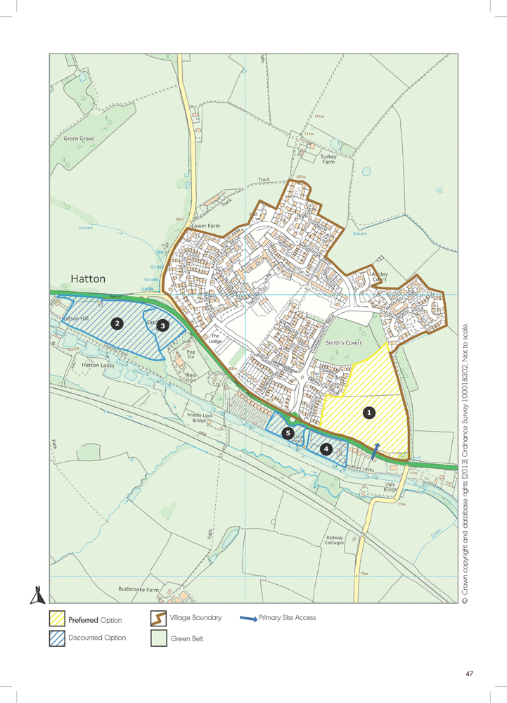
(26) Hatton Park |
Background Information |
This Green Belt village is located about 2.9 miles to the west of Warwick and has good public transport connections including a regular bus service and is within close proximity to Warwick Parkway Railway Station. It has about 798 dwellings and a population of about 2020. The village has a reasonable range of community facilities and services including a village shop and village hall. The village is a fairly recent development built on the site of a former hospital and consists of a diverse range of property styles. The village is a popular commuting location. |
Demographic and Household Headlines |
The village falls within a complex area for statistical data research and within the Lower Level Super Output Area for a large parcel of land which also covers parts of Shrewley Parish and up to Hatton Green. Information from the census (2001 to 2011) indicates that this area has witnessed a growth in population (mainly around the development of this settlement) and has seen a strong growth in 0-15 year olds (up from 399 to 666) and also significant growth in the 30-44, 45-59 and 60-74 age groups. The number of owner occupied properties is still above district average (66.6%) , at 75.9%. The strongest growth in occupation has occurred in the professional grouping. The area also has a bias for detached properties which is at 43.9% - higher than the district average at 24.3%. |
Key Housing Issues |
Hatton Park is a relatively new development and it has a lower level of facilities and services than would be expected for a settlement of this size. It has good transport connections for commuting to a wide range of employment locations. No local housing need information is available at this stage, although the Parish Council has been asked to consider looking at this issue in more detail. In the past there have been concerns about the integration of further housing at Hatton Park, with the existing communities. Some of the infrastructure which supports the current settlement in terms of drainage and sewage may need to be upgraded as part of any new development. There maybe a need to look at additional community facilities as part of any development in this location. |
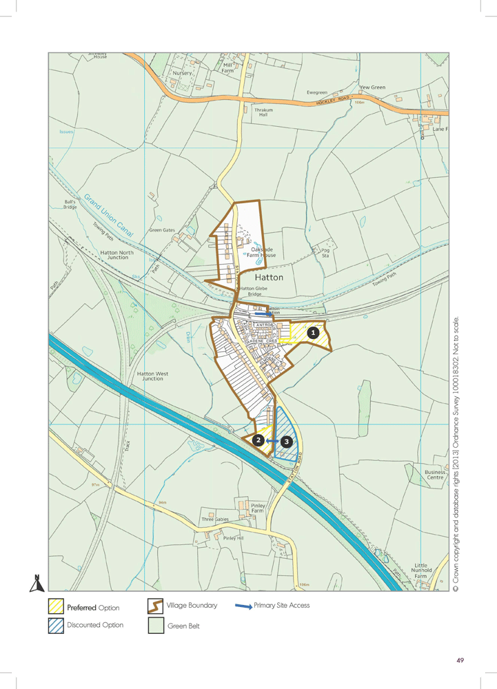
(20) Sites Review |
8 options have been identified in the Hatton Park area and 3 of these were discounted historically due to landscape impacted on one distance from the main settlement and another one withdrawn option. Of the 5 remaining options 4 have been discounted and 1 Preferred Option has been selected. The discounted options include: 2) land north of the Grand Union Canal – very visible site with high landscape impact and separation from the main settlement; 3) land northwest of Severn Trent Treatment Works – significant loss of potential Local Wildlife Site; 4) 407 Birmingham Road and land to the west – impact on potential local wildlife site and wider canal corridor; 5) land west of R75, Birmingham Road – potential impact on Local Wildlife Site and medium / high landscape value. The site selection attempts to minimise landscape impact in an area constrained by landscape and environmental sensitivities around the canal network. |
(12) Preferred Option(s) |
The Preferred Option is:
A comprehensive masterplan will be required for this area to integrate the site with the existing settlement. Attention will also need to be paid to providing sufficient screening from existing residential properties and the area of ancient woodland to the north of the site. Detailed site assessment information is included in Appendix 6 to this report. |
(15) Indicative Settlement Boundary |
The plan also outlines an indicative new settlement boundary for insetting Hatton Park Village within the Green Belt. The boundary has been drawn fairly ‘tight’ which is reflective of the settlement’s current build form. Early comments and views are welcomed on these issues ahead of further detailed discussions with the Parish Council and other bodies. |
8 |
(12) Hatton Station |
Background Information |
This Green Belt village is located about 5 miles to the west of Warwick. Census information indicates about 120 dwellings and a population of 294. The Settlement has an early years nursery nearby and is served by Hatton Park Railway Station. Shrewley Common is located about 1.3 miles from the village and it has a local shop, post office, village hall and public house. The settlement has broadly developed around the Railway Station. |
Demographic and Household Headlines |
The village falls within a complex area for statistical data research and within the Lower Level Super Output Area for a large parcel of land. Further work is on-going on modelling the data-set, but it is anticipated to follow similar broad trends to other village / rural areas. |
Key Housing Issues |
The settlement is well placed to take advantage of its strong position on the railway corridor as commutable to a wide range of locations. However the settlement does suffer from a very limited drainage and sewage system, flooding in parts and close proximity to the motorway network. The Parish Council administers an area with a dispersed range of service and facilities and the integration of a limited range of new housing is part of a strategy to help sustain existing service / facilities, although it is recognised that the settlement does not score highly for settlement sustainability in itself. Recent Parish Plan work has included a focus upon housing issues. |
(11) Sites Review |
5 options have been identified in the Hatton Station area, of these 2 were discounted early in the process due to high landscape impact and some flooding concerns and 3 sites moved forward to more detailed site appraisal (one of these at a fairly late stage in the process). Of these 3 sites, 1 site – west of Station Lane (3) was discounted due to mainly highways access concerns and 2 sites have been suggested as Preferred Options. |
(5) Preferred Option(s) |
The Preferred Options are:
Detailed site assessment information is included in Appendix 6 to this report. |
(52) Indicative Settlement Boundary |
The plan also outlines an indicative new settlement boundary for insetting Hatton Station village within the Green Belt. The boundary has been drawn reasonably wide and there will be discussions required over the size of the boundary, the coverage north of the Railway Station and whether the boundary needs to be drawn closer to residential properties rather than at the end of gardens. Early comments and views are welcomed on these issues ahead of further detailed discussions with the Parish Council and other bodies. |
9 |
(5) Hill Wootton |
Background Information |
This small Green Belt village / hamlet is located about 2.7 miles north of Leamington Spa and 1.1 miles east of Leek Wootton. The settlement does not have any major services and facilities but it is near the major Kenilworth to Leamington transport corridor and just over 1 mile to Leek Wootton, which has a wider range of services / facilities. |
Demographic and Household Headlines |
Due to the size of the settlement, the statistical datasets may give a misleading interpretation of the local area. |
Key Housing Issues |
Leek Wootton Parish Council is at early stages in the development of a Neighbourhood Plan and is keen to explore whether there are very small scale housing options in settlements near Leek Wootton which can assist in reducing some of the housing pressure in the main village settlement but at the same time support local services and facilities. A recent parish wide Local Housing Needs Survey (February 2013) has identified a need for 6 homes (rent - 4 x1 bed flats, 1 x 2 bed house / shared ownership - 1 x 2 bed house). |
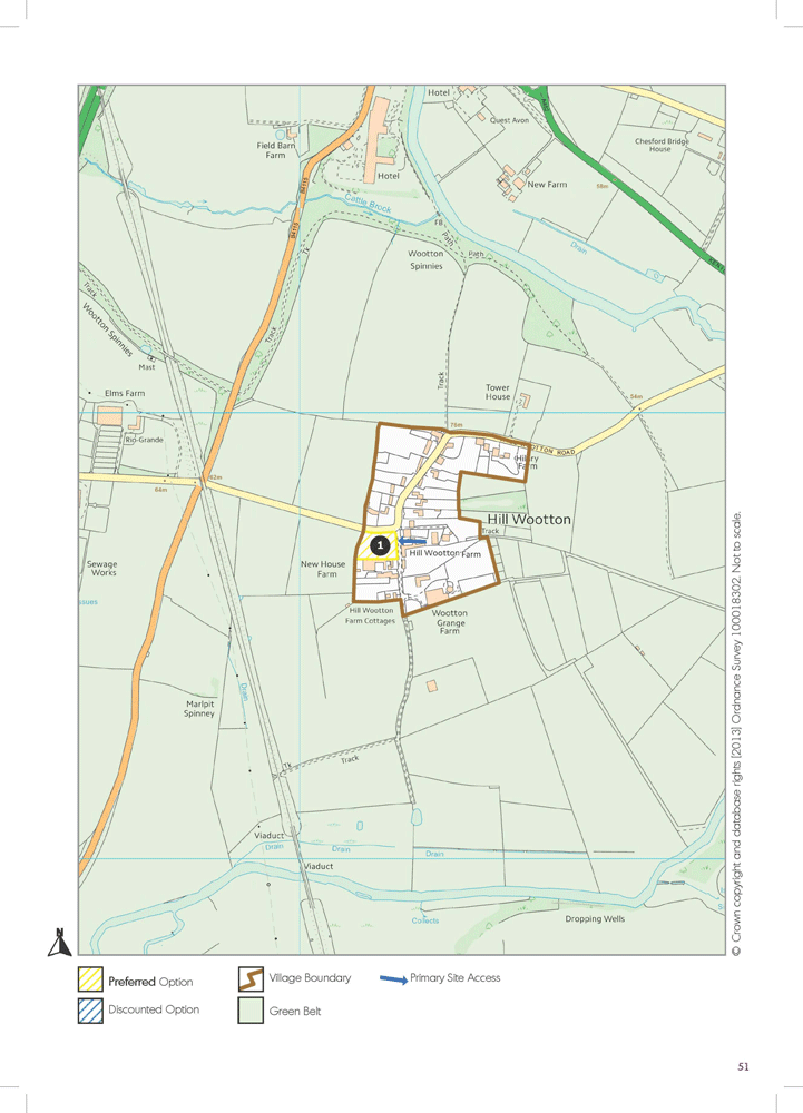
(4) Sites Review |
At a late stage in the site appraisal process one site has been identified as having some housing potential. |
(1) Preferred Option(s) |
The Preferred Option is:
Detailed site assessment information is included in Appendix 6 to this report. |
(8) Indicative Settlement Boundary |
Early comments and views are welcomed on the suggested idea of insetting Hill Wootton in the Green Belt. A suggested indicative settlement boundary is illustrated, ahead of further detailed discussions with the Parish Council and other bodies. |
10 |
(29) Kingswood |
Background Information |
This Green Belt village is located about 4.9 miles from Knowle and towards the west of the District. Census information indicates it consists of 381 dwellings and a population of 842. The village has a good range of services and facilities, including a primary school, early years‘ nursery, village hall, shops and post office, doctors’ surgery, railway station and place of worship. The village has developed incrementally over the years and is constrained physically by the railway and canal corridors. |
Demographic and Household Headlines |
Two Lower Level Super Output Area statistical datasets cover the Kingswood settlement (one north and one south). The settlement is also split between two parish councils – Lapworth and Rowington. Some key headlines for the most northern data-set: substantial growth in 60-74 year olds (up from 189 to 306), from 2001 to 2011. Very high levels of owner occupied homes – 81.8% compared to district average of 66.6%. Biggest occupational growth is in the professional grouping and high levels of detached dwellings compared to the district average (52.6% compared to 24.3%). Data for the southern statistical area shows similar trends but less amplified. |
Key Housing Issues |
There has been reasonably strong opposition to development in Kingswood, with some individuals suggesting a more dispersed strategy to growth across the parish. The village is constrained physically by major railway and canal infrastructure and in terms of housing character contains a fairly eclectic mix of styles and properties, reflective of an incremental approach to housing growth over the years. Both Parish Councils which cover this area have been involved in a number of discussions about housing options. This has partially led to the development of a portfolio of smaller development sites. Research on site access, landscape impact and habitat sensitivity has also restricted development options in this settlement. There are also concerns over flooding in parts of the village and further work will be required on addressing this issue. A local Housing Needs Survey (Lapworth) identified a requirement for 6 homes (rent x4, shared ownership x1, owner x1). Housing requirements and issues are also covered in the recent Parish Plan research for Lapworth. Rowington PC has also been active in discussing housing requirements and option sites with parishioners. |
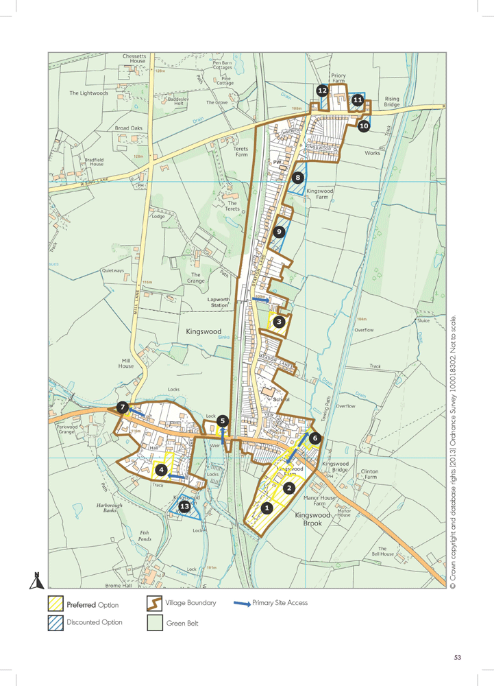
(29) Sites Review |
There has been substantial development interest in Kingswood and 18 development sites have been identified. Of these sites, 5 were discounted at a fairly early stage in the process, due to distance from settlement, loss of facilities and lack of landowner interest in one case. Of the remaining 13 sites, 6 have been discounted and 7 have remained as Preferred Options. The recently discounted sites are:
The Preferred Options selected provide a portfolio of lower impact sites. |
(17) Preferred Option(s) |
The Preferred Options are:
All sites will require a focus upon quality design, site screening and the provision of a suitable mix of housing. Detailed site assessment information is included in Appendix 6 to this report. |
(20) Indicative Settlement Boundary |
The plan also outlines an indicative new settlement boundary for insetting Kingswood Village within the Green Belt. The boundary is quite elongated given the built form of the area. It also includes the railway line. Early comments and views are welcomed on the indicative inset boundary ahead of further detailed discussions with the Parish Council and other bodies. |
11 |
(29) Leek Wootton |
Background Information |
This Green Belt village is located about 2.5 miles to the south of Kenilworth. Census information indicates it consists of 381 dwellings and a population of 915. The village has a good range of service, and facilities, including a primary school, village hall, place of worship and a public house. The village has good accessibility to public transport with buses running broadly hourly and with a 15 minute travel time to Warwick. |
Demographic and Household Headlines |
Statistical information for the area indicates that Leek Wootton has witnessed a drop in 0-15 year olds from 2001 to 2011 of 37 in absolute terms (down from 248 to 211 or -14.9%). During the same period there was also a drop in 30-44 year olds by a similar absolute number. In absolute number terms the biggest growth has been in 60-74 year olds up from 212 in 2001 to 256 in 2011. In line with many other village locations, Leek Wootton has seen a slight increase in people from professional occupational groups from 2001 to 2011. 85.4% of the household tenures are owner occupied which is significantly above the district average of 66.6%. There is also a bias in local housing for detached properties, which make up 65.8% of the local housing stock compared to the district average of 24.3%. |
Key Housing Issues |
The village has been subject to considerable developer interest attracted by the accessibility of the location and desirability of the village. The Parish Council has been keen to highlight the need to minimise the impact of housing locally and was involved in a Local Housing Need survey which indicated the need for 6 homes (rent - 4 x1 bed flats, 1 x 2 bed house / shared ownership - 1 x 2 bed house). As with many other villages, there are particular local housing challenges around older residents looking to downsize and stay locally and more affordable housing. The Parish Council is also at the early stages of a neighbourhood plan and has suggested another location within its administrative area for investigation for limited housing growth. |
(22) Sites Review |
16 sites have been identified in the Leek Wootton village, of these 3 large scale high impact sites were discounted at an early stage in the process, leaving 13 sites for detailed appraisal. Of these remaining sites, 8 have been discounted and 5 have been suggested as Preferred Options. The recently discounted sites are:
The majority of the sites which have come forward as preferred options are perceived to be lower impact sites, which could come forward in a phased manner as part of the regeneration of the former Police HQ site. |
(18) Preferred Option(s) |
The Preferred Options are:
All sites will require a focus upon quality design, site screening and the provision of a suitable mix of housing. Detailed site assessment information is included in Appendix 6 to this report. |
(25) Indicative Settlement Boundary |
The plan also outlines an indicative new settlement boundary for insetting Leek Wootton village within the Green Belt. The boundary covers a significant land mass and decisions will need to be made about how ‘tight’ the boundary is drawn to properties and infill implications for a looser boundary form. Early comments and views are welcomed on the indicative inset boundary ahead of further detailed discussions with the Parish Council and other bodies. |

12 |
(24) Radford Semele |
Background Information |
This non-Green Belt village is located about 2.7 miles to the south of Leamington Spa. Census information indicates it consists of 803 dwellings and a population of 1890. The village has a good range of services and facilities, including a primary school, early years’ nursery, community hall, village shop and post office. The village is also well serviced by public transport with frequent half hourly services to Leamington, taking about 10 minutes. |
Demographic and Household Headlines |
In line with other villages, Radford Semele has witnessed a decline in the number of 0-15 year old from 2001 and 2011 based upon census information (down in numbers from 228 in 2001 to 175 in 2011). The village also witnessed its highest growth in numbers in the 16-29 year old group during the same period (up from 132 to 192). Sharing similar characteristics to other villages the settlement has also witnessed an increase in people with professional occupations. The number of owner occupied household tenures is above the district average (73.7% compared to 66.6%). In terms of housing stock, the village has above district average percentages of semi-detached and terraced housing, and consequently lower levels of detached housing (43.5% of detached compared to district average of 30.9% and 33.9% of terraced properties compared to the district average of 21.5%). |
Key Housing Issues |
No information has been made available from the Parish Council about the level of Local Housing Need or local housing challenges. It is anticipated that the village faces similar issues to some other locations in relation to affordable housing. There may also be particular issues about helping re-balance ‘distortions’ in the housing stock. Similar issues may be shared with Bishop’s Tachbrook, which also has extensive estate developments. In terms of accommodating growth the Parish Council has indicated a need to minimise residential impact and is keen that the settlement maintains its strong physical and community identity. There is a particular sensitivity to avoiding development in areas which may encourage a degree of coalescence between the west of the village and Sydenham. |
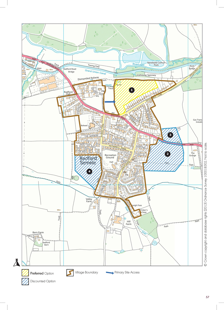
(111) Sites Review |
14 site options have been identified for Radford Semele. Of these initial options, 10 were discounted at an early stage in the process to a wide range of issues detailed in the Council’s Strategic Housing Land Availability Assessment (SHLAA), but include flooding in a number of locations and high landscape impact. Of the remaining 4 options which progressed to a detailed assessment, 3 of these have been discounted and 1 has been suggested as a Preferred Option. The recently discounted options are: 2) Land south of Southam Road – high landscape impact and insufficient vehicle access; 3) Land north of Southam Road - high landscape impact and insufficient vehicle access; 4) South West Radford Semele – impact on main village centre and potential to encourage coalescence of settlements. In line with many other villages there are no easy options in Radford Semele with regard to ideal housing sites. The site selected attempts to strengthen the built form in the area and takes some of the development pressure off the main settlement with its narrow road network. |
(14) Preferred Option(s) |
The Preferred Option is:
A detailed phased masterplan will be required for the site and further detailed work will be required on landscape impact and site access. Detailed site assessment information is included in Appendix 6 to this report. |
(24) Indicative Settlement Boundary |
The plan also outlines an indicative new settlement boundary for Radford Semele Village. This boundary includes land to the north of the settlement around church end. Early comments and views are welcomed on the indicative settlement boundary ahead of further detailed discussions with the Parish Council and other bodies. |
13 |
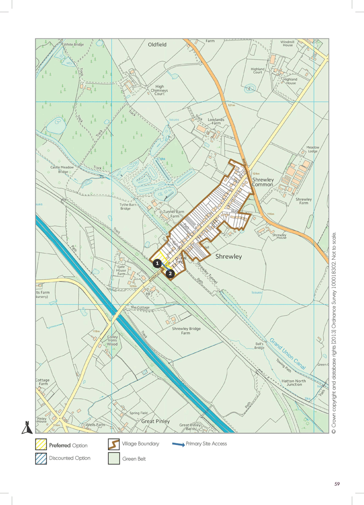
(5) Shrewley Common |
Background Information |
This Green Belt village is located about 5 miles to the west of Warwick. Census information indicates about 115 dwellings and a population of 262. The settlement has a reasonable range of local service / facilities, including a village hall, village shop / post-office and public house. The settlement is very linear in shape, along the main Shrewley Common Road. The Grand Union Canal and also the railway cutting / viaduct are significant local infrastructure features. |
Demographic and Household Headlines |
The village falls within a complex area for statistical data research and within the Lower Level Super Output Area for a large parcel of land. Further work is on-going on modelling the data-set, but it is anticipated to follow similar broad trends to other village / rural areas. |
Key Housing Issues |
The settlement is located near a major railway line and motorway corridor. It plays an important role locally in providing a limited range of village services and facilities, structured mainly around the village hall and local shop. The Parish Council administers an area with a dispersed range of services and facilities and the integration of a limited range of new housing and residents is part of a strategy to help sustain existing services / facilities, although it is recognised that the settlement does not score highly for settlement sustainability in itself. Recent Parish Plan work has included a focus upon housing issues. |
(2) Sites Review |
A limited range of sites have been reviewed for Shrewley Common and this included one historically discounted option, which was not considered suitable due to its separation from the main village and two small housing options which have been assessed as suitable Preferred Options. |
(4) Preferred Option(s) |
The Preferred Options are:
These sites are opposite each other towards the end of the main Shrewley Common Road and provide a natural gateway or finish to the settlement. Detailed site assessment information is included in Appendix 6 to this report. |
(5) Indicative Settlement Boundary |
The plan also outlines an indicative new settlement boundary for insetting Shrewley Common Village within the Green Belt. The boundary has been drawn fairly wide in consideration of the long gardens of many properties in the village. There may be options to draw a ‘tighter’ boundary closer to buildings to restrict options for backland infill development. Early comments and views are welcomed on these issues ahead of further detailed discussions with the Parish Council and other bodies. |
(4) Other Sites
During the consultation with Parish Councils and landowners / developers, two other sites have been identified which technically do have a direct relationship with the villages identified for growth, but may provide opportunities to accommodate housing within close proximity to more urban locations. These are listed for comment during the consultation process.
14 |
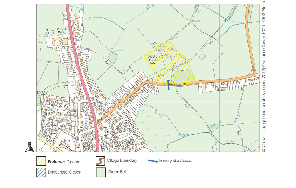
(7) Former Aylesbury House Hotel, near Hockley Heath |
| This Green Belt site is located in Lapworth Parish and consists of a listed building which is currently falling into disrepair and its surrounding grounds. The site is within walking distance of Hockley Heath which has a good range of services and facilities, but is located within Solihull District. The site has a developable area of approximately 3.28 ha and potential to accommodate up to 20 dwellings on site, including the conversion of the listed building. | |
15 |
(5) Oak Lea, Finham |
| This Green Belt site is located within both Baginton and Stoneleigh Parishes. It consists of a large reasonably modern property, outbuildings and grounds. The site forms part of the Finham suburb of Coventry with its associated services and facilities. Located very near the A46, the site has an approximate developable area of 0.67 ha and capacity for 20 dwellings, taking into consideration environmental screening and the development of an appropriate site access. | |
