Village Housing Options and Settlement Boundaries
(3) 5. Site Selection Process and Methodology
5.1 A detailed site selection process and methodology has been developed for appraising village site options. This builds upon the types of information reviewed as part of the Council’s Strategic Housing Land Availability Assessment (SHLAA), but has also included commissioning bespoke research on landscape impact, habitat / species impact and the function and performance of Green Belt and green fields parcels around the villages. Detailed assessments have also been undertaken by professional teams responsible for highways, environmental health and drainage/sewage and potential flooding issues.
(14) Site Selection Process
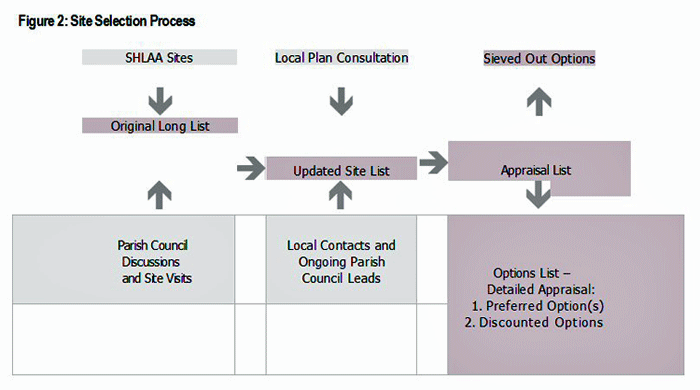
5.2 The selection of potential housing sites has gone through a number of key stages, which are outlined opposite in Figure 2. The first stage of the process involved the establishment of an original ‘long list’ of potential sites, pulling together information from WDC’s SHLAA and supplemented with early site visits and discussions with Parish Councils. Only sites with capacity for 5 dwellings or more have been included in the overall site selection process in line with the SHLAA methodology. The next major stage in the process has involved receiving information about new site options from landowner / developer interests following local Parish Council meetings / discussions and consultation at various stages in the local plan process (Preferred Options and Revised Development Strategy).
5.3 This work then progressed to establishing a revised long list of sites which were first sieved for:
-
sites of excessive size with marginal connection to village settlements;
-
negative SHLAA commentary and obvious impacts / site restrictions;
-
isolated development options with limited connectivity to village settlements, and;
-
sites connected to often smaller less sustainable villages where the Parish Council was not supportive of growth. Following this strategic sieving exercise a fine-tuned list of sites moved forward for detailed appraisal.
5.4 At the pre-sieve stage, WDC was in receipt of 190 site options. This was then reduced to a set of 77 sites for detailed appraisals, resulting in 28 preferred housing options covering 13 village settlements and two additional urban fringe sites, which also came through the appraisal process as potential housing options. The full list of site appraised sites is detailed in Appendix 6.
5.5 For sites undergoing a detailed site appraisal, the key criteria used for assessment is outlined below:
-
An understanding of the physical capacity of the site to accommodate housing at or above 5 dwellings, which is broadly based upon a standard calculation formulae set out in the SHLAA.3 Sites with capacity of less than 5 dwellings have not been included in the site selection process but could come forward as potential housing windfall sites, depending upon their individual circumstances.
-
Any physical site constraints such as layout, site gradient, access, flooding and service infrastructure.
-
The potential impact of the site on areas of heritage or habitat importance, landscape and residential amenity.
-
Key environmental constraints in terms of noise, air and light pollution as well as site contamination.
-
A detailed review of sewage and drainage infrastructure together with site flooding and surface water issues using an in-house specialist team.
-
A partial review of the Green Belt and green field parcels surrounding the villages, with almost 100 individual parcel assessments – this work is summarised in the overall site assessment appendix and is also available as a separate technical appendix (Appendix 7).
-
Key findings from a new technical report on ecology covering habitats and species, which has included new survey work.
-
Key findings from a new report on landscape character and housing sensitivity which has included extensive surveying and primary research.
-
A review of key sustainability appraisal findings.
-
Parish Council feedback – although there is not agreement on all of the sites.
(67) Technical Studies and Research Findings
5.6 The evaluation criteria and content detailed in the site appraisal matrix has been informed by a number of detailed technical studies (see Appendix 6), some of which were specifically commissioned for this report and area of work. WDC is piloting an approach to appraising sites, which builds upon a methodology first initiated in Stratford Upon Avon, through the Ecology and Geological Study of Local Service Villages (39 Villages report) (2010). The more detailed approach undertaken by WDC is also now being taken forward by Nuneaton and Bedworth Borough Council to consider development options around their main settlements. A technical study of the function and role of the Green Belt and also major green field areas around the key growth villages is also an important study. (Appendix 8). The Green Belt appraisal work was also externally appraised as part of a critical review and the key findings to this report are also available as a technical appendix (Appendix 9).
5.7 From the technical studies undertaken there are four strategic headlines, which are worth highlighting.
The Green Belt plays a varied and often important role in preserving the character and setting of many of the District’s villages. One of the first tasks in undertaking the research was to breakdown the overall Green Belt around the villages into defined Green Belt Parcels (often defined by permanent features such as major road, rivers and canal infrastructure). A significant number of the Green Belt parcels are very large in scale and contain often different types of landscapes. While the overall function and role of the Green Belt parcel is a critically important assessment criteria when considering housing options, it was clear that the landscape impact and ecology research would provide a more fine-grained or detailed approach to better understanding areas within the Green Belt which may be less sensitive to change or are better suited to accommodating housing growth.
The technical research has covered both Green Belt and non-Green Belt villages. It was clear from the research that the non-Green Belt villages (Radford Semele, Barford and Bishop’s Tachbrook) had particular environmental, infrastructure and landscape restrictions that limited their options for growth. The research indicates clear environmental limits of developing in non-Green Belt areas. Particular issues include:
-
Radford Semele – high landscape impact scores for land to the east of the village running down to the Fosse way and a major gas pipeline running near the village.
-
Barford – an important historic landscape associated with Barford House which is central to the character of the settlement, the nearby river corridor and open plain with high ecology value and the very open green field parcels to the east of the village.
-
Bishop’s Tachbrook – the importance of the Tach Brook for ecology value and providing a landscape setting to the north of the village.
-
Within a number of the Green Belt villages the research has indicated some substantial environmental and development restrictions which have reduced the ability of several villages to accommodate the level of growth originally indicated at an early stage of the process. Notable examples include:
-
Baginton – a number of contaminated sites, some major flooding issues in one location and potentially significant historic and visual landscape impact in others.
-
Cubbington – very open highly visible Green Belt and landscape parcels, some linked to areas of high ecology value – also access issues on a number of sites.
-
Kingswood – high landscape and ecology values along the canal and river corridor together with site access and flooding issues on a number of sites.
-
These types of considerations have resulted in a substantial reduction in housing numbers for these particular Green Belt settlements.
The Green Belt and landscape assessment work has also emphasised the need to protect villages from coalescence with nearby larger settlements. This was seen as important as it helps maintain the open setting, identity and character of individual settlements. It’s a critical issue in Warwick District which has relatively short distances between many of its villages and large towns and urban areas. On occasions where coalescence may be an issue, a strong approach will be required to define or redefine the village edge and establish a rigorous approach to environmental screening and the design of effective landscaping.
(6) Summary of Findings
5.8 Table 3 attempts to summarise some of the key findings from the technical studies and site evaluation matrix as they relate to individual settlements. It is not a definitive list of findings but provides a brief overview of issues at a village level. Further information is available in the relevant technical studies and appendices to this report.
Table 3: Overview of Findings
| Key Growth Villages | Green Belt / Green Field Function | Landscape and Habitat Impact | Environmental Issues | Site Access and Deliverability | Options and Impact |
|---|---|---|---|---|---|
| Baginton | Generally mixed character Green Belt parcels which play a substantial role in protecting the setting of Baginton Village and providing a green buffer to Coventry. | Historic landscape important with a number of elevated option sites potentially having a significant impact. Pockets of habitat value. | A number of landfill sites with potentially high remediation costs. Flooding, noise issues and odour from the nearby sewage works impacts on a number of sites | Only one site with reasonable vehicle access. | One small site identified on edge of village which may re-define the entrance to the village from the south. Will require substantial environmental screening. |
| Barford | Small lower function parcels to the west of the settlement linked to the bypass. Large open greenfield parcels with strong functionality to the east of the village. | Barford House and gardens plays an important role in the centre of the settlement. An eroded landscape character is obvious in land adjacent to the bypass. | Flooding along river course. Some noise issues associated with the bypass. Development sites will require investment in appropriate sewage / drainage systems. | Site access is difficult to a number of development options in the land between the bypass and village. | Limited portfolio of sites proposed linked to the degraded land between the village and bypass. Focus upon incremental development where possible. |
| Bishop’s Tachbrook | Land between the north of the village and south of Warwick Gates, plays an important role in preserving the setting of the village. | Tach Brook corridor is a strong local landscape and habitat feature. Hedgerows also of key importance in a number of locations. | Potential noise issues associated with sites towards the south of the village (near M40 corridor). | New site access to the south of the village off Oakley Wood Road, will require further detailed analysis. | Generally larger sites, with preferred option for southern extension of the village with regenerative impacts. Phasing will be important. |
| Burton Green | Strategically important areas of Green Belt which maintains the setting and character of Balsall Common, Burton Green and Kenilworth and Coventry. | Pockets of high habitat value linked to ancient woodland and local wildlife sites. Slightly elevated village location with high landscape value for a number of sites. | HS2 restricts the use of a number of sites. High water table in some locations. | Site access is difficult to a number of sites – some are backland areas, and others are within the Red Lane corridor area. | Preferred option focuses upon better connecting the village and creating a new village centre. |
| Cubbington | Number of highly visible open Green Belt parcels, play an important role in preserving the open setting of the village. | Open landscape character a key feature of the village edge. Ancient woodland corridor to the east of the settlement requires protection. | Need to avoid adding to local flooding problems. Appropriate measures required to manage surface water run-off. | Site access is constrained with a number of options. | Preferred option(s) focus upon minimising landscape impact and regenerating a small corner of the settlement edge, subject to suitable site screening and the relocation of existing allotment use. |
| Hampton Magna | Generally large Green Belt parcels which provide a valuable role in maintaining the openness of the landscape and protects the character of Hampton Magna and Hampton on the Hill. | Medium to high landscape value for a number of sites in Hampton Magna. Land to the west of the settlement scores highest. Habitat value mainly associated with field edges and hedgerows. | Development sites will require investment in appropriate sewage / drainage systems. Surface water issues will also need to be effectively managed. | Reasonable site access to a number of sites, but differences in site topography may have an impact on deliverability. | Preferred option minimises environmental impact and provides some connectivity to school. Some potential for enhancement of community facilities. |
| Hatton Park | Mixed character Green Belt parcels dominate the south of the village. Very large parcels preserve the northern boundary of the settlement and links onwards to the A46/ eastern Warwick edge and Leek Wootton. | Strong landscape and habitat values along the canal corridor and adjacent areas of land. | Surface water flooding on Birmingham Road will need to be resolved. | Speed surveys required and further technical work on sites with sub-standard visibility splay. | Preferred option site has lower landscape impact than other sites and would fit with the existing built form. |
| Kingswood | Complex mix of Green Belt parcels which play an important role in maintaining the setting and character of the settlement. Quite small parcels around the core village area – some of degraded quality. | High landscape and habitat values along the canal and brook watercourses. Number of pockets of importance to local wildlife in other locations –particularly towards the south and east of the settlement. | Detailed flood modelling required for the centre of the village to forecast and alleviate localised flooding. Impacts on a number of sites. | Access constrained in a number of option areas. Significant environmental impact to facilitate vehicle access. | Mixed portfolio of smaller site options identified as part of an incremental approach to village development. |
| Leek Wootton | Surrounded by strategically important Green Belt parcels which fulfil a very valuable role in maintaining the open space between settlements to the north and south. | Strong corridor of important habitat sites particularly around the north of the settlement. Historic landscape setting important for Woodcote House. | Surface water flooding may be an issue from elevated sites. | Site access acceptable for a cluster of sites on the Woodcote House Estate. Potential, for site access onto other sites. | Preferred options mainly focus around lower impact opportunities around the Woodcote House Estate. |
| Radford Semele | Surrounded by very large green field or strategically important parcels which play a major role in preserving the setting of the village and also the openness of the landscape from the east of Leamington. | Landscape openness a particularly strong feature towards the east of the settlement. Need to avoid coalescence of Radford Semele and Sydenham to the west. | Substantial flooding issues along The Valley corridor. | Substantial restrictions on site access to the east of Radford Semele. | Preferred option focuses upon land to the north of the village, subject to a detailed landscape appraisal. |
| Smaller Settlements | Green Belt / Green Field Function | Landscape and Habitat Impact | Environmental Issues | Site Access and Deliverability | Options and Impact |
| Hatton Station | Mixed range of Green Belt parcels, some of which have a strong role in preserving the open character of the Green Belt and contributing to the setting and character of Hatton Station. | Habitat and landscape value mainly linked to brook, canal and railway infrastructure. | Local drainage and sewage problems. Flooding in parts of the village. High noise levels from the M40. | Only one of the larger sites has acceptable site access. | Two small edge of settlement options proposed with stronger built form integration possibilities. Role to play in helping support and sustain the railway station. |
| Hill Wootton | Surrounded by very large Green Belt or strategically important parcels which plays a major role in preserving the setting of the village | Habitat value linked to watercourses and hedgerows. Pockets of historic landscape value. | Noise from railway and major roads. | Only one site identified – informal highways access standards apply for up to 6 dwellings. | Relatively small well integrated site suggested by Parish Council. Hill Wootton is within close proximity to Leek Wootton. |
| Shrewley Common | Green Belt plays an important role in maintaining a critical distance between a scattered range of settlements in Shrewley and Rowington Parishes. | Habitat value linked to watercourses, canal, railway and hedgerows. | Noise from railway and motorway. |
Access generally of an acceptable standard. | Two small edge of settlement sites would help strongly define the village edge and assist in supporting the viability of services in the village. |
(1) Other Sites
5.9 In addition to strictly village related housing options, two additional sites have been identified through the development of this report, which may provide some limited housing options. These sites are linked mainly to the facilities and services of larger built up areas. The sites in question are:
-
Site 14 – the former Aylesbury House Hotel and surrounds in Lapworth Parish, but located on the border of Hockley Heath, Solihull.
-
Site 15 - the Oak Lea Farm site on the edge of Finham, Coventry (split between Stoneleigh and Baginton Parishes). Both sites are located within the Green Belt and are included in Chapter 7 of this report for consultation.
3 For the purposes of this study it was assumed that, in the case of sites over 10 hectares, 50% of the site would be required for other supporting uses and, in the case of sites under 10 hectares, it was assumed that 33% of the site would be required. A density level of 30 dwellings per hectare was then applied to the developed area to give an indication of capacity