Burton Green Neighbourhood Plan - Regulation 16 Submission
6.1. Policy 1 - Trees and Hedges
6.1.1. Development proposals will be expected to demonstrate high quality and sensitive landscaping and native tree/hedge planting wherever possible.
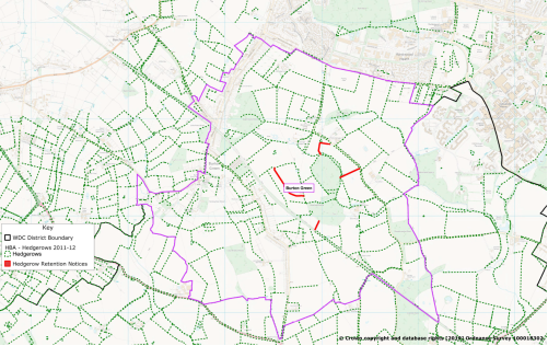
6.1.2. Development proposals should take into account the importance of existing veteran and mature trees, woodland and ancient hedgerows and wherever possible should seek to maintain and protect them (see map 3)
6.1.3. Developments which adversely affects these will not be supported. However, where it is not possible to retain existing trees and hedgerows development proposals which demonstrate full replacement with appropriate native species in mitigation will be supported.
6.1.4. Justification - This supports the realisation of Strategic Objective 2
6.1.5. References:
- NPPF (2019) Paragraphs 170,171,174,175 p49,50
- WDLP NE4 p120
- BGRS Section 4.5 Table 10 p19
-
The Hedgerows Regulations 1997 Section 5 - Removal of Hedgerows;
Section 8 Replacement of Hedgerows -
Independent assessment by APS
6.2. Policy 2 - Wildlife and Biodiversity
6.2.1. Where the removal of woodland or hedgerows is involved in a proposed development, appropriate surveys should be carried out and submitted at the application stage and in all cases prior to determination. Such surveys should include detailed and adequate mitigation measures where a harmful or negative impact has been identified.
6.2.2. Provision should be made for wildlife corridors within developments by preserving existing hedgerows, where possible.
6.2.3. Where possible, all new green spaces within development sites should connect to existing ecological networks adjacent to the site to facilitate free movement of wildlife.
6.2.4. Where appropriate developments should safeguard and enhance the natural environment, protect priority species and enhance habitats and their biodiversity.
6.2.5. Justification - this supports Strategic Objective 1
6.2.6. References:
- NPPF (2019) Paragraph 170a, 170d, 170e, 174, 175 p49,50
- WDLP NE3 Biodiversity p119
- BGRS Section 4.5 Table 10 p19, Chart 13 p21
-
Independent Assessment by APS
6.3. Policy 3 - Public Rights of Way
6.3.1. The existing footpath network within the NDPA (see Map 3) should be preserved and enhanced wherever possible. Any development which adversely affects footpaths, or the amenity of the users of these footpaths, will not be supported.
6.3.2. Further footpaths should be incorporated, where appropriate, into new developments and should demonstrate how the scheme connects with the existing network.
6.3.3. Care should be taken to ensure that where public rights are way are part of a proposed development then:
- Access to footpaths is maintained, including stiles, bridges and steps
- They are made visible and signposted
- Those paths that are not public are, where possible, recognised as permissive rights of way
6.3.4. Justification - this supports the realisation of Strategic Objective 2 and 3c
6.3.5. References:
- NPPF (2019) Paragraphs 91, 98 and 104 p27,28,30
- WDLP TR1 p90, HS1 p96
- BGRS Section 4.6 p23
- CCR Section 5 Activity 3 and 4 p29,32
- Independent Assessment by APS
6.3.6. Community Project 1 - Cycleway linking Cala Homes / Westwood Heath Road housing developments / The Greenway.
The proposal is to develop a cycleway between the above housing developments using existing footpaths (W168 and W169) and back-land development to link in with The Greenway providing a cycleway network within and beyond the NDPA encouraging cycling and walking throughout the NDPA.
The project will also involve securing the necessary permissions for cycles to traverse public footpaths W168 and W169 on NDPA Map 3 showing Footpaths.
Community Project 1 - Cycleway
6.4. Policy 4 - Local Green Spaces (LGS)
6.4.1. Development proposals that would harm the openness or special character of the LGS or its significant value to the local community will not be supported unless there are very special circumstances which outweigh the harm to the LGS
6.4.2. Justification - this policy supports the realisation of Strategic Objective 1
6.4.3. References:
- NPPF (2019) Paragraphs 99,100,101 p29
- WDLP HS3 p98
- BGRS Section 4.5 p19
-
Independent Assessment by APS
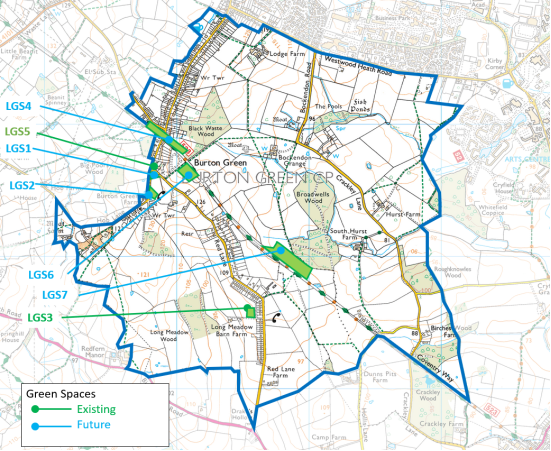
6.4.4. This NDP designates the following areas of Local Green Space (LGS), as shown on Map 5, at the following locations:
|
LGS1 |
The new village green |
|
LGS2 |
Burrow Hill playing field |
|
LGS3 |
Red Lane playground |
|
LGS4 |
Top of the HS2 Cut and Cover Tunnel. LGS4 will be developed as a Community Project. |
|
LGS5 |
The Jubilee Verge - corner of Red Lane / Cromwell Lane |
|
LGS6 |
Land between new village hall and HS2 |
|
LSG7 |
The new tree plantation and wetland area - Land between the Greenway and Broadwells Woods |
6.4.5. Appendix 2 Local Green Space site assessment includes photographs and underpins policy 6.4
6.4.6. Community Project 2 - Cut and Cover Tunnel
The Local Green Space provided by the Cut and Cover HS2 tunnel will be developed into green space for community use. Ideas for this space are being fully investigated in conjunction with HS2 and could include a fitness trail for adults and children, seating areas, sensory trails and wildlife areas. The current Village Hall site should be retained for use as a community car park providing integrated access to the Cut and Cover Tunnel for full community use. Additionally, at the other end of the tunnel, the footpath which runs along the boundary of Black Waste Wood (W169) will become part of the cycleway linking the 2 new housing developments. (see map in Community Project 1) will come up to the tunnel development and then down towards the new Village Hall crossing Red Lane thus completing the connecting cycleway. Funding for this Project will be provided by CIL monies from the new housing developments.
Community Project 2 - Cut and Cover Tunnel
6.5. Policy 5 - Valued Vistas and Landscapes
6.5.1. Development proposals must demonstrate how they are appropriate to and integrate with the character of the landscape setting whilst conserving and where appropriate enhancing the character of the landscape.
6.5.2. Development proposals should ensure that all valued landscapes shown in Map 6 and important vistas and skylines are maintained and safeguarded particularly where they relate to heritage assets, rising land, village approaches and settlement boundaries.
6.5.3. Justification - this supports the realisation of Strategic Objective 2
6.5.4. References:
- NPPF (2019) paragraph 170 p 49
- WDLP NE1 and NE4 p117,120
- BGRS Section 4.1 Tables 1 and 2 p7; Section 4.5 Table 10 p9
- CCR Section 3.2 and 4 p8-10,13-18
- Independent assessment by APS
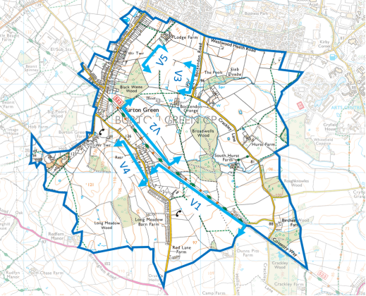
6.5.5. Table 1 - Vistas and their significance
|
View |
Viewpoint |
Significance |
Miles to skyline |
|
VI |
Greenway to the East |
Across best and most versatile agricultural land to Red Lane Houses and beyond provides a strong contribution to local character. It also provides a fine overview of the character of the arable agricultural land within the rising Warwickshire countryside towards the horizon. A view of the Keep of Kenilworth Castle can be seen on the skyline |
5 |
|
V2 |
Greenway to the West |
Currently this view includes Broadwells Wood which is ancient woodland and agricultural land towards Westwood Heath Road and the edge of Coventry. The view will be significantly affected by the HS2 line. |
1 |
|
V3 |
Bockendon Road towards Cromwell Lane |
This open, undeveloped and imposing rising land provides a strong contribution to local character, setting and distinctiveness due to its natural beauty. Additionally, there are unrestricted and commanding views from the road to the skyline dominated by the water tower above Black Wood. |
1 |
|
V4 |
Red Lane to the West |
This view over best and most versatile undulating agricultural land and woodland and extending into open Warwickshire countryside provides a strong contribution due its natural beauty. |
4 |
|
V5 |
From footpath W168 looking south, |
This view from footpath W168 benefits from the elevation of the plateau of the village along Cromwell Lane. It is the most extensive view - to the east over Coventry and the 3 spires, to the west over Kenilworth and the Warwickshire countryside and to the south with Edge Hill and Burton Dasset on the skyline. This view will be affected by the proposed Westwood Heath housing development towards the Coventry skyline. |
18 |
6.5.6. Appendix 3 - Valued Landscapes and Vistas provides photographs from the viewpoints.