Burton Green Neighbourhood Plan - Regulation 16 Submission
2.1. Topological and historical context
This introduction to Burton Green from the BGNPG acknowledges John Webb's blog[1],
The West Midlands Village Book[2], West Midlands Federation of Women's Institutes and the Burton Green History group. [3]
2.1.1. The village of Burton Green is a community of 387 houses (WDLP states about 263 dwellings- the difference may be due to the Village Boundary in the WDLP map which does not include the Kenilworth end of Red Lane nor does it include Long Meadow Farm and Hob lane down to Moat Farm) lying in a semi-rural elevated position between Coventry and Kenilworth. Inset in the Green Belt, the village benefits from open views across the countryside including ancient woods, hedgerows and agricultural land.
2.1.2. The area is bounded by Westwood Heath Road to the north which is on the boundary with Coventry city. The westerly side of the area is on the boundary with Solihull Metropolitan boundary. The southerly boundary is mainly on agricultural land in Warwickshire. The easterly boundary Is again on agricultural land in Warwickshire with the Parish boundary skirting Crackley Wood, Rough Knowles Wood and crossing Whitefield Coppice.
2.1.3. There is little evidence of early history, but a bronze artefact has been found in the Westwood area of the Parish and there is some evidence of Roman activity. Burton Bockendon Grange built by Cistercian monks from Stoneleigh Abbey was featured in early maps and evidence of the monk's fishponds can still be seen. In the Middle Ages the area was divided between three manors, Berkswell, Stoneleigh and Redfern which was part of the Kenilworth Castle Estate. The junction of Red Lane, Hob Lane and Cromwell Lane was a point on the cattle droving road between Wales and London.
2.1.4. There are a number of listed buildings in Burton Green, including Moat Farm in Hob Lane (c1500), South Hurst Farm Cottage in Crackley Lane (1590s), Long Meadow Farm in Hob Lane (1680s) and Arnold's Farmhouse and Barn (circa 1700) in Cromwell Lane. There is one Scheduled monument, The Moat in Bockendon Road. Oliver Cromwell is associated with the area in the civil war period; it is said that he raised his banner in what is now Banner Lane and marched down Cromwell Lane to the royalist Kenilworth Castle. Deeds of houses at the Coventry end of Cromwell Lane, built on land bought from Lord Leigh in the 1920s, record the name of Cromwell Lane from 1946 and this name was formalized for the entire lane in the 1960s.
2.1.5. Burton Green Common was established in 1756 when, after the enclosure of agricultural land in Redfern Manor, land in Hob Lane was set aside for common use. Later, cottages developed here and it became the centre of Burton Green. The Hollies at the Hob Lane/ Cromwell Lane end of Red Lane bears the arms of Lord Leigh and is dated 1859. No.1 the Hollies became the village post office during the early part of the 19th century.
2.1.6. Burton Green School bears a date stone of 1874 (see Photo 1), but there is evidence that the schoolroom was erected possibly as early as 1842, funded by subscription, on land of the Earl of Clarendon. In 1855 the Floyd family of Berkswell set up a trust funded by rental income from land in Birmingham, to cover expenses and maintenance of the school and ensure a Church of England service was held every Sunday, officiated by the Vicar of Kenilworth, for the spiritual benefits of the inhabitants of Burton Green residing a considerable distance from the Parish Church of Kenilworth.
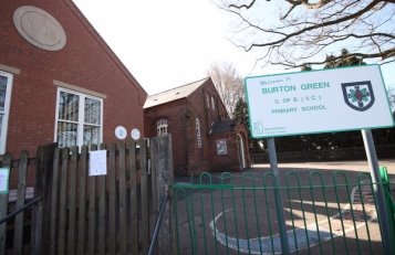
1 - Burton Green School
2.1.7. After the development of the railway through Burton Green in 1884, to connect Kenilworth more directly with Birmingham, steam trains were a feature of the village until the 'Beeching Axe' of 1965. After this the track developed into The Greenway (see Photo 2).
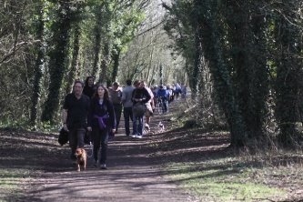
2 - The Greenway
2.1.8. In the 1920s, sale of land from the Leigh Estate led to more houses being built along Cromwell Lane, while in Hodgetts Lane the Village Hall was built, being replaced in 1982 by the present hall. Burton Green's landmark, the Water Tower, was constructed in 1932 and it is in this period that the first semi-detached houses in Red Lane were built. During World War II, families from Coventry came out to BG to escape the bombing; some lived in caravans on Seaton's field while others spent the nights with residents. Housing development continued after the War, with some residents living in sheds or caravans on the land where they built their houses.
2.1.9. BG has developed into a diverse and active community, characterised by a strong community spirit. The School, Village Hall and the Greenway are the hubs and the separate Parish of BG was established in 2011 and enlarged to include parts of Warwick University in 2015.
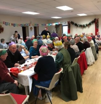
3 - Christmas Lunch at Village Hall
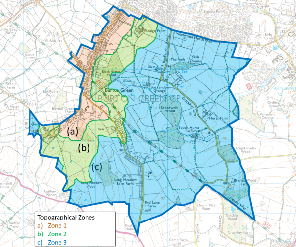
2.1.10. Topologically, the Neighbourhood Area has three, distinct zones (see Map 2):
- Zone 1: The plateau crest which includes Cromwell Lane, Hodgetts Lane and Hob Lane
-
Zone 2: The rising slopes of agricultural land and woodland which includes Red
Lane and the Greenway - Zone 3: The flood plain area of the Crackley gap including Bockendon Road and Crackley Lane
2.1.11. The flood plain and rising agricultural land supports arable farming and grazing meadow. Tourism and recreational activities are supported by the Greenway and associated footpaths. (The Natural England maps show the land grades, and all the fields surrounding the built settlement of Burton Green have a high likelihood (>60%) of being 'Best and Most Versatile (BMV)' land.
2.1.12. Map 3 shows the public rights of way within the Neighbourhood area (see also http://maps.warwickshire.gov.uk/rightsofway/).

2.2. Social context
2.2.1. The age profile of the village from the Housing Needs Survey shows:
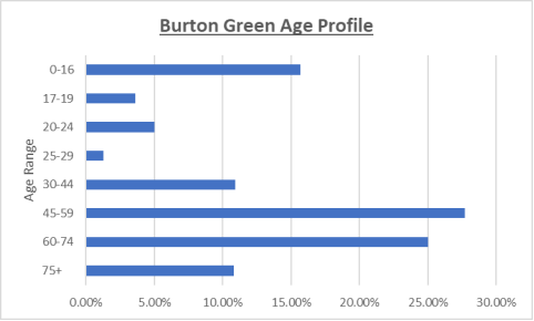
From this the profile it appears that in general there is a good balance of ages of the respondents, although the 30-44 age group is small at 10.9%. The majority of respondents below this age group were living with relatives.
2.2.2. Household size profile shows:
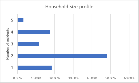
The results show 66% are 1- or 2-person households. Only 13.6% of residents live in a one- or two-bedroom property indicating that there may be a future requirement for smaller properties in the area.
2.2.3. Current housing tenure shows:
One respondent said they lived in a shared ownership property. There were no responses from people living in social housing tenures.
2.2.4. The Property types occupied are:
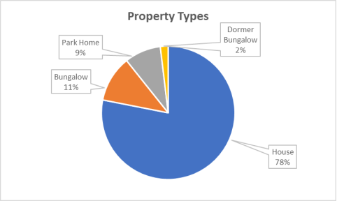
There were no responses from people living in flats or apartments.
2.2.5. The number of bedrooms per property are: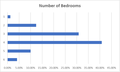
One respondent lives in a 7-bedroom home.
2.2.6. Length of time living in BG: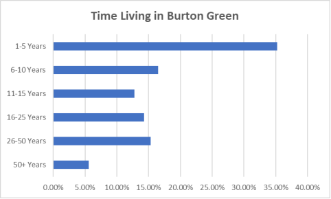
The respondents are individuals, not households, so, for example, a family of four could consist of 2 people living in BG for 10 years, but two young children only for 5 years. Well over 50% of residents have lived in BG for 10 years or more. With the proposed housing developments there will be a significant number of new residents to BG, a change which has influenced the development of the Vision which shapes the NDP.
2.3. Employment
2.3.1. This question was answered in different ways with some residents giving one answer and others multiple answers. What it does show however, is that while 27% of respondents are retired, 16.1% are in education and part of a family unit, which is encouraging for a balanced population in the village. The majority of respondents are in work with only 0.5% saying they are out of work and only 0.4% classed as 'long-term sick or disabled. One person said they are a full-time carer.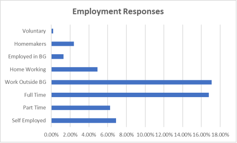
In response to employment location:
Within 'other locations' were a number of people who work at differing locations, including 'the whole of the UK' and 'all over Warwickshire.
2.4. Services and community facilities
2.4.1. The village is currently served by the following bus services:
- A return service between Coventry and Solihull via Burton Green operates hourly with no service on Sunday
- A twice weekly bus to Kenilworth
- School bus to Kenilworth Secondary school am and pm return
- School bus to Heart of England School, Balsall Common am and pm
2.4.2. Whilst the majority (89%) of respondents to the BGNPRS rarely or never use the bus services, 6% use the local bus service at least once a week and 5% once a month. However, 50% of respondents felt improved scheduled times would encourage them to use the local bus services more and 32% asked for more destinations.
2.4.3. The Village Hall offers a place for a range of diverse activities including worship, exercise classes, Baby and Toddler groups, community meetings, and a variety of social events.
2.4.4. The Red Lane children's playground offers a safe environment for toddlers and children to play and enjoy the apparatus in place.
2.4.5. The new housing development on Red Lane / Hob Lane will provide a small village green and a playing field area for use during the day by the Primary School and also villagers.
2.4.6. There are no medical services in the village, although the Village Hall has resuscitation equipment. Most residents are registered with GP practices in Kenilworth.
2.4.7. When asked to rate their satisfaction with the various facilities on offer for BG residents. Their responses illuminate this aspect of the character of BG:
- There was 100% satisfaction for primary education, 95% for secondary education and 93% for preschool and childcare. Satisfaction levels were good for health and welfare - 79%
- Two thirds of residents were satisfied with the provision for arts and culture
- The three services with the lowest satisfaction scores were the facilities for teenagers (15%), for the disabled (31%), and the facilities for pre-teens (35%)