Burton Green Neighbourhood Plan - Regulation 16 Submission
Appendix 2 - Local Green Space Site Assessments
Purpose
An NDP may designate a Local Green Space (LGS) if it meets the criteria of the NPPF2 which states that the designation should only be used:
- Where the green space is in reasonably close proximity to the community it serves:
- Where the green space is demonstrably special to a local community and holds a particular local significance, for example because of its beauty, historic significance, recreational value (including as a playing field), tranquillity or richness of its wild life; and
-
Where the green area concerned is local in character and is not an extensive tract of land.
This appendix contains the assessment of the Local Green Spaces in the NDP area. All the sites assessed are local in character and none is an extensive tract of land.
LGS1 - The 'new' Village Green
|
Site description and current land use |
The 'village green' is being provided by Carla Homes in their development of the Burrow Hill site. It is a small area of land bounded by hedges at the junction of Red Lane with Hob Lane. The area will be grassed. |
|
Planning History |
The area is part of the Cala Homes development of the site agreed by BGPC and WDC |
|
Site ownership |
When completed, the ownership will be taken over by BGPC |
|
Site constraints |
The site is within the NDP Development Boundary |
|
Public Access |
The site adjoins the new housing development |
|
Proximity to the local community |
The site is located within the local community |
|
Ecological significance |
The site bounded by mature hedges on two sides will support and protect the wild life associated with the hedges. |
|
Special qualities and Local significance |
This will be an open area and potential focus point for the new housing development and the whole village |
|
Summary and Suitability for designation as LGS |
The 'new' village green will have recreational significance for the new housing development and have social value as a meeting area. |
No pictures exist as not yet developed
LGS2 - Burrow Hill Park Playing Field
|
Site description and current land use |
This site is being provided by Cala Homes as an aspect of their development of the new housing development. It is designated as a playing field and will be a fenced, flat grassed area |
|
Planning History |
The area is part of the Cala Homes development of the site agreed by BGPC and WDC |
|
Site ownership |
When completed, the ownership will be taken over by BGPC |
|
Site constraints |
The site is within the NDP Development Boundary |
|
Public Access |
The site is within the new housing development with access to all residents and possible usage by the Primary School for recreational/sports activities. |
|
Proximity to the local community |
The site is in the centre of a new housing development and available to the primary school and the rest of the village. |
|
Ecological significance |
The site will be grassed and be an open area |
|
Special qualities and Local significance |
The site provides a green space within the new housing development. The fencing will ensure the grassed area will be free from dogs and the field will be appropriate for use by children, young people and residents of the surrounding houses. |
|
Summary and Suitability for designation as LGS |
It offers a recreational space for children, young people and adults and creates a green space in keeping with Burton Green and the vision of the NDP. |
No pictures exist as not yet developed
LGS3 - The Red Lane Playground
|
Site description and current land use |
The playground is a grassed area, bounded by hedges on 3 sides and a gated fence. There is a range of play apparatus for children including swings, climbing frames, slide, see-saw and goal posts. There is also a picnic table and bench. There is a sign prohibiting dog walking. |
|
Planning History |
The site was originally developed by WDC |
|
Site ownership |
The site has been taken into ownership by BGPC |
|
Site constraints |
The site is outside the village Development Boundary |
|
Public Access |
The site is reached by a drive from Red Lane and is accessible to residents of the village, in the main, those who live adjacent to the playground. |
|
Proximity to the local community |
The playground is situated behind the gardens of the houses on Red Lane |
|
Ecological significance |
The site provides a managed grassed area and is surrounded by hedges which support local wildlife |
|
Special qualities and Local significance |
The site provides a safe play space for local children |
|
Summary and Suitability for designation as LGS |
The playground is an important local facility providing a safe space for children's play and exploration (dens in the hedge). It is maintained and regularly inspected by BGPC to ensure apparatus is up to safety standards |
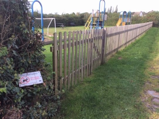
29 - Red Lane Playground
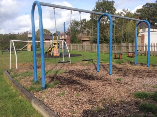
30 - Red Lane Playground
LGS4 - The top of the 'Cut and Cover tunnel' on Cromwell Lane
|
Site description and current land use |
The space will be available on completion of the cut and cover tunnel housing the HS2 line through the village. HS2 will transfer the ownership of the Cover area to BGPC |
|
Planning History |
The cover is part of HS2 construction plans for the HS2 line |
|
Site ownership |
On completion, expected to be BGPC |
|
Site constraints |
The site is within the Development Boundary. The NDP includes the Cover in its project to link the 2 new housing developments and make the area of recreational use by the local community. |
|
Public Access |
Access, still to be developed by HS2, has been promised to enable the space to be used by the local community |
|
Proximity to the local community |
The site is at the centre of the village |
|
Ecological significance |
It will provide a green space above the HS2 line |
|
Special qualities and Local significance |
The cover will provide space for recreation and relaxation (hopefully) after the upheaval of the construction phase of the HS2 line |
|
Summary and Suitability for designation as LGS |
The site is at the heart of the community and will include the Greenway as it passes under Cromwell Lane in a tunnel adjacent to the HS2 line. The cover will therefore be linked to the Greenway and provide recreational space for residents and support the NDP vision in contributing to local cohesion and encouraging cycling and walking. |
No pictures exist as not yet developed
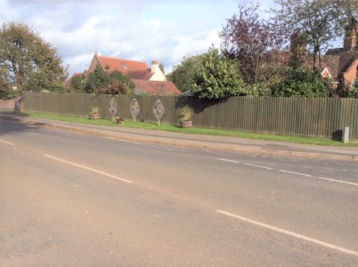
LGS5 - The Jubilee Verge
|
Site description and current land use |
The site is the verge on Cromwell Lane at the junction with Red Lane. The Burton Green Residents Association (BGRA) applied to WDC to develop the verge to mark the Queen's Jubilee in 2012. The verge is grassed with flower tubs, a memorial plaque and 3 mosaics put together by the local community |
|
Planning History |
The verge was owned and maintained by WDC until it was taken over by BGRA. |
|
Site ownership |
The verge was owned and maintained by WDC until it was taken over by BGRA. |
|
Site constraints |
The site is within the Burton Green Development Boundary |
|
Public Access |
Access is directly from the pavement on Cromwell Lane |
|
Proximity to the local community |
The Jubilee Verge could be considered to be at the heart of Burton Green |
|
Ecological significance |
The flowering tubs provide a habitat to be exploited by flying insects and the grassed verge with bulbs planted within it contributes to the green dimension of Burton Green. |
|
Special qualities and Local significance |
The Jubilee Verge showcases the creative side of the Burton Green community. The village Christmas tree takes pride of place on the verge every year and the community gather at the site to celebrate Remembrance Day and light the BGRA beacon in the adjacent field. |
|
Summary and Suitability for designation as LGS |
The area of the Jubilee Verge is small but its position at the junction of Cromwell Lane and Red Lane makes it an ideal site for community gatherings including Christmas carols by the Burton Green Choir. |
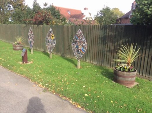
31 - Jubilee Verge
32 - Jubilee Verge
LGS6 - Land between new village hall and HS2
|
Site description and current land use |
The area is currently on HS2 safeguarded land. It borders the Greenway and is currently a mixture of fallow and dug ground due to enabling words |
|
Planning History |
This land is required during construction but will be released once HS2 is built |
|
Site ownership |
The site is currently the responsibility of HS2. On completion of the new Village Hall and the HS2 works it is anticipated that BGPC will take ownership |
|
Site constraints |
The site is outside the Development Boundary |
|
Public Access |
This land lies next to a public footpath, and the Greenway |
|
Proximity to the local community |
The area will be at the heart of the village and benefit from the community use of the village hall. |
|
Ecological significance |
The area will be developed as a community orchard or wild space, with ecological benefits for wildlife |
|
Special qualities and Local significance |
CCR (section 5.4 activity 4) Group D identified a community orchard, including heritage local fruit trees/bushes" as a worthwhile project. Supported by NDPSG this area would be appropriate to develop as a community orchard/wild-space. The project will have considerable community significance. |
|
Summary and Suitability for designation as LGS |
The area is not large but will provide a suitable site for the development as a community orchard. When mature the orchard will be an appropriate backdrop from the Village Hall and Red Lane, softening the impact of HS2 and the cut and cover tunnel portal structure. |
No pictures exist as not yet developed
LGS7 - The new tree plantation and wetland area
|
Site description and current land use |
The site has been defined and planted by HS2 to replace trees destroyed in Broadwells Wood by the construction of the HS2 line. The area is grassland between the Greenway and the new line and will include ponds and native trees. |
|
Planning History |
Part of the HS2 planning process to replace woodland affected by the construction of the HS2 track. |
|
Site ownership |
Currently in HS2 safeguarded land |
|
Site constraints |
The site is outside the development boundary and between The Greenway and the position of the proposed HS2 line. |
|
Public Access |
The site is crossed by Public Footpath W from the Greenway and so is accessible to anyone using the Greenway |
|
Proximity to the local community |
The site is close to the Greenway within the span of Viewpoint V2 |
|
Ecological significance |
The site is an area of regenerating woodland and will provide habitats for plants and wild life associated with woodland and the ponds in the area compensating to some extent for the loss of much of Broadwells Wood |
|
Special qualities and Local significance |
This area of regenerating woodland will shield the Greenway from the HS2 Line and go some way to restoring the valued landscape view V2. Its growth will also mitigate against the loss of areas of Broadwells Wood and fulfil the NDP vision aspiration for residents to enjoy open views over woodland..'' and Objective 1 '' (to) ensure the preservation of the much-valued views of the surrounding open countryside and protect the woodlands, hedgerows and wild life habitats in the NDP area. |
|
Summary and Suitability for designation as LGS |
This site will help restore this part of the NDP area to woodland and provide the local community with the opportunity to explore new woodland at its associated habitats. |
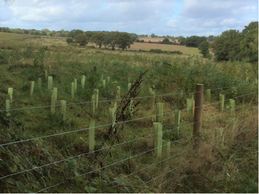
33 - HS2 Woodland Plantation