Burton Green Neighbourhood Plan - Regulation 16 Submission
3.1. Introduction
3.1.1. The VCA aims to establish what makes Burton Green unique and distinctive. It records the important features which contribute to the character of Burton Green drawing on the feedback from extensive consultation with the Burton Green community and describes the key features of the landscape, the built environment and the road network. It is intended to provide a village context for developers, designers and architects to help inform the design of any future residential development proposals and to ensure that any such development is not only of high quality but is also appropriate in character to the surrounding environment and content.
3.1.2. Burton Green is generally washed over by Green Belt, with the exceptions that the WDLP removed land from the Green Belt (H24 for the Burrow Park housing development and H42 for the housing development adjacent to Westwood Heath Road) so that the green belt now washes over all the Neighbourhood Development Plan Area (NDPA) except areas inside the Growth Village Envelope (GVE) and the Burton Green Development Boundary (DB). There is a strong community commitment to preserving the Green belt as evidenced by the results of the BGRS, community Consultation meetings (set out in the CCR) and the evidence base to the BGPP.
3.1.3. The VCA was compiled by a small subgroup of the NDPSG. The subgroup drew on their experience of living in Burton Green for 35 years, a physical inspection of the Burton Green NDPA on foot and bicycle and desk top research to provide evidence in support of the assessment findings.
3.2. Topography
3.2.1. Burton Green is divided into 3 zones for descriptive purposes (see also Map 2 - Topographical Zones Map 2)
- Zone 1 comprising Cromwell Lane, Hodgett's Lane, the top of Red Lane and the top of Hob Lane on land at 125 metres above sea level and above.
- Zone 2, a downward slope descending to 110 metres above sea level including part of Red Lane and Hob Lane
- Zone 3 a rolling area between 110 metres and 80 metres above sea level including the lower parts of Red Lane and Hob Lane, Blind Lane, Crackley Lane, a short section of Cryfield Grange Road and Bockendon Road.
3.2.2. The NDPA is located on the Carboniferous rock of the Warwickshire Coalfield.
3.3. Green/Natural features of the landscape
3.3.1. There are many springs, pools and small streams in Zones 2 and 3
3.3.2. The following table locates the named woods in the NDPA
|
Name of the wood |
Zone Location |
|
Black Waste Wood |
Zone 2 |
|
Broadwells Wood |
Zone 3 |
|
Roughknowles Wood |
Zone 3 |
|
Crackley Wood |
Zone 3 |
|
Long Meadow Wood |
Zone 3 |
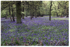
4 - Broadwells Wood
3.4. Agriculture
3.4.1. The following table locates the named farms in the NDPA
|
Farm |
Status |
Access Road |
Zone |
|
Moat Farm |
Non-working |
Hob Lane |
Zone 3 |
|
Long Meadow Farm |
Non-working |
Hob Lane |
Zone 1 |
|
Burton Green Farm |
Working |
Hob Lane |
Zone 1 |
|
Arnolds Farm |
Non-working |
Cromwell Lane |
Zone 1 |
|
Long Meadow Barn Farm |
Working |
Red Lane |
Zone 3 |
|
Red Lane Farm |
Non-working |
Red Lane |
Zone 3 |
|
Old Lodge Farm |
Non-working |
Westwood Heath Road |
Zone 2 |
|
Bockendon Grange Farm |
Non-working |
Bockendon Road |
Zone 3 |
|
South Hurst Farm |
Working |
Crackley Lane |
Zone 3 |
|
Hurst Farm |
Working |
Crackley Lane |
Zone 3 |
|
Birches Wood Farm |
Non-working |
Crackley lane |
Zone 3 |
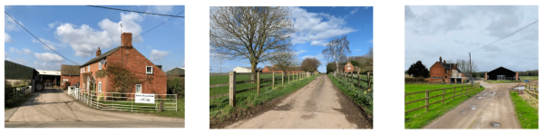
5 - Burton Green Farm, 6 - South Hurst Farm, 7 - Bockendon Grange Farm
3.4.2. The protection of agricultural land from inappropriate development is a high community priority as evidenced by the results of the BGRS the community consultation meetings (set out in the CCR).
3.5. The NDPA road network
3.5.1. The following paragraphs list the roads and lanes in the NDPA and indicates the key features.
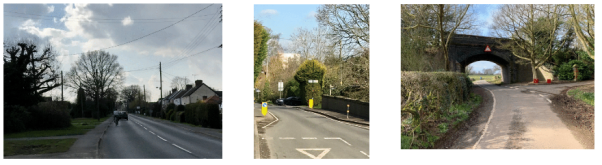
8 - Cromwell Lane, 9 - Cromwell Lane Bridge, 10 - Blind Lane
3.5.2. The 'Welcome to Burton Green' signs are located: on Cromwell Lane about 150 metres from the Cromwell Road/Westwood Heath Road Junction; on Hodgetts Lane approaching the village from Waste Lane; on Hob Lane approaching from Balsall Common; and on Red Lane; approaching from the Kenilworth Road. The Residents Association provide and maintain planted wooden tubs at the welcome signs.
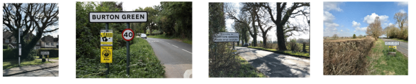
11 - Cromwell Lane, 12 - Hob Lane, 13 - Hodgetts Lane, 14 - Red Lane
3.5.3. The road junctions in Zone 1 (Red Lane/Hob Lane/Cromwell Lane; Hodgett's Lane/Cromwell Lane and Cromwell Lane/Westwood Heath Road) experience significant congestion during the morning and evening rush hours.
3.5.4. The route from Westwood Heath Road via Bockendon Road and Road to Kenilworth in Zone 3 provides a rush hour route for traffic to and from Warwick University and the business parks.
3.5.5. Burrow Park lane provides access from Red lane into the Burrow Park housing development and Leek Green Lane provides the access from Hob Lane.
3.5.6. The Zone 2 hill on Red Lane used to be called Sunny Side Hill by locals and the original Red Lane was a cart track down through Long Meadow Wood which stretched from Hob Lane down to the Kenilworth Road (from a conversation with the tenant farmer of Long Meadow Barn Farm 9/03/2020)
3.6. The NDPA Built Environment
3.6.1. Burton Green is a ribbon development village with most of the housing built along Cromwell Lane, Hodgetts Lane, Hob Lane and Red Lane, mainly in Zone 1.
3.6.2. Zones 2 and 3 housing comprises of ribbon development down Red Lane including Broadwells Wood Park a gated residential park home estate of 32 homes, and scattered clusters of dwellings and isolated houses surrounded by agricultural land, and also along Bockendon Road and Crackley Lane.
3.6.3. The following Table lists the Grade 2 listed heritage buildings and the Scheduled Monument in the NDPA
|
Listed building / Monument |
Date |
Access road |
Zone |
|
The Moat |
Circa 1250 |
Bockendon Road |
Zone 3 |
|
Moat Farm |
Circa 1500 |
Hob Lane |
Zone 3 |
|
South Hurst Farm Cottage |
Circa 1590 |
Crackley Lane |
Zone 3 |
|
Long Meadow Farm |
Circa 1680 |
Hob Lane |
Zone 1 |
|
Arnold's Farmhouse |
Circa 1700 |
Cromwell lane |
Zone 1 |
|
Arnold's Farm Barn Range |
Circa 1700 |
Cromwell lane |
Zone 1 |
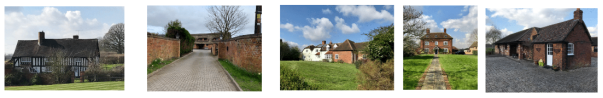
15 - Moat Farm, 16 - Pool Cottage, 17 - Long Meadow Farm, 18 - Arnolds Farm, 19 - Long Meadow
Barn Farm
3.6.4. The barn of Long Meadow Barn Farm is a working barn and dates from 1706. It is timber framed building and is currently unlisted (conversation with the tenant farmer 9/03/2020)
3.6.5. Burton Green is characterized by a variety of dwellings of different styles and designs including bungalows, dormer bungalows, detached and semi-detached houses, and a short terrace of three dwellings.
3.6.6. Apart from the small number of timber framed buildings the majority of houses in Burton Green are built from brick with tiled roofs. A small number of houses are rendered, usually in white with one dwelling Mediterranean blue.
3.6.7. The majority of dwellings have front and rear gardens. Boundaries are defined by hedges, less frequently by fences.
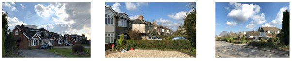
20 - Cromwell Lane, 21 - Red Lane, 22 - Cromwell Lane
3.6.8. There is a small community of Alms Houses on Cromwell Lane managed by Berkswell Charities.
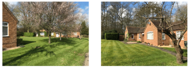
23 - Alms Houses Cromwell Lane
3.6.9. Burton Green has two water towers in Zone 1. The concrete water tower on Cromwell Lane which dominates the village skyline has been converted to a dwelling as has the water tower adjacent to Long Meadow Farm off Hob Lane
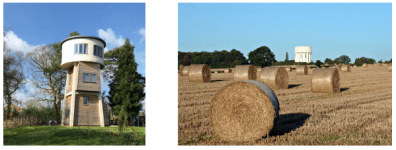
24 - Water Tower Hob Lane, 25 - Water Tower Cromwell Lane
3.6.10. An overview of the development of Burton Green is found at burtongreen.blogspot.com including an interactive map showing buildings colour coded to reflect their dates; the first Ordnance Survey map of around 1831 of Burton Green and accounts from local residents of Burton Green in the 1950's including one by Stuart Barrett building their own family home on Cromwell Lane whilst living in a wooden shack.
3.6.11. The following photographic montage shows the street scenes throughout the NDPA and captures aspects of the built environment in support of the Village Character Assessment.
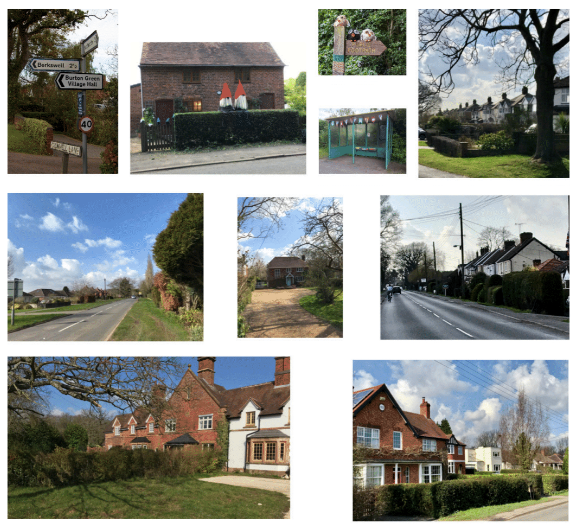
26 - Top Left to Bottom Right
Road Signage on Cromwell Lane / House on Hodgetts Lane / Greenway signage/ Bus Shelter
Red Lane / Red Lane / Cromwell / Cromwell Lane / Red Lane / Cromwell Lane
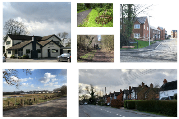
Photo 27 - Top Left to Bottom Right
Restaurant on Cromwell Lane / Greenway Art / Greenway track / Burrow Hill Park- Red Lane
Broadwell Woods Park - Red Lane / Cromwell Lane