Baginton and Bubbenhall Neighbourhood Plan
(6) 2.0 Planning Policy Context
2.1 Neighbourhood plans have to be in "general
conformity" with strategic local planning policies, and have
appropriate regard to national planning policies and it is
therefore important that as the Plan is prepared, the policies
reflect this higher-level planning framework. This Neighbourhood
Plan has been prepared within the policy framework of the Saved
policies of the existing Warwick Local Plan, in line with national
planning guidance and takes into consideration the emerging new
Local Plan 2011 - 2029.
National Planning Policy (NPPF)
2.2 National planning policy is set out in the
National Planning Policy Framework (NPPF)1 published in 2012. This
advises in paragraphs 6 and 7 that the purpose of the planning
system is to contribute to the achievement of sustainable
development, and that the planning system has to perform an
economic role, a social role and an environmental role.
Neighbourhood planning is addressed in paragraphs 183-185:
183. Neighbourhood planning gives communities
direct power to develop a shared vision for their neighbourhood
and deliver the sustainable development they need. Parishes and
neighbourhood forums can use neighbourhood planningto:
- set planning policies through neighbourhood plans to determine decisions on planning applications; and
- grant planning permission through Neighbourhood Development Orders and Community Right to Build Orders for specific development which complies with the order.
184. Neighbourhood planning provides a powerful set of
tools for local people to ensure that they get the right types
of development for their community. The ambition of the
neighbourhood should be aligned with the strategic needs and
priorities of the wider local area. Neighbourhood plans must be
in general conformity with the strategic policies of the Local
Plan. To facilitate this, local planning authorities should set
out clearly their strategic policiesfortheareaandensurethatanup-to-dateLocalPlanisinplaceasquicklyaspossible.
Neighbourhood plans should reflect these policies and
neighbourhoods should plan positively to support them.
Neighbourhood plans and orders should not promote less
development than set out in the Local Plan or undermine its
strategicpolicies.
185. Outside these strategic elements, neighbourhood
plans will be able to shape and direct sustainable development
in their area. Once a neighbourhood plan has demonstrated its
general conformity with the strategic policies of the Local Plan
and is brought into force, the policies it contains take
precedence over existing non-strategic policies in the Local
Plan for that neighbourhood, where they are in conflict. Local
planning authorities should avoid duplicating planning processes
for non-strategic policies where a neighbourhood plan is in
preparation.

Warwick District Planning Policy Context
2.3 Baginton and Bubbenhall are located in the local
authority area of Warwick District Council. The 'saved' policies
of the Warwick District Local Plan (1996-2011) (as amended
September 2007)2 provide the current local planning policy
framework for the area pending the adoption of the emerging
Warwick District Local Plan 2011-2029.
2.4 Warwick District Council is preparing a new Warwick
District Local Plan 2011 – 20293. The Local Plan was submitted on
30th January 2015 for Examination, along with focused changes
which were consulted upon in autumn / winter 2014. Warwick
District Council received the Inspector's findings regarding key
aspects of the Local Plan in June 2015.4
2.5 Since then Warwick District Council has undertaken
additional work to identify sites to meet the additional
requirement of approximately 5,200 dwellings over and above those
in the submitted Local Plan. The proposed modifications to the
Local Plan were published for consultation in March 2016, and this
consultation closed on 22nd April.
2.6 The Local Plan Examination Hearings were convened
and then formally closed by the Inspector, Mr Kevin Ward on 15th
December. The Inspector has stated that main modifications are
required to make the submitted plan sound. He will be liaising
with the council to produce a schedule of proposed main
modifications and these will be subject to full public
consultation and Sustainability Appraisal (SA) over the coming
months. The Inspector will take account of comments on the
proposed main modifications and the SA before finalising his
report to the council.5
2.7 In the meantime, work on the Neighbourhood Plan
will continue, and as the position with the Local Plan becomes
clearer the NDP may have to be amended and updated.
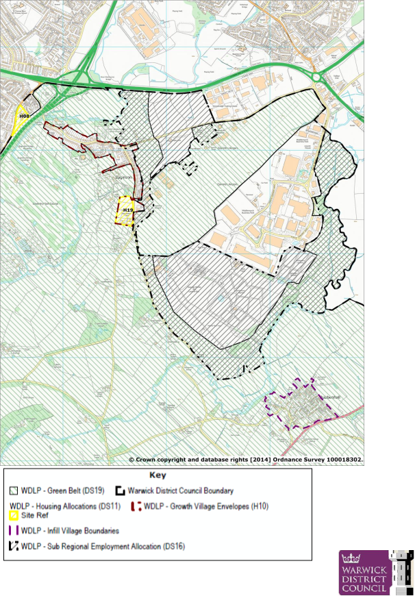
Map 2. Baginton, Bubbenhall and Coventry Airport
(Proposed Mod. 2016) Local Plan
Policies Map
Bubbenhall Parish Council (Licensee) License No. 100051733
Housing
2.8 The emerging new Warwick District Plan
identifies in Policy H1 that Baginton is a Growth Village and
Bubbenhall is a Limited Infill Village. Baginton is inset within
the green belt (although in the adopted Local Plan it is washed
over) and Bubbenhall is washed over by the green belt with an
identified infill village boundary on the proposals map. The need
to preserve the openness of the green belt as a buffer between the
villages and surrounding towns is a strategic matter for Warwick
District, but the neighbourhood plan has a role in ensuring that
local distinctiveness and the rural character of the parishes is
protected. Both Parish Councils support full retention of the
green belt between Coventry and Baginton, to maintain the openness
of the green belt and protect the community against the urban
sprawl of Coventry into rural Warwickshire.
2.9 Policy DS10 Broad Location of Allocated
Housing Sites identified that sites within the Growth Villages and
rural area should provide 763 new houses over the plan period (up
to 2029). These projections have now been increased in the
proposed modifications to 1146. Policy DS11 Allocated Housing
Sites identified Site H19 Baginton – Land north of Rosswood Farm
for 35 housing units and a green field site (H08) is identified
within the Parish on the edge of Coventry at Oaklea Farm, Finham
for 20 houses. The proposed modifications have increased the
number of proposed houses on land to the north of Rosswood Farm
(H19) to 80 units. Policy DS16 identifies Land in the vicinity of
Coventry Airport (235 ha) as a Sub-Regional Employment Site for
B1, B2 and B8 uses, an area known as the Coventry Gateway. (There
is some uncertainty about the future of the site following a
recent appeal decision which was called in by the Secretary of
State and dismissed for reasons including that the proposal would
prejudice the outcome of the Local Plan and that the proposal
would have an adverse impact on the openness of the green belt.)
2.10 On 26th April 2016 Warwick District
Council granted planning permission to Coventry City Council and
Jaguar Land Rover to develop approximately 260 acres of Green
Belt, of which 70 acres is to provide an extension to Whitley
Business Park south of the A45 in the Parish of Baginton. The site
proposed for development is identical to that of Zone B of the
Coventry and Warwickshire Gateway. The Parish Councils expressed
their opposition to the application and requested that it should
be called in by the Secretary of State. This was refused. However,
the Parish Councils continue to support the view that the land
south of Coventry is not developed to maintain the openness and
effectiveness of the Green Belt and protect against urban sprawl
in accordance with the NPPF.
2.11 The Warwick Village Housing Options and
Settlement Boundaries Consultation Warwick District Council
November 20136 notes (in para 2.6) that the age structure of the
rural areas is changing, with a loss of younger people and
increase in older residents. 13 out of the 17 rural areas have
witnessed a decrease in the percentage of 0-15 year olds compared
with a district trend of just over 1% increase (the West Midlands
trend is for a 1.3% increase during the two census periods). In
line with District trends 16 out of 17 rural areas have witnessed
a reduction in the percentage of 30-44 year olds. The district
trend is -1.61%.
2.12 The report goes on to say that the
challenge in relation to village housing is two-fold:
1. It requires firstly an approach to addressing
current housing trends and requirements. This meanslookingatopportunitiestoprovidemoremovementinlocalhousingmarketstoenable
older people to downsize or move to different types of housing.
It also requires the provision of housing that is adaptable to
changing circumstances and physicalrequirements.
2. If we are looking to help 're-balance' the
population profile of our rural areas and villages, thiswillrequirethesupplyofnewsitesforhousing,whichwillnotonlyhelpaddressindigenous
local housing requirements (including affordable homes) but also
support the wider housing growthdemandsforthedistrict.Partofthisre-balancingmayincludediversifyingthehousing
stock range to include the provision of smaller family and 2
bedroom homes appealing to differentdemographics.
2.13 The Strategic Housing Market Assessment, Final Report, March 20127 found that the calculated level of housing need in Warwick District is high with all areas also showing a significantneedforadditionalaffordablehousingtobeprovided…Itisconsideredthatmarket demand will be strongest for 3-bedroom properties (43%). Demand for 1-bed properties is expected to be relatively limited (7%). With the ageing of the population, some households occupying larger market homes (4+ beds) may downsize, releasing these properties for younger households. Thus, demand for 4+ bed homes is likely to be slightly more moderate than in the past. An estimated 42% of overall housing requirements (market and affordable) are for 3-bed properties, 20% for 4 or more bedrooms, 26% for 2-bed properties and 12% for 1-bed properties. Around 60% of requirements are thus for family housing with 3 or more bedrooms. This mix should be taken into account in considering the 'portfolio' of sites taken forward through the Local Plan…. For affordable housing, taking account of identified need, existing supply and turnover of properties and issues related to the management of the housing stock, the Assessment recommends a policy target for 15%-20% of future affordable housing provision to be 1-bed properties, 30% of 2-bed, 40% of 3-bed, and 10-15% with 4 or more bedrooms. It is also recommended that the vast majority of 2-bed homes are built as houses/bungalows rather than flats. In addition, 22% of households in the District contain only older persons (with more than 25% in Rural East area which includes the parishes of Baginton and Bubbenhall).
2.14 There may also be opportunities for small scale
self- and custom-build and self-finish schemes on small scale
local sites within the villages.
Green Belt
2.15 The above policies and proposals could have
significant impacts on local communities living within the
neighbourhood plan area. The recently published Joint Green Belt
Review (LUC London Stage 1 Final Report 2015)8 emphasises the
effectiveness of green belt in the area of both Parishes,
particularly the section to the south and west of Coventry, where
the green belt serves to contain the potential urban sprawl of
Coventry. Green Belt 'parcels' 9 and 10
score 14/20 and 16/20 for effectiveness in the Review and comprise land which under policy DS19 of the draft Local Plan is to be removed from Green Belt to make way for a major employment site (Policy DS16). It concluded that the Green Belt between Coventry and the villages is highly rated. It should remain. Despite the findings of the Joint Green Belt review, in granting permission for planning application W/16/0239 Warwick District Council have chosen to develop the higher performing Green Belt parcel C10. (In addition, details of the major employment site are based on the Gateway have been rejected by the Secretary of State and the Parish Councils support this approach). The traffic generated by the proposed Employment Site rejected by the Secretary of State and one of the elements of which is a large distribution hub, would place unsustainable demands on the network of local roads within and around the communities which link them to the A45 and A46.
Flooding
2.16 Flooding of the Avon and the Sowe is a potential
risk in the future, which would impact on the edge of Bubbenhall
where it serves as a natural boundary. The sewers and drains in
Bubbenhall are at capacity and flash flooding occurs on Stoneleigh
Road and the junction of Cooper's Walk and Lower End.
Conservation and Heritage
2.17 In addition to the planning policy constraints
placed upon the NDP in terms of the Parishes' location within the
green belt, both villages have conservation areas focussed around
the historic cores of the villages. Baginton Parish has 13 listed
buildings including the Grade I Listed Church of St John the
Baptist and scheduled monuments at Baginton Castle and the Roman
Fort at the Lunt. There are 9 listed buildings in Bubbenhall
including a scheduled monument "Pit alignments north of Bubbenhall
village"9. These are provided in Appendix II.
Site of Special Scientific Interest (SSSI)10
2.18 Waverley Wood Farm was designated as a SSSI in
August 1996. It is a 0.9 ha site south of Bubbenhall. It lies
within Bubbenhall Wood, adjacent to a large sand and gravel pit,
currently undergoing landfill. This site provides an important
reserve of an interglacial deposit, uniquely preserved here
beneath the more widespread local drift sequence. The interglacial
beds occupy a channel cut in Mercia Mudstone bedrock. They are
overlain by Baginton-Lillington Gravel, Baginton Sand and
Thrussington Till. The interglacial sediments have yielded plant
remains, including pollen, as well as molluscs, vertebrate
remains, ostracods and insects. The deposits are of exceptional
importance in understanding the succession of glacial events
within the British Isles.
Ancient Woodlands 11
2.19 The main Ancient Woodlands recorded in Warwick
District are listed in Appendix 3 of the Adopted Local Plan 1996 –
2011. Those in the neighbourhood area are:
- Bubbenhall Wood, Bubbenhall
- Shrub Wood (part of Ryton Wood), Bubbenhall
- Weston Wood, Bubbenhall
- Waverley Wood, Bubbenhall.
Landscape – Natural England National Character Areas
2.20 Natural England has produced profiles for
England's 159 National Character Areas (NCAs). These are areas
that share similar landscape characteristics, and which follow
natural lines in the landscape rather than administrative
boundaries, making them a good decision-making framework for the
natural environment. Baginton and Bubbenhall lie within two
National Character Areas:
NCA 96: Dunsmore and Feldon12 NCA 97: Arden13
2.21 The two Parishes are aiming to work more closely
with the Warwickshire Trust on the Princethorpe Woodlands Living
Landscape Project, which includes "themostimportantcluster
of ancient woodlands in Warwickshire" within the Parish
boundaries. The aim of the Trust is to protect and enhance
wildlife, natural habitats and geology; to restore an ancient
woodland landscape connected by hedgerows, grasslands, trees and
ponds, full of historical sites, to one rich in wildlife and
accessible to all. Funding is in place from the Heritage Lottery
Fund to carry out this work. Working with local partners,
landowners and communities the project would hope to:
- Restore and enhance the natural and historical heritage of the landscape, improving habitats and increasing connectivity for wildlife (green corridors) and also conserving historical sites;
- Improve physical access to heritage sites;
- Improve access to information about the area;
- Provide learning and training opportunities.
- By taking a landscape scale approach to restoration and conservation and by engaging local communities, the project will create a sense of ownership and understanding that will ensure the continuity of the Princethorpe Woodlands Living Landscape. The Parishes of Bubbenhall, and Baginton are within the area that this project covers.
1 https://www.gov.uk/government/publications/national-planning-policy-framework--2
2 http://www.warwickdc.gov.uk/info/20376/planning_policy/268/local_plan_1996_-_2011
3 http://www.warwickdc.gov.uk/info/20410/new_local_plan
4 http://www.warwickdc.gov.uk/news/article/73/inspectors_report_-_local_plan
5 https://www.warwickdc.gov.uk/info/20410/new_local_plan
6 http://www.warwickdc.gov.uk/info/20410/new_local_plan/822/village_housing_options_consultation
7 http://www.warwickdc.gov.uk/downloads/file/55/warwickshmareportfinal_pdf
8 West Midlands Joint Green Belt Study, 2015 http://www.warwickdc.gov.uk/downloads/download/744/joint_green_belt_study_2015
9 Historic England https://www.historicengland.org.uk/listing/the-list/
10 http://www.sssi.naturalengland.org.uk/citation/citation_photo/2000087.pdf
11 http://www.warwickdc.gov.uk/info/20376/planning_policy/268/local_plan_1996_-_2011
12 http://publications.naturalengland.org.uk/publication/4878893332824064?category=587130
13 http://publications.naturalengland.org.uk/publication/1819400?category=587130