Draft Kings Hill Masterplan and Design Code Supplementary Planning Document
4 Constraints and Opportunities
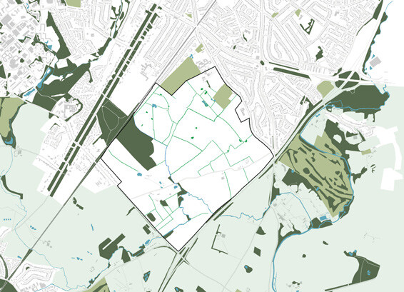
4.1 Key Constraints
A review of previously completed constraints and technical assessments has been undertaken to inform a summary of the site’s key technical constraints.
Figure 28 illustrates the location of the site’s key constraints. The following provides a summary of constraints by theme:
4.1.1 Air Quality
The A46 road corridor could potentially contribute to reductions of air quality. A ‘stand-off-distance’ from the A46 to the nearest residential dwellings could limit potential exposure from increases in road traffic-related pollutants. With respect to current and future national air quality objectives, there is scope for further detailed assessments.
Finham Wastewater Treatment Plant (WWTP), operated by Severn Trent, is located within 200m of the site to the east. Stakeholder engagement with Severn Trent would be prudent to further understand if there is a ‘cordon sanitaire’ policy in place, which would impact the proximity of new development parcels.
4.1.2 Land Quality
No significant constraints. Known hotspots of contamination were identified during previous ground investigation works across the original masterplanning area, requiring further investigation.
Available Ordnance Survey map data indicates several potential discrete areas of artificial ground (infilled historic ponds) which may present a contamination and/or ground instability risk without prior investigation and, where required, remedial works.
The presence of groundwater abstraction wells and associated source protection zones located at the northern extent of the masterplanning area will require a level of mitigation measures in place during construction activities to ensure the corresponding aquifer(s) are suitably protected.
4.1.3 Access
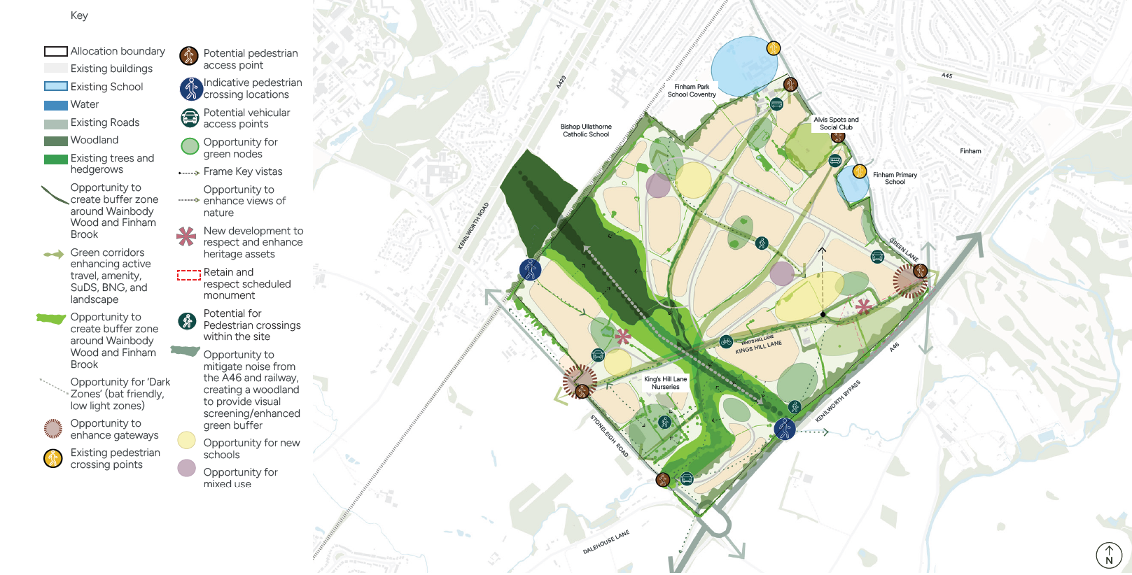
The proposed St. Martins Road roundabout access junction may be difficult for pedestrians and cyclists to negotiate. There is potential for on-street parking to block Green Lane accesses during school drop-off and pick-up times. King’s Hill Lane is currently subject to a 60mph speed limit and has no active travel infrastructure. Some access to properties will need to be retained and managing conflict will need to be considered carefully. There are existing hedgerows along either side of King’s Hill Lane which, in places, may constrain visibility for pedestrians, cyclists and car drivers.
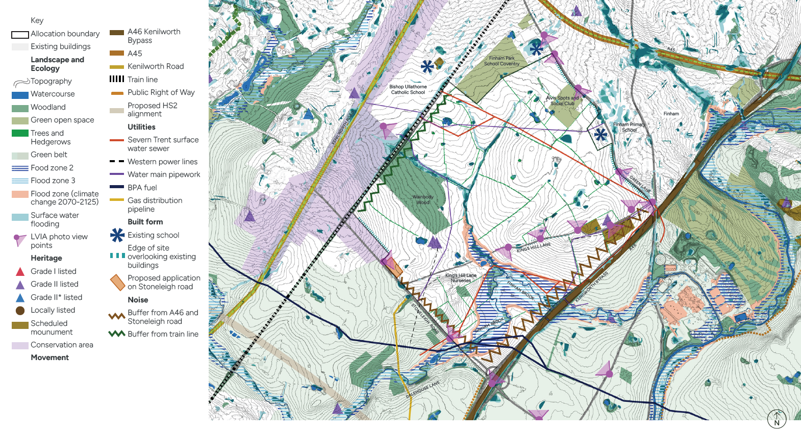
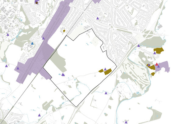
4.1.4 Heritage and Archaeology
A Local Geological Site (LGS), King’s Hill Boulder Part LGS is a large glacial erratic boulder, historically important for understanding glacial processes in Warwickshire. It was formerly a geological SSSI but now de-scheduled. It is located near King’s Hill Farm.
There are several listed buildings along King Hill Lane, the Scheduled Ancient Monument, the ancient village of ‘Kings Hull’, which is a deserted village, Kenilworth Conservation Area is located to the east of the site.
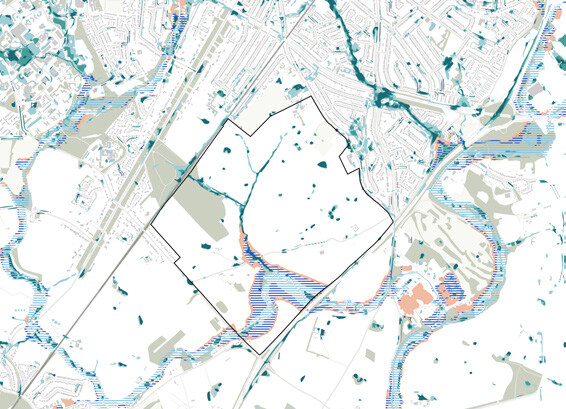
4.1.5 Hydrology
Finham Brook flows through the study area in a generally north-easterly direction before discharging close to the River Sowe at the Severn Trent Water Finham Sewage Treatment Works.
Areas of the site around Finham Brook are in Flood Risk Zone 2 and 3. Modelling for Fluvial and Surface Water Flooding was carried out as part of the Lioncourt application in 2017 and also shows flood risk areas beyond the Flood Zones around Finham Brook and Wainbody Wood.
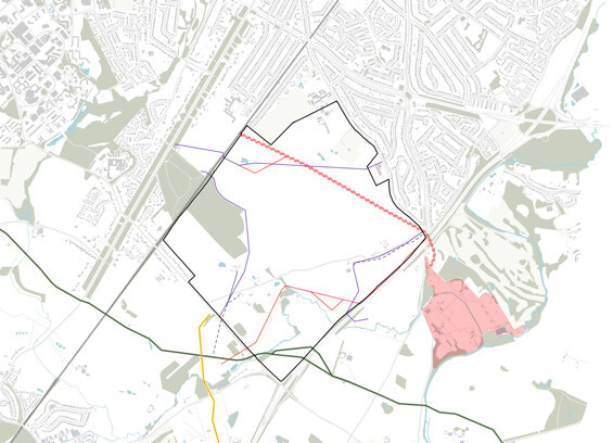
4.1.6 Utilities
1350mm diameter combined sewer that runs across the allocated site, which is fed by a 675mm diameter combined sewer on the western area and a 375mm diameter foul water sewer on the eastern side of the allocation area.
4.1.7 Ecology
The site contains sensitive ecological assets shaping the development layout. Wainbody Wood is an Ancient Woodland and Local Wildlife Site, requiring protection, buffering, and enhancement. Finham Brook is a high-value ecological corridor. Habitats include semi-natural woodland, hedgerows, marshy grassland, waterbodies, and mature trees.
Development must maintain ecological connectivity, provide appropriate easements and buffers, and consider Biodiversity Net Gain requirements, with a particular focus on on-site retention and enhancement of watercourses, ponds, and key landscape features.
4.1.8 Topography and Views
The highest publicly accessible point along King’s Hill Lane with elevated, panoramic views.
There are long-range views north towards Coventry skyline and Cathedral spire.
Woodland and tree-lined hills are visible to the east and south-east.
Southern views include the A46 Stoneleigh Roundabout and bridge. Strong visual connection to Wainbody Wood and Finham Brook.
Landform falls gently towards the Finham Brook to the south points King’s Hill Lane.
4.1.9 Landscape
The area is characterised as Arden Parklands Landscape Type, an enclosed, gently rolling landscape defined by woodland edges, parkland and belts of trees.
Mature vegetation at the internal and outer boundaries of the site, combined with the undulating landform, creates a high level of landscape enclosure.
Sensitive landscape features include the open, high ground, particularly around King’s Hill. Ecological and heritage elements including Finham Brook.
Distinctive features contribute positively to local existing landscape character, distinctiveness and identity:
- Mature trees along King’s Hill Lane and Stoneleigh Road.
- Distinctive avenue of trees and field patterns in the southwestern corner.
- Finham Brook, its tributaries, and interplay with the topography of King’s Hill Lane.
- Wainbody Wood and the small woodland blocks throughout the site.
- Southeastern area, around Pinham Brook, situated in the Arden Parklands enhancement zone, a priority area for targeting landscape and habitat restoration.
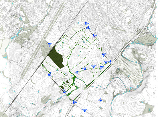
4.2 Key Opportunities
Following the technical and constraints review, key opportunities have been identified across the site and illustrated in Figure 29.
Development on the site should consider the following key opportunities:
Protect and enhance existing landscape assets, such as existing hedgerows and trees, achieving 10% BNG for additional masterplan areas.
- Potential to retain important landscape features and create a dedicated safer pedestrian and cycle access along King’s Hill Lane.
- Opportunity to enhance entrances with new gateway development and arrival space
- Create vibrant community hubs, with a mix of facilities including shops, schools and parks.
- Deliver walkable and liveable neighbourhoods, with dedicated walking and cycling routes connecting facilities, promoting active travel and reducing reliance on the car for shorter trips.
- Create green spaces for all and a network of accessible parks, located at key activity nodes.
- Provide green corridors to enhance east-west movement, active travel, amenity, SuDS, BNG, and landscape.
- Opportunity to mitigate noise from the A46 and railway, with landscape buffers that provide visual screening and an enhanced green buffer.
4.3 Spatial Design Principles
Spatial design principles have been established to underpin and shape the masterplan. The design principles set out our design priorities for the masterplan and establish our intent for the design guidance and codes.
The principles respond to the landscape, ecology and heritage context, while shaping a connected, people-focused neighbourhood with a strong sense of place.
- Together, the principles ensure that development:
- Protects and enhances existing natural and environmental assets
- Creates safe, walkable and well-connected movement networks
- Prioritises people, community and wellbeing
- Delivers a distinctive place with a clear identity and memorable arrival points
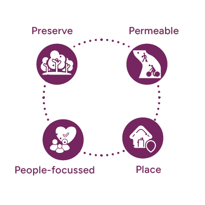
The principles work collectively to inform layout, movement, landscape and built form, ensuring a high-quality and sustainable development. Figure 26 illustrates four overarching themes: Preserve, Permeable, Place and People-focussed.
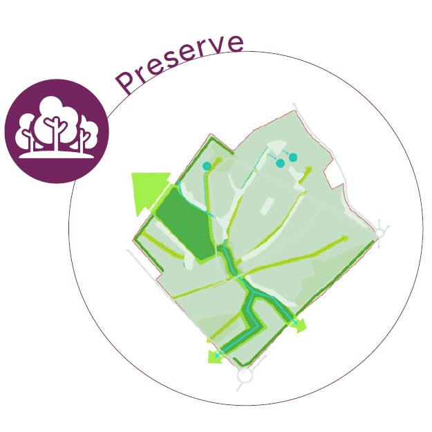
Protecting Landscape, Ecology and Natural Assets
This principle is about preserving and enhancing high-quality habitats within the site:
- Preserve high-value ecological areas and key wildlife corridors, including Wainbody Wood and Finham Brook, with safeguarded land to strengthen connections between them.
- Retain and protect existing hedgerows and mature trees across the site.
- Create new natural parkland areas to maintain openness and enhance wildlife habitats.
- Strengthen planting along site edges to reduce air quality, noise and visual impacts from the A46 and protect the setting of the Kenilworth Road Conservation Area.
- Preserve existing ponds and watercourses and enhance surrounding wildlife corridors, strengthening their ecological and landscape setting across the site
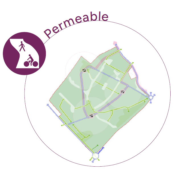
A Connected and Accessible Neighbourhood
Prioritising connections is a key design driver for the site.
Whilst the railway line along the western edge and the A46 along the eastern edge act as barriers to movement, there is opportunity in north-south movements, prioritising desire lines for pedestrians and cyclists:
- Prioritise strong north–south pedestrian and cycle connections, reflecting key desire lines through the site and introduce a new primary route through the site, designed to accommodate buses and sustainable transport.
- Create new east–west connections that prioritise pedestrians and cyclists, linking neighbourhoods to schools, community facilities and open spaces.
- Upgrade Stoneleigh Road to improve pedestrian connectivity to the local area and ‘A Coventry Way’ 40 mile circular walk accessed from the A46 Kenilworth Bypass/Stoneleigh Road junction.
- Provide new accessible links to existing facilities in the wider area.
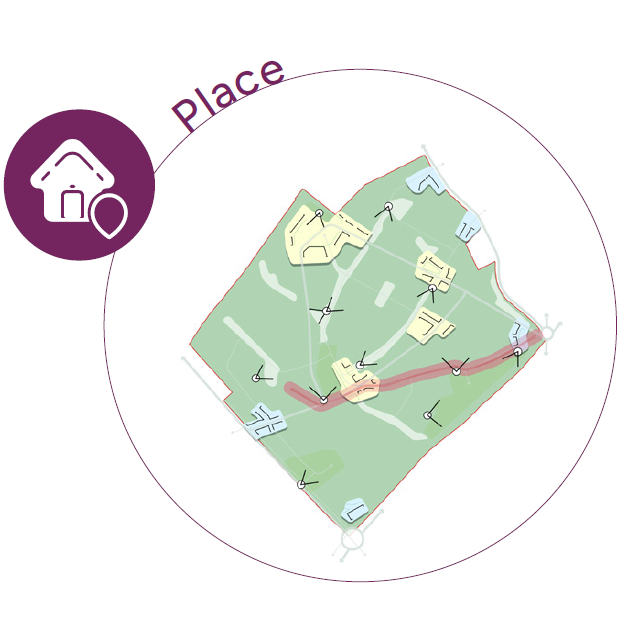
Distinctive Character and Strong Identity
This design principle is two-fold, it is about enhancing the arrival experience into the site, to make it welcoming and accessible, but also about celebrating the heritage assets within the site, the scheduled ancient monument and the listed buildings along King’s Hill Lane:
- Create an enhanced arrival experience at key junctions into the site, through strong building lines, landmark buildings and varied building heights.
- Establish a heritage corridor along King’s Hill Lane, prioritising design which responds to the character and setting of existing farmsteads and residential buildings.
- New nodes - celebrate the new local centres and key junctions, using architecture, built form and landscape to define a memorable and welcoming gateway.
- Frame and enhance long range views and glimpse views to the existing landscape, parks and green spaces.
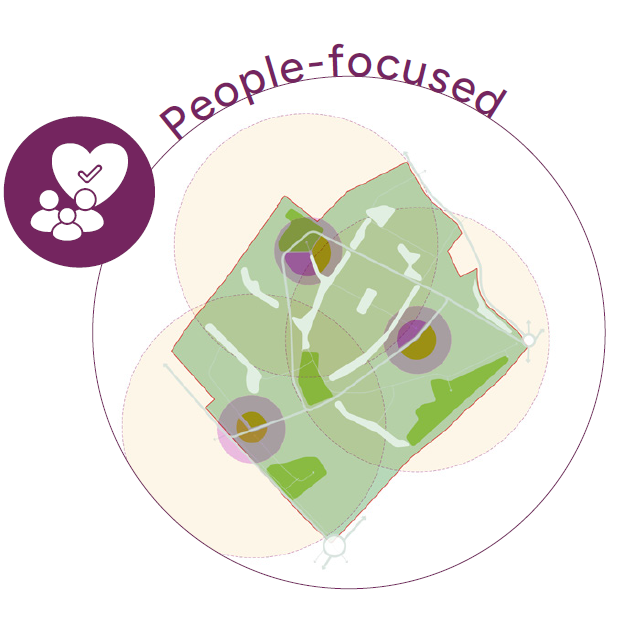
Creating Inclusive, Healthy Communities
There is an opportunity to create new neighbourhoods, with facilities at the heart of each community including new schools, local centres and neighbourhood parks.
This builds upon the ‘20 minute neighbourhood’ concept, which allows residents to access key services within a 20 minute walk:
- Deliver well-located community hubs that are easy to walk to and clustered for convenience and activity.
- Provide new neighbourhood parks at the heart of each community, encouraging access to open space and views of nature.
- Include allotments to promote local food growing, wellbeing and a strong sense of community.
- Respond sensitively to existing neighbours through landscape buffers, shared parks and accessible green spaces for both new and existing residents.