Draft Kings Hill Masterplan and Design Code Supplementary Planning Document
3 Context
3.1 Local Townscape
A townscape character study for King’s Hill Lane was carried out to understand how the local area.
This has evolved and to identify key townscape characteristics which could positively influence new development on the King’s Hill Lane site. The study can be read in Appendix 8.6.
Historic maps from the mid to late 1800s show field boundaries still recognisable today, with the Coventry-Leamington railway line already defining the sites western edge.
Nearby villages such as Baginton, Stoneleigh, Kenilworth and Canley originated as small rural settlements with distinct characters attributed to historic buildings and medieval cores.
Coventry’s suburban expansion in the mid‑20th century gradually extended development right up to the northern boundary of the site. By the 1970s/1980s, the newly constructed A46, now defining the sites eastern edge, was connecting these new neighbourhoods (equipped with new schools and facilities) to the wider local area.
By the 2020s, the surrounding settlements had further changed through industrial development, around Coventry Airport, new infrastructure such as HS2, and new housing growth, often piecemeal along the edges of the settlement boundary.
A site visit undertaken in November 2026 assessed five surrounding areas:
King’s Hill Lane is rural in appearance, with hedgerows, mature trees and agricultural land, alongside a mix of historic farmsteads and more modern commercial and nursery buildings. Views from higher points along the lane provide long‑distance outlooks towards Coventry city centre and the Kenilworth Bypass.
Finham, located to the north, is characterised by consistent 1930s-1950s suburban housing, with strong architectural rhythm created by repeated rooflines, bay windows and symmetrical elements, though later property extensions have varied its appearance. The public realm includes uniform pavements and tree‑lined verges.
The Shrubberies, to the west, contains low‑density housing, primarily bungalows from the 1960s and 1970s, transitioning into 1930s-40s Arts and Crafts homes further north. It has a clear settlement‑edge quality, strengthened by nearby open spaces and the wooded buffer at Gibbet Hill Wood.
Stoneleigh Road is notable for its large, detached homes, many within a conservation area, displaying a wide range of architectural styles and framed by mature trees, wide verges and a semi‑rural road character.
Kenilworth High Street is described as a historic market‑town centre shaped by landmarks such as Kenilworth Castle and St Mary’s Abbey, and characterised by historic buildings, dense streets, traditional buildings, cobbled areas, street trees and a strong sense of enclosure.
Stoneleigh Village was also identified as an important local character area, with several buildings dating to the mid-1800s and earlier (the red stone Almhouses were built in 1594). The material palette of buildings in the centre, featuring red sandstone, red brick, and timber-framed features, creates a strong sense of identity. Green verges and small terraced front gardens with stone walls and steps add to the distinct character.
Local Character Study Key Considerations
- In the northern, more urban areas, streets should use a consistent building line with repeated architectural features to create a clear suburban character.
- At the rural edges, buildings should have a looser, more informal building line with larger setbacks to emphasise the transition to open landscape.
- Green spaces and village greens should frame key nodes and soften denser housing areas.
- Street trees should be used to reinforce the street hierarchy.
- Local squares in key centres should create arrival points and spaces for community activity.
- Parking areas should be improved through landscape design, such as using cobbles and tree planting.
- Local architectural styles and materials from places like Kenilworth and Stoneleigh should guide design of landmark buildings to strengthen contextual identity.
- Key views/ vistas towards Coventry should be considered through the layout
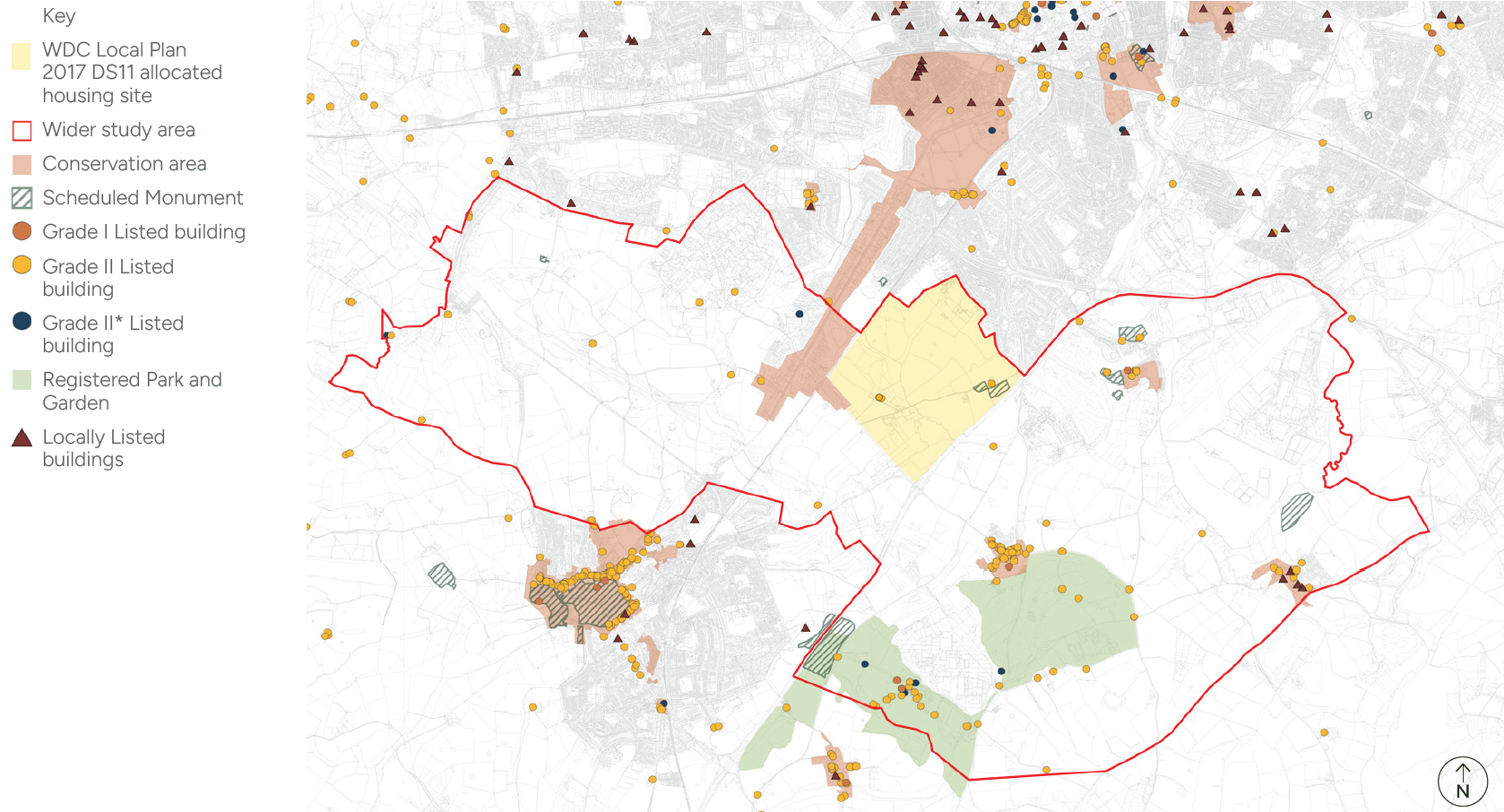
3.2 Heritage
King’s Hill, historically referred to as Hulle, King’s Hull, or Helen’s Hull, represents the remains of a deserted medieval village.
3.2.1 History and Origins
Archaeological evidence indicates that King’s Hill was associated with a monastic grange belonging to Stoneleigh Abbey and played a significant role in managing agricultural production for the Abbey’s estate. Pottery dating from the 13th to the 15th centuries confirms the medieval occupation.
3.2.2 Conservation Areas
Kenilworth Road Conservation Area is located to the west of the King’s Hill site boundary. It was first designated as a Conservation Area in 1968. This area is designated due to the existence of the mature spinney (small area of tree and bushes) that lines the length of the Kenilworth Road.
3.2.3 Designated Heritage Assets
There are three Grade II listed buildings and one scheduled monument within the allocated site boundary. The Wainbody Wood Farmhouse, Barn 16 Yards to East of Wainbody Wood Farmhouse and the Hill Farmhouse are Grade II listed.
The scheduled monument of the deserted medieval village at King’s Hill Lane survives relatively well as a series of earthworks, including up to eight rectangular building platforms, associated gardens, crofts, and trackways.
3.2.4 Non-Designated Heritage Assets
Assets and features identified through technical reports produced by Tetra Tech and Historic Environment Records (HERs):
- Prehistoric flint scatters
- Ring ditches and pits
- Romano-British settlements
- Field patterns and hedgerow
- Artefact scatters
- Medieval moated sites
- Fishponds
- Ridge and furrow
- Deserted villages at King’s Hill
- Post-medieval farmstead
- Quarries and industrial features.
Collectively, these non-designated assets provide evidence of past land use and settlement patterns. The allocated site itself contains no known non-designated assets or archaeological deposits of greater than low sensitivity, though there remains a possibility of unidentified features, most likely related to medieval and later agricultural activity such as field boundaries and plough soils.
In addition, non-designated buildings that positively contribute to the site's character showcase characterful features, such as red brick walls, gables, grey slate roofs, large front gardens and farmstead arrangements.
Heritage Key Considerations
- Safeguarding of Grade II listed structures and minimising the impact on the setting of structures, caused by new development.
- Protecting the setting with an appropriate offset and sensitive development
- Safeguarding land on and around the Scheduled Monument.
- Conservation area to inspire and provide design cues for built form.
- The character of rural typologies, such as cottages and farmstead buildings to provide design cues to inform built form, boundaries, setbacks, roofscape and layout.
- Complimentary materials to reflect local character.
3.2.5 History and Origins
Historically the surrounding area of King’s Hill Lane was rural farmland with scattered farmsteads. Major changes in the 20th century are influenced by transport and post war development.
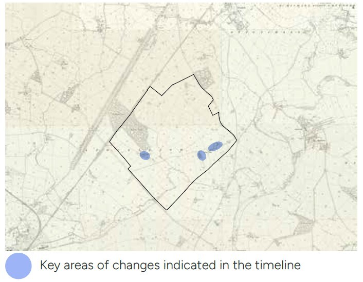
OS 25 Inch, 1892-1914
The landscape is dominated by open farmlands and hedged fields. Field boundaries are precisely surveyed, and King’s Hill exists as a rural track. There is no significant growth in built form except for a few expansions to farm buildings from previous decades. Early drainage ditches are visible within the landscape. The Coventry and Leamington branch of the train line remains a major landmark in the region.
OS 1937-1961
Early influence of growth within the infrastructure is evident through straightening and widening of roads for motor transport. Development on utility features for sewage and electricity is evident with growth in post war housing population. Loss of Stivichall Woods to accommodate housing shows a major change in the landscape character.

OS 1948-1975
Noticeable infrastructure growth with formalisation and expansion of roads connects expanding residential neighbourhoods. Landscape remains rural with expansion, due to the mechanisation of farms and farm access tracks. Major growth at the facilities and infrastructure of the water works site. Expansion from the direction of Kenilworth is apparent in the housing neighbourhoods.
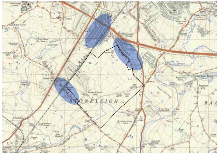
1880-1890s
Predominantly rural farmland, with visible medieval earthworks, including house platforms, ridge and furrow, and trackways associated with the deserted medieval village of King’s Hill
1900-1910s
By the turn of the century the historic landscape pattern persisted: fields, paddocks, and medieval earthworks still clearly visible. Minimal built expansion and a largely agricultural setting.
1900-1910s
By the turn of the century the historic landscape pattern persisted: fields, paddocks, and medieval earthworks still clearly visible. Minimal built expansion and a largely agricultural setting.
1940-1950s
Coventry saw major WWII changes, the King’s Hill Lane area’s historic records show no significant new features, and earthworks remained intact.
1960-1970s
Formalisation of road infrastructure and residential growth seen over the past decade, though significant suburbanisation, and Coventry’s broader post-war reconstruction.
1980-1990s
Archaeological monitoring continued. Infrastructure improved regionally, with Kenilworth Bypass opening in the 70s.
2000-2010s
Scheduled Monument status reinforced restrictions on development. King’s Hill nursery opens within the site, introducing new build form and land use. King’s Hill site allocated housing site within WDC Local Plan 2017.
2020s
Significant HS2 activities carried out in the region and improvements to the Kenilworth Bypass. Adopted SPDs guide the development, growth, and quality.
Figure 20 Historic Timeline of King’s Hill
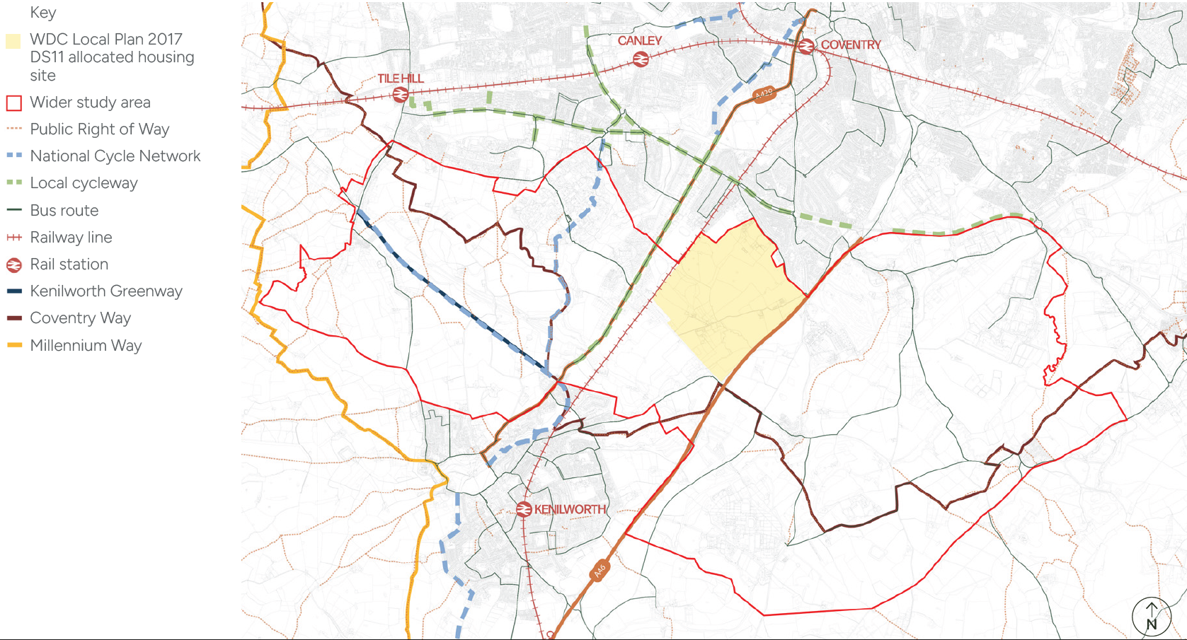
3.3 Movement
The site is well connected by road to a range of facilities, however, roads and railway lines currently sever pedestrian connectivity.
3.3.1 Pedestrian and cycling network
There are currently limited footways along Stoneleigh Road. King’s Hill Lane is the only publicly accessible route, it does not have a dedicated footway, and the shared carriageway is of variable width with no street lighting.
The closest segregated shared-use path to the allocated site is the local cycleway of Kenilworth Road and Kenpas Highway A45. The National Cycle Network route 52, situated to the west of the allocated site, locally connects the University of Warwick to Kenilworth.
The Coventry Way, a long-distance 40km walking route, loops around Coventry. It runs close to the south of the site and can be accessed close to the Stoneleigh Road and Kenilworth Bypass junction. Connectivity to the south is limited, an underpass exists to the south under the A46.
3.3.2 Street Hierarchy
The A46 is a 3 lane carriageway near the King’s Hill Lane junction, accommodating high volumes of traffic. It provides a direct connection between Coventry and Leamington. Stoneleigh Road Interchange provides access onto the A46 from the allocated site through Stoneleigh Road.
The A45 is a two-lane dual carriageway providing east-west connectivity between Coventry and Birmingham. St. Martins Road connects King’s Hill Lane to the A45. It is a single-carriageway road with a 40mph speed limit.
The local road network, primarily Stoneleigh Road/Gibbet Hill Road and Kenilworth Road/ Coventry Road corridor, provides alternative routes between Kenilworth, Leamington, Coventry, and the University of Warwick.
Green Lane, immediately north of the allocated site, is a single carriageway with access to major local facilities such as schools and a medical centre. The majority has a 20mph speed limit, which increases to 30mph to the south of Finham Park Primary School.
King’s Hill Lane runs east-west, within the allocated site, and is the existing primary access into the site. Two access points are located, one off Green Lane and another off Stoneleigh Road. It is a narrow, rural road with variable widths, it features existing drives to private properties.
3.3.3 Transport Accessibility
Rail - The Leamington Spa to Coventry line runs parallel to Kenilworth Road and adjacent to the allocated site boundary. The closest train stations to the site are Coventry and Kenilworth. The single-track line carries both passenger and freight line services.
Bus - The bus service operating along Green Lane is the closest facility serving the allocated site. Bus number 9 runs from Green Lane to the University Hospital Coventry via Coventry Station. The majority of the allocated site is not covered under 400m of a bus stop catchment area, and alternative active travel options could be introduced.
Movement Key Considerations
Potential to improve:
- Footpaths and cycle routes, including footpaths along Stoneleigh Road.
- Pedestrian crossings surrounding the site.
- Connectivity to the university.
- Access junctions from Green Lane and Stoneleigh Road.
- Connect to the existing bus network.
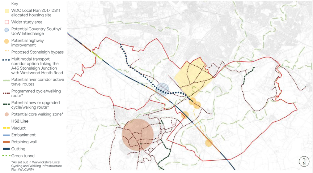
3.4 Future Infrastructure Plans
It is essential to understand the future infrastructure plans surrounding the site, to ensure the masterplan at King’s Hill Lane aligns with its future ambitions and plans.
3.4.1 Future Infrastructure Plans
The most important feature with respect to the allocated site is the programmed cycle and walking routes, set out within the Warwickshire Local Cycling and Walking Infrastructure Plan (WLCWIP).
The outline application features proposals for King’s Hill Lane, which includes a new or upgraded footway and cycle track adjacent to the road, and a path/cycle track through open space and crossing. A potential river corridor will feature active travel routes that follow Finham Brook towards the south of the allocated site, which would improve active travel through the site and wider area.
3.4.2 Road
A major ongoing improvement scheme is planned at the Stoneleigh junction to form a signalised gyratory layout with a two-bridge roundabout, which will have a direct impact on the visibility and traffic movement around the allocated site. Proposals for the multimodal transport corridor option, linking the A46 Stoneleigh Junction with Westwood Heath Road, will alleviate pressure on the A45 and are under consultation. These are critical local road congestion issues and insufficient provision for alternative modes of transport (active and public transport infrastructure) within the Westwood Heath and Gibbet Hill areas of south Coventry. Building on work undertaken by Warwickshire County Council, there is potential to deliver a multimodal transport corridor linking Westwood Heath Road to the A46 Stoneleigh Junction (with preference for active and public transport infrastructure to be strongly prioritised). Such a corridor could unlock longer term growth opportunities for the University of Warwick and provide additional connectivity for sites like King’s Hill Lane, and other potential growth locations allocated through the South Warwickshire Local Plan. It is important therefore that the masterplan accounts for such future opportunities.
3.4.3 HS2
Potential highway improvements have been identified in connection with the ongoing construction of HS2 rail line. The current works include the delivery of a new bridge over the carriageway, situated south of the Stoneleigh Interchange, to accommodate the future HS2 rail line. This represents the nearest point of intervention, which is located approximately 1 km south of the allocated site.
3.4.4 Heavy Rail/Very Light Rail
The heavy rail plans at Warwick Stoneleigh Road, transport interchange, involve the construction of a major compound along the A46 near Stoneleigh, expected to be completed by 2028. There is an aspiration to deliver bus-based park and ride, very light rail connectivity, with additional potential to deliver an interchange for active travel.
Future Infrastructure
Key considerations
- Potential for pedestrian crossings along Stoneleigh Road to connect to CVLR interchange and HS2.
- The potential to provide a new footbridge over the railway bridge to the north, towards the university, could influence plans for improvements for Stoneleigh Road.
- Potential to provide a river active travel route alongside Finham Brook.
- Potential to review King’s Hill Lane widening for vehicle access, to protect as many hedges and trees as possible and to protect the rural character of the lane.
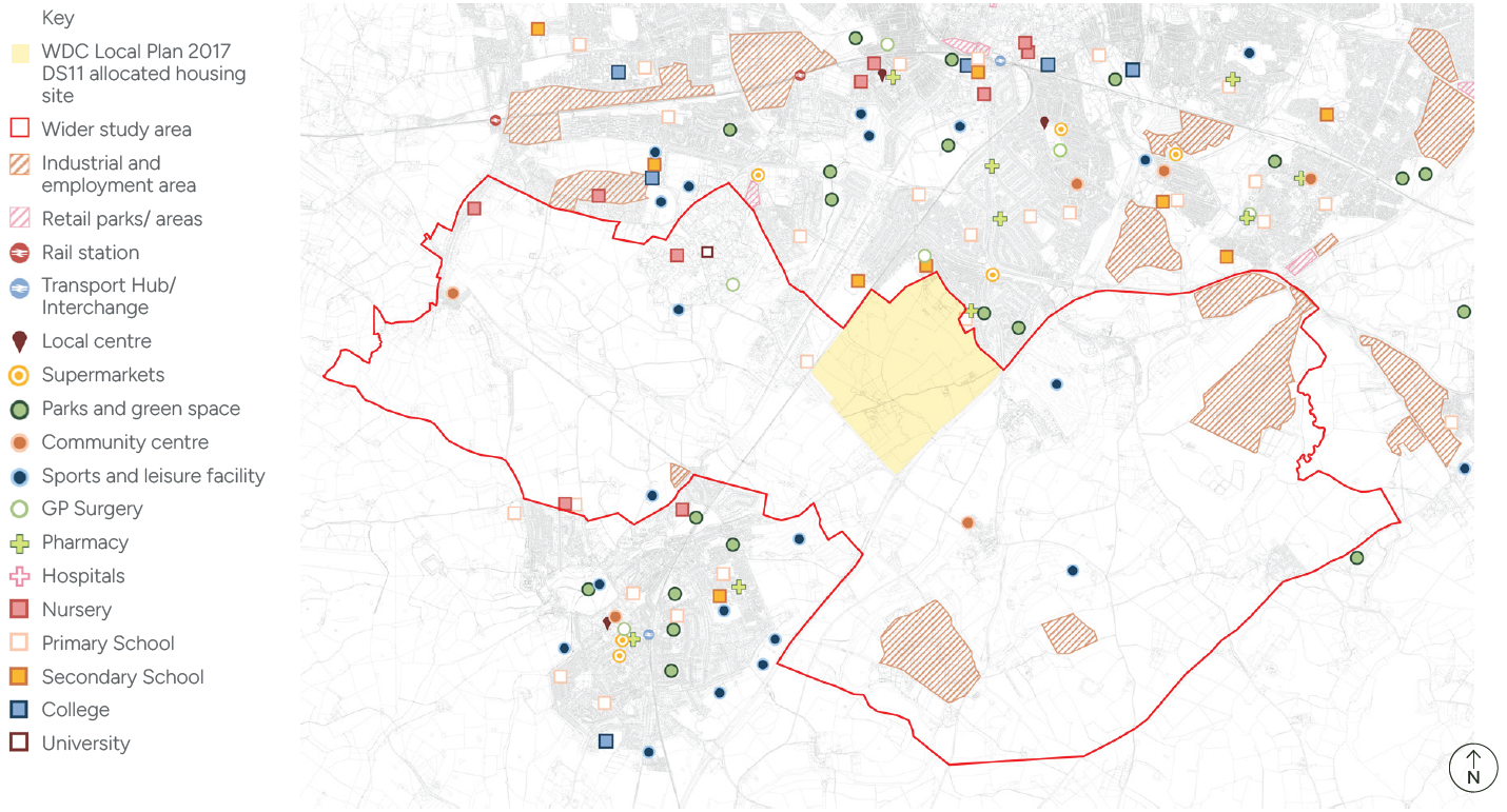
3.5 Land Use and Local Amenities
The site is predominantly agricultural fields and buildings, with several dwellings situated along King’s Hill Lane.
Leasowes Garden Nursery, King’s Hill Lane Nurseries, a small commercial building, Hazel Tree Barns, with a salon and Senior Care offices are situated within the allocation boundary.
3.5.1 Local Amenities
The closest location of local services is a parade of shops with a convenience store, post office, chemist and takeaway on Green Lane. Further along St Martin’s Road towards Stivichall roundabout, there is a Premier Inn, a steakhouse and a BP petrol station with electric charging points within 500m from the allocated site boundary. Other local amenities include:
- Green Lane Medical Centre is located to the northern edge of the allocated site.
- Finham library is within a 10-minute walk from the King’s Hill Lane access point through Green Lane
- King’s Hill nursery and Alf’s Cafe are located within the allocated site on the King’s Hill Lane.
- The nearest supermarkets are within a 10-minute drive, including Asda at Daventry Road and the Aldi and Tesco Superstore at Cannon Park Shopping Centre.
3.5.2 Education
Finham Primary School and Finham Park Secondary School are located on Green Lane, adjoining the northern and eastern boundaries of the site. In addition, eight other primary schools are located within 3km of the site. Bishop Ullathorne Catholic Secondary School is located within 2km of the site. Whitley Academy and Kenilworth School and Sixth Form are located within 4km of the allocated site.
3.5.3 Open Space, Play and Recreation
The Alvis Sports and Social Club and playing field are located to the east of the site, along Green Lane. Finham Green and The Field are the closest open green spaces, there are no equipped play facilities in these spaces.
3.5.4 Open Space
There are no designated parks or gardens within the allocated site, due to the nature of the site, containing open agricultural fields. Residents from the local area may likely use parts of the site informally for walking and dog walking. In the area north of Finham Primary School, desire lines can be seen in the field parcel.
There are several open spaces in the area, including:
- Wainbody Wood is within the allocation boundary but is within private land ownership and is not accessible.
- The War Memorial Park in Cheylesmore (approx. 20-minute walk from the northern edge of the site).
- The Vale in Cannon Park is approximately a 30-minutes’ walk from the northern edge of the site.
- Tocil and Gibbet Hill Wood is approximately a 25-minute walk from the southern edge of the site.
Land Use and Amenities Key Considerations
- Enhance connections to surrounding local facilities.
- Potential for new community facilities and schools.
- New accessible play parks to benefit the new and existing community.
- There is a deficit of sports facilities such as 3G pitches, Rugby Pitches, in the local area. There is an opportunity to provide these sports facilities within the masterplan.
- Opportunity to provide senior living accommodation to ensure intergenerational living options.
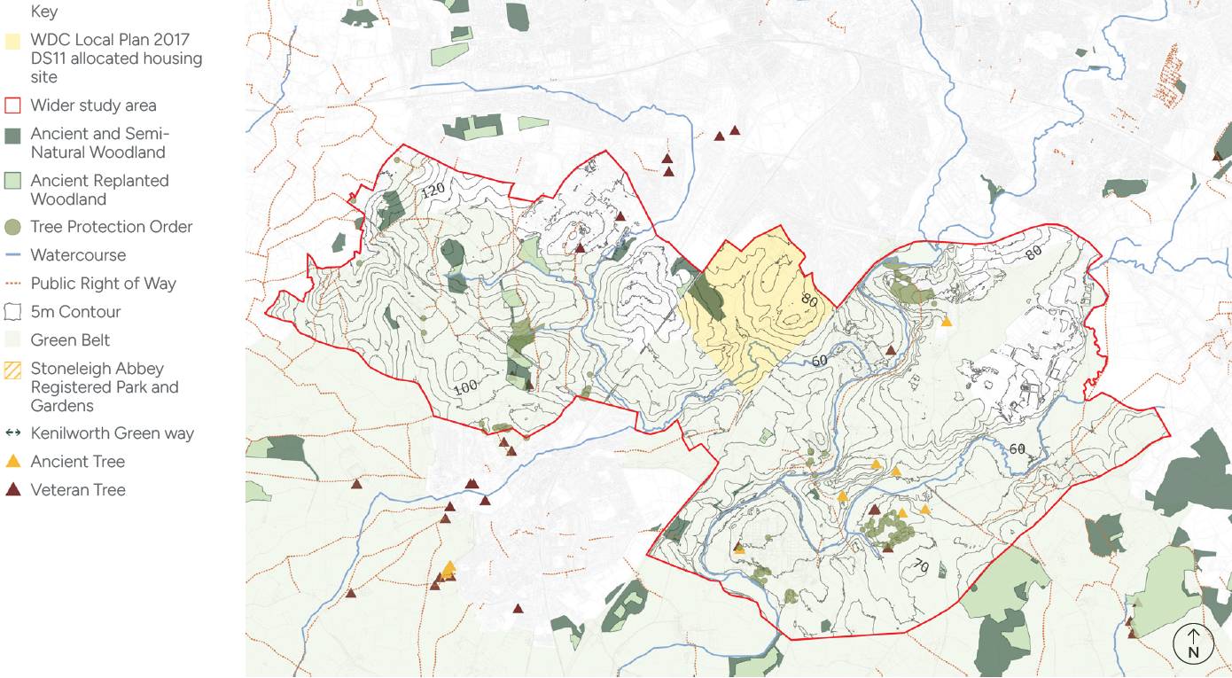
3.6 Landscape
3.6.1 Landscape
The site and surrounding landscapes to the northwest and south, lie within the Arden Parklands Landscape Type, defined by the Warwickshire Landscape Guidelines (November 1993).
The site is broadly consistent with the overall character and qualities of an enclosed, gently rolling landscape defined by woodland edges, parkland and belts of trees. However, the roads, railway and Coventry settlement also exert urbanising influences on the site and modify local tranquillity.
In February 2016, WDC published a report on the sustainable landscape planning of future urban expansion options. This highlights the potential to retain significant landscape elements and green space within development on the site, supporting a successful transition from urban to rural areas. Further landscape considerations, important to creating distinctive character and strong identity in the masterplan, are the integration of the principal drainage pattern into a network of multifunctional green infrastructure; ensuring ecological corridor linkages by retaining woodland with landscape buffer zones, within greenspace networks; the integration of landscape assets such as ponds, tree and hedgerows; allowing topography to inform distinctive and unique spatial design, with sensitive development around King’s Hill; creating landscape buffers adjacent to busy roads; providing a range of connected open spaces; and integrating native hedge planting, hedge trees, small copses and riverine habitats.
Landscape Character Key Considerations
- Create distinctive character and strong identity in the masterplan.
- Integration of the principal drainage pattern into a network of multifunctional green infrastructure.
- Ensuring ecological corridor linkages by retaining woodland with landscape buffer zones, within greenspace network.
- Integration of landscape assets such as ponds, tree and hedgerows.
- Topography to inform distinctive and unique spatial design, with sensitive development around King’s Hill.
- Landscape buffers adjacent to busy roads.
- Provision of a range of connected open spaces.
- Integration of native hedge planting, hedge trees, small copses and riverine habitats.
3.6.2 Landscape and Visual Impact
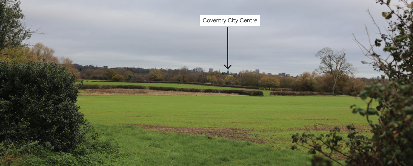
The landscape and visual impact assessment (LVIA) prepared as part of the Environmental Statement for the King’s Hill Lane Park Outline Planning Application (W/188/0643) sets out the character of the site in detail. This describes intervisibility from elevated slopes in the site, with the settlement, including the spires of Coventry Cathedral, and with the wider rural landscapes to the south. The site’s fields are enclosed by hedgerows with some hedgerow trees. A few hedgerows across King’s Hill are species rich. Finham Brook is lined by small areas of woodland and has a strong sense of place.
A number of ponds surrounded by vegetation are also present around the site. Existing built form on the site includes farm buildings and cottages, including two listed buildings, mainly focused along the hedge-lined single track. The scheduled monument is not marked although areas of ridge and furrow are visible here. This, and the properties contribute to the time depth and sense of place of the site.
The LVIA shows that views toward the site from the northwest and northeast, are limited by the existing neighbouring settlement. To the southwest and southeast, landform limits potential visibility of the site to around 2km distance. Zone of Theoretical Visibility (ZTV) drawings were also prepared for development on the application site, and for additional development in the north and south. There are limited differences in the ZTV for the application development alone compared with the additional development areas to the north and south. All ZTVs show that the main areas from which the development would be visible are within the site itself, and from surrounding undeveloped areas up to 1km, to the northwest and south. Between 1km and 2km distance, the ZTV show reduced areas of potential visibility of the application development and additional developments.
The LVIA concluded no significant residual landscape effects beyond the site itself, and significant effects for a limited number of visual receptors within and surrounding the site. This is based on the existing settlement edge context to the site, and visual containment by topography and vegetation. The LVIA notes that many new areas of planting throughout the scheme combined with retained vegetation, would mitigate the landscape and visual effects with time. However, the avoidance and mitigation of notable landscape and visual effects will remain important considerations in the detailed designs for built form and landscape areas of the scheme.
Landscape and Visual Impact Key Considerations
- The masterplan design should respond positively to the baseline landscape character, a requirement of meeting Policy NE4 of the WDC Adopted Local Plan.
- Development to the northwest and northeast should respond to the existing settlement edge.
- Development to the southwest should respond to the enclosed character and well-treed valley side, as well as the conservation area and adjacent Green Belt.
- Development at King’s Hill responding sensitively to its greater visibility from the rural areas to the east.
- A sensitive response is required to the Finham Brook, and retention of green infrastructure along it, linking across the site.
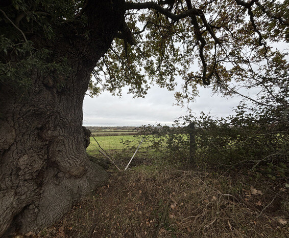
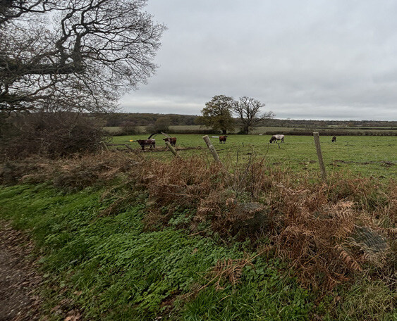
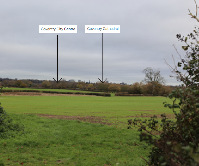
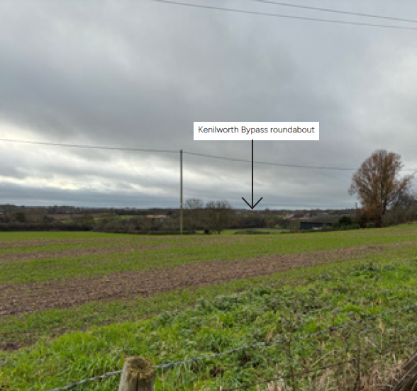
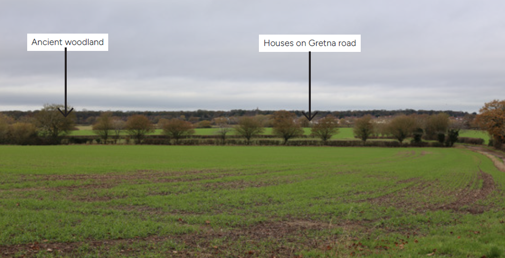
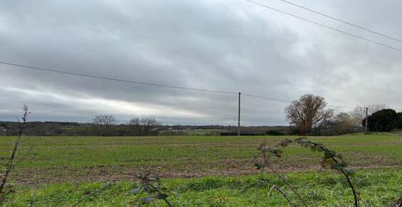
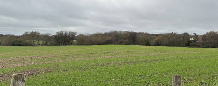
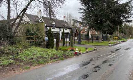
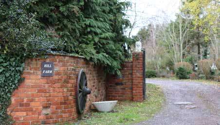
Figure 25 Photographs show various views from King’s Hill Lane
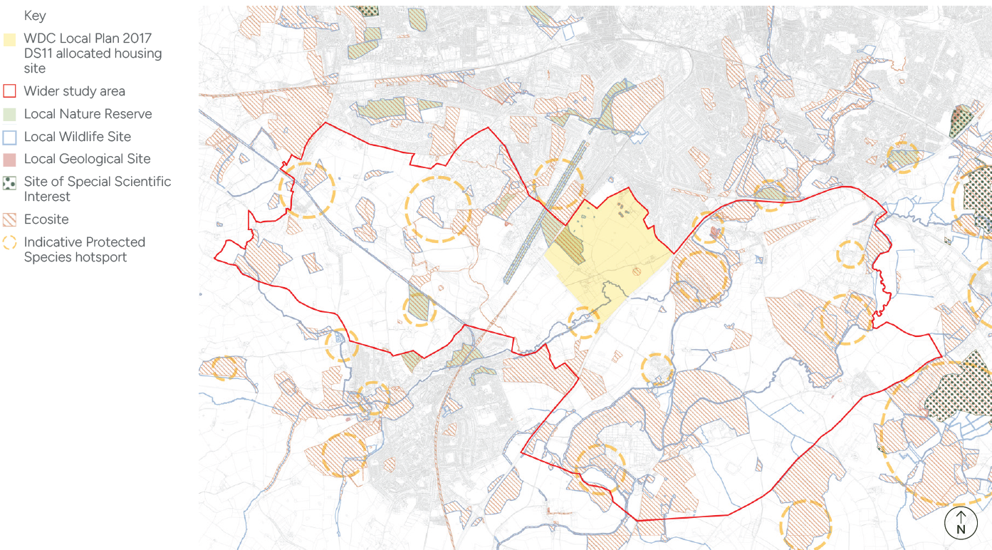
3.7 Nature
King’s Hill Lane is defined by a strong network of natural assets, with Wainbody Wood and Finham Brook forming the ecological backbone of the site.
These assets are supported by a mosaic of hedgerows, mature trees, waterbodies, and grasslands, providing habitat connectivity and biodiversity value across the wider landscape. Figure 26 illustrates the sites existing nature assets.
3.7.1 Ecology
Local Wildlife Site (LWS) designated as ‘Wainbody Wood & Stivichall Common, Kenilworth Road Spinney’ LNR, also designated as ‘Wainbody and Kenilworth Road Woods’ Local Wildlife Site (LWS) is listed in English Nature’s Ancient Woodland Inventory.
The site features mixed broadleaved ancient semi-natural woodland (Wainbody Wood), bisected by the railway. It has a variety of trees and a well-established shrub layer present in most places. In the northern part of the woodland, drainage is impeded, resulting in invaluable wet wood conditions. A variety of invertebrates, fungi and birds were recorded.
3.7.2 Habitats
Identified Important ecological features within the allocated site are marshy grassland, scattered mature trees, hedgerows, and trees, broadleaved semi-natural woodland, watercourses (Finham Brook), bird assemblage, bat assemblage, otters, badgers, and Great Crested Newts.
There are various notable wildlife habitats throughout the area.
3.7.3 Watercourse
Finham Brook is an important wildlife corridor featuring various habitats, including improved and semi-improved grasslands and tall herbs. Several veteran trees are present on the brook bank.
Nature Key Considerations
- 50m buffer and offset surrounding Local Wildlife Site (LWS) Wainbody Wood.
- 15m easement around Finham Brook.
- Enhancements to ecological corridors, connections to wider ecology network.
- Repair and gapping up of hedgerows.
- Easements from TPOs, hedgerows and tree groups.
- Easement from Finham Brook and dry ditch
- Protection of habitats within the site.
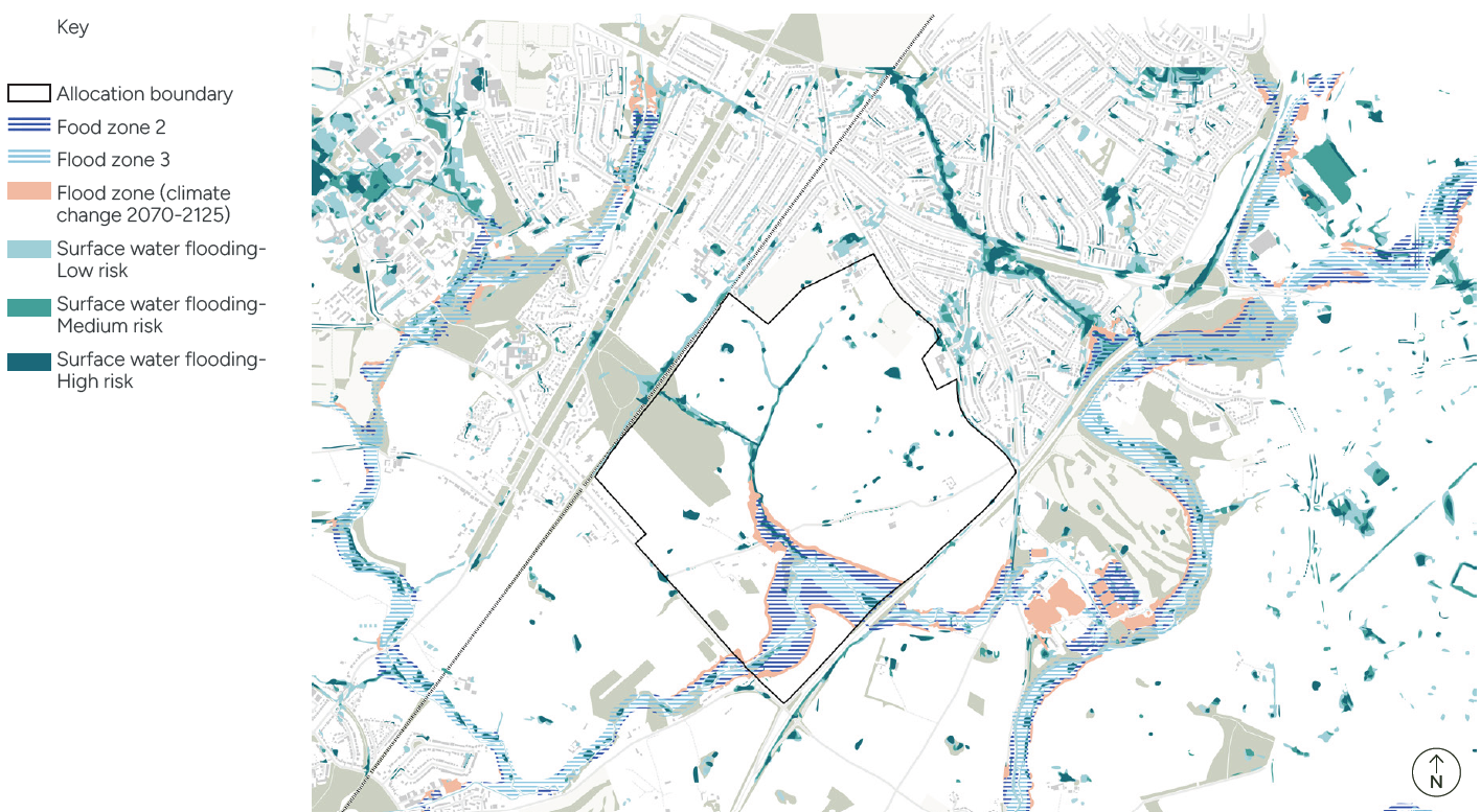
3.8 Hydrology
Elevations on the site slope down to the Finham Brook, a designated ‘Main River’ and main hydrological feature of the area.
A tributary of the Finham Brook, referred to as the Finham Brook Tributary, runs through much of the northern portion of the site. During storm conditions, surface water flows would follow topographic direction and flow towards the Finham Brook or its tributary.
The flood risk from a range of sources, including fluvial and surface water, needs to be considered and addressed through the masterplan.
3.8.1 Flood Risk and Waterways
The Finham Brook and its tributary are the most significant watercourse features within the allocated site. Finham Brook, a tributary of River Sowe, flows in a general north-easterly direction before discharging into the River Sowe at the Severn Trent Water Finham Sewage Treatment Works. Additionally, there is a series of small ponds located across the Application Site.
The risk of fluvial flooding across most of the study area is low. However, areas adjacent to the Finham Brook have been designated as Flood 2 and 3. A flood model for the Finham Brook and its tributary demonstrates flood risk along the tributary under design conditions (i.e. including climate change). Development, including the placement of SuDS, would not be permitted within these high-risk areas.
The risk of surface water flooding across most of the site is considered very low. However, there are several high-risk surface water flow pathways through the site, which should be set as open space within the scheme.
There is a 1350mm diameter combined sewer that runs across the allocated site, which is fed by a 675mm diameter combined sewer on the western side of the Application Site and a 375mm diameter foul water on the eastern side of the Application Site. While these are unlikely to result in significant flooding, buildings should not be located over or within a 3m easement to either side of these features, or, subject to agreement, these features could be diverted along roads or other open corridors within the scheme.
Other sources of flooding, including tidal, groundwater and infrastructure failure, are low risk.
Hydrology Key Considerations
- Appropriate easement along Finham Brook and along the Finham Brook Tributary.
- Flood compensation to accommodate new bridges over the Finham Brook and its tributary.
- Accommodation of existing surface water flow pathways through the site
- Adequate space for SuDS outside of areas of fluvial flood risk
- Integration of SuDS at both plot and site-wide scales, considering the amenity and biodiversity benefits.
- Development proposals, including play areas, to avoid building over existing sewers easements.