Proposed Modifications January 2016
Appendix 1
Table of Proposed Modifications to the Publication Draft Local Plan (Part 1)
(to address identified issues of soundness)
January 2016
About these proposed modifications
The proposed modifications to the Publication Draft shown in the table below have been prepared in February 2016 to specifically address the issues of soundness identified by the Inspector set out in his letter of 1st June 2015. The proposed modifications are based on the text of the Publication Draft Local Plan published in April 2014 as amended by the Focused Consultation published in October 2014.
A number of other amendments have been proposed in response to the consultations undertaken in May/June 2014 and November/December 2014. These have been shown in full in submission documents LP23 and LP23a. However, these amendments have not yet been subject to consultation and do not form part of current considerations. It is anticipated, subject to the agreement of the Local Plan Inspector, that any of these amendments that are substantive in nature, will form part of a future consultation following Examination hearings prior to finalising and adopting the Local Plan.
Note: In the table below,
new text is shown as follows: INSERTED:
existing text to be deleted is shown as follows: DELETED:
| Ref | Publication Draft Local Plan Page number | Paragraph Number | Proposed Modification | Reason | ||||||||||||||||||
|---|---|---|---|---|---|---|---|---|---|---|---|---|---|---|---|---|---|---|---|---|---|---|
(35) Mod 1 |
14/15 |
Policy DS2 |
Amend Policy DS2 to read STRATEGIC POLICY DS2: Providing the Homes the District Needs We will provide in full for the Objectively Assessed Housing Need of the District INSERTED: and for unmet housing need arising from outside the District where this has been agreed. We will ensure new housing delivers the quality and mix of homes needed including
|
To reflect the Coventry and Warwick Housing Requirements MoU |
||||||||||||||||||
(15) Mod 2 |
15 |
Para 2.6 |
Amend para 2.6 to read National policy requires local planning authorities to boost significantly, housing supply. A key element in this is developing an evidence base to objectively assess housing need and ensuring that this Objectively Assessed Need is met in full for both market and affordable housing INSERTED: in the housing market area. This means that all the Councils within the Housing Market Area need to work together, in line with the Duty to Co-operate, to ensure the housing need is met in full. This in turn means that the Council needs to play its part in meeting unmet housing need arising from outside the District. In this respect, the Council is party to a Memorandum of Understanding, agreed in October 2015, to accommodate some of Coventry's housing need within the District. National policy also emphasises the importance of delivering a wide choice of homes by planning for a mix of housing based on current and future demographic and market trends. The Council has undertaken a Joint Strategic Housing Market assessment with the other local authorities in the Coventry and Warwickshire Sub-region. This provides the basis for establishing the District's Objectively Assessed Need |
To clarify amendment to Policy DS2 |
||||||||||||||||||
(55) Mod 3 |
16 |
Policy DS4 |
Amend Policy DS4 to read: STRATEGIC POLICY DS4: Spatial Strategy Allocated Housing and Employment will be distributed across the District to take account of the following: ….
.... |
To clarify clause b) and to align with proposed amendments arising from consultation undertaken in May/June 2014 and to provide a clear strategic basis for the proposed site allocations |
||||||||||||||||||
(33) Mod 4 |
18 |
Policy DS6 |
Amend Policy DS6 to read: POLICY DS6: Level of Housing Growth The Council will provide for INSERTED: 16,776 DELETED: 12.860 new homes between 2011 and 2029 |
To align with updated housing needs evidence and with the Coventry and Warwickshire Memorandum of Understanding for Housing Requirements |
||||||||||||||||||
(23) Mod 5 |
18 |
2.20 |
Delete para 2.20 and replace with: INSERTED:
The Updated Assessment of Housing Need: Coventry-Warwickshire HMA (September 2015) sets out the objectively assessed future housing needs of the Housing Market Area and the six local authority areas within it. The report indicates that Warwick District's Objectively Assessed Housing Need is 600 dwellings per annum, which equates to 10,800 dwellings over the plan period. However, in recognition that Coventry City Council is unable to accommodate its housing needs in full within the City boundary, the Local Plan seeks to provide for 332 dwellings per annum (5976 over the plan period) towards Coventry's housing needs. Warwick District therefore aims to meet its housing requirement by providing for a minimum of 16,776 new homes between 2011 and 2029. |
To clearly explain the reasoning for the proposed level of housing growth |
||||||||||||||||||
(33) Mod 6 |
18/19 |
Policy DS7 |
Amend Policy DS7 to read:
|
To update the proposed sources of supply to achieve the modified housing requirement set out in the amendments to Policy DS6. In particular to a) reflect the most recent data on completions and permissions and b) set out a revised windfalls allowance to reflect revised assumptions in line with the Inspector's findings. c) Update SHLAA site based on 2015 call for sites d) Revise allocations based on updates |
||||||||||||||||||
(16) Mod 7 |
19 |
2.21 to 2.24 |
Amend para 2.21 to 2.24 to read 2.21 The Council's approach to identifying land for housing is set out in the Spatial Strategy above. DELETED: Taking account of completions, committed sites and an allowance for windfall sites, the Council needs to identify sites for an additional 6,746 new homes. INSERTED: In the context of completions since 2011, committed sites, an allowance for windfall sites and small urban SHLAA sites, the plan identifies sites for a potential 9,369 homes. This allows for an element of flexibility in the event that some sites fail to come forward or are delivered with reduced capacities than that allowed for in the plan 2.22 In addition to completions and commitments, the Council has made an assessment of windfall sites which are likely to emerge based on past trends and taking into account likely changes to those trends. Windfall sites have consistently played an important role in the housing supply of the District DELETED: Between 2002 and 2013 the averaged 191 units a year (including garden land development), even with 3.5 years of a housing moratorium. 2.23 The identified sites include small urban brownfield sites of between 5 and 50 dwellings which are assessed as being suitable and available for development in the Strategic Housing Land Availability Assessment. The balance of housing is provided on allocated brownfield and greenfield sites across the District, based on the priorities set out in the spatial strategy. 2.24 The following Housing Trajectory shows the timeline for the delivery of housing across the plan period in relation to the annual average of the total requirement. Amended Housing Trajectory Graph is shown in Appendix A below |
To clearly explain the sources of supply proposed in the modifications to Policy DS7 and to set out the revised timeline for the delivery of housing across the plan period |
||||||||||||||||||
(31) Mod 8 |
24/25 |
Policy DS10 |
Amend Policy DS10 to read
|
To reflect proposed revised distribution of housing in line with Policy DS4 |
||||||||||||||||||
(20) Mod 9 |
23 |
2.37 and 2.38 |
Amend paras 2.37 and 2.38 to read 2.37 The spatial strategy aims to meet housing needs of the District and the Housing Market Area by allocating sites INSERTED: in and adjacent to the main urban areas and the more sustainable villages. The Strategic Housing Land Availability Assessment identifies suitable and available sites DELETED: across the four towns and adjacent to villages. In line with the Council's aim of meeting housing needs in sustainable locations, the site selection exercise favoured sites firstly within the urban areas and then on the edge of urban areas. These locations are well placed to make best use of, and improve, the existing transport infrastructure and accessibility to jobs and services. Sites on the edge of urban areas are of sufficient size to deliver supporting services including schools, GP services and local centres as appropriate. 2.38 In selecting sites on the edge of urban areas, non-Green Belt sites are favoured over Green Belt sites where possible. However, where there are no suitable non-Green Belt alternatives INSERTED: to meet an identified need, sites are removed from the Green Belt to enable development to take place. This applies to land to meet the needs of INSERTED: Coventry, Leamington, Kenilworth, some of the villages and land on the edge of Lillington to assist in the regeneration of the area. |
To explain amendments to Policy DS10, in particular making reference to meeting Coventry's needs |
||||||||||||||||||
Mod 10 |
24/25/26 |
Policy DS11 |
Amend Policy DS11 as shown in Appendix B of this schedule of modifications |
To identify sufficient specific allocated sites to address unmet need arising in Coventry and the reduced windfalls allowance |
||||||||||||||||||
(31) Mod 11 |
26/27/28 |
2.41 to 2.53 |
Amend paras 2.41 to 2.53 as shown in Appendix B of this schedule of modifications |
To reflect changes to Policy DS11 and to explain the rationale behind the proposed additional sites |
||||||||||||||||||
(4) Mod 12 |
28 |
Policy DS12 |
Amend Policy DS12 to read DS12 Allocation of Land for Education Land at Southcrest Farm, Kenilworth (ED2) and land at Myton (ED1), as shown on the Policies Map, is allocated for educational uses and other compatible uses (see policy HS5). This includes, on each site, the provision of a secondary school, 6th form centre and, INSERTED: if deemed the most appropriate location, a primary school. INSERTED:
In the case of Southcrest Farm the whole area of the site is unlikely to be required for educational purposes. Any land within this site that is surplus to the educational requirement is therefore allocated for housing (see Policy DS11) |
To reflect proposals to allocate Southcrest Farm for housing as well as education as set out in Policy DS11 |
||||||||||||||||||
(5) Mod 13 |
28 |
Para 2.56 |
Amend para 2.56 as follows: 2.56 Kenilworth Secondary School and 6th Form: the existing school sites are allocated for housing within Policy DS11. The school is seeking to locate all its facilities on a single site. Further, the additional housing proposed in the Kenilworth priority area means that the school needs additional capacity if it is to continue to DELETED: offer the educational choice it currently provides INSERTED: provide for the educational needs of the Town and surrounding area. For these reasons, a new site for a secondary school in Kenilworth is required. In addition, the additional housing allocated in the Kenilworth area requires the provision of a new primary school. Over and above the educational INSERTED: land requirement, the site has capacity for housing, as set out in Policy DS11. The land at Southcrest Farm, as shown on the Policies Map, is therefore allocated DELETED: for INSERTED: primarily for educational purposes and other compatible uses as defined by policy HS5 INSERTED:, and for housing where there is surplus land over and above the educational requirement. |
To reflect proposals to allocate Southcrest Farm for housing as well as education as set out in Policy DS11 |
||||||||||||||||||
(276) Mod 14 |
30/31 |
Policy DS15 |
Amend Policy DS15 to read: DS15 Comprehensive Development of Strategic Sites The sites to which this policy applies are (as shown on the Policies Map):
Proposals for DELETED: all or part of the allocated INSERTED: strategic sites DELETED: detailed above will be approved where they INSERTED: represent a comprehensive development scheme for the whole site.DELETED: The comprehensive development scheme will take INSERTED: There will be a requirement to demonstrate this by the submission DELETED: in the form of either a Development Brief or a DELETED: Masterplan INSERTED: Layout and Design Statement as appropriate, to be approved by the Local Planning Authority INSERTED: (Policy BE2, paragraph 5.13). The Development Brief or DELETED: Masterplan INSERTED: Layout and Design Statement should address the criteria set out in Policy BE2 and, for the sites set out below, should provide for the delivery of infrastructure and services, which as a minimum should include the following:
The Development Brief INSERTED: s for
INSERTED: should be broadly compatible with each other, in their approach to development issues, provision of linked infrastructure and commitment to sustainable growth. |
To ensure the policy reflects the additional strategic allocations set out in policy DS11 |
||||||||||||||||||
(13) Mod 15 |
31 |
2.66 to 2.68 |
Amend paras 2.66 to 2.68 Explanation 2.66 The sites listed within this policy are the allocated strategic urban extensions. A number of these sites are in multiple ownerships. This policy seeks to ensure that development on these sites comes forward within the context of an appropriate INSERTED: and comprehensive INSERTED: development scheme. The Development Brief INSERTED:/ Layout and Design Statement should clearly demonstrate how the mix of uses and the infrastructure requirements set out in policy DS7 (and articulated further within the Policies Map and Infrastructure Delivery Plan) will be planned for and delivered to ensure the development is sustainable and meets the policies set out elsewhere in this Local Plan. INSERTED: To ensure the most sustainable and deliverable form of development is achieved on these significant sites, landowners are strongly encouraged to work together closely to produce the most appropriate overall scheme for the site. This might for example be achieved through the setting up of consortia or other formal means of co-ordinated joint working (including the local planning authority as a full partner). 2.67 Without a comprehensive development scheme, the delivery of infrastructure and services (such as schools, open space, roads, transport facilities, community facilities and local centres) cannot be guaranteed or properly integrated into the area. Further, incremental proposals which do not take sufficient account of proposals for the whole site are less likely to deliver a high quality, integrated development which can build a strong sense of place and sustainable neighbourhoods. 2.68 The INSERTED: strategic sites DELETED: at West of Europa Way and South of Harbury Lane will be required to be developed in a comprehensive manner whereby the proposals for one take account of the other. This will further ensure integrated development, efficient use of land and access to high quality infrastructure and services across the DELETED: two sites. |
|||||||||||||||||||
(368) Mod 16 |
35 |
2.81 |
Amend para 2.81 to read: Land has been removed from the Green Belt at: DELETED:
INSERTED:
|
To reflect green belt allocations and proposed safeguarded area identified in amendments to the Policy DS11 and Policy DSNew2 |
||||||||||||||||||
Policy DS20 DELETED: Accommodating Housing Need Arising from Outside the District INSERTED: Review of the Local Plan |
||||||||||||||||||||||
(20) Mod 17 |
36 |
Delete existing Policy DS20 and replace with: INSERTED:
The Plan will be reviewed (either wholly or partially) prior to the end of the Plan Period in the event of one or more of the following circumstances arising: -
|
To reflect the issues raised by the Inspector with regard to Plan Review, which renders the current policy DS20 unsound. A more broadly based Plan review policy is however still appropriate to provide an effective approach to managing risks associated the larger strategic sites and future growth pressures within the HMA |
|||||||||||||||||||
(12) Mod 18 |
36 |
2.82 to 2.87 |
Replace paras 2.82 to 2.87 with the following: INSERTED:
2.82 In the event that the Plan as a whole or a key part of it becomes out of date, it will be necessary to undertake a full or partial review of the Plan. There are a number of factors that could render the Plan out of date:
2.83 Policy DS NEW1 indicates that a partial review of the Local Plan will be undertaken within five years of the adoption of the plan, to address specific circumstances in the area to the south of Coventry. This proposed partial review will be undertaken in any event. |
To reflect the MoU |
||||||||||||||||||
(2) Mod 19 |
Maps |
Policies Map |
Amend the Policies Map as follows: Appendix C DELETED:
Allocate additional land for housing in line with Policy DS11 (see Appendix B below) in the following locations:
Amend the Urban Area Boundary in the following locations:
Amend the Growth Village Envelopes in the following locations:
Remove allocated land for housing in line with Policy DS11 (see Appendix B below) in the following locations:
Amend Policies Map to allocate additional land for Education in line with Policy DS12 in the following location
Amend the Policies Map to extend the Park and Ride area of search in the following location
Amend Policies Map to remove additional land from the Green Belt in line with Policy DS19 in the following locations
Amend Policies Map to remove land from the Green Belt and safeguard it in line with Policy DS NEW2 in the following locations
Amend Policies Map to identify the masterplan area for the development of the former Police HQ sites at Woodcote House, Leek Wootton in line with Policy DS NEW3 (policies Map 12) Amend Policies Map to allocate land for outdoor sports in line with Policy DS NEW4 in the following locations
INSERTED:
Allocate additional land for housing in line with Policy DS11 (see Appendix B below) in the following locations:
Amend the Urban Area Boundary in the following locations:
Amend the Growth Village Envelopes in the following locations:
Remove allocated land for housing in line with Policy DS11 (see Appendix B below) in the following locations:
Amend Policies Map to allocate additional land for Education in line with Policy DS12 in the following location
Amend the Policies Map to extend the Park and Ride area of search in the following location
Amend Policies Map to remove additional land from the Green Belt in line with Policy DS19 in the following locations
Amend Policies Map to remove land from the Green Belt and safeguard it in line with Policy DS NEW2 in the following locations
Amend Policies Map to identify the masterplan area for the development of the former Police HQ sites at Woodcote House, Leek Wootton in line with Policy DS NEW3 (policies Map 12) Amend Policies Map to allocate land for outdoor sports in line with Policy DS NEW4 in the following locations
|
To reflect amendments to policies DS11, DS12, DS19, and addition of policies DS NEW2, DS NEW3, DS NEW4 |
||||||||||||||||||
(36) Mod 20 |
New |
DS New1 |
New policy wording: INSERTED:
To meet both local and sub-regional housing needs, the Council has identified an area of growth focussed on strategic housing allocations to the immediate south of the City of Coventry (see policy DS11). The geographic boundaries of the area covered by this policy will be guided by: -
The sites in this area are expected to provide residential-led, mixed-use development of around 2225 dwellings over the plan period to 2029, with the potential for additional growth post-2029:
To facilitate this growth, the Green Belt boundary in this area has been amended to take account of the strategic sites and to identify and safeguard land suitable for longer-term growth requirements (see Policies DS19 and DSNEW2). The Council intends to schedule a partial Plan review within five years of the adoption date of this Plan (see policy DS20). At that time, and subject to sufficiently robust evidence, the Council will consider whether further land is required within the broad area to allow for future growth. Development proposals must take account of all significant constraints, other development within the vicinity and future opportunities for integrated strategic growth; this will require close co-operation between WDC, Coventry City Council, Warwickshire County Council, the University of Warwick and major landowners and developers. It is likely that some of this development activity will extend beyond the current plan period. To give a degree of longer-term certainty to investors and stakeholders, a series of key objectives are identified below to provide clear guidance to landowners, institutions, infrastructure providers and major developers when they are drawing up their proposals.
Where appropriate, contributions to infrastructure provision will be sought in accordance with policy DM1. |
To provide a comprehensive approach to the planning of this area of growth including growth beyond the Plan Period |
||||||||||||||||||
(22) Mod 21 |
New |
New Paras New 1.1 to New 1.10 |
New explanatory text: INSERTED:
1.1 Part of the housing requirement set out in Policy DS6 seeks to meet Coventry's housing need. This is an important aspect of creating a sustainable and secure base for the growth of the city. The Warwick Local Plan has thus identified the need to deliver integrated, strategic development to meet current and future housing need both for its own requirements and to address the need generated by Coventry. 1.2 To do this, an area adjacent to the boundary with the city has been identified as a suitable prospect for delivering part of the housing required. This will help create opportunities for high-quality design and layout to be delivered via co-ordinated masterplans. It will allow for the generation of development that benefits from its proximity to the City's employment, education and services / facilities rovision in terms of travel times and infrastructure provision. 1.3 There will be the opportunity to generate economic benefits both through the provision of new employment opportunities and through the creation of additional residential populations that will be using extant services and facilities, so supporting their retention. There will also be the opportunity to deliver infrastructure improvements that should not only benefit the new development but, if properly designed and delivered in a timely fashion, may also help to alleviate existing problems on the local and strategic transport network. Sites can be linked to local and sub-regional centres through improvements to public transport, cycling and walking links. 1.4 The sites in this immediate area (including where necessary related sites within the boundary of the City of Coventry) will benefit from a shared set of key objectives. These are intended to set a clear framework for the delivery both of the development sites themselves and the associated large-scale infrastructure requirements, such as the link road. As described in the policy, the key objectives identify a number of broad parameters. Within these strategic parameters, developers and promoters are at liberty to provide their own detailed masterplans / design approaches that should be in accordance with the broader strategic principles. 1.5 The University of Warwick will prepare a revised masterplan within the Plan Period (see policy MS1). The potential growth of the University is an important element in the development of this area and needs to be taken into account in considering site layouts elsewhere in the vicinity and particularly in planning for wider infrastructure. This will ensure the area has capacity to address development that is not currently known about but which is likely to come forward within the Plan Period and during the years immediately afterwards. 1.6 At Westwood Heath an area of c30ha has been identified for a residential-led, mixed-use development (see Policy Map). Given infrastructure constraints, especially along the strategic and local highways network, the housing to be provided on site is capped at 425 dwellings during the current plan period. However, the creation of improved road infrastructure / additional network capacity will allow further residential development to be accommodated without undue adverse impacts on local amenity. This will take place on land that has been identified and reserved for development adjacent to the allocated site. Land required for longer-term housing provision is therefore safeguarded in line with policy DS20, and will be released subject to:
1.7 An integral aspect of the allocated site is the need to provide for facilities and services at an appropriate scale, including community provision, emergency services infrastructure, play areas and local retail provision for convenience shopping. Land also needs to be provided for open space, leisure and amenity uses and will form part of a green infrastructure network linking to the wider countryside and north to the conurbation. 1.8 At Kings Hill an area of c269ha has been identified for a residential-led, mixed-use development (see Policy map). The site has an overall capacity of c. 4,000 dwellings, with c. 1,800 dwellings being deliverable by the end of the current plan period. The mixed use development will also include the potential to provide employment land. Land will need to be provided for open space, leisure and amenity uses and will form part of a green infrastructure network linking to the wider countryside and north to the conurbation. A local centre will be provided at an appropriate scale, incorporating a range of local community facilities and services including meeting space / community buildings, emergency services infrastructure, youth facilities / play areas and local retail provision for convenience shopping. A new primary school will be required to serve the development, which may need to be expanded as the site develops over time. 1.09 Development proposals for the strategic sites will be expected to address the following as a minimum: -
1.10 Proposals should accord with the requirements of all other relevant policies in the Local Plan. |
To support the comprehensive approach set out in Policy DS New1 |
||||||||||||||||||
(25) Mod 22 |
New |
Policy DS NEW2 |
Insert new Policy DS NEW2 INSERTED:
Safeguarded land is identified on the Policies Map in order that it may be utilised, if required, to meet longer-term strategic development needs beyond the Local Plan period. The following principles apply to safeguarded land:
Safeguarded land is identified on the policies map in the following locations:
|
To identify a Green Belt release for beyond the plan period to reflect longer term opportunities |
||||||||||||||||||
(11) Mod 23 |
New |
Paras New2.1 to New2.3 |
Insert new paras as follows Explanation INSERTED:
2.1 National policy recommends that when reviewing Green Belt boundaries through a local plan it is important to have regard to potential development needs well beyond the plan period, and consequently be satisfied that boundaries will not need to be altered at the end of the plan period. Therefore, the Council has identified areas of Safeguarded Land between the urban area and the new Green Belt boundary in order to assist in meeting potential long term development requirements. 2.2 The Council recognises that there is a limited amount of suitable land currently available outside the Green Belt to meet long-term development needs, particularly those needs arising in Coventry. Therefore identifying 'safeguarded land' in appropriate locations may assist in meeting the long-term development needs of the functional housing and economic market area. 2.3 Safeguarded land is not allocated for development and is within the rural area; therefore rural and open countryside policies will apply. Other than development in accordance with the policy, planning permission for the permanent development of safeguarded land will not be granted ahead of a review of the Local Plan where this proposes the area for development |
To support Policy DS New2 |
||||||||||||||||||
Policy DS NEW3 Former Police Headquarters, Woodcote House Policy |
||||||||||||||||||||||
(11) Mod 24 |
New |
DS NEW3 |
Insert new Policy DS NEW3 INSERTED:
The former Police Headquarters site will be developed for housing purposes. Built development will be limited to appropriate areas of the site that lie within the Village Growth Envelope Boundary (Policy H10) as identified on the Policies Map. There will be a requirement to agree a masterplan with the Council for the entirety of the former police headquarters landholding, including other associated land parcels outside of the Growth Village Envelope Boundary. All planning applications for development of the site within the Growth Village Envelope must comply with the Masterplan and accord with other relevant policies of this Local Plan and any adopted Neighbourhood Development Plan, taking account of viability. In determining any planning applications on the site the local planning authority will seek to ensure that the proposals:
|
To reflect the allocation of this site within Policy DS11 and to ensure this sensitive site is brought forward in line with a comprehensive masterplan which takes account of the site's sensitivities |
||||||||||||||||||
(2) Mod 25 |
New |
Para New 3.1 and New 3.2 |
Insert new para as follows: Explanation INSERTED:
3.1 Warwickshire Police have declared this site surplus to operational requirements. Encompassing a large area of previously developed land within the Growth Village of Leek Wootton, the site offers the potential to contribute significantly to the delivery of new housing necessary to meet the needs of the District, whilst simultaneously securing the long-term use, and therefore conservation, of the Grade II listed Woodcote House and its setting within the associated locally listed gardens/parklands. 3.2 Development of this site for housing will be supported provided that it is carefully managed to ensure that the site's heritage and landscape assets are conserved and enhanced. Development will only be permitted where it is brought forward in accordance with the vision, development principles and framework that will be provided by an agreed Masterplan. Given the specific circumstances of the site, including that significant demolition and restoration work will be required to enhance the site's historic value, it will be important to ensure that the combined effects of policy requirements do not render development, which can positively contribute to sustainable development at this location, unviable and thus undeliverable. |
To support Policy DS New3 |
||||||||||||||||||
Policy DS NEW4: Allocation of Land for the Provision of Outdoor Sport |
||||||||||||||||||||||
(5) Mod 26 |
New |
Policy DS NEW4 |
Insert new policy as follows: INSERTED:
Land at Castle Farm (SP1), and Land at Warwick Road (SP2), Kenilworth, as shown on the Policies Map, are allocated for the provision of outdoor sport. Appropriate facilities associated with the provision of outdoor sport will be permitted provided that they preserve the openness of the Green Belt and do not conflict with the purposes of including land within it. |
To enable sports clubs in Kenilworth to grow in the context of new and previously proposed housing allocations. |
||||||||||||||||||
(2) Mod 27 |
new |
Para new 4.1 and 4.2 |
Insert new paras as follows: Explanation INSERTED:
4.1 The Playing Pitch Strategy recognises that the provision of outdoor sport requires quantitative and qualitative improvements in order to meet the needs of the existing and predicted population in the district. This is particularly the case in Kenilworth where there are a number of sporting clubs with limited capacity for expansion or improvement and where there may arise a future need due to displacement. 4.2 The provision of additional land at Castle Farm for outdoor sport will complement, and may assist the improvement of, existing playing facilities at the site. Land at Warwick Road will complement the proposed housing allocation H41 immediately to the north and provide an appropriate southern edge to Kenilworth. Both sites are in suitable, accessible locations and will offer better provision in terms of quantity and/or quantity than the existing provision in the area. |
To support new Policy DS NEW4 |
||||||||||||||||||
Table of Modifications (Part 1) January 2016 Appendix A
Amends to para 2.24 (Explanation to Policy DS7) - see Mod 7 above
(3) Housing Trajectory Graph
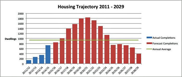
Table of Modifications (Part 1) January 2016 Appendix B
Amendments to Policy DS11 (see Mod 10 above)
DS11 Allocated Housing Sites
The following sites, as shown on the Policies Map, will be allocated for housing development and associated infrastructure and uses:
| Ref | Site | Number of Dwellings (estimated) |
Area of Emp. Land |
Infrastructure Requirements and Other Uses |
|---|---|---|---|---|
|
Urban Brownfield Sites |
||||
|
DELETED: Land at Myton School, Myton Road |
DELETED: 125 0 |
0 |
||
|
H02 (part) |
Former Sewage Works, south of Harbury Lane |
215 |
0 |
Country Park |
|
H09 |
Kenilworth School Site |
250 |
0 |
|
|
H10 |
Station Approach, Leamington |
INSERTED: Included in |
0 |
|
|
H11 |
Land at Montague Road |
140 |
0 |
|
|
H12 |
Kenilworth VI Form College |
130 |
0 |
|
|
H13 |
Soans Site, Sydenham Drive |
DELETED: 100 INSERTED: 147 |
0 |
|
|
H14 |
Riverside House |
100 |
0 |
|
|
DELETED: H15 |
DELETED: Leamington Fire Station |
DELETED: 0 |
DELETED: 0 |
|
|
(1) H16 |
Court Street |
DELETED: 70 INSERTED: 121 |
0 |
|
|
H17 |
Garage Site, Theatre Street |
INSERTED: Included in |
0 |
|
|
H39 |
Opus 40, Birmingham Road, Warwick |
DELETED: 100 INSERTED: 85 |
0 |
|
|
Greenfield Sites - Edge of Warwick, Whitnash and Leamington |
||||
|
H01 (part) |
Land West of Europa Way |
INSERTED: 50 (plus 1160 |
0 |
ExtendedINSERTED: /new Secondary School, Primary School, Health Facilities, Local Centre, Sports Stadium and associated facilities. |
|
H02 (part) |
Land south of Harbury Lane (excluding former sewage works) |
INSERTED: 620 (plus 985 |
0 |
Primary Schools (x2), Local Centre, other Community Facilities, Country Park |
|
(5) H03 |
East of Whitnash/South of Sydenham |
DELETED: 300 INSERTED: 500 |
INSERTED: Land should be reserved as a contingency for the location of a Primary School |
|
|
H04 |
Red House Farm |
250 |
||
|
INSERTED: (137) H44 |
INSERTED: North of Milverton |
INSERTED: 250 |
INSERTED: 0 |
INSERTED: (Total capacity up to 1315 with the balance to come forward beyond the end of the plan period). Potential for some employment land; potential park and ride; Primary School; land/contribution for medical centre; community facilities; potential for new Rail Station (subject to viability) |
|
INSERTED: (5) H45 |
INSERTED: Hazelmere and Little Acre, Whitnash |
INSERTED: 75 |
0 |
|
|
INSERTED: (25) H46A |
INSERTED: Gallows Hill |
INSERTED: 630 |
INSERTED: 0 |
INSERTED: See site H46B below |
|
INSERTED: The Asps |
INSERTED: 900 |
INSERTED: 0 |
INSERTED: Park and ride; primary school; neighbourhood police office; local centre (including a convenience store of no more than 500sq.m gross floorspace), community facilities. |
|
|
Greenfield Sites - Edge of Kenilworth |
||||
|
H06 |
East of Kenilworth (Thickthorn) |
760 |
8ha |
Primary School and Local Centre |
|
H07 |
Crackley Triangle |
INSERTED: Included in |
0 |
|
|
INSERTED: (11) H40 |
INSERTED: East of Kenilworth (Crewe Lane, Southcrest Farm and Woodside Training Centre)* |
INSERTED: 640 |
INSERTED: 0 |
INSERTED: New Secondary School; community facilities |
|
INSERTED: (7) H41 |
INSERTED: East of Warwick Rd, Kenilworth |
INSERTED: 100 |
INSERTED: 0 |
INSERTED: Provide access to sports facilities allocation (see Policy DS NEW4) |
|
Greenfield Site - Edge of Coventry |
||||
|
H08 |
Oaklea Farm, Finham |
20 |
0 |
|
|
INSERTED: (20) H42 |
INSERTED: Westwood Heath** |
INSERTED: 425 |
INSERTED: 0 |
INSERTED: Health Centre; community facilities (quantified in the context of the development of this allocation and the potential wider area over the long term). |
|
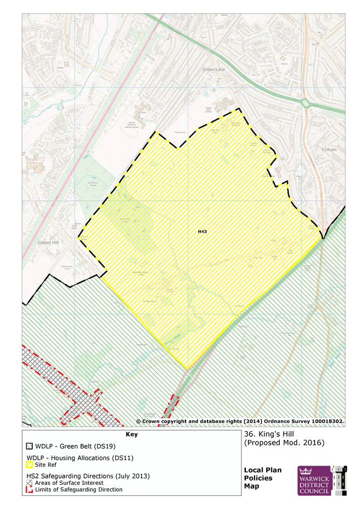
INSERTED: (42) H43 |
INSERTED: Kings Hill Lane** |
INSERTED: 1800 |
INSERTED: 0 |
INSERTED: (Total capacity up to 4000 with the balance to come forward beyond the end of the plan period). Potential for some employment land; potentially land for secondary school provision; new primary schools; local centre and community facilities; health centre; new rail station |
|
Growth Villages |
||||
|
(5)
H19 |
Baginton - Land north of Rosswood Farm |
DELETED: 35 INSERTED: 80 |
0 |
|
|
H20 |
Barford - Land south of Barford House |
8 |
0 |
|
|
H21 |
Barford - Former Sherbourne Nursery |
INSERTED: Included in |
0 |
|
|
H22 |
Barford - Land off Bemridge Close |
12 |
0 |
|
|
INSERTED: (17) H47 |
INSERTED: Barford - Land south of Wasperton Lane |
INSERTED: 30 |
INSERTED: 0 |
|
|
INSERTED: H48 |
INSERTED: Barford - Land South of Westham Lane |
INSERTED: 45 |
INSERTED: 0 |
|
|
H23 |
Bishops Tachbrook - Land south of the school |
INSERTED: Included in |
0 |
|
|
INSERTED: (3) H49 |
INSERTED: Bishops Tachbrook - Seven Acre Close |
INSERTED: 30 |
0 |
|
|
(7) H24 |
Burton Green - Burrow Hill Nursery |
DELETED: 60 INSERTED: 90 |
0 |
DELETED: Community Hall, Village Green and Parking |
|
H25 |
Cubbington - Allotment Land, Rugby Road |
35 |
0 |
|
|
H26 |
Cubbington - Opposite Willow Sheet Meadow |
65 |
0 |
|
|
INSERTED: (42) H50 |
INSERTED: Cubbington - Land east of Cubbington |
INSERTED: 95 |
||
|
H27 |
Hampton Magna - South of Arras Boulevard |
DELETED: 100 INSERTED: 130 |
0 |
|
|
INSERTED: (111) H51 |
INSERTED: Hampton Magna - Land south of Lloyd Close |
INSERTED: 115 |
||
|
(32)
H28 |
Hatton Park - North of Birmingham Road |
DELETED: 80 INSERTED: 120 |
0 |
|
|
INSERTED: (160) H53 |
INSERTED: Hatton Park - Brownley Green Lane |
INSERTED: 55 |
0 |
|
|
(2) H29 INSERTED: and H30 |
Kingswood - Meadow House and Kingswood farm |
DELETED: 10 INSERTED: 30 |
0 |
|
|
DELETED: H30 |
DELETED: Kingswood - Kingswood Farm |
DELETED: 10 |
DELETED: 0 |
|
|
H31 |
Kingswood - South of The Stables |
6 |
0 |
|
|
H32 |
Kingswood - R/O Brome Hall Lane |
12 |
0 |
|
|
H33 |
Kingswood - West of Mill Lane |
DELETED: 5 INSERTED: 8 |
0 |
|
|
DELETED: H34 |
DELETED: Leek Wootton - The Paddock |
INSERTED: No longer available as stand-alone site (part of Police HQ Masterplan) |
0 |
DELETED: To be developed jointly with H35 |
|
DELETED: H35 |
DELETED: Leek Wootton - East of Broome Close |
INSERTED: No longer available as stand-alone site (part of Police HQ Masterplan |
0 |
DELETED: To be developed jointly with H34 |
|
DELETED: H36 |
DELETED: Leek Wootton - Former Tennis Courts |
INSERTED: No longer available as stand-alone site (part of Police HQ Masterplan |
0 |
|
|
H37 |
Leek Wootton - Car park East of The Hayes |
5 |
0 |
|
|
INSERTED: (4) DSNEW3 |
INSERTED: Leek Wootton - Former Policy HQ*** |
INSERTED: 115 |
INSERTED: 0 |
|
|
H38 |
Radford Semele - North of Southam Road |
INSERTED: Included in |
0 |
|
|
INSERTED: (4) H52 |
INSERTED: Radford Semele - Land at Spring Lane |
INSERTED: 60 |
INSERTED: 0 |
|
|
Other rural sites |
||||
|
H18 |
Former Aylesbury House, Hockley Heath |
20 |
0 |
|
* to be brought forward in accordance with Policy DS12
** to be brought forward in accordance with Policy DS New1
*** to be brought forward in accordance with Policy DS New3
Amendments to Explanation for Policy DS11 - Para 2.41 to 2.53 (see Mod 11 above)
(3) Explanation
2.41 All sites were initially assessed for their suitability for housing in the Strategic Housing Land Availability Assessment. Sites were then appraised using the Council's Site Selection Methodology INSERTED: /Matrix which considered the suitability of each site against the following information:
- The Sustainability Appraisal
- Green Belt Assessment
- Landscape Character Assessment
- Historic Setting Assessment
- Strategic Flood Risk Assessment (SFRA Level 1)
- Habitat Assessment, and
- Strategic Transport Assessment
- The Sustainability Appraisal
- Green Belt Assessment
- Landscape Character Assessment
- Historic Setting Assessment
- Strategic Flood Risk Assessment (SFRA Level 1)
- Habitat Assessment, and
- Strategic Transport Assessment
2.42 Sites were also assessed against the INSERTED: spatial strategy including the potential to lead to a coalescence of settlements and the loss of employment land. A figure for the number of dwellings for each site is shown, however it is recognised that this may vary dependant on detailed planning at the application stage. In most cases this figure will represent the minimum site capacity
Urban Brownfield Sites
2.43 A number of brownfield sites will become available as a result of the rationalisation or replacement of public sector land and services. The two Kenilworth School sites INSERTED: and Riverside House DELETED: and Leamington Fire Station will become available when alternative premises have been provided for the existing users. DELETED: The land at Montague Road is available in part and capable of being developed in phases.
2.44 DELETED: Land at Station Approach is partly vacant and the site is being brought forward by a Joint Venture between the Council and a Housing Provider with grant funding from the Homes and Communities Agency. The Council is DELETED: also proactively bringing forward INSERTED: part of the site at Court Street INSERTED: that does not yet have planning permission. Land at Myton School is being made available as part of the proposals to reconfigure and expand this school. The land has potential to help fund the school expansion
INSERTED: 2.45 The Soans site INSERTED: and the site at Station Approach have been assembled DELETED: is currently being assembled for housing development utilising an area where vacancy rates in existing industrial premises are high. INSERTED: These sites gained planning permission for 147 dwellings and 212 dwellings respectively in 2015 DELETED:. The site forms part of a wider area that has potential to deliver canalside regeneration through the support of policy DS14. Opus 40 has also received planning permission during 2015 for 85 dwellings.
INSERTED: 2.46 The site of the former sewage works is set back from Harbury Lane and is sandwiched between the sites at Grove Farm and Heathcote Farm. Thus the site, which requires extensive remediation, cannot come forward until a suitable access from an adjoining site is made available.
INSERTED: 2.47 The site at Aylesbury House is a small brownfield site in the Green Belt, south east of Hockley Heath, with potential for some redevelopment and infilling around the original Aylesbury House INSERTED: with needing to be removed from the Green Belt
INSERTED: 2.48 The small site at Theatre Street INSERTED: has been granted planning permission and adds a further 20 dwellings to a previous permission and is included within the commitments. DELETED: is likely to become vacant within the plan period and provide an opportunity to supplement an existing planning permission and to redevelop and improve this prominent site on the edge of Warwick Town Centre.
Greenfield Sites
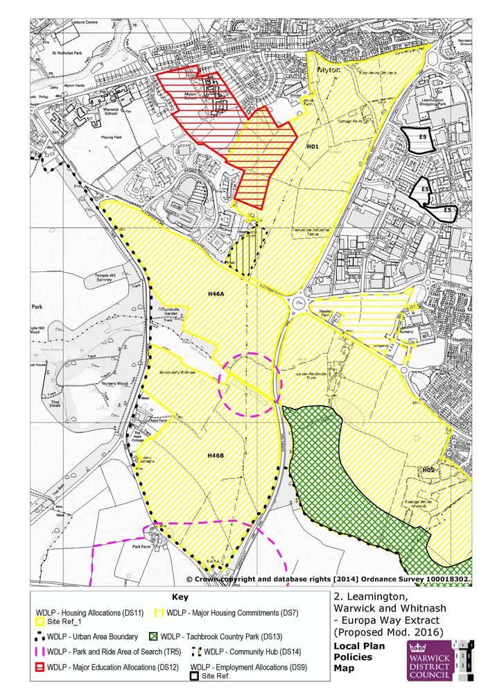
INSERTED: 2.49 The strategic urban extension to the south of Warwick and Leamington comprises of land to the west of Europa Way and land to the south of Harbury Lane. INSERTED: In addition to the sections that are brownfield sites, this area will deliver 2920 dwellings. With the exception of a small section to the south of Harbury Lane (capacity for 105) and a small area west of Europa Way (capacity 50 dwellings), this whole area has been granted planning permission during 2014 and 2015. In addition to the housing, DELETED: T INSERTED: the area will deliver DELETED: up to 2,957 homes along with extended secondary school facilities, three primary schools, DELETED: employment land, local GP services, shops, community facilities and an important buffer of open space to the south to be delivered as a Country Park.
INSERTED: 2.50 The site at Whitnash East provides an extension to the committed site located off St. Fremunds Way, to the south of Sydenham. The site will deliver up to DELETED: 300 INSERTED: 500 homes along with an ecology and landscape corridor adjacent to Whitnash Brook and a partial rebuild and extension of Campion School which will enable access to be provided.
INSERTED: 2.51 Land at Red House Farm forms an extension to Lillington, one of the most deprived neighbourhoods in Warwickshire. The urban extension will provide for up to 250 new homes, of different types and tenures, and support regeneration in Lillington itself.
INSERTED: 2.52 The strategic urban extensions to the east of Kenilworth, at Thickthor INSERTED :n, Woodside Training Centre and Crewe Gardens DELETED: n, will provide for up to DELETED: 760 INSERTED: 1400 new homes and 8 hectares of employment land. Kenilworth has seen relatively little new development in the last 20 years and the new housing which has been provided has been largely at the expense of employment land. This development, therefore, provides the opportunity to deliver new housing and employment in a sustainable location along with the necessary supporting facilities of a primary school, local centre and open space. In order to ensure the delivery of housing and associated uses in Kenilworth, the Council will consider the use of its Compulsory Purchase Powers. DELETED: Later in the plan period a A new secondary school will be provided on land to the north at Southcrest Farm. A further 9 DELETED: 0 INSERTED: 3 homes INSERTED: now have planning permission DELETED: will be provided on a site to the north of the town at Crackley.
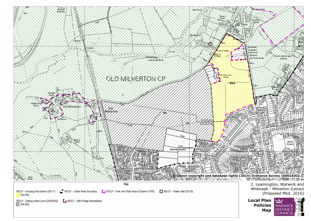
2.53 To the north of Milverton, land for 250 dwellings has been identified with the potential to also include a park and ride and a small amount of employment land. In addition to this allocation, a further area of land has been removed from the Green Belt and safeguarded for the remainder of the plan period
2.54 At Westwood Heath, land has been identified for a residential-led, mixed-use development. Given infrastructure constraints, especially along the strategic and local highways network, the housing to be provided on site is capped at 425 dwellings during the current plan period. However, the creation of improved road infrastructure / additional network capacity could allow for further residential development to be accommodated without undue adverse impacts on local amenity on land that has been safeguarded adjacent to the allocated site.
2.55 At Kings Hill an area of 269ha has been identified for a residential-led, mixed-use development. The site has an overall capacity of c. 4,000 dwellings, with c. 1,800 dwellings being deliverable by the end of the current plan period. The mixed use development will also deliver opportunities for employment provision. Land will be made available for open space, leisure and amenity uses and a green infrastructure network will link to the wider countryside and north to the conurbation. A local centre will be provided at an appropriate scale, incorporating a range of local community facilities and services including meeting space / community buildings, emergency services infrastructure, youth facilities / play areas and local retail provision for convenience shopping. A new primary school will be required to serve the development, which may need to be expanded as the site develops over time.
Village Allocations
INSERTED: 2.56 The majority of the village housing allocations are located on the edge of the existing limits to the built up areas of the village in locations which will provide natural extensions, DELETED: Large sites of over 50 dwellings will be brought forward in phases (see Policy H10) so that the growth of the village can take place more slowly and in proportion to the size of the settlement. This will provide a greater opportunity for the new communities to integrate into the life of the village and for housing to meet local needs which will change over the lifetime of the Plan.
Appendix C - Changes to Policy Map
Revised maps follow table
| Ref | Publication Draft Map | Proposed Modification | Reason |
|---|---|---|---|
|
(2) Mod PM 2a |
Policies Map - 2 Leamington Warwick & Whitnash |
Amendment to Policy Map |
To show:
|
|
(2) Mod PM 2b |
Policies Map 2 -Leamington Warwick & Whitnash |
Amendment to Policy Map |
To show:
|
|
(2) Mod PM 2c |
Policies Map 2 - Leamington Warwick & Whitnash |
Amendment to Policy Map |
To show:
|
|
(10) Mod PM 5 |
Policies Map 5 - Kenilworth |
Amendments to Policy Map |
To show:
|
|
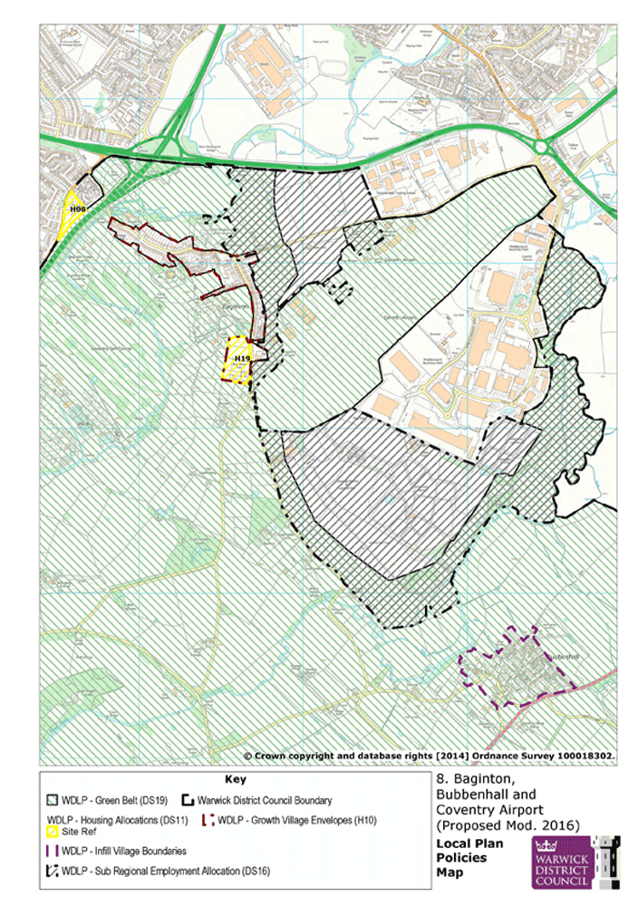
(5) Mod PM 8 |
Policies Map 8 - Baginton, Bubbenhall and Coventry Airport |
Amendment to Policy Map |
To show:
|
|
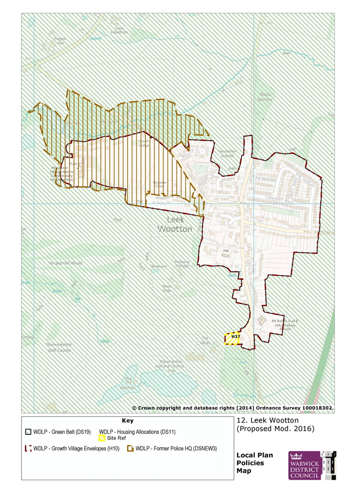
(4) Mod PM 12 |
Policies Map 12 -Leek Wootton, Hill Wootton, Old Milverton and Blackdown |
Amendments to Policy Map |
To show:
|
|
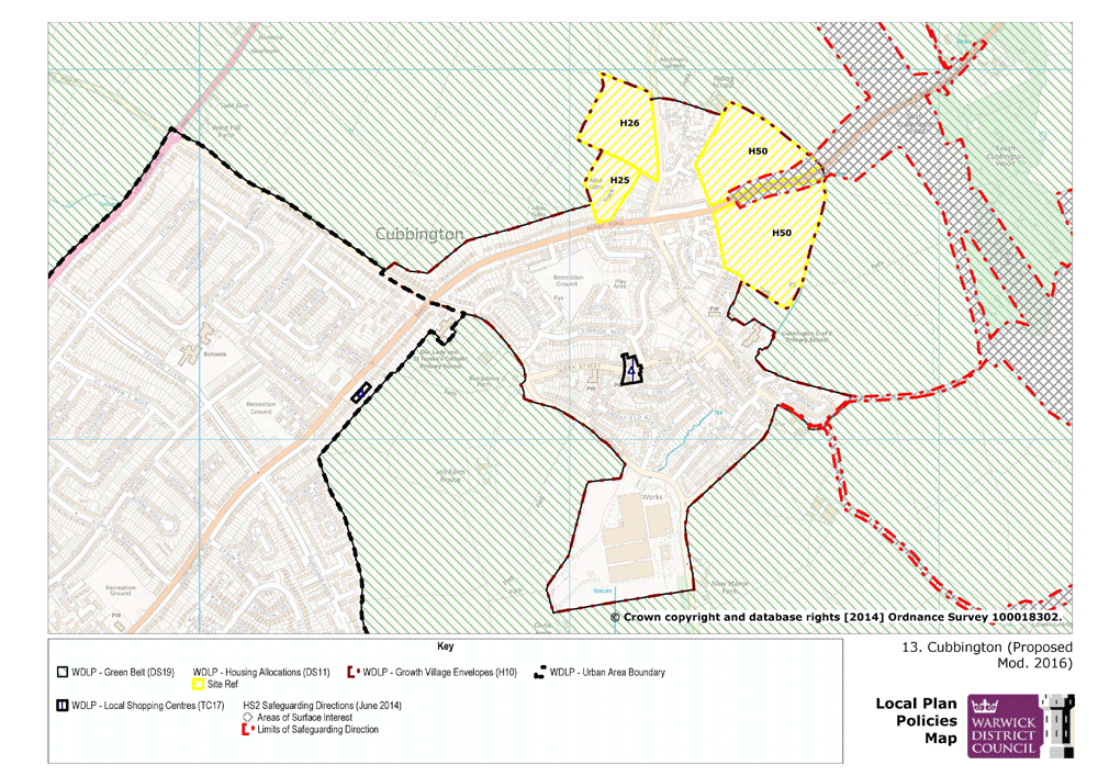
(7) Mod PM 13 |
Policies Map 13 - Cubbington |
Amendment to Policy Map |
To show:
|
|
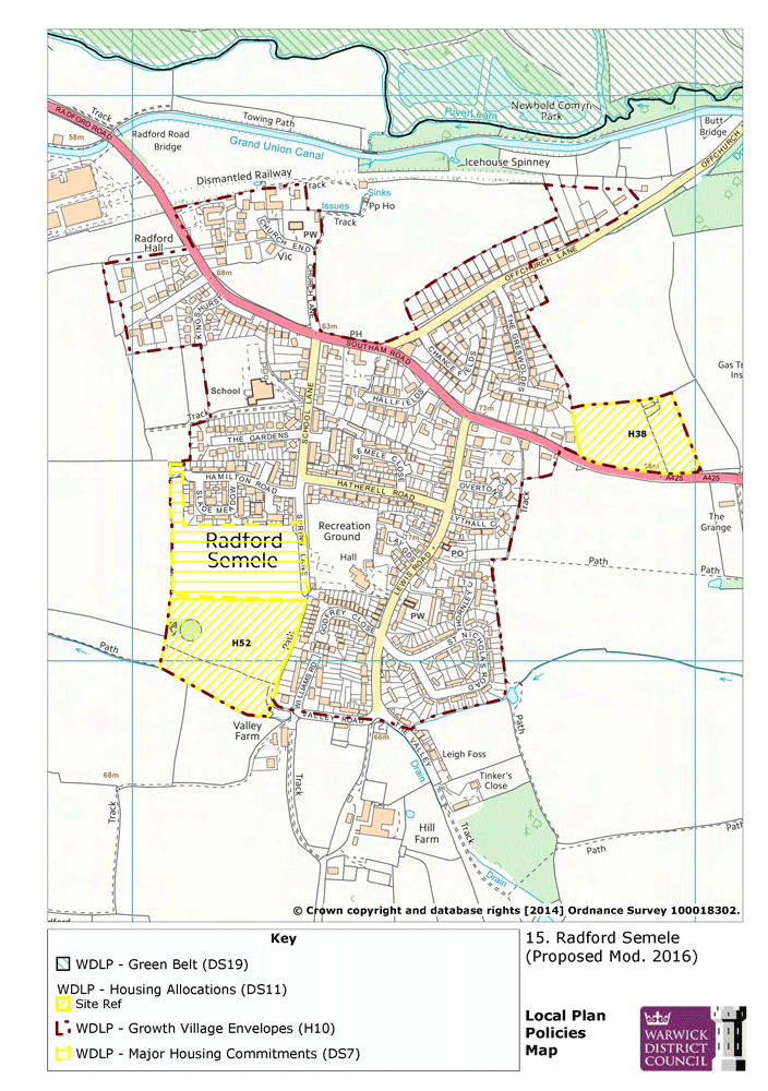
(7) Mod PM 15 |
Policies Map 15 - Radford Semele |
Amendment to Policy Map |
To show:
|
|
(1) Mod PM 16 |
Policies Map 16 - Bishops Tachbrook |
Amendment to Policy Map |
To show:
|
|
(3) Mod PM 18 |
Policies Map 18 - Barford |
Amendments to Policy Map |
To show proposed new housing allocations at:
|
|
(17) Mod PM 20 |
Policies Map 20 - Hampton Magna & Hampton on the Hill |
Amendment to Policy Map |
To show:
|
|
(23) Mod PM 21 |
Policies Map 21 - Hatton Park |
Amendments to Policy Map |
To show:
|
|
(2) Mod PM 29 |
Policies Map 29 - Kingswood |
Amendments to Policy Map |
To show:
|
|
(10) Mod PM 35 |
Policies Maps |
New Policies Map 35 |
To show:
|
|
(9) Mod PM 36 |
Policies Maps |
New Policies Map 36 |
To show:
|
Revised maps
Mod PM2a - Gallows Hill, The Asps and Myton School
ModPM2b - Golf Lane

ModPM2c - Milverton
ModPM5 - Kenilworth

ModPM8 - Baginton, Bubbenhall and Coventry Airport
ModPM12 - Leek Wootton
ModPM13 - Cubbington
ModPM15 - Radford Semele
ModPM16 - Bishops Tachbrook
ModPM18 - Barford

ModPM20 - Hampton Magna and Hampton on the Hill
ModPM21 - Hatton Park
ModPM29 - Kingswood

ModPM35 - Westwood Heath
ModPM36 - Kings Hill
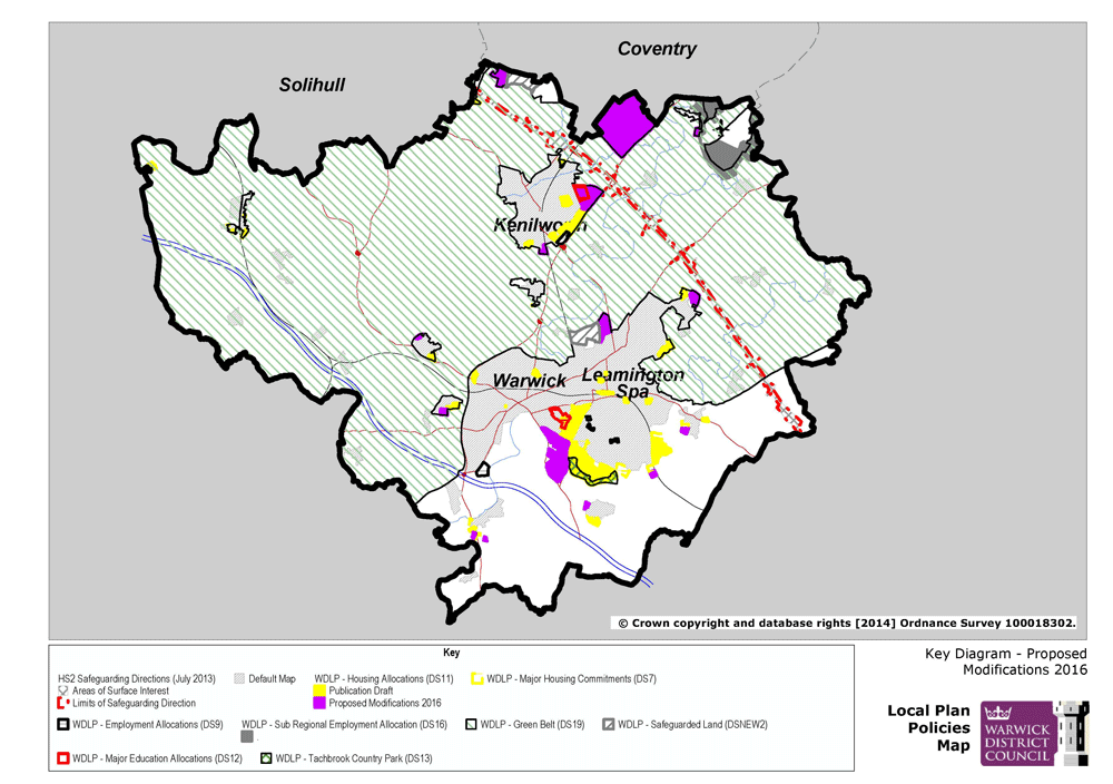
Key Diagram