| Site |
Green Belt? |
PD Land? |
 Red Red
 Amber Amber
 Green Green |
Commentary |
GT01
Land adj. Cobalt Centre, Siskin Drive |
Yes |
No |
Red |
- Green belt site
- Within the planning application boundary of the Gateway employment site and
is annotated as landscaping. It would create a valuable buffer between built development
and the Siskin Bird Sanctuary on the eastern boundary
- Council is committed to the Gateway scheme
- Site would not be deliverable if Gateway proceeds
- Uncertainty over availability
- Partially in Flood Zones 2 and 3
- Smells emanating from sludge lagoons to the south
- Noise from nearby A46 and major highway interchange
- Access issues requiring third party agreement
|
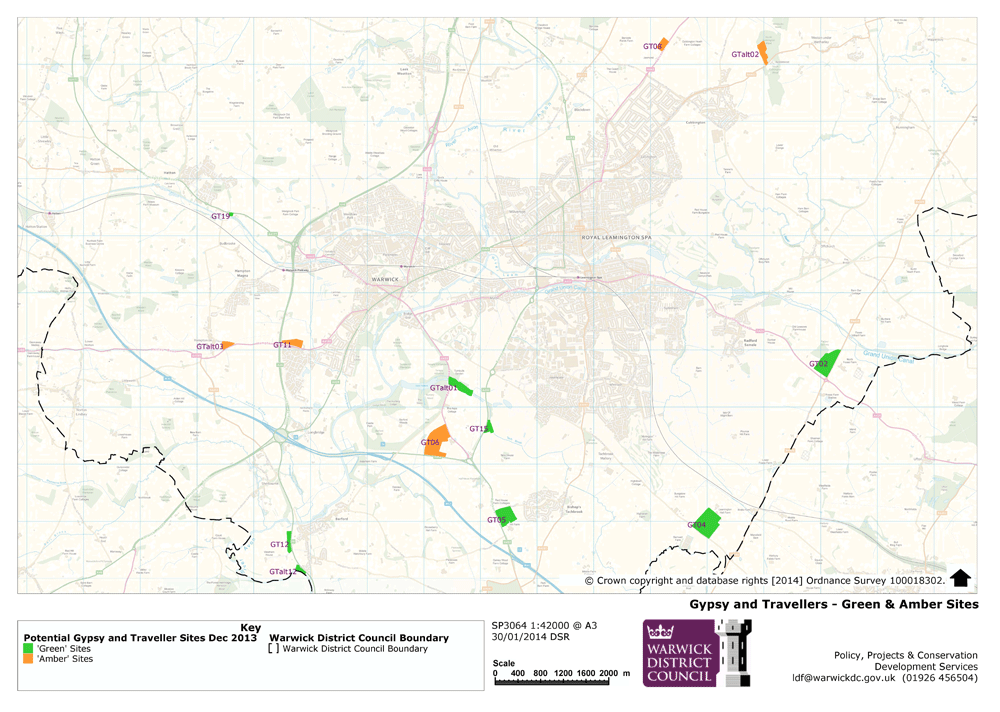
GT02
Land abut- ting Fosse Way at junction with A425 (part) |
No |
No |
Green |
- Not in Green Belt
- Area reduced to two fields on west of Fosse Way
- Access from Fosse Way possible if visibility splays achieved
- Immediate access to popular route for Gypsies and Travellers
- Wholly within low risk flood zone 1 and is sequentially preferable
- Grade 3 and 3a agricultural land
|
GT03
Land at Barnwell Farm |
No |
No |
Red |
- High pressure gas mains affect all but centre of site which is poultry farm
and precludes development
- Mostly within Flood Zone 3
|
GT04
Land at Harbury Lane/Fosse Way (part) |
No |
No |
Green |
- Not in Green Belt
- Site reduced to part currently used by Leamington Football Club
- High pressure gas mains affect large parts of the site on the east and west
- Excluded areas affected by Local Wildlife Sites: Whitnash Brook Local Wildlife
Site (LWS), potential LWS at Fosse Farm, potential LWS adj. to railway cutting
- Excluded area in Flood Zone 3 near Bridle Farm
- Avoiding historic landfill site at Hobson’s Choice
|
GT05
Land at Tachbrook Hill Farm (part) |
No |
No |
Green |
- Not in Green Belt
- Lies within Flood Zone 1 and therefore sequentially preferable
- Site area reduced to avoid noise from major roads, high pressure gas main
on southern part of site and farm complex
- Close to primary road network
|
GT06
Land at Park Farm/Spinney Farm (part) |
No |
No |
Amber |
- Not in Green Belt
- May cause problems for viable agricultural unit
- Proximity to Grade 1 Listed Park and Garden at Castle Park
- Contamination issue related to former landfill site on western third of site
reduces developable area
- May be noise issue connected with proximity to Warwick By-Pass in part
- Lies within Flood Zone 1 and therefore sequentially preferable
- Access should be achievable north of Park Farm
|
GT07
Land at Stoneleigh Road, Baginton |
Yes |
Partially |
Red |
- Green Belt
- Only two fields were found to be worth consideration through ’villages’ consultation
and these are too close to Coventry airport where noise vulnerable caravans should
not be located
- Insurmountable access issues
|
GT08
Depot to west side of Cubbington Heath Farm |
Yes |
Yes |
Amber |
- Green Belt land, but previously developed
- Possible historic filling of old quarry and potential contamination from storage
of road salt
- Potential impact on local wildlife
- Wholly within Flood Zone 1 and therefore sequentially preferable
- Within 1000m of HS2
- Located on sandstone so would need additional assessment to ensure no risk
to groundwater
- Access should be achievable
- Grade 2 agricultural land
- More remote than some sites
|
GT09
Land to north east of M40 |
No |
No |
Red |
- Includes River Avon LWS and Greys Mallory potential LWS
- Grade 2 Listed Building – Greys Mallory
- Ordinary watercourse runs through centre of site which has not been modelled
for potential flood risk
- Historic landfill in west of site with potential mobilisation of contaminants
within groundwater
- Road noise from M40
- Serious access issues
- High pressure gas main cuts through south east corner of site
- Part grade 2 agricultural land
|
GT10
Land at Tollgate House and Guide Dogs National Breeding Centre |
No |
Yes |
Red |
- Serious access issues
- landfill site on eastern corner
- Noise issues close to M40
- Sensitivity of existing use
- Wiggerland Wood potential LWS
- Tach Brook failing in its objectives under Water Framework Directives due
to high levels of phosphates
|
GT11
Land at Budbrooke Lodge, Racecourse and Hampton Road (part) |
No |
No |
Amber |
- Not in the Green Belt
- Reduced site area due to areas in Flood Zone 3 and potential road noise issues
from A46
- Gog Brook modelled so confident of extent of floodplain
- Uncertainty over impact on racecourse and Budbrooke Lodge
- Includes Gog Brook LWS
- Immediately adjacent to local services and facilities at Chase Meadow
- Edge of urban area
- Close to primary road network
- Good pedestrian access
- Vehicular access may be achievable but Budbrooke Lodge access preferred
- May be able to connect to main sewers serving Chase Meadow
|
GT12
Land north and west of Westham Lane (area of search) (part) |
No |
No |
Green |
- Not in Green Belt
- Reduced area to allow viable agricultural use of remainder and avoiding areas
in Flood Zone 3
- Site immediately adjacent to services and facilities in Barford
- Close to primary road network
|
GT13
Kites Nest Lane, Beausale |
Yes |
No |
Red |
- Green Belt
- Unauthorised Gypsy and Traveller site has been subject of retrospective planning
applications and two subsequent appeals, both dismissed
- Remote from services and facilities
- Remote from primary road network
- High quality landscape
- Access issues
|
GT14
Warwick Road, Norton Lindsey |
Yes |
Yes |
Red |
- Green Belt
- Potential contamination from former use as poultry farm
- •Remote from primary road network
- Some access issues
- Very awkward shaped site to develop for one or two pitches
|
GT15
Land east of Europa Way (part) |
No |
No |
Green |
- Not in Green Belt
- Site area reduced to take account of flooding
- Well screened
- Close to primary road network
- Close to edge of urban area, facilities and services
- WCC owned land which can be made available
- Deliverable
- Access achievable
|
GT16
Land west of A429 Barford (small site) |
No |
No |
Red |
- Flood Zone 3
- Drainage area for Barford By-Pass
|
GT17
Service area west of A46 Old Budbrooke Way |
Yes |
Yes |
Red |
- Green Belt
- Highways Agency will not allow new access or the existing access to be utilised
for an additional use
- Acute noise and air quality issues from A46
- Remote from services and facilities
|
GT18
Service area east of A46 Old Budbrooke Way |
No |
Yes |
Red |
- Highways Agency will not allow new access or the existing access to be utilised
for an additional use
- Acute noise and air quality issues from A46
|
GT19
Land off Birmingham Road, Budbrooke (part) |
Yes |
Yes |
Green |
- Green Belt but previously developed land
- Site area reduced to avoid other existing uses and retain viability of remaining
unit
- Possible use of existing access points
- Close to primary road network
- Services available on site as currently used by Caravan and Camping Club
|
GT20
Land at J15 of M40 |
Yes |
Partially |
Red |
- Green Belt
- Part of River Avon LWS and potential LWS
- Impact concerns on wildlife
- Not desirable in terms of potential impact on water environment
- Warwickshire Habitat Alert Site and pond
- Large proportion of site in Flood Zone 3
- Noise and air quality issues from surrounding road network including M40 and
A46 and new road system with roundabout at Sherbourne
- Hedgerow Retention Notice 69m from eastern boundary
- Highly visible being set lower than surrounding roads
- Access unlikely to be achievable
- Remote from services and facilities and no pedestrian access
|
| Site |
Green Belt? |
PD Land? |
Red
Amber
Green |
Commentary |
GTalt01
Brookside Willows, Banbury Road |
No |
Yes |
Green |
- Not in Green Belt
- Has planning permission for holiday caravan site
- Close to edge of urban area
- Well screened
- New access created with turning lane from Banbury Road to highway standards
for caravan park
- Flooded watercourses drain to road rather than onsite
- Planning conditions on existing permission deal with issues of contamination
from landfill
- Landfill details/potential risks known from previous work carried out for
planning application
- Existing pedestrian access
- Close to primary road network
|
GTalt02
Land off Rugby Road, Cubbington |
Yes |
Partially |
Amber |
- Green Belt but previously developed
- North Cubbington Wood is replanted ancient woodland
- Some surface water flooding on small area in south east corner
- Remote from services and facilities
- Existing access likely to be suitable to serve site, but visibility splays
may not be achievable and intensified use of site may be detrimental to public
highway safety. Speed survey would be required if progressing this site
- Landowner considers unlikely to be viable as would include purchase of North
Cubbington Wood as well as timber yard business
|
GTalt03
Henley Road/ Hampton Road |
Yes |
No |
Amber |
- Green Belt
- Access achievable along Hampton Road
- On public transport route
- Pedestrian access
- Landowner very keen to promote site for this use
- Available and deliverable
|
GTalt04
Station Road, Hatton |
Yes |
No |
Red |
- Green Belt
- High landscape area
- Station House Grade II Listed Building
- Noise from railway
- Surface water flooding along eastern edge
- Remote from all services and facilities
- Station Road unsuitable to serve caravans
- Access could not be achieved
- Already assessed for residential use and found unsuitable
|
GTalt05
West of Europa Way |
No |
No |
Red |
- No existing access and difficult to achieve
- Narrow site which, once access road taken out of site area, would leave no
space for pitches. Site has insufficient depth
- Site is not suitable for caravans in access terms
|
GTalt06
Land at Warwick Gates/Trident park (junction of Heathcote Lane with Macbeth Approach) |
No |
No |
Red |
- Site currently allocated as employment land
- Site is likely to be allocated for residential development in Draft Local
Plan
- Access only off Macbeth Approach would be restricted to conventional housing
|
GTalt07
Field west of Leicester Lane, Cubbington |
Yes |
No |
Red |
- Green Belt
- High landscape value
- Open to views from west
- Difficult to achieve access
- Restrictive covenant on land to resist development
|
GTalt08
Employment Land, Lower Cape, Warwick |
No |
Yes |
Red |
- Allocated employment land and part of district’s employment land portfolio
- Industrial estates are not suitable for any type of residential use
- Planning permission has been recently granted to develop this
- part of the site for employment use
|
GTalt09
Former Ridgeway School, Montague Road |
No |
Yes |
Red |
- Potential noise and air pollution from adjacent employment area which would
impact on caravans
- Potential LWS on southern boundary
- Likely to be allocated for residential use in Draft Local Plan
|
GTalt10
Land off Welsh Road, Cubbington |
Yes |
No |
Red |
- Green Belt
- Flood Zones 2 and 3 through centre of site
- No public transport access and no footpaths
- Owners wish to retain site for expansion of existing business once flood attenuation
measures are carried out
|
GTalt11
Stoneleigh Showground |
Yes |
Yes |
Red |
- Green Belt
- Part Registered Park and Gardens
- Site is protected for specialist rural-based employment uses
- LWS around buildings
- Flood zones 2,3,3a and 3b
- Remote from facilities
- Access issues unless it can be proven that there would be no intensification
in traffic using existing access to site
- Not deliverable
|
GTalt12
Land west of Barford By-Pass |
No |
No |
Green |
- Not in Green Belt
- Flood zones 2,3,3a only along edge of river bank
- Close to services and facilities at Barford
- Close to primary road network
- Access can be achieved
- Partly owned by WCC
|
GTalt13
Land off Old Warwick Road, between Rowington and Shrewley |
Yes |
No |
Red |
- Green Belt
- Surface water flooding on southern boundary
- Access not achievable and road not suitable to serve caravans
- due to lack of visibility
|
GTalt14
Land north of Fortress House, Stratford Road |
No |
No |
Red |
- Within Cordon Sanitaire of sewage works with accompanying smells
- Flood Zones 3, 3a and 3b on northern third of site. Flood Zone 2 across eastern
quarter of site
- Unsuitable for any residential use
|
GTalt15
r.o. department store, Leamington Retail Park |
No |
No |
Red |
- Surface water flooding across southern half of site and smaller area on eastern
half
- Part of retail/employment sites
- Access would have to be from Olympus Way
- Very urban setting not suitable for this use
|
GTalt16
Gateway proposed employment site |
Yes |
Yes |
Red |
- Green Belt
- LWS/ancient woodland on part of site
- Parts of site are in Flood Zones 2 and 3
- Possible contamination from former uses
- Uncertainty over future of site but Council committed to Gateway employment
site proposal
|
GTalt 17
Sydenham Industrial Estate (vacant units) |
No |
Yes |
Red |
- Areas of surface water flooding throughout the site
- Industrial site unsuitable for residential use, particularly caravans which
are vulnerable to noise
|
GTalt18
Land off Stoneleigh Road, Baginton |
Yes |
Yes |
Red |
- Green Belt
- Two small areas subject to surface water flooding
- Remote from services and facilities
- No public transport provision
- Access not currently achievable due to carriageway alignment
|
GTalt19
Castle Park, Warwick |
No |
Yes |
Red |
- Grade I Registered Park and Garden
- River Avon LWS
- Stands of trees subject of TPO’s
- Designed landscape in Conservation Area
- Would require new access to be taken off Banbury Road
- Unsuitable for development
|
GTalt20
Land off Ranelagh Street |
No |
Yes |
Red |
- Major part of site susceptible to surface water flooding
- Contamination due to industrial processes on site
- Canal is LWS
- Unlikely to be unsuitable on highway grounds
- Current owners have not indicated any intention to relocate
|
GTalt21
South east of Leamington Golf and Country Club |
No |
No |
Red |
- High pressure gas main runs through centre of site. Including
- buffer zone, there is no developable land remaining
- Surface water flooding potential on northern boundary
- Width and condition of Golf Lane precludes use as access for vehicles likely
to be associated with the site
- Unsuitable for any development
|
GTalt22
Extend caravan site at Warwick racecourse |
No |
Yes |
Red |
- LWS
- Conservation Area
- Likely to flood on south west corner
- Very open and conspicuous
- Access would have to be shared with Camping and Caravan Club access
- As a Caravan and Camping Club site, this use would not be suitable
|
GTalt23
Althorpe Street (vacant units) |
No |
Yes |
Red |
- Canal is LWS
- Large area susceptible to surface water flooding
- Railway runs along north and west boundary with associated noise issues
- Industrial sites are not suitable for any type of residential use
|
GTalt24
Land off M40 junction at Sherbourne |
Yes |
No |
Red |
- Whole site within Flood Zones 3, 3a and 3b
- Whole site susceptible to surface water flooding
- Immediately adjacent to J15 of M40
- Noise from M40 and A46
- Adjoining Sherbourne Conservation Area
- Site suffers from permanent flooding and is unsuitable for any kind of development
|