Kenilworth Neighbourhood Plan - Submission
(14) 5. Vision, Objectives & Land Use Policies
Vision
5.1 The Vision for Kenilworth is:
The growth of Kenilworth provides an opportunity to preserve the character and improve the quality of life for both present and future generations, by protecting our heritage and improving our environment, making it the town and the community where we all wish to live and work, and which people want to visit.
Objectives
5.2 To achieve this vision a number of key objectives have been identified as follows:
- Housing - to ensure that the style, design and layout of housing builds on the unique character of Kenilworth and meets the needs of the Town
- Community - to ensure that new development is absorbed into the community and that appropriate facilities are created and maintained
- Green spaces (including Abbey Fields) - to protect, enhance and utilise the green spaces in and around the Town and to ensure that they are properly maintained
- Town Centre - to encourage and enable a thriving, safe and
accessible town centre for retail, dining, employment and
leisure uses as well as residential
- Transport links - to better connect all parts of the town both internally and externally by all means of transport
- Heritage - to protect, appreciate and exploit the historic aspects of the town
Land Use Planning Policies
5.3 Land use policies are used to determine planning applications made for development proposals. They can establish the principles for retaining or changing the use of land in settlements and in the countryside. They can also set out the conditions against which development proposals will be judged in terms of their design, access etc.
5.4 The purpose of these policies is to either encourage planning applications to be made for things the local community wants to see happen or to discourage applications for developments that they do not want to happen. Policies must be clearly written so they can be easily applied when considering planning applications.
5.5 The plan deliberately avoids repeating existing national
or local planning policies. The proposed policies therefore
focus on a relatively small number of key development issues in
the area. For all other planning matters, the national and local
policies of other planning documents – the National Planning
Policy Framework and the policies of the various Warwick
development plan documents - will continue to be used. The
Neighbourhood Plan also looks to the reasoning of the policies
and the evidence base of the new Local Plan.
5.6 Set out below are the proposed policies of the Plan. Each policy has a number and title and the policy itself is written in bold italics for ease of reference. There is also a short statement explaining the intention of the policy and any other relevant background information. At the end of this document are the Policies Maps – where a policy refers to a specific site or area then it is shown on the Maps.
SITE-BASED POLICIES
Policy KP1: Town Centre
- The Neighbourhood Plan allocates land at Smalley Place, as shown on the Policies Map 5.3, for the provision of a Town Arts Centre and Hall.
- Proposals for the upgrading of medical facilities at Smalley Place, as shown on the Policies Map 5.3, will be supported.
- Proposals to improve Abbey End to reflect the need for improved pedestrian space in the Town centre will be supported. The Neighbourhood Plan defines an extended primary shopping frontage in the Town Centre to include Abbey End as shown on the Policy Map 5.3.
- Proposals to improve the appearance of the rear of the Abbey End shops will be encouraged and supported.
- All changes to shop fronts in Warwick Road, The Square, Abbey End and Station Road should be in accordance with the Kenilworth Design Advice (see reference in the evidence base)
- Proposals for a two-storey car park at Square West and/or at Abbey End, as shown on the Policies Map 5.3, will be supported, provided the ground floor is semi-sunk so that a second tier is not be at a high level so that the overall height is minimised in the interests of visual amenity and to reduce the impact on neighbouring properties and that EV charging points and secure bicycle parking are included in accordance with current requirements.
- Proposals to introduce a 20mph or similar speed restriction Zone in the Town Centre and adjoining roads will be supported provided it does not involve speed humps.
- Proposals in general which help to improve the air quality in the town centre will be supported.
5.7 This policy complements the existing development plan policies that define the Town Centre and its primary and secondary shopping frontages. It contains a number of site-specific proposals that together are aimed at enabling the town centre to serve a larger local population in the coming years.
5.8 A major objective of that original plan and confirmed in the Action Plan was the creation of a Civic Centre at Smalley Place, which would then include the Town Council Offices, the Library and the District and County One Stop Shop. The acquisition of Jubilee House means the Town Council Offices, a Police office and the MP's Office are already under one roof. Its refurbishment and the introduction of Warwickshire Direct into the Library have achieved many of those objectives.
5.9 The same plan also proposed that the Centre should also make provision for a theatre, hall or arts centre in this same area and this still remains a major proposal. Much work has been done in relation to this proposal by the District and Town Councils and the draft designs prepared have clearly shown that this Centre could be achieved on the Smalley Place site between the existing Library and Jubilee House. This building could not only provide a new home for a local theatre but also an occasional cinema and meeting hall. Arrangements would have to be agreed to manage the facility and co-ordinate the various potential activities and uses. The development would enable the Town to have a new and modern theatre. Furthermore, the community uses of the Centre would allow the subsidy of this project because of their contribution to the public good. This policy simply allocates land. Progress on the project will depend on future decisions and funding opportunities.
5.10 An original aim when the District Council purchased Jubilee House was to re-house the Primary Care Trust Clinic on the ground floor and thus provide a modern facility for the Clinic patients and staff, in place of the ageing current facility which is in need of replacement. This proposal stalled because of the reorganisation of the Health Service. Whatever the change in the structure of the Health Service we assume and expect that a clinic will still be provided and the redevelopment of the clinic site would be a beneficial move for all concerned.
5.11 The Abbey End shopping centre was renovated and its frontage landscaped in accordance with the 2004 Town Centre Plan, and has settled and developed reasonably well. Unfortunately, the enhancements proposed for the rear of the building facing the car park were not completed. This objective should become part of planning policy and the current Tenants and Owners should be encouraged to put those proposals in hand so as to provide access and shop fronts to that side. This would then present a more pleasing and attractive aspect to the car park and encourage entrance to those businesses direct from the Abbey End car park. This improvement has become even more essential with the development of the Kenilworth Centre, The Senior Citizens Club and the redevelopment of the housing at Wilton Court. These three important new developments provide a new opportunity for Abbey End to have a more pleasing aspect at both front and rear as effectively a new street front would be created on the other side of the car park.
5.12 The area to the front of Abbey End has effectively become the Town Square and market place as a result of the developments already carried out and those now granted planning permission at Talisman Square. This new status will require more detailed planning to encourage and ease pedestrian access to it. This would require the realignment of traffic access through that area so that the area used by the traffic island became part of the structure of the square, with possible relocation of the bus and taxi stands. The Primary Retail Frontage has been extended to over the shops at Abbey End. This relates to the new Local Plan policy TC6.
5.13 Unfortunately the development of the shops in Warwick Road has occurred with little coordination of shop front design and the result does not present a pleasing street scene. Whilst it is appreciated that this situation cannot be altered overnight it is felt essential that there should be a Design Policy for the shop fronts in the Town Centre in general and this policy has been strongly supported. We would propose that the Kenilworth Civic Society's Shop Fronts Guidance be adopted as part of our plan. This would then provide a basis to improve the street scene in the future as shop fronts are renewed, and give some conformity to the main shopping centre. This Kenilworth Design Advice should include advertising and A boards to reduce the current clutter in the street scene.
5.14 The Town car parks are already well used and on many
occasions are perceived as being completely full. With the
addition of 2,000 houses on the new developments, we envisage
that there will be insufficient parking in the Town centre. It
is our intention to take advantage of the new developments to
increase the viability of the Town Centre for the benefit of the
Town as a whole and therefore it is essential that not only is
there easy access to the Town Centre by all means of local
transport, but also that if pressure increases some more parking
provision is made available. There are some strong views against
providing extra parking and thereby encouraging car use but in
contrast many people consider it unrealistic in a town of very
high car ownership to fail to provide more parking and threaten
the viability of Town Centre shops and other businesses. There
is however no suitable land available for further surface car
parking. The locations of the existing car parks do not lend
themselves to conventional multi-storey parking as they are
close to residential development and our Survey showed that this
would not find support, but there is support in the Consultation
for an option similar to the Waitrose car park with the ground
floor being semi-sunk so that a second tier need not be at a
high level. This would also allow for Pay on Foot parking which
we believe would encourage shoppers to stay longer. Such a
scheme could probably be more easily built at Square West but a
similar method of construction could be considered in Abbey End
Car Park where advantage could be taken of the existing slope.
5.15 Warwick Road, the main shopping street in the town centre, carries heavy traffic throughout the day and has poor air quality as does New Street. Both of these sites are being monitored. A Report on air quality is referenced in the evidence base.
Policy KP2: Station Road
Proposals to manage traffic on Station Road between the Town Centre and Priory Road, as shown on the Policies Map 5.3, will be supported. Proposals for the redevelopment or change of use of land on Station Road must not obstruct or hinder pedestrians using the footways and should have regard to the desire to improve pedestrian and cycling links between the Town Centre and the station.
Proposals to redevelop land on Priory Road, Waverley Road or Station Road in the general vicinity of the new railway station, as shown the Policies Map, will be supported if they will enhance the appearance of the route between the station and Town Centre and will encourage a greater movement between the two.
5.16 This policy acknowledges the increasing importance of Station Road in connecting the Town Centre with the new railway station, which is due to open in 2018. The station lies only a short walking and cycling distance from the Town Centre and the road is a residential street for the most part. It was decided when the plans for the Town Centre were adopted several years ago that the eventual aim was to make the Warwick Road end of Station Road from the car park entrance onwards, pedestrian friendly by using block paving and slowing traffic to allow a mix of vehicles and pedestrians in a manner similar to West Street in Warwick. This plan met with mixed reaction in our Survey and the Consultation. If advanced should be subject to further careful consideration as to its feasibility.
5.17 A successful station is likely to create pressures for change and redevelopment in its vicinity on Station Road, Priory Road and Waverley Road. The policy encourages such proposals provided they will enhance the appearance of the route to pedestrians and cyclists by changes such as improving pavements and introducing a contra-flow cycling lane. There will also be a need to review bus routes involving the Station and the Town Centre.
Policy KP3: Warwick Road Special Policy Area
The Neighbourhood Plan designates Warwick Road, from the Town Centre to Leamington Road, as shown on the Policies Map 5.2, as a Special Policy Area. Proposals for A2/A3 commercial uses, B1 business uses and C1 hotel uses will be supported in the Area, provided they have regard to the heritage, design and other relevant policies of the development plan.
Proposals in general which help to improve the air quality in the Warwick Road Special Policy area will be supported.
5.18 This policy identifies the section of Warwick Road between the Town Centre and the A452 as requiring special policy action, given its importance in linking the major housing development areas of the town with the Town Centre. An increase in road traffic and footfall along this route is likely to create pressures for land use change in the area that need to be managed carefully. The road contains a number of residential properties and a variety of commercial and other uses and so the principle of mixed uses is well established. The increase in the prominence of the route would make it attractive to more commercial uses that are not essential to a location in the Town Centre, i.e. financial services and café/restaurants, and to hotel uses. It is not well suited to an increase in public houses or hot food takeaways as this will likely harm the amenities of the existing residential properties.
5.19 Warwick Road, the main road through the town centre, carries heavy traffic throughout the day and has poor air quality.
Policy KP4: Land East of Kenilworth
Development proposals for housing and other uses on land released from the Green Belt east of Kenilworth, as shown on the Policies Map 5.2, will be supported where they represent a comprehensive development scheme for the land in accordance with a Development Brief produced by Warwick District Council and comprise the following principles:
- The provision of land for a secondary school, sixth form college and if deemed the most appropriate location a new primary school within the allocation, and/or financial contributions on the northern parcel of land;
- The provision of land for a new primary school on the southern land parcel if deemed an appropriate location;
- The provision of a local centre comprising a mix of A1-A5 commercial uses and D1 community facilities, including possible medical and youth facilities and places of worship, to meet identified local needs that are also accessible to the existing residential areas of eastern Kenilworth;
- The provision of a distinct area at Thickthorn for B1 and suitable B2 business uses only, with direct vehicular access to A452 Leamington Road or direct to the A46 junction, the layout and design of which must enhance the entrance to the town from the A46 junction and must be compatible in uses with the amenities of adjoining residential areas;
- The provision of 5% of the total number of the open market homes as serviced plots for self-build and custom build;
- The adoption of a highways strategy based on independent access to each of the land parcels that allows for an arrangement of uses and access routes to connect the development with the existing built up area at multiple points by walking, cycling, public transport and car;
- Residential roads within the developments are designed to a 20mph standard and give priority to pedestrians and cyclists;
- The provision of a green corridor through the various land
parcels that:
- is arranged in such a way as to benefit the new development and the existing community;
- functions as a linear route linking the school sites and local centre;
- comprises and connects to pedestrian and cycle routes, public open space, the provision of new allotments and other forms of green infrastructure;
- incorporates Rocky Lane and Glasshouse Wood path and other public rights of way and footpaths on the land as a means of improving access from the town to Stoneleigh and the River Avon;
- retains and integrates as much of the existing wooded areas such as Glasshouse Spinney, Crewe Lane Arboretum, the spinneys at Thickthorn and Jordan Closes and other landscape features as practical;
- The creation of a soft edge along Crewe Lane, retaining the belt of trees and a similar frontage to Glasshouse Lane;
- The protection of the residential amenity of the existing development along Leamington Road, Glasshouse Lane, Birches Lane and the roads off towards the developments including the planted verges in such areas ;
- The layout and appearance of the development shall minimise harm to and where appropriate enhance the historic environment and heritage assets on or near to the site;
- The agreement of an environmental strategy to establish how the development of the land will deliver a net biodiversity gain, will manage the sustainable drainage of the land and will avoid harm to the setting of adjoining heritage assets;
- The agreement of a phasing plan and delivery strategy that will enable self-contained phases of development to come forward and will set out the thresholds by which the provision of site infrastructure and non-housing uses will be required.
5.20 This policy establishes the key development principles for the planning and delivery of new development of 1,400 new homes and 8 Ha of business land to the East of Kenilworth over the plan period. The land comprises agricultural, recreational and other open land at Thickthorn and the sports pitches up to Glasshouse footpath and Southcrest Farm, as shown on the Concept Plan Map below. There are several different land ownerships and arrangements for promoting and delivering development. The adoption of the new Local Plan in 2017 released the land from the Green Belt for development.
5.21 The policy is therefore not allocating the land for development but is seeking to be a positive and helpful bridge between the allocation policy of the Local Plan and the comprehensive site Development Brief that will guide future planning applications. It is derived from a Joint Statement prepared by the Town Council, District Council and land interests in September 2016 that was submitted to the examination of the Local Plan in October 2016. (See Appendix D) Its intent is to detail the key opportunities and strategic constraints of the sites to inform a high level illustrative concept plan. In doing so, it identifies the key strategic infrastructure requirements in order to support Local Plan allocations and the issue of viability. The involvement of all the key parties in the Joint Statement demonstrates the value of collaborative working between the landowners/promoters, the District and Town Councils on the approach and evolution to the preparation of a draft illustrative concept plan for East of Kenilworth. Warwick District Council is now producing a detailed Development Brief for the area which will build on the agreements reached and may indeed reflect the policies detailed above.
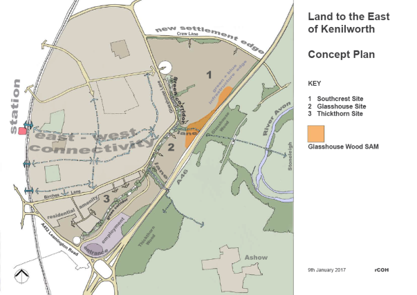
Concept Plan – Land East of Kenilworth
5.22 There are no constraints on the land which prevent development, now it is released from the Green Belt, other than the presence of a Scheduled Monument on its eastern edge. The land interests produced technical evidence demonstrating the deliverability of the sites at the Local Plan Examination in Public. They showed that there are not any technical impediments that would prevent the delivery of the allocations, subject to normal development management considerations and design detail which will be determined through planning applications.
5.23 The total number of homes provided for in the Local Plan is 1,400; all of which can be delivered by the end of the plan period. The Local Plan requires that a wide range of housing types and tenures including 40% affordable housing is delivered; this policy adds that 5% of the total number of the open market homes should be provided as serviced plots for self-build and custom build in line with the Government's encouragement of this form of housing delivery. Although self-build remains novel in this country, there is already some interest in Kenilworth. As of February 2018 there were 30 expressions of interest specifically for Kenilworth and another 70 seeking unspecified plots somewhere within Warwick District. The precise means of delivering this requirement will be addressed in the Development Brief.
5.24 The Local Plan also requires that 8 Ha of business land is delivered in the southern corner of the site closest to the strategic highway network. This area represents a major opportunity to grow the base of higher value added, higher job density businesses in the town. There is a growing demand for such locations, not least to enable new businesses to spin out of the nearby University. Conversely, the allocation is not suitable for the types of business uses that may cause long term conflicts between the amenities of occupiers and nearby residential properties. This need not entirely rule out B2 uses, but they should ideally be ancillary to a B1 use on the site and should not be located prominently in the appearance of the site, nor close to the existing or planned residential areas.
5.25 It also requires the provision of land to enable the relocation and consolidation on one site of Kenilworth School and land on the northern edge has been earmarked for that purpose. Consultations with the County Council have shown that the land must also provide for new primary school facilities. This provision should be positioned and developed to enhance the existing primary school facilities. It should also encourage links between the existing communities and new communities.
5.26 The Town Action Plan looked at centralising all primary care facilities in the Town Centre and it sought to facilitate the sharing of services. As both GP surgeries have extended their buildings this will not happen in the Town Centre, but the idea of sharing facilities in a flexible community facility on this site might help bind the new and existing communities. The new community facilities should be delivered in an accessible location to serve not just the new residents, but also the existing community in this part of the town. The facility should be flexible so that it can be used by various agencies e.g. health, early years childcare and community groups. A central hub will serve to reduce isolation and if services are offered there for the use of whole town, it will increase the integration of the new development with the existing town, without increasing traffic flow into the town centre and without increasing any demand for car parking space in the centre. Consideration should be given to co locating the community centre with other facilities, e.g. school space. There would be need for Nursery provision for the East of Kenilworth site and this may be used as childcare facilities for employees on the site. A commercial or community cafe facility would act as a welcoming frontage for services.
5.27 Attractive features of the previous developments to the east of Kenilworth are the established facilities of existing schools and community centres. Any new development should not be detrimental to these existing facilities. Indeed the existing school facilities should be used to their maximum to ensure integration of new families with the town. Footpaths and cycle paths will be crucial in linking new housing with existing facilities such as schools, churches and the Town Centre.
Policy KP5: Kenilworth School Sites
The redevelopment of the existing education site at Leyes Lane, as shown on the Policies Map, will be supported, provided:
- The provision of new education uses on Land East of Kenilworth includes facilities that are currently used by the wider community;
- The redevelopment scheme makes provision for the creation of a new public open space and play facilities that are accessible to the existing and new residents;
- Residential roads within the developments are designed to a 20mph standard and give priority to pedestrians and cyclists.
The redevelopment of the existing education site at Rouncil Lane, as shown on the Policies Map, will be supported, provided the scheme is connected by footpath and road crossings to St John's School and to the local shop/post office at Roseland Road.
5.28 The existing school sites provide a focus for the community which will be removed with their redevelopment. The Leyes Lane site has provided facilities for a Church in the Lower School Hall as well as the Meadows Community Sports Centre. Alternative facilities will need to be provided for these. The shops at Leyes Lane provide a centre for the Knight's Meadow estate and their future use needs to be encouraged so, footpaths and roads on the new development must link to the shopping centre.
5.29 The current sixth form site is situated south of Rouncil Lane and The County Council has had discussions with St John's Primary school to extend its capacity to meet the additional requirement. Any related school extension should be completed early in the development process to provide also for children of new town residents who would be in easy reach of the Thickthorn development area.
Policy KP6: Land East of Warwick Road
Development proposals for housing uses on land East of Warwick Road, as shown on the Policies Map 5.2 as Part A, will be supported, provided that:
- The layout separates, with appropriate landscape mitigation measures, the housing scheme from the existing cricket field, the allocated new sports pitches and the railway line;
- The layout at the southern boundary creates a soft edge to the Town and respects the adjoining Green Belt;
- The layout does not prejudice the playing of cricket on the adjoining cricket ground;
- Provision of vehicular, cycle and pedestrian access from Warwick Road, appropriate cycle and pedestrian routes within the sites and linking to adjoining cycle and pedestrian routes;
- Submission of an ecological report which minimises impacts on biodiversity and produces net gains in biodiversity where possible;
- Submission of a surface water drainage strategy which incorporates appropriate sustainable water management features to suit the site and demonstrates no harmful effect on the drainage of the cricket field;
- Residential roads within the developments are designed to a 20mph standard and give priority to pedestrians and cyclists;
Proposals for sports and recreation uses on land East of Warwick Road, as shown on the Policies Map 5.2 as Part B, will be supported, provided that:
- The scheme delivers the appropriate facilities associated with the provision of outdoor sport, provided that they are located and designed in such a way as to preserve the openness of the Green Belt and do not conflict with the purposes of including land within it;
- Provision of vehicular, cycle and pedestrian access from Warwick Road, appropriate cycle and pedestrian routes within the site and to adjoining cycle and pedestrian routes and residential areas;
- Roads within the site give priority to pedestrians and cyclists.
- Submission of an ecological report which minimises impacts on biodiversity and produces net gains in biodiversity where possible;
- Submission of a surface water drainage strategy which incorporates appropriate sustainable water management features to suit the site
5.30 This policy refines the proposed policies DS11 (Housing Allocations) and DS23 (Outdoor Sport) of the new Local Plan in respect of sites H41 and SP2 respectively, which together form the land known as Land East of Warwick Road on the southern edge of the town. Although quite separate allocations within the Local Plan, and also equally distinct here, they need to be considered together as the two developments adjoin. Provision of a cycle route through this area, together with routes proposed through the major development to the east of the town would not only provide access to these sporting facilities but also create an off-road cycle ring-road to the East of the town.
5.31 The land is intended to accommodate the rugby pitches displaced by the Thickthorn and Glasshouse developments, as set out in Policy KP4, as well as contribute to meeting local housing need. This area will allow for some necessary expansion of the Rugby Club which has outgrown its current location. The land allocated by Policy DS23 for sports pitches is bisected by the Coventry-Leamington railway line but there is limited access over the two existing bridges. The housing land lies between the allocated new sports allocation and the existing cricket ground. This housing land has been released by the new Local Plan from the Green Belt to enable its development, but the sports land will remain in the Green Belt and outside the defined Urban Area Boundary. Indeed the southern sports land is actually over the border in Leek Wootton parish and therefore outside the scope of this Neighbourhood Plan as shown on Map 1.1.
5.32 The various developments in this area will result in up to five junctions on to this rural A road. This has safety implications. As a result, the Town Council has urged County Highways to consider joining the southern three accesses at a roundabout which would also have the benefit of slowing traffic on entering the newly built up area.
Policy KP7: Abbey Fields
Development proposals at Abbey Fields, as shown on the Policies Map 5.2, will only be supported if they create the right balance between its recreational and biodiversity value. Proposals must also contribute to its enjoyment by the local community as an informal recreational area and must sustain and enhance its national heritage significance and biodiversity value. Additional car parking will not be supported except on an occasional basis for special events when the ground conditions are suitable.
5.33 This policy establishes the key principles for any future development in Abbey Fields, which are in many respects the heart of the Town and an essential part of its history and character. The importance of the area to the Town is such that if any changes are proposed the Town Council will expect that the general character of the Fields will be conserved and that the balance between the natural environment and the various recreational uses will be determined for the benefit of the whole community.
5.34 Abbey Fields are owned and maintained by Warwick District Council. The whole area enjoys protection as a Scheduled Ancient Monument and has for many years therefore only seen an evolution of existing uses. The area is not a Nature Reserve and the maintenance of trees, grass and other natural features should ultimately be for the benefit of the residents. Currently there is a high proportion of wild meadow and similar areas. The increasing population will possibly justify more open space. There are many activities within the Fields and many different views of its varied features so conflicts of interest have to be carefully balanced. Investment in Abbey Fields is planned by the District Council in their Phase II Leisure Strategy and the Town Council will work with Warwick District Council and interested organisations in the Town to create a Management Plan for Abbey Fields and to support any bids for relevant funding or Green Flag status. Because of the success of improved facilities there has been pressure to increase the limited car parking in Abbey Fields but for various historical, environmental and sustainable reasons this is not considered a suitable idea and was firmly rejected in the Consultation.
Policy KP8 Castle Farm
Proposals to extend the current sports and leisure facilities at Castle Farm, as shown on the Policies Map 5.2, to enable the relocation of existing sports clubs in the town will be supported, provided that:
- the existing or enhanced facilities, both in the building and in the open space remain accessible to the public where possible including footpaths and bridleways;
- the existing Scouts and Guides facility is retained unless suitable alternative premises are found in the locality;
- the vehicle access routes to both the existing and new facilities will only be supported if they are the result of a full traffic study which leads to a scheme which minimises the effects on all the local residents and residential roads;
- adequate car and coach parking provision is made on site to minimise any detriment to the residential neighbours and local residential roads;
- the scheme delivers the appropriate facilities associated with the provision of outdoor sport, provided that they are located and designed in such a way as to preserve the openness of the Green Belt and do not conflict with the purposes of including land within it;
- any buildings, parking areas and lighting must be appropriate not only to the Green Belt location but also respect the amenity of the existing residents both visually and as noise sources;
- the layout of the uses and landscape scheme will create a new defendable boundary to the site.
5.35 This policy complements proposals in the Local Plan that will enable the purchase of additional land in this area so that the Wardens Cricket (and football) Club can relocate here to free their land on the eastern side of the town for housing. There will be a need to build a clubhouse so that they are relatively self-contained, though there will be some shared facilities. It is essential that public access to some pitches is maintained for general recreation and Kenilworth Town Juniors play here regularly. The area will remain in the Green Belt. WDC Is considering an upgrade to the leisure centre itself and the relocation of some external facilities with the extension of car parking. This will provide a better offer for the town. Overall the schemes will result in a very significant financial investment in sports and leisure facilities for the town. As part of the upgrade it is possible that the Scouts and Guides may move, with their full agreement.
5.36 Any development, even of a sports facility, which would in the main be acceptable, is bound to encourage and present a further temptation to build on that land in the future. It would be a further incursion into the Green Belt in this sensitive area and would require defendable boundaries. The Castle Farm site would be protected by the Castle on the north west side but would in the Town Council's view, require a dedicated public open space, replacing that lost by the reallocation in the Local Plan, along its other boundary which should be provided for in any arrangements made with Warwick District Council.
5.37 Access is a very contentious issue as the combined use
would lead to greater use of the current access point at
Fishponds Road. All the access roads are residential roads which
already suffer from being rat runs, particularly during the rush
hours. There is a possible additional access at the end of John
O'Gaunt Road but such an access would meet much local opposition
and could be affected by a Tree Preservation Order. A full
traffic study is therefore essential to investigate all possible
solutions and create realistic models to determine a suitable
solution and reassure local residents. The site should be
provided with adequate parking provision to avoid any need for
parking off site on local residential roads. This must include
coaches. In view of the current local resistance it is hoped
that the Wardens can develop a strategy to develop a positive
relationship locally.
TRAFFIC AND TRANSPORT POLICIES
Policy KP9 Traffic
All new major developments should give priority to pedestrians, cyclists, mobility scooters, prams, pushchairs and public transport and new residential roads should be designed to a 20mph standard.
Changes and additions to the existing road system in Kenilworth arising from a comprehensive traffic study will be supported which give priority to pedestrians and cyclists, improve safety and assist traffic flow while also accommodating the needs of public transport, with particular concerns for the new traffic created by housing and employment developments.
5.38 This policy reflects that traffic concerns are one of the major issues in Kenilworth. Many people feel that the existing road infrastructure is already at capacity during the rush hours and will be unable to cope with the traffic from 2,000 additional houses. This will be an increasing problem unless there is major encouragement to use alternatives to the car because much of the allocated housing development land is a mile from the town centre with current poor connections for pedestrians and cyclists. There is a strong general feeling arising from the Consultation that a holistic view is needed of the traffic generated, rather than the piecemeal approach arising from treating each planning application individually. This will be particularly an issue for the major development in the Thickthorn, Glasshouse and Southcrest developments. Any move to such an approach would be strongly supported.
5.39 To deal with the additional traffic arising from the proposed housing developments on the East side of the town at Thickthorn, Woodside and Southcrest. WCC Highways is proposing some junction improvements and the creation of a new spine road from the Leamington Road to Glasshouse Lane and possibly beyond as shown on the Concept Plan, page 38. Particularly important will be improvements at the Thickthorn junction and at the St John's gyratory. There is also a major junction improvement planned, in conjunction with the Highways Agency, to upgrade the A46 Stoneleigh Road junction which is right on the northern tip of Kenilworth and is not shown on the map. That upgrade is mainly aimed at traffic for the University of Warwick, Stoneleigh Park and the proposed major housing development at King's Hill. It does however link into Kenilworth via Dalehouse Lane.
5.40 However the Consultation has shown that the existing proposals from WCC Highways are considered inadequate and that there are a number of junctions which may require action for which suitable funding will have to be sought. These additional junctions which have been identified to be of concern from either a safety or capacity issue and include (though there may be more):
- Knowle Hill – Dalehouse Lane
- Windy Arbour – Glasshouse Lane
- Crewe Lane – Glasshouse Lane – Knowle Hill – Hidcote Drive
- Abbey Hill – Priory Road
- Rouncil Lane – Warwick Road
- Clinton Lane – Beehive Hill
- New Spine Roads – both ends
- Forrest Road, Castle Road, Brookside Avenue
- Fishponds Road – Siddeley Avenue as it is close to Castle Farm entrance
5.41 To improve connectivity with the Town priority crossings will be required for pedestrians, bicycles and mobility scooters in Birches Lane and Glasshouse Lane. The additional demand will now justify them.
5.42 Another issue resulting from heavy traffic is air quality which is already poor in certain roads prone to stationary traffic such as Warwick Road and New Street which are main routes through the town. Keeping the traffic flowing will help improve air quality. A separate Air Quality Report for Kenilworth is published in the evidence base.
Policy KP10 Cycle Routes
Proposals to create new priority cycle routes to connect the existing and new residential areas of the town with the Town Centre within the corridors indicated on the Policies Map 5.2 will be supported.
Proposals to create new priority cycle routes to connect the town to the University of Warwick and to link in with other proposed routes such as K2L particularly within the corridors indicated on the Policies Map, will be supported.
New cycle routes should preferably be created off the highway on either dedicated routes or routes shared with pedestrians when it is safe to do so. Where this is not possible and roads are designated as cycle routes, design will be used to slow traffic and clearly indicate that this is a cycle corridor, Where cycle routes are on existing highways, potholes, drain and manhole covers should be made 'cycle safe'.
5.43 This policy promotes the creation of new cycle routes in the town to encourage cycling as a means of travel for leisure, commuting and some convenience shopping trips. In analysis undertaken for this project of the opportunities, the key priorities to secure better cycling provision are connecting the Town Centre to the residential areas of the town, connecting those areas with the nearby University campus and connecting the East of Kenilworth development land with the rest of the town. Within the existing urban area opportunities for dedicated cycle routes are severely limited though it may be possible to improve some existing footpaths. Most routes will have to be on existing roads and to ensure safety some redesign may be necessary. The railway line creates an obstacle and a ramped footbridge at the station site linking Farmer Ward Road to Station Road would improve cycling links to the Town Centre from the East. All these routes need appropriate signage.
5.44 Linking through Abbey Fields is a contentious issue as it is difficult to find a suitable safe route without mixing pedestrians and cyclists though the route ranked 4th out of the 10 projects in the Questionnaire. A route could only be supported subject to it being shown to be safe for pedestrians and cyclists and having a minimal impact upon heritage assets. Creating a route from Leamington (K2L project) right through to the University of Warwick by linking to the Greenway in the Knowle Hill area should be a high priority.
Policy KP11 Connecting the Castle to the Town
Proposals for appropriate development at Kenilworth Castle or within the Town Centre that will encourage a greater footfall between the two will be supported.
Proposals for the redevelopment or change of use of land on Castle Road, Borrowell Lane or Smalley Place, as shown on the Policies Map 5.2, must not obstruct or hinder pedestrians using the footways and should have regard to the desire to improve pedestrian links between the Castle and the Town Centre.
Proposals to create a safer and more convenient link between the Castle and Abbey Fields will be supported.
5.45 This policy seeks to encourage and enable proposals that create opportunities to increase the proportion of visitors to the Castle that also walk to the nearby Town Centre, so that the town secures greater economic value from its national heritage standing. Until about 10 years ago the main public entrance to the Castle was on to Castle Green, linking to public houses and restaurants which were able to benefit from the visitors' trade. However, English Heritage closed that entrance and made the main entrance from the car park. There is now very poor pedestrian access to the Castle and poor links to either Castle Green or the main town centre. Too many visitors are therefore inclined to drive off having visited the Castle without bringing benefit to the town. One possible solution would create steps from Castle Grove to the Brays car park whilst another would create a safe crossing to Abbey Fields over Castle Road at the Ford. All possible options will continue to be explored with English Heritage, Historic England, WDC and WCC Highways.
Policy KP12 Footpaths
Proposals for new footpaths as part of development schemes should seek to connect the site with its surroundings for the convenience of pedestrians mobility scooters and cyclists and should make provision for their proper maintenance and, wherever possible, for their shared use with cyclists when it is safe to do so.
5.46 This policy seeks to ensure that the provision of footpaths in new development schemes enables safe and convenient access from the scheme to its surroundings. If the site adjoins an existing or planned off-road pedestrian and/or cycleway route, the expectation is that the layout of the scheme will allow for it to connect into that route. In addition, provision should be made to secure their satisfactory long term maintenance. In order to be suitable for mobility scooters, as recommended by the Department of Transport the paths should be at least 2 metres wide. For shared use they may need to be wider.
5.47 There are a large number of existing footpaths in the town, some of which may also be suitable for cycles and mobility scooters. These should be better recorded, maintained and waymarked.
Policy KP13 Parking Standards
All new development should provide adequate off street car parking and include roads wide enough to allow on street parking which does not impact on safety and accessibility. Where appropriate there should be adequate storage for bicycle and mobility scooters.
In determining the provision of parking regard should be had to the following principles:
- The local authority standards for the number of spaces to be provided should be the norm , unless very special circumstances can be demonstrated;
- Car ports are unlikely to be used for storage and therefore may be included in parking provision; and
The installation of EV rapid charging infrastructure in accordance with agreed minimum standards will be strongly encouraged and supported at all developments with parking facilities.
5.48 This policy sets out the standards required of planning applications for providing off street car parking. In doing so, it complements Policy TR3 of the new Local Plan and the Vehicle Parking Standards Supplementary Planning Guidance of 2007. A new Parking SPD is under preparation by Warwick District Council and will become the appropriate reference in future. Car ownership in Kenilworth is significantly higher than the national and District averages. The remoteness of most new development from the Town Centre is likely to continue this situation and relaxation of standards is not therefore appropriate.
5.49 The increasing number of electric vehicles justifies the provision of the necessary infrastructure on all new build properties with parking facilities including public and private car parks.
DESIGN & HERITAGE POLICIES
Policy KP14 General Design Principles
Development proposals will be supported, provided they achieve a standard of design that is appropriate to the local area and they have regard to the following design principles:
- The significance of any heritage assets and their settings in the locality and how the scheme will sustain and enhance that significance;
- There is a positive response to the site characteristics and surroundings in terms of the proposed layout, density, building scale/height/proportions/massing/orientation, architectural detailing, materials and landscape;
- There will be no significant adverse impact on residential amenity for existing and future residents;
- The proposal does not contribute to, or suffer from, adverse impacts arising from noise, light or air contamination, land instability or cause ground water pollution or flooding;
- The scheme seeks to utilise sustainable construction methods, minimises the use of non- renewable resources and maximises the use of low embodied carbon materials, recycled and sustainably sourced materials;
- Resource use is minimised, and the design incorporates features (including renewable energy) that lead to low or zero carbon dioxide emissions in use;
- The scheme design minimises opportunities for crime;
- The scheme can be easily adapted to accommodate changing lifestyles and technologies;
- For residential development, has a garden to meet the needs of existing and future residents, whether private or communal;
- The scheme ensures, privacy, security and safety; and
- The replacement of existing buildings should not be materially larger than the one they replace unless it can be demonstrated that the proposals would not have a detrimental impact on residential or visual amenity and would not lead to a loss of either existing off street car parking spaces or significant areas of residential gardens that contribute to the character of the local area.
Development proposals in the Kenilworth Conservation Area, as shown on the Policies Map, will be supported, provided the style design and layout consolidates or enhances the existing positive characteristics of the locality including the public realm, having full regard to the Kenilworth Conservation Areas Design Guide published by Warwick District Council and the locally distinctive design characteristics set out in policies KP14A – KP14S.
5.50 This policy sets out a series of design principles to guide the preparation and determination of all planning applications in the town. They are drawn from good practice in design to ensure that change in the built fabric of the town maintains its special character without stifling innovation in design. In doing so, it complements and refines the supplementary planning guidance of the 2008 Residential Design Guide for the District. This Guide is currently under review by Warwick District Council. Certain design guidance is being prepared for specific areas such as the Development Brief for the Thickthorn Glasshouse, Southcrest development area and these must also be followed.
5.51 In addition, the four Conservation Areas of the town have their own distinctive design qualities. The largest covers most of the old town around Abbey Fields and Fieldgate Lane/New Street and itself comprises a number of different 'character areas'. The 'Guide to Conservation Areas' for Kenilworth of 2007 subdivides the largest Conservation Area into 13 character areas, as shown on the Policies Maps in Appendix A. Each of the other small Conservation Areas – St. Johns, Clarendon Road and Waverley Road – has been defined as a character area.
5.52 This guidance has been analysed and account taken of changes since 2007 to set out below some key design principles specific to each character area. The policy does not expect absolute adherence by all development principles to every principle; some will be more relevant and important than others given the local context, but the expectation is that, where Design & Access Statements are required, or where proposals seek to justify their design solutions, they can demonstrate that the guidance has been considered. Where proposals seek to deviate from a relevant principle, then the applicant will be required to justify why their solution is appropriate.
5.53 The following Policies KP14A - KP14S manage design quality in the various named character areas shown on the Policies Maps at 5.4. The design principles are derived from the Kenilworth Conservation Areas Design Guide published by Warwick District Council in 2007and from a further consideration of the local character of the particular area.
Policy KP14A: Design Management in St. John's
Development proposals in the St. John's Character Area, as shown on the Policies Map, will be supported, provided they have full regard to the following design characteristics:
- The area comprises a mix of generally residential and some commercial uses
- There are long views of St. John's Church from the north and south along Warwick Road and from the south east along Leamington Road which should not obstructed
- Buildings are of two or three storeys only
- Materials include the use of brick in the building construction, with slate or clay tiles and white render or painted brick with black painted woodwork
- Any redevelopment of the existing petrol station at the corner of Warwick Road/Clarke's Avenue has regard to the prominent location of the site at the southern entrance to the town centre
- Any redevelopment of the land within the A452/Warwick Road one way system has regard to its prominent location in long views from the south, south east and north and retains as many of the mature trees on the site as possible
5.54 The St John's Conservation Area, although remote from the core of the area around the town centre and High Street, plays a crucial role in defining the character of the town at its main entrance from the A452. Its variety of building types and forms is dominated by St. John's Church, the long views to which from all main directions are important in shaping the legibility of the whole town. There are few common characteristics in terms of materials or other design features aside from those identified in the policy. There are no known plans for the redevelopment of either of the two sites referred to in the policy. But should proposals come forward, the policy identifies their importance in the street scene of the Character Area. There are some Grade II Listed buildings. Any future development in or near to this Conservation Area, should maintain the street scene and have regard to its originality within the Town. Protection of the elements is important.
Policy KP14B: Design Management in Clarendon Road
Development proposals in the Clarendon Road Character Area, as shown on the Policies Map, will be supported, provided they have full regard to the following design characteristics:
- The area is uniformly residential in character and land use
- There are long views north to Warwick Road and south to St John's Church and the roundabout which should not be obstructed
- Buildings on the north side of Clarendon Road are early/mid-19th Century terraces with large front gardens and brick boundary walling
- There is a high brick boundary wall remnant of larger garden now built over which forms an important enclosure to the Conservation Area
- Buildings on the south side of Clarendon Road are two storey Edwardian semi-detached dwellings with pebble dash to their first floor front elevations, with slated overhang roof over ground floor entrances and box bays, fitted with gallows brackets at ends
- Materials are predominately brick, with slate roofs, sliding sash windows, with pebble dash render to some first floor elevations
5.55 The Clarendon Road Conservation Area forms an integral part of the character of the town of Kenilworth, close to retail areas and the main Warwick Road, and should be preserved and retained. Clarendon Road to the East leads to the gated 21st Century development of Grafton Close and a ramped footbridge crossing the railway to Farmer Ward Rd. Clarendon Road entrance is from Warwick Road at its Western end. Any future development in or near to this Conservation Area, should maintain the street scene and have regard to its originality within the Town. Protection of the elements is important.
Policy KP14C: Design Management in Waverley Road & Station Road
Development proposals in the Waverley Road & Station Road Character Area, as shown on the Policies Map, will be supported, provided they have full regard to the following design characteristics:
Waverley Road
- This part of the area is uniformly residential in character and land use
- Buildings are commonly late 19th Century with distinctive timber detailing
- Some front garden parking bays detract from the appearance of the area
- The road is lined with mature trees
- Materials are of a brick slate and tile, some white render with black painted "Tudor" timbering and ornamental tile banding
Station Road
- This part of the area is primarily residential in character at its eastern end and commercial at its western end
- The residential buildings are a variety of detached two storey villas, some with attic rooms, of different styles with a rich variety of detailing
- The combination of the bend in the road and a strong sense of enclosure provided by the street profile and scale of buildings and mature trees creates a special street scene
- There are some small front gardens and some trees and low brick walls
- The Bertie Road/Southbank Road junction divides the residential and commercial areas. The buildings at the junction are prominent in views from each direction
- The re-used façade of the old railway station is of significance, now forming the front of a modern restaurant.
- Buildings materials are predominately brick and slate with modern developments of brick and tiles
5.56 The Station Road/Waverley Road Conservation Area forms an integral part of the character of the town of Kenilworth, linked to retail areas and the main Warwick Road, and should be preserved and retained. Waverley Road extends from Priory Road south to the junction of Warwick Road. Station Rd to the East crosses the junction of Waverley and Priory Rd leading to Lockhart Close, and to the West it leads to Warwick Road. A former cinema building to the south west has adjoining open space as private car parking. New 21st Century gated development "Railway Cuttings" and Goodway Cuttings" on the North side, reflects the Victorian style of the adjacent properties. 20th Century corner development on the South side adjacent to Bertie Rd of apartments for the elderly "Tannery Court". There is one Grade II Listed building. Any future development in or near to this Conservation Area, should maintain the street scene and have regard to its originality within the Town. Protection of the elements is important.
Policy KP14D: Design Management in Abbey Hill
Development proposals in the Abbey Hill Character Area, as shown on the Policies Map, will be supported, provided they have full regard to the following design characteristics:
- The area is uniformly residential in character and land use
- There are long views north across Abbey Fields that forms a historic boundary to this scheduled ancient monument and these should not be obstructed
- Buildings on the south side range from 2 storey timber framed to three storey Georgian and various Victorian infill
- The Abbeys (former Abbey Hotel) is a significant prominent building with a turret at corner of Priory Road)
- There is a variety of front gardens and houses abutting the pavement
- Buildings materials are generally brick, render, and slate and plain tile roofs
- The south side is distinctive in views across Abbey Fields from High Street
- The War Memorial is a focal point at the junction of Abbey End with Abbey Hill
5.57 The Abbey Hill Conservation Area forms an integral part of the character of the town of Kenilworth, close to retail areas and the main Warwick Road, and should be preserved and retained. The 1872 United Reform Church has an earlier chapel behind front garden remodelled in the1990's. A timber 1920's bus shelter, with viewing seats across Abbey Fields, shingle roof with lead hip flashings, signed "WDC K3". There are some Grade II Listed buildings but it is also important to maintain non-listed buildings with original features. Any future development in or near to this Conservation Area, should maintain the street scene and have regard to its originality within the Town. Protection of the elements is important.
Policy KP14E: Design Management in Forrest Road & Castle Road
Development proposals in the Forrest Road & Castle Road Character Area, as shown on the Policies Map, will be supported, provided they have full regard to the following design characteristics:
Forrest Road
- The area is uniformly residential in character and land use
- The south side has very special open views over the Abbey Fields which must not be obstructed
- The buildings are generally large, single and two storey detached 20th century houses with large gardens
- There is a strong, established rhythm of large houses and mature gardens
- There are distinct boundary walls in Forest Road and Borrowell Lane
- Building materials are generally brick, render, with a mixture of slate and tile roofs
Castle Road
- The area is uniformly residential in character and land use with the Queen & Castle Inn a distinct and prominent landmark building
- The buildings are generally early/mid-19th Century development
- There is an interesting mixture of brick early/mid-19th Century terraced houses on its western side of mainly two storey some attics
- There are some larger houses on its eastern side with Edwardian detailing
- The Castle earthworks at the northern corner create a semi-rural character
- There are distinctive boundary treatments on its western side with mature hedges and long front gardens
- Building materials are generally brick, render, with a mixture of slate and tile roofs
5.58 The Forrest Road and Castle Road Conservation Area forms an integral part of the character of the town of Kenilworth, linking the Castle and Abbey Fields to the Town Centre, and should be preserved and retained. It is Important to maintain non listed buildings with original features, and to retain this fine mix of buildings. It is also important to retain the character and rhythm of large houses and mature gardens without smaller scale development. Any future development in or near to this Conservation Area, should maintain the street scene and have regard to its originality within the Town. Protection of the elements is important.
Policy KP14F: Design Management in Bridge Street
Development proposals in the Bridge Street Character Area, as shown on the Policies Map, will be supported, provided they have full regard to the following design characteristics:
- The area is primarily residential in character and land use
- There is an important open aspecton the western side the AbbeyFields
- There is a variety of buildings in their scale and materials which have high townscape quality
- The junction with Upper Rosemary Hill is bounded by high retaining wall which is a significant features of the upper end of Bridge Street
- The middle and southernsection is made up on its eastern side of two and one and a half storey buildings, some with timber framing, brick panels and pebbledash
- There are significant front gardens to the smaller houses adjacent to the bridge
- The northern section of Bridge Street has 2 and 2½ storey buildings at the junction with High Street, abutting Abbey Field
- There are significant boundary trees in Abbey Fields (Spanish Chestnuts) at northern end
- The eastern side of the northern section included Kenilworth Hall, Grade II and Abbotsford, Grade II* Listed houses originally single dwellings with their own grounds
- There are many mature trees around these significant listed buildings which are reminders of the original grounds
- Building materials are generally brick, render, stucco, and moulded bricks, with a mixture of slate and tile roofs
5.59 The Bridge Street Conservation Area forms an integral part of the character of the town of Kenilworth, linking the old High Street and Abbey Fields to the Town Centre, and should be preserved and retained. This is the historic route way linking two halves of the town along the east side of Abbey Fields. There are several listed buildings but it is also important to maintain non-listed buildings with original features and to retain this fine mix. Any future development in or near to this Conservation Area should maintain the street scene and have regard to its originality within the Town. Street signage and street clutter should be limited. Protection of the elements is important.
Policy KP14G: Design Management in Abbey Fields
Development proposals in the Abbey Fields Character Area, as shown on the Policies Map, will be supported, provided they have full regard to the following design characteristics:
- The area is primarily a recreational open space of national historic importance
- There are significant views both north and south across the Fields
- The Abbey Fields Lake is an important water feature
- There is a significant historical relationship with St Mary's Abbey and its grounds
- There is an important relationship visually and historically with the castle
- There are significant remains of St Mary's Abbey Gatehouse, Abbey Barn with adjacent picnic area, Chapter House Wall, Parlour remains and Lapidarian
- St Nicholas Church and churchyard are within the fields, incorporating the Abbey remains
- There is an important relationship between the church and the rear of houses in High Street
- The War Memorial is a focal point at the junction of Abbey End with Abbey Hill
- There are many important trees within the Fields, with over 70 varieties, including the Lime Walk, and also important trees in the adjacent gardens
- Boundary treatments are important to the interface with the surrounding streets
- The Town swimming pool and children's play area occupy a significant location with views from Abbey Hill
- The 1925 Bowls Pavilion, within the play area, is an important example of municipal park architecture and should be retained for future use
- Building materials are generally masonry, brick, render, timber cladding, slate, tiles
5.60 The Abbey Fields Conservation Area forms an integral part of the character of the town of Kenilworth, linking the Castle to the old and new Town centres, and should be preserved. Abbey Fields is a Scheduled Ancient Monument, but it is also important to maintain non-listed buildings with original features. The car parking is almost at full capacity and careful consideration needs to be given to any future car parking location. A link to the Castle needs consideration. Any future development in or near to this Conservation Area, should maintain this historic site in full, retaining its unique atmosphere.
Policy KP14H: Design Management in High Street
Development proposals in the High Street Character Area, as shown on the Policies Map, will be supported, provided they have full regard to the following design characteristics:
- The area comprises a mix of residential, retail, restaurants, tea rooms, public houses, and some office space uses
- The High Street broadens out to the eastern junction with New Street and Fieldgate Lane to form a narrow market square
- The section at its western end has open aspect of the Abbey Fields and there are important views back to streetscape in Abbey Hill
- The buildings are 17th to 19th Century and of high townscape value
- Significant buildings are at eastern end with 2 Fieldgate Lane, Abbotsford, Virgin & Castle PH, Milsoms Hotel, Cycle Shop, Bank Gallery, Alms houses and the Parochial Hall
- All the later infill buildings have group value and contribute to the character of this area
- Significant buildings in central western areas are Bank House and Clinton House
- The properties on lower slopes of south side of High Street are visible from Abbey Hill
- Town Pound is of 17th Century origins and the site of a WWII Wardens Post
- Buildings materials are generally masonry, brick, render, wattle and daub, timber cladding, slate, tiles, and thatch
- There are many mature street trees that characterise the area
- There is also a lamp post design that is unique
5.61 The High Street Conservation Area forms an integral part of the character of the town of Kenilworth, linking the Castle to the old Town centres, and should be preserved and retained. The original main thoroughfare of Kenilworth running east west fronts the castle along the north side of the Abbey Grounds. There are several listed buildings but it is also important to maintain non-listed buildings with original features to retain this fine mix of buildings. Any future development in or near to this Conservation Area should maintain the street scene and have regard to its originality within the Town. Street signage and street clutter should be limited. Protection of the elements is important.
Policy KP14J: Design Management in Castle Hill & Little Virginia
Development proposals in the Castle Hill & Little Virginia Character Area, as shown on the Policies Map, will be supported, provided they have full regard to the following design characteristics:
- The area comprises uniformly residential uses in its southern side and primarily residential in its northern side but also including a mix of retail use, public house, restaurant and office uses abutting the Queen & Castle car park
- There is a break with High Street created by the Abbey Fields boundary and 20th Century developments at junction with Malthouse Lane
- This is an area has high townscape value with many interesting views both inside and out of Little Virginia
- The views down Abbey Hill to the west frame the castle
- The buildings of LittleVirginia are a significantgroup of 16thCentury timberframed and thatchedcottages which have been sympathetically modernised - extensions and conservatories should be avoided as such development is likely to disrupt the scale and detailing
- Wantage is a large 1901 arts and crafts house Listed Grade II in its own grounds on the south side above Little Virginia - it is important to maintain the garden as an entire garden, and the boundary treatment of this important house
- To the east of Wantage are three timber framed and thatched houses similar to Little Virginia, these interface with Abbey Fields - the scale, detailing, materials, boundary treatment are all of high importance
- There are important views of the Castle coming down Castle Hill
- Building materials are generally brick, render, wattle and daub, thatched roofs, tiles and slates
5.62 The Castle Hill and Little Virginia Conservation Area forms an integral part of the character of the town of Kenilworth, linking the Castle to the old Town centres, and should be preserved and retained. There are several listed buildings but it is also important to maintain non-listed buildings with original features to retain this fine mix of buildings. Any future development in or near to this Conservation Area, should maintain the street scene and have regard to its originality within the Town. Street signage and street clutter should be limited. Protection of the elements is important.
Policy KP14K: Design Management in Castle Green & The Castle
Development proposals in the Castle Hill & Little Virginia Character Area, as shown on the Policies Map, will be supported, provided they have full regard to the following design characteristics:
- The area has national heritage importance incorporating a primary English Castle
- The area is primarily residential in character and land use
- There are very special views of the Castle from Castle Green and from back along Clinton Lane, and also views of Castle Green from the Castle.
- Castle Green is adjacent to the Castle Gatehouse, which would historically have been an area of significant activity from 12th Century onwards. The cottages are arranged alongside a raised, grassed mound
- Building on the eastern side of Castle Green cottages dates from the fifteenth to twentieth century
- Small front gardens abut narrow road at back of green
- Building materials are generally stone render, timber framing and clay tiled roofs
5.63 The Castle Green and the Castle Conservation Area forms an integral part of the character of the town of Kenilworth forming the historic centre of the town, and should be preserved and retained. There are many listed buildings but it is also important to maintain non-listed buildings with original features to retain this fine mix of buildings. Any future development in or near to this Conservation Area, should maintain the street scene and have regard to its originality within the Town. Street clutter and road signage should be limited. Protection of the elements is important.
Policy KP14L: Design Management in Clinton Lane
Development proposals in the Clinton Lane Character Area, as shown on the Policies Map, will be supported, provided they have full regard to the following design characteristics:
- The area is primarily residential in character and land use
- The buildings are a mix of 19th, 20th and 21st Century housing of two and three storeys
- Building materials are generally brick, tile and slate, and stucco render
- There are distinct pockets of earlier settlement development indicated by surviving timber framed houses
- There are some prominent 19th Century terraced houses, of two storeys in brick with slate and concrete tile roofs
- Hammonds Terrace is at right angles to Clinton Lane and contains a variety of houses, one of which is Listed and is a significant terrace with pedestrian access only
- Herbert Bond Drive is at right angles to Clinton Lane and comprises cottage style development
- Avenue Road is at right angles to Clinton Lane and comprises unusual pre-WW1 semi-detached houses with pedestrian access only
- Surviving boundary treatments are important to the character of the area and their loss to frontage car parking should be avoided
- There is a very important view of the Castle from Clinton Lane
5.64 The Clinton Lane Conservation Area forms an integral part of the character of the town of Kenilworth, forming the entrance to the town from the North. There are views to the Castle from the southern end, and these should be preserved and retained. This was an Ancient route way north from Castle Green. There are several listed buildings but it is also important to maintain non-listed buildings with original features to retain this fine mix of buildings. Any future development in or nearby to this Conservation Area, should maintain the street scene and have regard to its originality within the Town. Street signage and street clutter should be limited. Protection of the elements is important.
Policy KP14M: Design Management in Fieldgate Lane
Development proposals in the Fieldgate Lane Character Area, as shown on the Policies Map, will be supported, provided they have full regard to the following design characteristics:
- The area is uniformly residential in character and land use
- Buildings are a mix of single, two and three storeys
- Common materials comprise brick, render, tile, slate, thatched roofing, white pebbledash render, masonry and brickwork
- The early/mid-19th Century cottages are prominent in the street scene at the junction with High Street
- The western side of the street has a group of thatched houses that play a very significant part in defining the character of this area and that represent an example of early 20th Century housing with original gardens
- No 25 is a prominent brick building with stone dressings and forms a very significant part of the group and represent an example of early 20th Century housing
- No 2 is a significant 18th Century corner property, with important high boundary wall treatment to its garden
- There is 21st Century Eco House in the Huff style to the northern end of Fieldgate Lane
- St Augustine in Beehive Hill forms an interesting group of small scale Victorian buildings
- St Augustine's Catholic Church is Listed Grade 2 and was designed by Pugin.
5.65 The Fieldgate Lane Conservation Area forms an integral part of the character of the town of Kenilworth, and should be preserved and retained. On the line of the north-south route through the centre of Kenilworth, the area was developed in late 19th and early 20th Century. There is one listed building but it is also important to maintain non-listed buildings with original features to retain this fine mix of buildings. Any future development in or near to this Conservation Area should maintain the street scene and have regard to its originality within the Town. Street signage and street clutter should be limited. Protection of the elements is important.
Policy KP14N: Design Management in New Street
Development proposals in the New Street Character Area, as shown on the Policies Map, will be supported, provided they have full regard to the following design characteristics:
- The area is primarily residential in character and land use with some public houses
- There are significant views to High Street and east to Ivy Cottage on rising ground which forms full stop to the street
- There are important views out to Parliament Piece at its eastern end
- There is significant rural intrusion into street scene
- There is a variety of 2 and 2½ storey buildings dating from 17th to 19th Century
- The junction with High Street is marked by significant high walls
- There is a variety of window types and details
- Houses on its northern side at its western end are marked by raised ground floor levels and steps to front doors
- There are larger houses at the junction with Manor Road set on line of original road
- Materials brick rendered and stone buildings with clay tile and slate roofs
5.66 The New Street Conservation Area forms an integral part of the character of the town of Kenilworth forming the Eastern entrance to the town, and should be preserved and retained. There are several listed buildings but it is also important to maintain non-listed buildings with original features to retain this fine mix of buildings. Any future development in or near to this Conservation Area, should maintain the street scene and have regard to its originality within the Town. Street signage and street clutter should be limited. Protection of the elements is important.
Policy KP14P: Design Management in Lower Ladyes Hill & The Allotments
Development proposals in the Lower Ladyes Hill & The Allotments Character Area, as shown on the Policies Map, will be supported, provided they have full regard to the following design characteristics:
- The area is uniformly residential in character and land use
- Buildings are of a mix of two and three storey houses
- Common materials comprise brick, render, stucco, moulded bricks and a mixture of slate and tile roofs
- The Victorian terraces have retained their original detailing
- The Allotments are an important open space in this part of Kenilworth and they represent a significant historical feature
5.67 The Lower Ladyes Hill and the Allotments Conservation Area forms an integral part of the character of the town of Kenilworth with the unusual aspect of the open space flood plain retained as allotments. These should be preserved and retained. Lower Ladyes Hill is an important area of townscape with views South across Odibourne and Spring Lane allotments. The iron railings of the historic Washbrook Bridge form the western boundary of the area. There is only one listed building (Hollycote) but it is important to maintain non-listed buildings with original features. No's 18 and 19 are good examples of three-storey Victorian houses. Any future development in or near to this Conservation Area, should maintain the street scene and have regard to its originality within the Town. Street signage and street clutter should be limited. Protection of the elements is important.
Policy KP14R: Design Management in Upper Ladyes Hill
Development proposals in the Upper Ladyes Hill Character Area, as shown on the Policies Map, will be supported, provided they have full regard to the following design characteristics:
- The area is uniformly residential in character and land use
- The area was a mid-19th Century planned development of detached and semi-detached villas to create a very important set piece environment
- The entrance gate piers are a legacy of the road that originally circled the development
- Each house or pair of houses are different but have similar detailing
- There is a central garden area with mature planting
- Each house has fine detailing comprising stucco with slate roofs
5.68 The Upper Ladyes Conservation Area forms an integral part of the character of the town of Kenilworth and should be preserved. There are several listed buildings but it is also important to maintain non-listed buildings with original features to retain this fine mix. Any future development in or near to this Conservation Area, should maintain the street scene and have regard to its originality within the Town. Protection of the elements is important.
Policy KP14S: Design Management in Upper Spring Lane & Tainters Hill
Development proposals in the Upper Spring Lane & Tainters HillCharacter Area, as shown on the Policies Map, will be supported, provided they have full regard to the following design characteristics:
Upper Spring Lane
- The area is uniformly residential in character and land use
- There are long views to the east and large homes to the south with large gardens, fields and the Spring Estate to the North
- The views to the south across Parliament Piece are very special and should not be obstructed
- Buildings are primarily one storey with some two storey
- The area is well treed with houses mainly set well back from the road
- Buildings materials are generally brick, render, stucco, slate and tile roofs, with painted brickwork
Tainters Hill
- The area is uniformly residential in character and land use
- The view south down Tainters Hill to Manor Road is especially significant in defining the character of the area with the 1750 Windmill, converted to a water tower in 1875, and to a dwelling in 1970, very prominent in the view
- The buildings are mainly two storey
- The area has many trees with houses mainly set well back from the road
- Building materials are generally of brick, tile and slate
- The open space fronting Coventry Road was known as Tainters Hill Pleasure Grounds planted with trees
- The Old Forge, a grade II listed building is prominent in views along the road
- The 1920's bus shelter should be preserved
5.69 The Upper Spring Lane and Tainters Hill Conservation Area forms an integral part of the character of the town of Kenilworth with views from the Coventry Road down Tainters Hill to the Water Tower, and should be preserved and retained. Maintenance of semi-rural limited residential use is important. Maintain soft edges to the roadway and general rural character. Limit street furniture and traffic signs. Trees and shrubs require regular maintenance and should be thinned to restore views of the Water Tower. There are several listed buildings but it is also important to maintain non-listed buildings with original features to retain this fine mix of buildings. Any future development in or near to this Conservation Area, should maintain the street scene and have regard to its originality within the Town. Protection of the elements is important.
Policy KP15 Local Heritage Assets
The Neighbourhood Plan identifies buildings and structures of local architectural, and/or historic value as Local Heritage Assets. Proposals to change the use of, or to alter, extend or improve a Local Heritage Asset will only be supported if it can be demonstrated that their nature will not harm the local heritage interest of the building.
Proposals that affect directly or indirectly a Local Heritage Asset must demonstrate that the scale of any harm to or loss of an Asset is in proportion to its architectural and/or historic significance.
5.70 This policy identifies those buildings and structures in the town that have local historic and/or architectural value, but have not yet warranted formal national listing status as 'non-designated heritage assets'. The schedule of Local Heritage Assets is contained in Appendix A of the Plan. They are recognised in the planning system via §135 of the NPPF and the policy makes clear that proposals must have regard to that paragraph. This does not confer a level of protection afforded to listed buildings, but it does require that planning applications affecting a building and its setting understand its local importance and pay attention to this significance in their proposals. The renovation or alteration of buildings or structures identified as a Local Heritage Asset should be designed sensitively, and with careful regard to the heritage asset's historical and architectural interest and setting. The loss of such locally designated Heritage Assets will normally be resisted.
5.71 The Warwickshire County Council Historic Environment Record (HER) provides a range of information on local heritage assets and identifies 252 records for Kenilworth Parish. New development must take account of known surface and sub‐surface archaeology, and ensure unknown and potentially significant deposits are identified and appropriately considered during development. Lack of current evidence of sub‐surface archaeology must not be taken as proof of absence.
Policy KP16 Environmental Standards of New Buildings
Proposals for the construction of new buildings that incorporate Passivhaus or similar building standards are encouraged and will be supported. Proposals submitted for land in public ownership or to deliver public buildings will be expected to adopt these standards.
5.72 This policy seeks to encourage applicants to incorporate the highest environmental standards of building design and performance. The public sector has an important role to play in demonstrating the practicalities and long term benefits of adopting high environmental building standards.
5.73 Public land ownership and development schemes and those that promote and enable custom and self-build projects provide an opportunity that the planning system alone may not be able to deliver. In the latter case, should the demand for self-build plots on a developed scheme not be met by the number of plots available, those self-build proposals that intend to adopt higher environmental standards than the norm will be encouraged, but it is unfortunately not in the power of the local authorities to allocate priorities.
ECONOMIC DEVELOPMENT POLICIES
Policy KP17 Industrial Estates
Proposals to redevelop the Farmer Ward Road and the Prince's Drive Industrial Areas, as shown on the Policies Map, will be supported, provided they do not result in a net loss of B1 – B8 employment floor space.
As an exception at Farmer Ward Road, proposals will be supported that will deliver a dedicated car park for the railway station of no more than two storeys with direct pedestrian access to the existing railway bridge, should the parking provided at the station prove inadequate.
Proposals for the comprehensive redevelopment of the Common Lane Industrial Site, as shown on the Policies Map, will be supported.
5.74 This policy identifies the industrial areas on Farmer Ward Road and Prince's Drive as valuable sources of local employment. However, the present layout and nature of the buildings does not make the most efficient or best possible use of the land and the appearance of the estates, which both adjoin residential areas, is generally poor. There seems to be scope to redevelop and improve the quality of the areas to either increase the amount of business use floor space or to deliver a mix of uses that will not result in a net loss of floor space. The policy uses floor space rather than land gross site area as its metric to recognise that the uses currently make an inefficient use of the land.
5.75 In this respect, the Farmer Ward Road area is ideally located to provide off street car parking to the new railway station, which can only provide 70 new spaces on site. Whilst this may be sufficient to meet the demand for spaces in the short term, experience at other stations on the local rail network suggests that demand will increase in the long term. Parking restrictions on Farmer Ward Road may alleviate the immediate problem but are likely to shift it elsewhere in the town. The Neighbourhood Plan presents a timely means of planning ahead for this, but the policy does not prescribe a specific solution as there are a number of ways that it could be achieved. The policy limits the height of the car park to two storeys to mitigate its effects on the amenities of nearby residents and requires that pedestrian access can be directly achieved to the adjoining bridge to connect the car park
to the station.
5.76 The third industrial estate is at Common Lane. This area is a rather tired estate which has seen recent development including a Care Home and various other non-industrial uses. It is no longer identified as employment land in the new Local Plan and is ripe for suitable redevelopment; possibly for housing.
Policy KP18 Tourism
Proposals to create new visitor accommodation will be supported in the Town Centre, in the Warwick Road Special Policy Area and in the vicinity of the new railway station.
Proposals to improve the tourist experience, including signage and advertisements, will be supported, particularly when it links the various attractions in the Town
5.77 This policy complements Policy KP10 and other tourism policies of the development plan by encouraging visitor accommodation in three locations in the town that are the best suited to this purpose. They are very accessible to existing and planned new public transport services. The visitor economy is already important to the town, focused on the Castle, but has the potential to add more economic value as the town grows.
5.78 There are good hotels, guest houses and self-catering accommodation throughout the town. It is a concern that two hotels have recently closed and are changing to housing or student accommodation and that two more hotels are for sale, though as successful going concerns. If we are to promote tourism more aggressively than at present then we need to ensure that there are enough hotel rooms to accommodate more tourists. However, much of the hotel occupancy is for business rather than social use. Many businessmen find Kenilworth an attractive place in which to stay when visiting Coventry or the National Exhibition Centre. This is also a form of tourism which benefits the local economy and must be encouraged with suitable future standards of hotel accommodation, especially now that Coventry will be the UK City of Culture in 2021.
5.79 Kenilworth is also well known for having many good restaurants, gastropubs and tea and coffee shops which are well used throughout the week as well as at weekends. There is a thriving evening economy which attracts people to the town who appreciate a quiet atmosphere very different from some other nearby towns.
5.80 Good waymarking is essential to improving the tourist experience and signage needs to link the Castle, the town centre, all the entrances and internal paths in Abbey Fields and other attractions in the Town.
SOCIAL & GREEN INFRASTRUCTURE POLICIES
Policy KP19 Green Infrastructure
Development proposals that will result in the loss of, or harm to, a feature of the green infrastructure of the town will be resisted, unless they can demonstrate that this is unavoidable and they have made provision for suitable replacement features in the town.
In particular any development which reduces the proportion of public open space in the town will be resisted.
5.81 This policy serves to identify the importance of protecting the green infrastructure of the town. Green infrastructure can be broadly defined as a network of high quality natural and semi-natural areas with other environmental features, which is designed and managed to deliver a wide range of ecosystem services and protect biodiversity in both rural and urban settings. This includes parks, public open spaces, allotments, watercourses, play areas, playing fields as well as informal open land. The green Infrastructure within the town of Kenilworth is one of the features which make it such a popular place to live. A question in the Survey relating to retaining open space as a character of the town scored very highly. There are many green spaces to meet the various different requirements of the residents and it is the aim of the policy not only to maintain these features but to ensure that the new developments retain adequate open and green space and encourage biodiversity.
5.82 An audit of parks and open spaces was carried out by Warwick District Council in 2008 and this was followed by a Green Infrastructure Study paper in 2010. These reports are referenced in the evidence base of the Plan.
5.83 In addition, the many green areas including private gardens and the railway embankments mean that in some respects there is a better linkage network for wildlife than for people, but there is one major corridor common to both. The succession of protected areas along the valley of Finham Brook from the Castle, through Abbey Fields, behind School Lane, across the Odibourne Allotments and on to the Common then via the Greenway means that there is a linkage between the Green Belts on the western and eastern sides of the town.
Policy KP20 Local Green Space
The Neighbourhood Plan designates the Castle, Abbey Fields, Kenilworth Common and the open green space between them, as shown on the Policies Map 5.2, as a Local Green Space. Development proposals that will harm the essential open character of the Local Green Space will only be supported in exceptional circumstances.
5.84 This policy is intended to provide the highest level of protection from development (equivalent to Green Belt status) to the land comprising The Castle, Abbey Fields, Kenilworth Common and the land between them, along the valley of Finham Brook. The proposed Local Green Space designation comprises land previously designated by Policy DAP2 of the 2007 District Local Plan as an 'Area of Restraint'. The new Local Plan does not continue that designation, hence the Neighbourhood Plan policy is intended to ensure that these most precious and valued of community spaces continue to be protected in line with §76 of the NPPF. A separate report in the evidence base describes the area and sets out how the policy meets the NPPF tests.
Policy KP21 Street Trees
Development proposals should avoid or minimise the loss of mature trees that contribute to the street scene, and combat pollution improving air quality. Where mature trees are lost then the landscape scheme should make provision for replacements of the same or similar species planted in locations that also contribute to the street scene.
5.85 This policy acknowledges the important role that mature trees play in defining the essential character of the street scene in many parts of the town. In some cases, the trees are part of the highway; in others they lie in private front gardens or open spaces. It also acknowledges the less obvious role which trees play in reducing pollution and increasing the quality of the air we breathe. The policy accepts that on occasions it will be necessary to lose one or more trees to facilitate an otherwise acceptable development scheme – usually to create an effective highways visibility splay. Where this is the case, the landscape scheme of the proposal should set out how replacement trees may be provided elsewhere on the site to contribute to the appearance of the development in the street scene.
Policy KP22 Flooding
Any scheme which reduces the risk of flooding in the town will be supported and equally any scheme which threatens to increase the risk will be resisted.
All developments should utilize Sustainable Urban Drainage Systems (SUDs) to retain and absorb rainwater at source and reduce discharge to greenfield run-off rates, with no discharge on to the highway from hardstanding. Suitable schemes are required on all developments to ensure the continued maintenance of SUDs systems.
5.86 There are a number of properties in Kenilworth identified by Warwickshire County Council (WCC), the Lead Local Flood Authority, and the Environment Agency as being at risk of flooding from Finham Brook. These policies are intended to reduce the risk not only to these properties but to the wider area as water does not respect town and parish boundaries. Much of the new development in the town is over the watershed of Finham Brook and natural flows will take surface water discharge out of the town, but flooding elsewhere still needs to be considered. However much of the upstream catchment area for Finham Brook is within the Town boundary, where the Policy KP22 will be very relevant.
5.87 Unfortunately the catchment area of Canley Brook is outside the town, and therefore outside the remit of this Neighbourhood Plan, because heavy flow and flooding from that source can cause flow restriction and backing up of Finham Brook. It is reassuring therefore that WCC are concerned with the cumulative effect on Canley Brook of development in Coventry, in Burton Green and at the University of Warwick, not to mention the plan to divert Canley Brook in order to construct the HS2 railway.
5.88 Although SUDs schemes are a well-established flood alleviation concept they fail unless properly maintained and a scheme for their long-term effectiveness is very necessary.
Monitoring & Review Policy
5.89 The Plan will be monitored by the District Council and the Town Council using data collected in planning monitoring reports. The objectives will form the core of the monitoring activity but other data collected and reported at a scale relevant to the Plan may also be included. It is expected that the Plan will be formally reviewed on a five-year cycle or to coincide with the review of the development plan.
5.90 The Town Council will be using the Neighbourhood Plan as a key consideration in its consultee role for all planning applications in the Town. This in itself will act as a monitor and help highlight any issues.