Kenilworth Neighbourhood Plan - Submission
3. Planning Policy Context
3.1 The Town lies within the District of Warwick in the County of Warwickshire.
3.2 The National Planning Policy Framework (NPPF) published by the Government in 2012 is an important guide in the preparation of local plans and neighbourhood plans. The Plan must demonstrate that it is consistent with the provisions of the NPPF. The following paragraphs of the NPPF are especially relevant:
- Building a strong competitive economy (§20 – 22)
- Ensuring the vitality of town centres (§23 – 27)
- Promoting sustainable transport (§34 – 41)
- Delivering a wide choice of quality homes (§50 – 53)
- Good Design (§58)
- Promoting healthy communities (§70 - 75)
- Protecting local green spaces (§76 - 77)
- Protecting Green Belt land (§84 – 90)
- Conserving and enhancing the natural environment (§109 – 111)
- Conserving and enhancing the historic environment (§129 – 135)
- Neighbourhood planning (§183 - 185)
3.3 The development plan for the town is the Warwick District Local Plan 2011-2029 which was adopted in September 2017.
3.4 The District Local Plan does not specifically define strategic policies for the purpose of informing neighbourhood plan policy making but Warwick District Council considers the following policies in the Local Plan to be strategic:
- All Policies within the Development Strategy chapter which are defined by the prefix 'DS'
- All overarching policies at the beginning of each chapter identified by the suffix '0'
- Policy H1 – Directing new housing
3.5 The proposed developments are significant for Kenilworth in terms of the scale of additional housing development east and south of the town comprising land at Thickthorn, Glasshouse, Southcrest and Warwick Road, as well as the relocation and redevelopment of the existing Kenilworth School sites. Beyond the town there are other significant development proposals, especially to the north at King's Hill and Burton Green on the edge of Coventry and the proposed HS2 rail project will pass close to the northern edge of the town.
3.6 Details of the housing proposals for Kenilworth and adjoining Warwick District areas with indicative numbers of houses are shown in the following Table 3.1 and those for Kenilworth are shown on Map 3.1 which is an extract from the new Local Plan.
|
District |
Ref |
Area |
No of houses |
Notes |
|
|
|
|
|
|
|
Kenilworth |
H06 |
Thickthorn and Glasshouse |
760 |
|
|
|
H07 |
Crackley Triangle |
93 |
Note 1 |
|
|
H09 |
Kenilworth School site |
250 |
|
|
|
H12 |
VI College site |
130 |
|
|
|
H40 |
Southcrest and Woodside |
640 |
|
|
|
H41 |
East of Warwick Road |
100 |
|
|
Total |
|
|
1,973 |
|
|
|
|
|
|
|
|
Burton Green |
H24 |
Burrow Hill |
90 |
|
|
|
H42` |
Westwood Heath |
425 |
Note 2 |
|
Total |
|
|
515 |
|
|
|
|
|
|
|
|
Kings Hill |
H43 |
Kings Hill |
1,800 |
Note 3 |
|
|
|
|
|
|
|
Grand Total |
|
|
4,288 |
Note 4 |
|
|
|
|
|
|
Note 1 Outline planning permission was given before the adoption of the Local Plan.
Note 2 Limited by current road infrastructure. Another 700 houses potential on safeguarded land for a future plan period..
Note 3 Another 2200 houses potential for a future plan period.
Note 4 The total does not include any windfall sites.
Table 3.1: Housing allocations in the greater Kenilworth area in the Warwick District Local Plan 2011 - 2029
3.7 The proposals for Kenilworth make provision for around 2,000 new homes, which represents an increase of 20% in the existing housing stock and town population. The distribution of almost all of that housing on the eastern edge of the town (on land now released from the Green Belt) will have consequences for access and movement through the town to connect that area with the existing town centre and social services. The proposals also include the relocation of significant sports and leisure facilities serving the whole town from its eastern edge to the western edge.
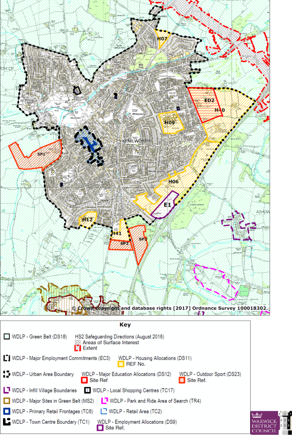
Map 3.1: Warwick Local Plan Extract Policies Map 5 Kenilworth
3.8 The new Local Plan contains four 'strategic' policies (DS1 – DS4) that set out the essential spatial principles of the plan. Of these, DS4 has the most importance for the Neighbourhood Plan in shaping where and how new homes and employment will be delivered.
3.9 Thereafter, there is a range of policies that have some strategic intent and the following are considered to be the most relevant for Kenilworth:
- DS9 Employment Sites to be Allocated – including 8 Ha of new land at Kenilworth for B1 and B2 uses
- DS10 Broad Location of Allocated Housing Sites – which identifies 1,593 homes on the edge of Kenilworth as part of its wider strategy
- DS11 Allocated Housing Sites – including 250 homes on the Kenilworth school site (H09), 130 homes on the Kenilworth VI Form College (H12) and 100 homes on land east of Warwick Road (H41)
- DS12 Allocation of Land for Education – makes provision for the relocation of the existing secondary school provision in the town to the strategic development land east of the town
- DS18 Green Belt – listing the areas in Kenilworth which have been removed
- DS 23 Allocation of Land for the Provision of Outdoor Sport - land at Castle Farm (SP1), and Land at Warwick Road (SP2), Kenilworth are allocated for the provision of outdoor sport
Non- strategic Policies
- EC1 Directing New Employment Development
- EC3 Protecting Employment Land and Buildings
- TC1 Protecting and Enhancing the Town Centres – Kenilworth Town Centre is defined
- TC2 Directing Retail Development – relating to Kenilworth Town Centre
- TC6 Primary Retail Frontages – defining the frontage in Kenilworth Town Centre
- TC7 Secondary Retail Areas - defining the area in Kenilworth Town Centre
- TC17 Local Shopping Centres – identifying High Street, Leyes Lane, the Oaks Precinct and Albion Street in Kenilworth
- CT1 Directing New Meeting Places, Tourism, Leisure and Cultural and Sports Development
- CT2 Directing New or Extended Visitor Accommodation
- H2 Affordable Housing – requiring 40% on sites of 11 homes or more
- H4 Securing a Mix of Housing
- BE1 Layout and design
- TR1 Access and Choice – details access issues by all modes of transport including pedestrians
- TR2 Traffic Generation – requires Transport Assessments and consideration of air quality
- TR3 Parking – refers to the Parking Supplementary Planning Document
- HS2 Protecting Open Space, Sport and Recreation Facilities
- HS8 Protecting Community Facilities
- HE1 Listed Buildings
- HE2 Conservation Areas – identifying the four Areas in the town
- HE4 Historic Parks and Gardens – identifying the Castle as a listed asset but also Abbey Fields, Parliament Piece, Rudfyn Manor and Wantage in the town as of local interest
- HE5 Locally Listed Historic Assets – on a list that has yet to be prepared
- NE1 Green Infrastructure
- NE2 Protecting Designated Biodiversity and Geodiversity Assets
- NE3 Biodiversity
3.10 This combination of policies provides a reasonably clear steer for the Neighbourhood Plan but leaves some issues unaddressed. Notably, the new plan makes no provision for expanding the town centre offer to encourage and enable the larger population to spend within the town. Nor does it consider how patterns of access and movement across the town may be affected by these major spatial changes.