Canal Conservation Area
Documented History
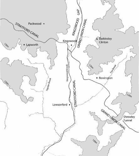
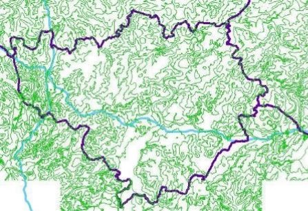
The District is 28,226 hectares of land and probably the furthest district from the coast. The main river system that passes through the District is the River Avon and its tributaries the Leam, Sowe and Finham Brook which flow through and meet in Warwick District. The river system comes from the north and east and flows out south and west, through Leamington and Warwick towards Stratford-upon- Avon and then the River Severn. The watershed for the Birmingham plateau occurs around Packwood, where streams fall north toward the Trent.
In Warwickshire early contour canals like the Oxford Canal were followed by straighter canals with locks and tunnels at the end of the eighteenth century. Soon a network was crossing Warwickshire that largely continues to exist today. Older industrial estates are found closer to the town centres where the canals and railways pass through the towns, with the bigger more recent post war industrial estates being on the edge of the settlements. Many rail lines closed in the 20th century, with dismantled railway lines still a feature in the landscape such as at Radford bottom lock, part of the disused Leamington – Rugby line and above Lowsonford, a part of the Henley in Arden Branch. The mainline railway follows a similar route to the Warwick and Birmingham canal crossing it on the way into Leamington and under on the way out.
When railways were developed in the mid nineteenth century, Warwickshire was again a crossroads between London and Birmingham, with lines linking Coventry, Rugby, Leamington Spa and other major towns. The railway network in the District has Leamington as the hub with links to London, Birmingham, Coventry and through to Stratford via Warwick.
The turnpike roads from Warwick to Northampton and to Birmingham and from there to Stratford were improvements in the 18th century.
The M40 passes through the south and south western part of the District where it crosses the Stratford upon Avon Canal.
There is an above average amount of woodland in Warwick District, one of the main areas being Hay Wood to the east of Baddesley Clinton and the Grand Union Canal. A large amount of piecemeal enclosure with its irregular fields and curvilinear boundaries is one of the dominating characteristics in the western part of Warwick District.
ref drawn from Warwickshire Historic Landscape Characterisation
Taken from Dyos.
Around 1636-9 Sir William Sandys had carried out improvements to the River Avon to overcome some of the difficulties river navigation present. These included side cuts with pound locks to secure water supply.
In the 18th century the River's Severn and Avon provided water transport to Stratford from Bristol, while coaches and wagons travelled the rudimentary roads between the towns of Birmingham, Warwick and Stratford. Canals work better the rivers, as they could go where rivers did not go and could be kept under control in regard to water supply without the drawback of floods and droughts, or being silted up. Canals were not always welcomed,, with landowners often taking sides. When the Duke of Bridgewater applied for the powers to construct his second canal, the existing river navigation users petitioned against it. Active opposition was also offered by landowners whose property was either used for the Canal or believed it will deteriorate in value. Change was perceived as threatening interests. The beneficial effect of canals on Manchester's and Liverpool's trade was considerable, instead of going via Bridgnorth and the Severn to Bristol, it enabled Manchester manufacturers to get their raw materials direct from Liverpool and to supplement the coal at a cheaper price they were already getting from Worsley. The Port of Liverpool was opened to a wider stretch of the country. The Manchester and Runcorn Canal followed on from the Duke of Bridgewater's project for taking the Worsley coals to Manchester by Canal.
These initiatives attracted investment. Between 1758 and 1803 when Phillips wrote his general history of waterways, no less than 165 acts of parliament for cutting canals at a capital expense of over £13 million was subscribed by private individuals, and the length of Canals so proposed was 2896 miles/ km Brindley's Trent and Mersey Canal was supplemented by the Wolverhampton Canal now part of the Staffs and Worcester canal, connecting the Trent with the Severn. The Birmingham Canal and the Coventry Canal gave through navigation from the Trent at Lichfield and the Oxford canal to the Thames; these were major changes to the infrastructure of the country.
Wedgwood's improvements to the pottery industry were held back by effective communications. The roads were hopelessly bad and navigable rivers were distant, it was also difficult to get clay at a suitable cost and the risk of damage involved in long planned journeys to the London or to the continent almost closed these markets to the Staffordshire manufacturer. As a result of the waterway, Wedgwood was able to say to a House of Commons committee in 1785, that he had increased the number of workers from around 7000 to 20,000, work was abundant and that this enhanced prosperity.
A quote from Williamson's Liverpool advertiser in 1777 shows that compared with the £5 per tonne transport from Liverpool to Birmingham by road, this was reduced to £1.50 by water.
Canal infrastructure, accompanied a number of inventions and improved processes to leading industries brought about the industrial revolution, with the improvements in inland communication, together with shipbuilding and the art of navigation making foreign markets accessible. James Watt's condensing steam engine, patented in 1769 and further improved in 1781, took the place of water power from rivers and streams. It was used for the operation of cotton machinery which consequently changed from a domestic trade to the factory system.
This industrialisation depended on the abundant supply of coal and the means to move the coal from where it was mined. England on the eve of the greatest industrial expansion of any country in Europe needed canals for better trade, more employment, higher wages, cheaper fuel and less of the isolation which many landlocked communities had suffered. Ref source - Pratt History of inland navigation 1912
The Canal Conservation Area celebrates the new approaches to engineering developed in Britain during the Industrial Revolution and taken up in subsequent waterway, railway and road construction throughout the world. The engineers intervened in the landscape with a new scale and intensity, challenged by the need to cut a waterway across the grain of the topography. These waterways have remained in use continuously for over two hundred years, with traffic in coal, iron, limestone, timber and general goods, and in more recent times to carry pleasure boats .
All of the features that were to become characteristic of highly- engineered transport routes can be seen in the works, including tunnels, cuttings, aqueducts and embankments of monumental scale, together with bridges, culverts, weirs and associated features. The Aqueduct over the Avon and Rowington Cutting and Embankment are monuments of the Canal Age in the United Kingdom, which flourished from the 1760s until the establishment of a network of locomotive railways from the 1830s.
Hatton flight rises 146 feet out of the Avon valley and in its' construction of Broad Locks alongside in the 1930's represents the partnership of government measures to deal with employment , and private initiatives to complete a network that widened the transport options between London and Birmingham, prior to the railway companies fifty years later and the M1 opening in 1959. The Stratford Canal has a unique collection of lock houses and heel bridges. The District's canals are widely valued for their historical importance, beautiful environment and structures, and attract locals and visitors alike to their peace and tranquillity, a world apart as one local called them at a recent event.
The construction of a network of canals in Britain to provide transport for raw materials and goods represented a new phase in the history of inland navigation and was a fundamental factor in the Industrial Revolution, enabling and promoting rapid economic growth, regional specialisation and urbanisation. The Warwick Canals were a key part of that network. Canal-building reached its zenith after 1790, during the so-called 'Canal Mania' that saw 1,900 kilometres of new waterway completed in just twenty years. It contributed to wider developments in business organisation, capital mobilisation and engineering technology which were then applied to construction projects everywhere. The development of joint-stock companies to raise capital from numerous small investors, the creation of effective contracting teams, and the development of new engineering techniques and materials and the profession of Civil Engineering that was maturing in Britain in the late eighteenth and early nineteenth centuries.
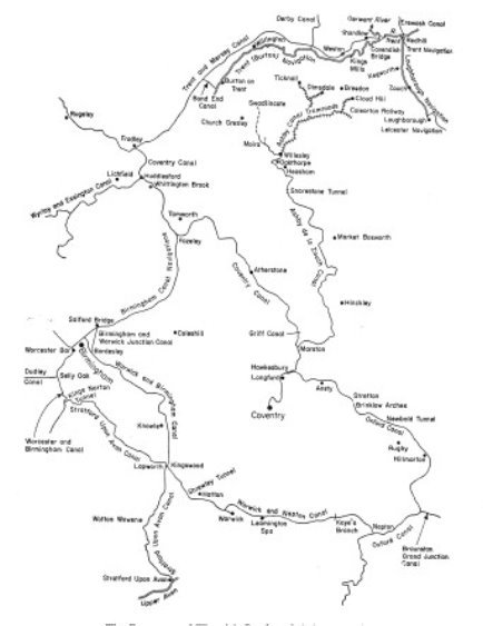
WATERWAYS THROUGH THE MIDLANDS
The canal historian, Charles Hadfield, calculated that some 58 kilometres of canal tunnels had been constructed in Britain by the time that the network reached its peak in the mid-nineteenth century, and that this was far more than the total in the rest of the world at that time.
The Duke of Bridgewater's Canal set the legal precedent of
compulsory purchase of land by Act of Parliament, assisting
canals to cross the lands of multiple owners. Popular
shareholding by many small investors was spearheaded by canal
companies, enabling a scale of capital investment that otherwise
would have been inconceivable: canals introduced the better off
to the marketable company share and became by far the largest
concentrations of capital in the Industrial Revolution.
The waterways system that developed in Britain between the 1760s and the 1830s can be regarded as a new beginning in inland transport that was driven by the needs of industrialisation and private enterprise, springing from the canal built at Manchester by the Duke of Bridgewater in 1761. During the next thirty years, canals linked the four principal river estuaries of southern Britain. The feverish speculation in shares of the Canal Mania in the 1790s resulted in many more projects, Warwick and Birmingham, Warwick and Napton, as well as Stratford Upon Avon Canal among them.
The Warwick Canal Corridor is a continuous, linear historic place 40 kilometres long, as a visible representation of the improvement of transport during the Industrial Revolution. It contains the engineering features of the canal, its construction and historical operation, and the immediate visual surroundings that can still be appreciated in its landscape setting.

UNIQUE LOCK COTTAGE CONSTRUCTION BW200
The route was planned before relief maps were available, and success depended entirely on the engineers' own explorations, levelling surveys and distance measurements. The demands of powerful landowning interests also provided challenges.
The George III act said thirty yards was allowed for the works and deviation of the line approved could be up to one hundred yards.
The scale and form of the canals are typical of those built in Britain during the early Industrial Revolution. Their form is essentially the channel, a flat towing-path for the horses that drew the boats, hedges to separate the towing-path from adjacent fields, and any wider land needed for embankments and cuttings. The majority of the formation is as it was built, apart from that altered in the 1930's or diverted to allow the construction of Europa Way on the Grand Union.
The channel was dug and waterproofed in clay by gangs of navvies, using picks and shovels and wheelbarrows on runs of planks. A rammed layer of 'puddled' clay was used for waterproofi ng, except in impermeable conditions such as bands of naturally-occurring clay. Some of the canal lengths are constructed on embankments, free- standing earthworks crossing valleys and depressions. Others are terraces with cuttings on one side and embankments on the other to support the canal on slopes.
The first widely-known iron bridge, in what is now the Ironbridge Gorge World Heritage Site, demonstrated the constructional possibilities of cast iron when it was built in 1789. This and Longdon- on-Tern Aqueduct, built by Telford in 1796, are of importance as experimental structures. The South Stratford-upon-Avon Canal of 1813 has iron aqueducts in the adjacent Stratford District, whereas the Horseley iron works one at Yarningale, was built to replace an earlier masonry structure. The cast iron troughs that still carry the Warwick and Napton length over the mainline railway at Myton, show the success of these experiments.
A collection of Warwickshire citizens saw an opportunity to connect the growing manufacturies of Birmingham with the City of London through Warwick with a connection to Bristol via the Warwickshire Avon at Stratford and the River Severn.
BIRMINGHAM PLATEAU 120M CONTOUR SHOWING CANAL ROUTE REB
There were issues of topography that were a challenge, alongside those of obtaining powers from Parliament. The city of Birmingham stands on red sandstone some 300 feet above sea level and a distance from the navigable rivers. The Warwick to Birmingham canal had to be built to overcome the ridges of hills, obstacles between the two towns. This was achieved by locks and with the cutting at Knowle, a cutting at Rowington, followed by a long embankment , and a wide short tunnel at Shrewley. The later railway following a similar route, engineered some wider cuttings through these same ridges, as can be seen from the OS plans.
There is a watershed at Lapworth and Rowington from which the rivers Alne and Arrow flow south towards the River Avon. The Warwick and Birmingham canal (now part of the Grand Union) descends into the Avon Valley by the Hatton flight of locks into Warwick. The Warwick and Napton Canal then crosses the River Avon on aqueduct (built at the same time as the new Castle bridge for the Earl of Warwick). Later an aqueduct was constructed by the railway company to carry the Warwick and Napton canal over the new railway. The Leam, a tributary of the Avon, flows west from Braunston, and the Warwick and Napton canal survey originally aimed to follow a similar route to Braunston in Northamptonshire, however the shorter link to the Oxford canal which avoids major earthworks or more aqueducts being constructed was found, and a new act of Parliament obtained.
When the proposed Warwick and Birmingham Canal was proposed to pass within 8 miles of Stratford-upon-Avon, local businesses realised that a connection to this new form of transport would be beneficial. On 28 March 1793 an act of Parliament was passed for the construction of the Stratford-upon-Avon Canal starting at Kings Norton on the Worcester and Birmingham Canal 3 miles from where that Canal connected with the Dudley Canal, giving a direct link to a major coal producing area. The total estimated cost of the complete Canal was spent in the first three years on cutting the ten lock free miles to Hockley Heath (including the 352 yard Kings Norton tunnel). By 1802 the canal was open from Kings Norton Junction to its junction with the Warwick and Birmingham Canal near Lapworth.

KINGSWOOD JUNCTIOS LISTED STRUCTURES BW200
Work started in 1812 under William Whitmore as engineer on the southern section and the connection with the River Avon at Stratford where the river was navigable down to the Severn at Tewkesbury.
This was completed in 1816. At its' busiest the canal's annual traffic included 50,000tons of coal and 180,000 tonnage overall.
East of Hockley Heath the canal descends through the Lapworth flight. A tributary of the River Alne passes close alongside for several miles. Often large clumps of reeds on the offside may conceal a nest for morhen , the most common water bird on the canal. Bridges on the northern section are usually brick arches, with the split bridges mainly being on the southern section . The first lock is west of Packwood house, it is known as lock2,
The stop lock at the junction being lock 1. Packwood House is a National Trust property half a mile from the canal, it is a 16th century timber framed house enlarged in the 17th century by John Featherstone. It has a famous Yew garden. From here there are 55 locks down to Stratford. The Lapworth flight is nine locks, each close to its neighbour, the short intervening pounds provide a bigger working reservoir of water to each lock on the flight. The heel gates are double. At lock 19 is Kingsford junction where a short branch to the left to lock 20 leads under the main railway to the Grand Union Canal.
The two Warwick canals now the Grand Union) were open to trade from Birmingham to Napton on the Oxford Canal in 1800, the same year the Grand Junction Canal opened from Braunston to Brentford with a temporary railroad across Blisworth Hill. By 1805, when the Grand Junction was finally completed, the county town of Warwick was at the heart of a major new waterway from the industrial Midlands to London. The Warwick and Birmingham canal ascended locks from Digbeth, Camp Hill Bordesley at its' northern summit and then descended by many narrow locks to the Avon Valley. The company had to build a reservoir at Olton to supply water to the summit level. They had the backing of the Birmingham Canal Company, but still had to pay tolls to them for making the junction at Digbeth.
The Warwick and Napton Canal descended from Napton by narrow locks to the Avon valley, not only did the canal company have to pay compensation tolls for joining the Oxford Canal and to rely upon it for water supplies, they soon had to meet the cost of building Boddington reservoir on the Oxford canal and to build reservoirs at Napton.
CANAL ROUTES THROUGH WDC LANDSCAPE SHOWING CONTOURS
In 1838 the London and Birmingham railway opened. When in 1845 the Warwick canal companies were put in the hands of the receiver, the London and Birmingham railway company offered to buy the Warwick canals in order to lay a branch through Daventry to Leamington, but negotiations floundered.
The railway boom or mania in 1845 saw the Oxford, Worcester and Wolverhampton railway planning its lines and it offered to buy the Stratford-upon-Avon canal. The sale was eventually completed in 1856 and three years later the railway company bought the Upper Avon navigation.

CANTILEVERED SPLIT BRIDGES BW200
In 1846 the London and Birmingham railway was combined into the London and North Western Railway.. A Birmingham and Oxford railway was authorised in 1846, this was taken over by the broad gauge Great Western Railway in 1848. The railway followed close by the route pioneered by the canal between Birmingham and Warwick. The Stratford-upon-Avon and Hatton branch was opened in 1860, so, by 1863, the Great Western Railway controlled all the water and rail routes to Stratford and the southern section of the Stratford-upon-Avon canal was allowed to gradually decay.
The opening of the Stratford canal's junction with the Warwick line at Kingswood had enabled trade to the Dudley canal and that Canal Company became accustomed to making joint arrangements with Worcester and Birmingham and Stratford Canal for reduced tolls, to keep as much traffic originating on the Dudley as possible. Lord Dudley who together with his predecessor had been instrumental in the Dudley canal, resigned from the canal companies committee when the canal opened, but exercised influence through his mine agents. At times Lord Dudley's quarries at Parkhead and Bumblehole struggled to meet the increasing demand for coal. In 1839 Lord Dudley's trustees built the Pensnett canal to serve Round Oak and other ironworks belonging to the Lord.
From Kingswood Junction, the canal continued south through locks, often with split bridges over to allow the tow line through .The unusual barrel roofed cottages which are a feature of this canal have been adapted and in some cases extensively extended to suit the new owners. The roof is a mixture of brick, rubble and lime mortar, covered in asphalt. These owners include the Landmark trus,t who have a property they lease out and recently an Antony Gormley sculpture was sited here. At Yarningale, Wooten Wowan and Bearley there are cast iron aqueducts, another unusual feature.
William James had spent a considerable amount on the canal and river navigation., An engineer, he proposed a Central Junction Railway or an extension of his tram road from Stratford-upon-Avon to London in 1822, he then made surveys between Liverpool and Manchester that in 1824 resulted in the Liverpool and Manchester Railway Company being formed. Whilst the first Liverpool and Manchester bill was thrown out in 1825, it was passed in 1826, due to the Bridgewater navigation's trustees having been given 1000 shares in the railway.
At this point, although horses were out of the question, they seemed divided as to whether to use locomotives or stationary engines every mile or two along the line to draw the trains by means of ropes. To find the best solution stop they offered a premium of £500 for a locomotive which would do the work. George Stephenson won the prize with his Rocket , with a gross load of 17 tons, ( half a narrow boat's) it attained a speed of 29 miles an hour and an average of 14mph. This was well in excess of the 6 or 7 miles per hour sought by the promoters.
Originally intended to allow any one to run their own engine on the railways, the Royal commission of 1865 summed up the position, "no sooner were railways worked on a large scale with locomotive power and it was found impracticable for the general public to use the line with carriages and engines and railway companies were compelled to embark on the business of common carriers on their own line and conduct the whole operations". They have remained a closed network, compared to the open access to Canals. The Conservation Area should promote the association with James.
NARROW LOCKS KEPT TRADE GOING DURING CONSTRUCTION BW200
By the end of the nineteenth century,, the Grand Junction Company was seeking agreements and amalgamations with other canal companies to improve their position against railway competition.
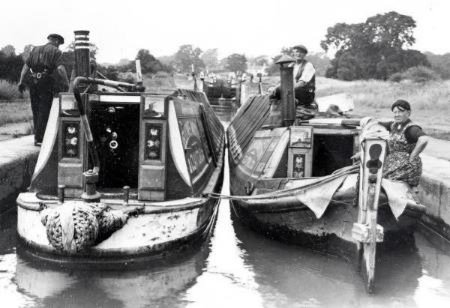
Eventually the Regents Canal, with the two Warwick canals became part of this, the Grand Union Canal in 1929. Major improvements followed in the 1930s with the construction of new wide locks between Braunston and Bordesley and new warehousing at Birmingham. The waterway as improved can be seen today, together with the remains of the narrow locks which were planked over and used as weirs alongside the new broad gauge locks. The locks were widened and opened in 1934. All locks between Knowle and Calcutt have the distinctive worm and nut paddle gear installed as part of a modernisation programme in the 1930s. The castings are by Ham Baker and co. whose office was in Westminster SW as marked on the paddle gear casing, but the castings were made in Birmingham.
The company spent over a million pounds on improving the waterway along this main route between Birmingham and London. The journey from Birmingham to London can be accomplished in something like 50 hours and the time had become much more predictable, so that effectively waterborne freight was like having a floating warehouse. It was argued that canal transport has many advantages. Even the most fragile merchandise can be carried with certainty the canal boat had a much greater capacity than a railway track or than a lorry and was as cheap, efficient and reliable. The Royal Commission report into government in December 1930 said,' we are at that of the opinion that certain canal still possess considerable value as a means of transport… Commodities such as coal, are unsuitable for conveyance by road, canals are the only practical alternative to the railways, whilst for… Pottery, they offer much less risk of damage than either road or rail…..Factories could be erected at any convenient point on the canal banks, and goods can be transferred direct from factory to barge without interfering with through traffic……The Minister of Transport should take steps to set up public trusts, which will acquire such canals as he considers it would be in the national interest to preserve and improve"

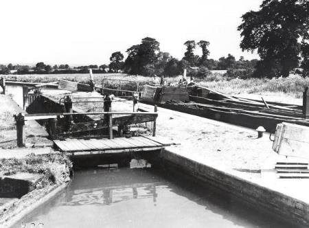
TOP OF HATTON FLIGHT UNDER CONSTRUCTION BW200
The Grand Union 1930s investment.
A comprehensive scheme of development to accommodate increasing volumes of traffic was carried out. The old narrow locks replaced by wide ones to enable the narrowboats to travel through in pairs or wider craft. From Stockton at that time the centre of the cement industry and also a large area devoted to the manufacture of bricks and tiles thousands of tons of building products passed annually. In the Leamington area large quantities of coke breeze, tar and grain were handled by canal. There were numerous works handling all types of goods, particularly grain and timber at BudBrooke wharf at the junction with arm into Warwick and the Saltisford wharves. On the south side of the canal from Cape wharf there was Packmore's wharf, Union wharf, Guys Cliffe Wharf , Hill wharf Emscote old wharf and Emscote new wharf, Emscote Mills, operated by Kench and Sons Ltd, on the north of the canal , Myton road wharf serving the Leicestershire and Warwickshire Electric Power Co Ltd.,
Leamington followed with a wharf served the Midland Electric light and Power Co Ltd and the Leamington gasworks. At Eagle wharf there was Sydney Flavel and company and the Leamington Corporation. There was a basin at Clapham Terrace's and 800 m away Gullimans wharf, followed 2 km to the east by Butt Lane wharf, Fosse wharf, OffChurch and Longhole wharf. Local trade was also served by Bascote wharf, and Cuttle wharf, at Long Itchington. Rugby Portland cement and the Allied brick and tile company used a wharf at Birdingbury ,with Stockton being the location for Charles Nelson and companies trade.
As well as the improvement works executed by contract, the Grand Union company established six depots between London and Birmingham where reinforced concrete sheet piles were made by direct labour. The Warwickshire Depot had an output of between 400and 500 piles per week. These were surmounted by a coping formed in mass concrete 300mm deep, extending 400 mm back from the water's edge. The irregular boundaries of the canal were replaced by concrete walls to allow higher speeds between locks.
Over half a million pounds worth of improvements were spent on the Warwick portion. Starting in 1932, Between Napton Junction and Knowle, there were 51 new wide locks, now 4.6 m wide at coping. The work being carried out with interruption to traffic on the canal. From Knowle to Hatton there is a pound 8 miles long and then a fall of 147 feet or 44.8 m in 21 locks and a further two locks Cape dropping 4.37 m to the level that runs through Warwick district with overflow weirs to the Avon and Leam rivers as far as Offchurch/Radford lock where it starts to climb again.

REINFORCED CONCRETE REPLACEMENT BRIDGE BW200
An important part of the construction were new reinforced concrete bridges. Hatton Hill bridge is 3.96 m between parapets and has a span of 13.72 m. Middle lock bridge was only 1.8 m between parapets but had a span of 17.1 m .Three new reinforced concrete bitch bridges were built by Messrs Speight all 6.1 m between the parapets and over 15 m span except for the greed bridge which bands are only just over 11 m and had to be founded on reinforced concrete piles owing to a pocket running sand. The construction of these bridges is portals 600 wide and 525 mm deep with a 390 mil slab over the beams this was waterproofed by 20 mm of felt and topped with 100 mm of the parapets were cast in situ 1200 high and 300 wide in a distinctive detail. Below the metre wide footpath lies a pipe duct. The bridges were designed with just over 3 m clearance from the water level, to serve the public road traffic of the time

DUKE OF KENT OPENING THE IMPROVED CANAL 1934 BW200
The Grand Union company had a large trade in the carriage of cementing bags, traffic particularly well-suited to carriage by water it was loaded and discharged under cover in special warehouses redelivery by road in small lots whilst: Roadstone could be sourced through the company and supplied at relatively short notice. There was a through route from the continent to the Midlands. A steamer discharging iron and steel in the Regents Canal docks directly to boats placed alongside from whence they travelled to the Birmingham terminal. The link from Warwick's canals to the Regents Canal Dock in the port of London made it possible to ship goods by water from Europe and America.

GU HATTON FLIGH BW200
In the period after 1850 Britain was commonly called 'the workshop of the world' owing to its success in industry, but in the same period there was a tendency to disparage industry and to see the nation's history in terms of medieval churches and great mansions. LTC Rolt's highly influential book Narrow Boat (1944) had begun to create new interest in the canals and he had co-founded the Inland Waterways Association, a pressure group for the retention of the canal system. Popular interest in the canals had been stimulated by the pioneering documentary drama fi lm, Painted Boats (1945). It was whilst on a visit to Stratford , and after a morning walk up the canal, that the pioneer Robert Aickman, who founded the IWA, was prompted to start the campaign for their restoration and use.
BW200
Most places we value evolved over time and can continue to be valued if by study we can provide an informed approach to understand the impact of change, assess potential harm and how it might be mitigated and also develop a shared stewardship so that future proposals are not prejudiced through short term decisions and the loss of value and integrity.
Understanding potential consequences through a clear accessible analysis is the best way to shape proposals, compare options, recognise reversible interventions and articulate the enduring significance of a place.

CAPE OF GOOD HOPE POST WAR BW200

Sensitivity of historic places can be worked out by the capacity to accommodate change without undue harm to the significance. Their evolution and cultural significance needs to be presented in a way that then informs both the proposal and the assessment of its acceptability.
Respect is an oft use word, this does not lie in conformity but with what is compatible, what is generated by an understanding of the intentions and characteristics behind what exists already of value, and then how that might be best enhanced or developed for future generations. Heritage as a continuum rather than finite.
Defining character beyond describing appearance now, looking back over fifty years and forward to understand a lifetime of how places change and how they may be designed to get the best out of the inherited landscape, the open spaces like the canal and sustain the historic structure.