Bishop's Tachbrook NDP Regulation 16 Submission
(5) 4.0 Key Issues
4.1 This section sets out the key issues facing Bishop's Tachbrook based on the policy assessment and evidence base and those raised during consultation.
New Housing in the Bishop's Tachbrook neighbourhood area
4.2 Warwick District has a growing, ageing, ethnically diverse and highly skilled population. 90% of residents live in the towns of Kenilworth, Warwick, Whitnash and Royal Leamington Spa, with the remaining 10% living in a number of relatively small villages, such as Bishop's Tachbrook.
4.3 The district's population grew by 11% from 124,000 in 2000 to 137,700 (2011 Census) and is forecast to continue to grow by a further 26% between 2011 and 2029. Notably, the highest rate of population growth is expected to be amongst those residents who are aged 65 and over.
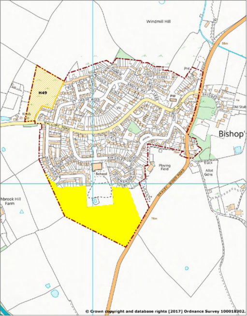
4.4 The majority of the district's rural area lies within the West Midlands Green Belt, with the remaining land south of Warwick, Whitnash and Royal Leamington Spa not benefitting from this protection. Bishop's Tachbrook Parish is central to this non Green Belt area. The Warwick District Local Plan identifies new housing land in the village (Map 4, page 22) and significant housing development in the north of the neighbourhood area (Map 5, page 23).
4.5 The BTNDP will, therefore, not look to identify further sites or change the growth village envelope. These should remain unchanged and be used to manage any proposed housing growth to 2029. The BTNDP will, however, look to influence the type and mix of new homes built in the area in the next 10 years.
4.6 The Warwick Local Plan also plans for new housing and infrastructure in the neighbourhood area shown on Map 5 (page 23). The sites are:
- H02 Land south of Harbury Lane (Grove Farm and Lower Heathcote Farm) – 1605 homes
- HO2 Land south of Harbury Lane (Former sewage works - brownfield site) - 215 homes
- H46B The Asps – 900 homes
Many of these homes are already constructed and occupied, further construction carries on at a steady pace. This is bringing many new residents into the Bishop's Tachbrook neighbourhood area and is leading to pressure on services, roads and amenities, such as the neighbourhood area's countryside. It is important that such impacts are managed to ensure they are sustainable and have some benefit to existing and future residents of the neighbourhood and wider area.
4.7 It will be important for the distinctiveness, character and natural and built environment (including Tachbrook Mallory and the area's parks and gardens) that the separate, physical identify of Bishop's Tachbrook village is maintained.
4.8 To a degree, the creation of Tach Brook Country Park will provide both a buffer separating Bishop's Tachbrook village from the southern boundary of Royal Leamington Spa; and create open land and a recreation resource that will be used by both the village and town communities (Map 5, page 23).
Map 4. Warwick District Local Plan, Bishop's Tachbrook village inset (Source: Warwick District Local Plan)
Key to Maps 4 and 5
 WDLP - Housing Allocations (DS11)
 WDLP - Major Housing Commitments (DS7) WDLP - Growth Village Envelopes (H10)
Map 5. Warwick District Local Plan, Proposals south of Royal Leamington Spa, including Tach Brook
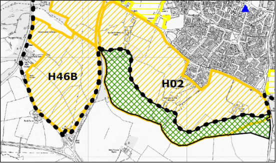
Country Park (Source: Warwick District Local Plan)
Greenspaces and Tach Brook Country Park
4.9 The neighbourhood area's population will increase significantly in the coming years, this will place pressure on existing greenspaces and open land resources. The BTNDP will seek to protect existing key open land and greenspaces.
4.10 Given the growing population the BTNDP will also seek to extend the range of open and green spaces and the access to these spaces, particularly the new Tach Brook Country Park. The new Warwick Local Plan sets the strategic planning policy for this site through Policy DS13 Allocation of Land for a Country Park.
DS13 Allocation of Land for a Country Park
4.11 Land adjoining the Tach Brook is allocated for a Country Park (Map 5, page 23). Based on the explanatory text in the Local Plan this area will be:
- a multifunctional green infrastructure asset to:
- Provide a strong 'green buffer' between the northern parts of Bishop's Tachbrook and the southern edge of the new development sites off Harbury Lane. This will include minimising the visual impact of development and softening the edge of new housing schemes.
- Promote ecology and habitat diversification in a landscape that has historically been associated with modern farming and other uses.
- Potentially play a role in flood alleviation, particularly considering the close proximity of a significant numbers of new houses.
- Provide a functional park facility that is well-connected to new developments, in terms of access and walking and cycling infrastructure. While the park may have a defined character, it is also part of a wider brook valley / green corridor.
- Provide park facilities of an appropriate scale to support informal leisure activities for people living within the wider area south of Leamington / Warwick, who currently have limited access to nearby natural green space and the wider countryside.
Community and Recreation Facilities
4.12 Central to the health and well-being of any community are the local community facility and formal recreation facilities available to that community. The BTNDP will seek to protect existing community facilities (e.g. shops, pub, halls etc.) and existing formal recreation spaces (e.g. playing pitches and allotments) across the neighbourhood area.
4.13 The BTNDP will also look to ensure that community and recreation facilities are accessible to all sections of the community and that these resources are a means of bringing the village and town communities together.
Landscape
4.14 Bishop's Tachbrook lies within Natural England's National Character Area (NCA) NCA96: Dunsmore and Feldon.The Dunsmore and Feldon NCA is a predominantly rural, agricultural landscape, crossed by numerous small rivers and tributaries. The BTNDP will seek to protect this landscape, particularly those areas identified as highly sensitive to future housing development.
Heritage
4.15 The BTNDP area has a number of designated heritage assets e.g. the 32 listed buildings (Appendix 2). In addition to these buildings that already have a high degree of protection the area also has a number of non-designated heritage assets and we will seek to protect these in accordance with their significance.
The future
4.16 The Parish Council is aware that the BTNDP, when adopted, will set the planning policy framework for the area in conjunction with the Warwick District Local Plan. Together they set policies against which planning applications will be assessed and, unless there are other material considerations, whether they will be approved or not. The Parish Council are committed to developing a masterplan focussing on the coordinated delivery of green and community infrastructure improvements and the means by which to deliver them. The masterplan will lay out the economic, environmental and social benefits of specific projects and how these might be weighed against any negative impacts of either the improvements or the means identified for bringing forward such improvement. The masterplan will be advisory in planning terms, but it will be important in setting out a vision for the future of the parish in a period of significant change. The masterplan will be subject to necessary and appropriate public consultation. To give the masterplan, or parts of the masterplan, greater weight in planning terms, it may be necessary to review the BTNDP and include masterplan proposals in an updated plan.