Skip to main content
Login
|
Register
Home
Consultations
Preferred Options
Appendices
Preferred Options
Ended on the 3rd August 2012
Search representations
Search representations
1. Introduction
2. Our Vision for the District
3. The Local Plan Process
4. Spatial Portrait, Issues and Objectives
Population and Spatial Portrait
Issues
Objectives
5. Preferred Level of Growth
PO1: Preferred Level of Growth
Justification for Preferred Option
National, Regional and Local Policy
What is the Evidence to Support Different Levels of Growth?
What are the Options?
6. Community Infrastructure Levy
PO2: Community Infrastructure Levy
7. Housing
Introduction
Relevant Issue & Strategic Objectives
PO3: Broad Location of Growth
Justification for Preferred Option for the Broad Location of Growth
Other Options
The Location of New Housing
TABLE 7.1 Housing to be Allocated in the Plan
TABLE 7.2 Distribution of Housing
PO4: Distribution of Sites for Housing
A. Allocated Sites
Within the Urban Areas
On the Edge of Warwick, Leamington Spa & Whitnash
On the Edge of Kenilworth
B. Category 1 and 2 Villages
Category 1 Villages
Category 2 Villages
C. Development on Brownfield Land
Category 3 Villages
D. Development on Greenfield Land
Chart 7.1 Housing Trajectory
Justification for Preferred Option for the Location of New Housing
Other Options
Meeting the Need for Affordable Housing
PO5: Affordable Housing
A. Affordable Housing on Housing Development Sites
B. Affordable Housing on Rural Exception Sites
Justification for the Preferred Option for the Provision of Affordable Housing
Other Options
Mixed Communities and a Wide Choice of Homes
PO6: Mixed Communities & Wide Choice of Housing
Justification for the Preferred Option for Mixed Communities and a Wide Choice of Homes
Other Options
Gypsies and Travellers
PO7: Gypsies & Travellers
Justification for Preferred Option - Gypsies and Travellers
Other Options
8. Economy
Introduction
Relevant Issue & Strategic Objectives
PO8: Economy
Justification for Preferred Option
National Planning Policy Framework (NPPF)
Draft Economic Development and Regeneration Strategy 2012 to 2017
Coventry and Warwickshire Local Enterprise Strategy (LEP) 5 year plan (2011 to 2016)
Developing the Employment Land Requirement and Supply
Location of employment land
Protecting Existing Employment Land
Supporting Economic Growth
9. Retailing and Town Centres
Introduction
Relevant Issue & Strategic Objectives
PO9: Retailing & Town Centres
Justification for Preferred Option
National and other policy context
Ensuring the vitality of town centres
Warwick District Retail and Leisure Study (May 2009)
Future Retail Capacity Estimates for Warwick District
Other Options
10. Built Environment
Introduction
Relevant Issue & Strategic Objectives
PO10: Built Environment
Justification for Preferred Option
Other Options
11. Historic Environment
Introduction
Relevant Issue & Strategic Objectives
PO11: Historic Environment
Justification for Preferred Option
Other Options
12. Climate Change
Introduction
Relevant Issue & Strategic Objectives
PO12: Climate Change
Preferred Option: Achieving Sustainable Buildings
Preferred Option: Planning for Renewable energy and Low Carbon Generation
Preferred Option: Climate Change Adaptation
Justification for Preferred Option
National Planning Policy Framework (NPPF)
Renewable and Low Carbon Energy Resource Assessment and Feasibility Study (2010)
Warwick District Low Carbon Action Plan (2012)
Climate Change Adaptation Study 2011
Explanation and Other Options
Reducing carbon emissions
Achieving Sustainable Buildings
13. Inclusive, Safe and Healthy Communities
Introduction
Relevant Issue & Strategic Objectives
PO13: Inclusive, Safe & Healthy Communities
Justification for Preferred Option
National and other policy context
Core planning principles
Requiring good design
Promoting healthy communities
Evidence Base
Levels of crime and disorder in Warwick district
2011/12 priorities
A District with low levels of 'Multiple Deprivation'
Multiple Deprivation in Warwick District
Warwick District Parks and Open Spaces Audit 2008
Other Options
14. Transport
Introduction
Relevant Issue & Strategic Objectives
PO14: Transport
Access to services and facilities
Preferred Option: Sustainable forms for transport
Preferred Option: Provision of Transport infrastructure
Preferred Option: Parking
Preferred Option: Rural Transport
Preferred Option: High Speed 2 Rail Line
Justification for Preferred Options
National Transport Policy
Warwickshire Local Transport Plan 2011-2026
Research and Consultation
Other Options
15. Green Infrastructure
Introduction
Relevant Issue & Strategic Objectives
PO15: Green Infrastructure
District Wide Strategic Green Infrastructure
Local Green Infrastructure
Sub Regional Green Infrastructure
Development Proposals
Biodiversity Offsetting
Green Wedges
Justification for Preferred Option
Warwick District Green Infrastructure Study 2010
Warwick District Green Infrastructure Delivery Assessment 2012
Warwickshire, Coventry & Solihull Green Infrastructure Strategy
Warwick District Draft Green Space Strategy 2012
Local Biodiversity & Geodiversity Action Plans & Habitat Biodiversity Audit
Green Wedges Network
Participation
Other Research
Other Options
16. Green Belt
Introduction
PO16: Green Belt
Justification for the Preferred Option for the Green Belt
Other Options
Enhancing the Beneficial use of the Green Belt
17. Culture and Tourism
Introduction
Relevant Issue & Strategic Objectives
PO17: Culture & Tourism
Justification for Preferred Option
National Planning Policy Framework
Warwick District Tourism & Visitor Economy Strategy
Warwick District Arts Development Strategy
Participation
Other Options
18. Flooding and Water
Introduction
Relevant Issue & Strategic Objectives
PO18: Flooding & Water
Justification for Preferred Option
Water Quality
Water Provision
What is the situation now?
Other Options
Appendices
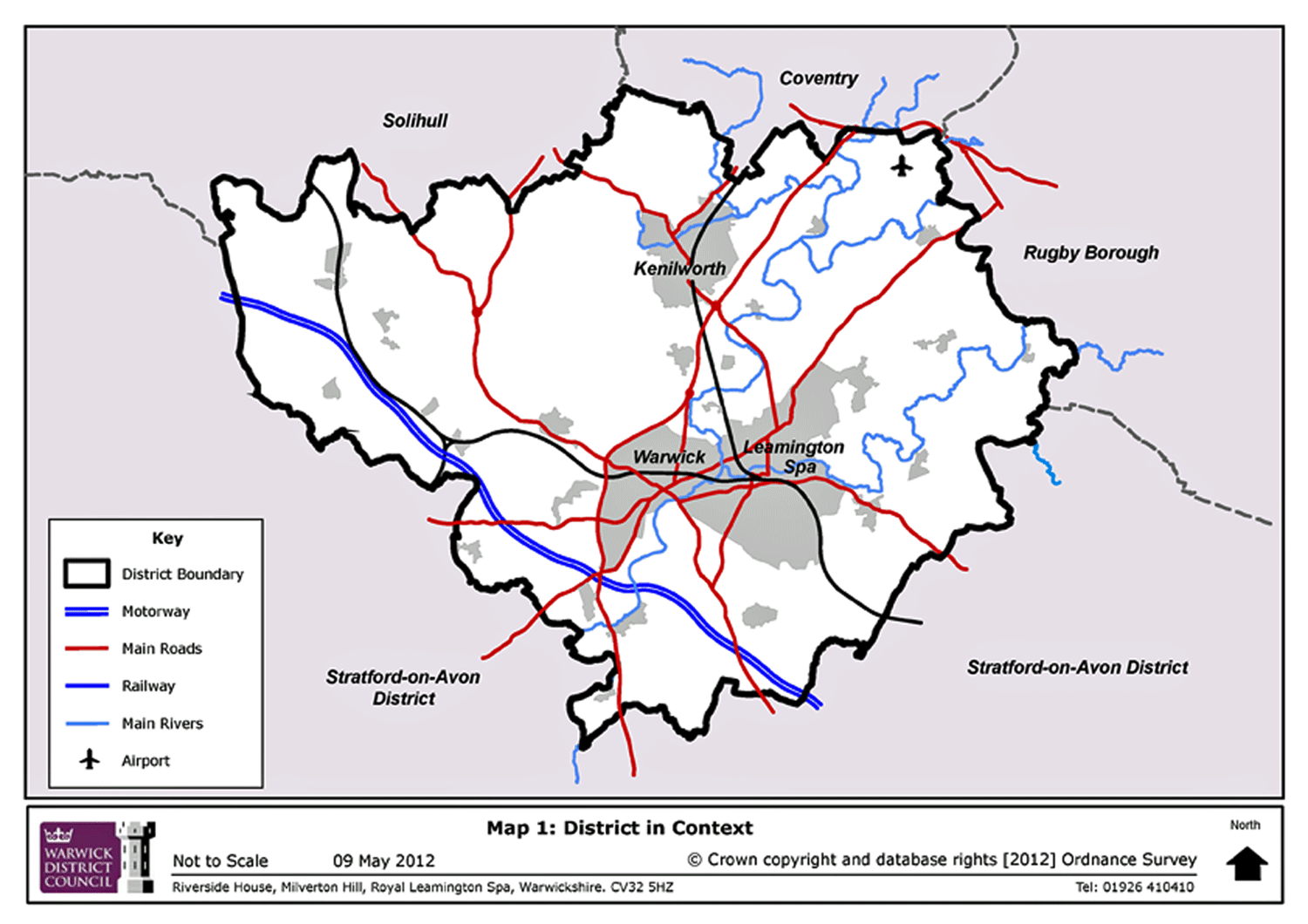
Map 1: District in Context
Map 2: Potentially Suitable Urban/Edge of Urban Sites
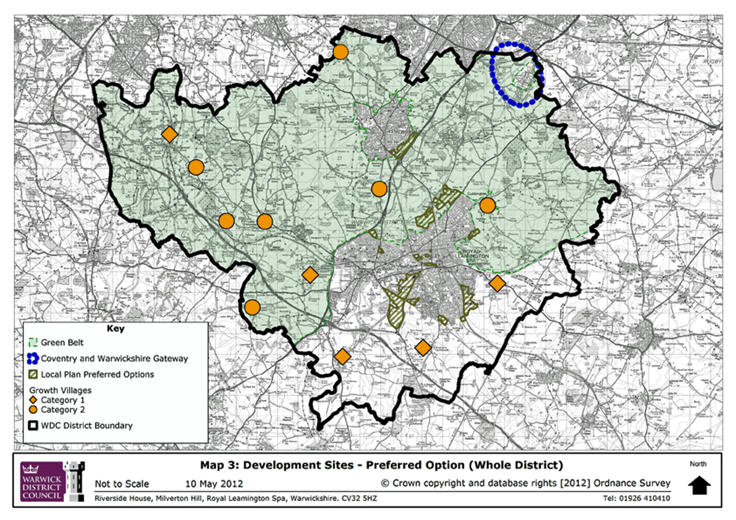
Map 3: Preferred Options (Whole District)
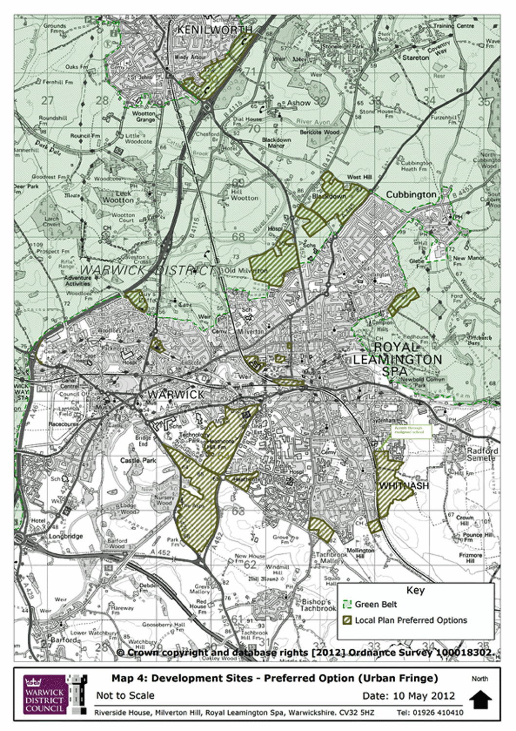
Map 4: Development Sites - Preferred Options (Urban Fringe)
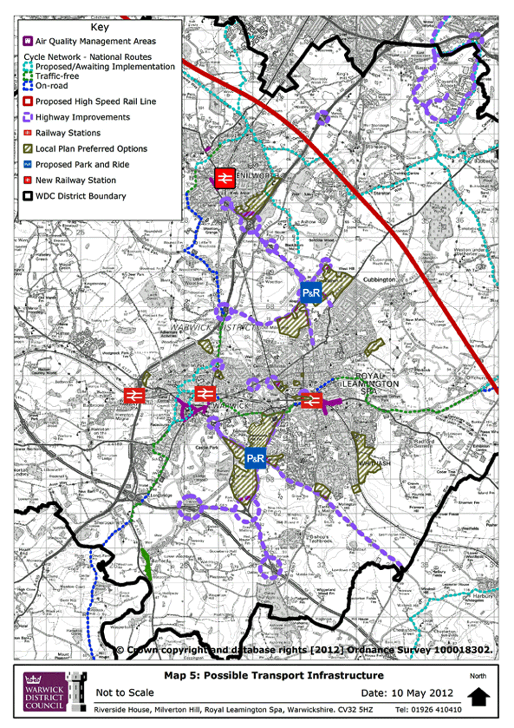
Map 5: Possible Transport Infrastructure
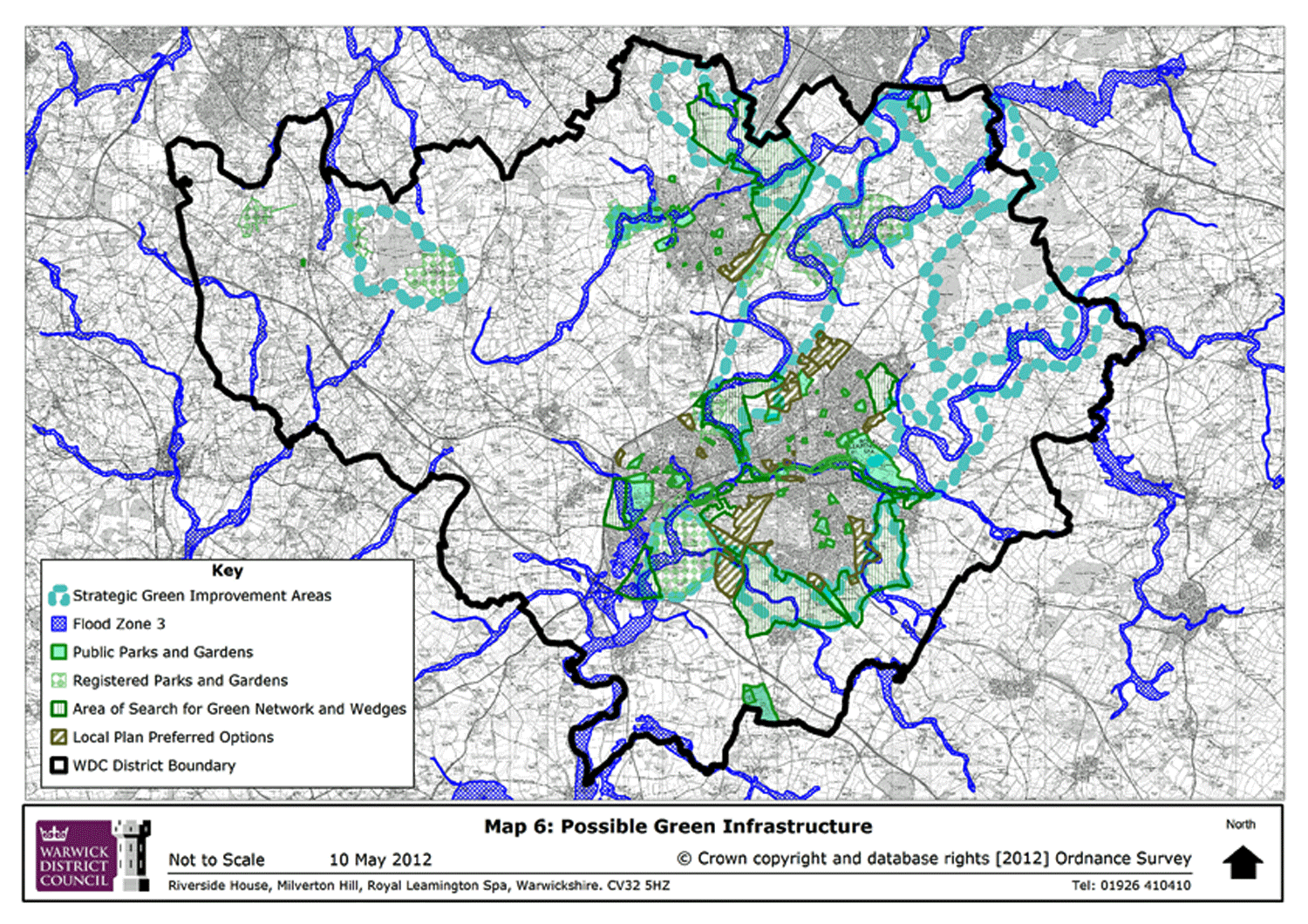
Map 6: Possible Green Infrastructure
<< Previous Page
Appendices
(1)
Map 1: District in Context
(4)
Map 2: Potentially Suitable Urban/Edge of Urban Sites
(3)
Map 3: Preferred Options (Whole District)
(5)
Map 4: Development Sites – Preferred Options (Urban Fringe)
(6)
Map 5: Possible Transport Infrastructure
(2)
Map 6: Possible Green Infrastructure
<< Previous Page
For instructions on how to use the system and make comments, please see our
help guide
.
back to top
back to top