Cubbington Neighbourhood Development Plan - Regulation 16 Submission
5.0 Neighbourhood Plan Policies View responses
5.1 This section of the CNDP sets out the planning policies (text in blue boxes) to manage development in Cubbington up to 2029. The policies are defined below each CNDP draft objective. Whilst the policies are divided between the objectives the policies of the plan should and will be read as a whole.
CNDP OBJECTIVE 1 - To protect and enhance green spaces.
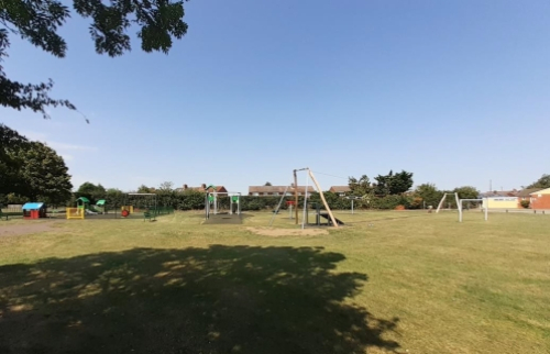
Figure 13 Cubbington Playing Fields
Introduction
5.2 It is clear from the questionnaire survey that residents want to see Cubbington's green spaces protected – 99% of respondents agreeing with this. Residents do not wish to see development take place that would have the effect of "joining" the village to neighbouring settlements and wish for the areas currently used for walking and enjoying the countryside to be protected. The CNDP will seek to do so by designating Local Green Spaces, a national planning policy protection, that protects, once designated, such spaces in the same way as Green Belt; and by identifying other green spaces to be protected with a less restrictive CNDP protection. The CNDP also seeks to encourage enhancements to these green spaces when suitable opportunities and funding arise.
5.3 In terms of the areas of Green Belt that separate Cubbington from other areas and protect the local countryside this is a strategic planning matter and will be dealt with through the SWLP. But the Parish Council will engage fully in the preparation of the SWLP and use evidence and views collected in the CNDP's own preparation process to seek to ensure that Green belt boundaries remain unchanged. An objective supported during informal consultation on the CNDP.
Policy CNDP1 – Protecting Local Green Space
The areas listed below and shown on the Policies Map are designated Local Green Spaces in accordance with paragraphs 101 and 102 of the NPPF:
CNDP1/1 - Cubbington Playing Fields
CNDP1/2 - Austen Court play area
CNDP1/3 - North Cubbington Wood
CNDP1/4 - South Cubbington Wood
CNDp1/5 - The Runghills
Development, including enhancements, of the designated Local Green Spaces will only be permitted when consistent with national planning policy for Green Belt.
Figure 14 Austen Court Park and Village Hall Park
Background/Justification
5.4 Paragraph 105 of the National Planning Policy Framework (NPPF) allows local communities, through neighbourhood plans, to protect green areas of particular importance to them by designating Local Green Space.
5.5 Paragraph 106 of the NPPF goes on to advise that
“the Local Green Space designation should only be used where the green space is:
a) in reasonably close proximity to the community it serves;
b) demonstrably special to a local community and holds a particular local significance, for example because of its beauty, historic significance, recreational value (including as a playing field), tranquillity or richness of its wildlife; and
c) local in character and is not an extensive tract of land.”
5.6 Policy HS3 of the WLP states that:
“The Council supports the principle of designating land as Local Green Space.
Local communities, through Neighbourhood Plans, may designate Local Green Spaces that are demonstrably special to their local community and of particular local significance in accordance with national planning policy.”
5.7 A small number of open spaces in the neighbourhood area have been assessed to see if they meet the designation criteria set out in national planning policy (Table 2).
Policy CNDP2 - Protecting Other Green Spaces
Development that would result in the loss of other green spaces within the neighbourhood area will be only supported when:
- Equivalent or better provision is provided elsewhere within the Cubbington neighbourhood area; or
- It can be clearly demonstrated by the applicant that the open space no longer performs a useful open space function in terms of the local environment, amenity, or active public recreation use.
Background/Justification
5.8 As well as the key green spaces that are suggested for the highest level of protection as designated local green spaces under Policy CNDP1, the neighbourhood area also has several other important green spaces that perform a variety of useful functions (Table 2). These can sometimes be smaller, often quite incidental green spaces that help to make the area a greener place and all add to the quality of life enjoyed by residents and visitors. It is proposed that these spaces are also protected, but not with the high degree of protection offered to designated local green spaces (protection that is consistent with national Green Belt planning policy) that precludes most built development. The green spaces identified in Policy CNDP2, that are not considered to meet the national planning policy tests for being designated as Local Green Spaces, could be developed in certain circumstances and these are set out in Policy CNDP2.
5.9 In addition to protecting the two spaces identified under Policy CNDP1 and other smaller spaces residents and parish council are also concerned about any future loss of Green Belt land. Not only the impact that this has on maintaining Cubbington's separation from Leamington, but also the impact of any house building on the Green Belt and what this will mean for future generations, in particular when it comes to the loss of productive farmland and the wider country's food security, and the loss of countryside with its natural biodiversity.
5.10 As a possible way to utilise the groundwork already in place at the HS2 compound on Rugby Road, we suggest a sympathetic development in a naturalistic style which might also include light refreshment facilities, potential cycle paths, improved access to existing public footpaths and green spaces. This would act as a hub for walkers wishing to take advantage of the local countryside and the adjacent footpaths. It could include electric car charging points which would also be within reasonable distance for residents in Cubbington and Weston under Wetherley.
Table 2. Local Green Space Assessment
|
Site Name |
Proximity to the community it serves |
Demonstrably special? |
Local in character? |
Any other comments? |
|
HS2 route |
Adjacent. |
Yes. |
Yes. |
Villagers use the land between Cubbington woods and the village for walking and recreation. They would wish all land between the village and the HS2 line to be maintained as open green space within the Parish boundary Including sites ref 202 as shown on the South Warwickshire Local Plan |
|
Site 97 South Warwickshire local plan |
Adjacent |
Yes |
Yes |
Residents wish the open land between Lillington and Cubbington to remain agricultural and oppose the prospect of the two being conjoined and thus lose the village character. |
|
Mill Lane (The Nob) |
Adjacent |
Blackberry picking area, used by dog walkers, families, cyclists, used by local Brownies so recreational. Also tranquil - space away from houses and rich in wildlife. |
Yes |
Blackberry picking area, used by dog walkers, families, cyclists, used by local Brownies so recreational. Also tranquil - space away from houses and rich in wildlife. |
|
Austen Court Play Area |
Central, next to a primary school. |
Well used especially after school. |
Views to South Cubbington Wood and across field. |
Used by children |
|
Cubbington Playing Fields |
Central |
Community Garden – children's gardening club, sensory garden, busy play area. |
Yes |
Recently updated and now a well-used and loved facility. |
|
North and South Cubbington Woods |
Yes. North Cubbington Woods can be accessed on foot from Cubbington using Public Right of Way (PROW) 130b and South Cubbington Woods using PROWs 129d and 130. |
Used by walkers and families as a quiet relaxing area. The Millenium Way/Shakespeare's Avon Way crosses the through the centre of South Cubbington Wood. |
Yes. Woodland sites with clear boundaries from adjoining field systems. |
Both as Ancient Woodland and Local Wildlife Sites. |
|
Runghill Wood |
Yes. Runghill Woods can be accessed on foot from Cubbington using PROW 131 and 132. |
Used by walkers and families as a quiet relaxing area. The southern and eastern boundaries of the wood are sections of the Millenium Way/Shakespeare's Avon Way. |
Yes. Small, enclosed woodland. |
PROW network provides access to Newbold Comyn Park. Local Wildlife Site. |
CNDP OBJECTIVE 2 - To ensure new development creates a high quality, beautiful and sustainable buildings and places that reinforce the identity of Cubbington and the surrounding countryside.
Introduction
5.11 National planning policy seeks to create high quality, beautiful and sustainable buildings and places. Good design is seen as a key aspect of sustainable development, because it creates better places in which to live and work and helps make development more acceptable to local communities. This section of the CNDP seeks to help to secure good design in the Cubbington neighbourhood area.
Policy CNDP3 – Sustainable Design and Construction
All new development should be of high quality and good design. To ensure that this is achieved new development will be assessed against criteria (a) to (w), where relevant to the development proposed.
Development should seek to exceed minimum standards for energy efficiency and resource use and seek to be carbon neutral, thereby contributing to reducing the effects of climate change. Development will not be supported where it is of poor design that has an adverse impact on the character of the area.
- It promotes or reinforces local distinctiveness of Cubbington by demonstrating that account has been taken of existing good quality examples of street layouts, blocks and plots, building forms and styles, materials, detailing and vernacular of the immediate locality within which the development is to be situated;
- It is designed in such a way so as to make a positive use of local landform, trees, hedgerows and other vegetation and for larger proposals has had suitable regard to landscape setting and settlement pattern;
- It conserves or enhances existing wildlife habitats and incorporates new native planting (if appropriate to the site and its context) and landscaping that create new habitats, nesting (e.g., for birds and bats), encourages pollinators and provides foraging opportunities. Overall, a net gain in biodiversity should be demonstrated;
- It uses space and creates new public open spaces that are enclosed, integrated and overlooked by buildings and are in prominent useable locations. Such spaces should use native planting (if appropriate to the site and is context) and planting to encourage pollinators;
- It includes sufficient amenity space to serve the needs of the development and its users;
- It includes appropriate boundary treatments that reflect local context and landscaping using predominantly native species to support a net-gain for wildlife. It provides highways for hedgehogs by allowing access through boundary walls and fences;
- It does not have a detrimental effect on the amenity of occupiers of neighbouring property;
- It does not have a severe cumulative adverse effect on the safe and efficient operation of the existing transport and road infrastructure;
- It includes measures that seek to improve pedestrian facilities and linkages in the Parish and beyond to encourage walking and cycling, wherever possible;
- It makes a contribution to local identity, and sense of place. Proposals should not feature generic designs and should set out how they take account of the locally distinctive character of the area in which they are to be located within any submitted Design and Access Statement;
- It respects the height of the buildings in the immediate surrounding area. Future housing development will generally be expected to be no more than two storeys;
- It uses, and where appropriate re-uses, local and traditional materials appropriate to the context of the site, or suitable high quality alternatives that authentically reinforce or positively contribute towards local distinctiveness;
- It contributes to reducing carbon emissions by incorporating measures to reduce energy consumption (e.g., building orientation, siting, areas for outdoor drying) and, where possible, sources of renewable energy. Where such features are included, they should be appropriate in scale to the building of good design and well sited. Such features should also be sympathetic to the surrounding area;
- It is designed to be as water efficient as possible e.g., by incorporating water collection measures;
- It uses existing watercourses and ditches, surface, sustainable drainage systems (SUDS) to hold rainwater in storms. SuDS should be planted with native vegetation to support wildlife. All paving should be semi-permeable to allow run-off to drain away;
- It includes features to minimise light pollution;
- It includes space for off road/pavement storage of refuse and recycling bins;
- It has appropriate car parking in accordance with locally adopted standards. Car parking should be sited in such a way that it is unobtrusive, does not dominate the street scene, and minimises the visual impact of car parking. Car parking surfaces should be permeable to minimise run-off;
- It links to existing rights of way and does not restrict the use and enjoyment of such routes;
- All new residential development should provide external wall-mounted charging points for plug-in and other ultra-low emission vehicles for each dwelling that is to have a private drive or garage. Where communal car parking is provided this should also contain charging points. Larger homes, such as those with 3 bedrooms or more, should consider providing facilities to charge more than one vehicle at once;
- It uses Secured by Design principles;
- It ensures there is no loss of, or damage to, existing trees or woodland. Where trees or woodland cannot be retained, they should be replaced preferably on site, where this cannot be achieved suitable offsetting measures to provide replacement should be provided off-site;
- When proposals include green infrastructure (GI) applicants will be required to produce a GI plan. This should demonstrate how the development links to the exiting GI network and how any open spaces and garden areas within the development will be permeable to wildlife; and
- Where development will have an impact on the area's drainage system applicants must be able to demonstrate that such an impact does not impact negatively on the drainage or flood risk in the area and where this cannotbedemonstratedapplicantsmustbeabletodemonstratehowany negative impacts can be addressed through increased drainage capacity or mitigation measures.
Background/Justification
5.9 Policy CNDP3 sets out a criterion based policy that will be used to encourage development that positively contributes to and enhances the character of the neighbourhood area and its settlements.
5.10 Policy CNDP3 will provide a distinct, neighbourhood area specific, set of criteria against which to assess planning proposals and which should be used by applicants and their design teams in the preparation of planning proposals. The aim of the policy is to promote design and construction that make development in the area as sustainable as possible, construction that moves towards zero carbon emission and enables people to live more sustainably and reduce modern life's impact on the environment.
5.11 By setting this local policy the CNDP is helping to meet one of the key aims of national planning policy – "achieving well designed places", NPPF paragraph 131 states:
"The creation of high quality, beautiful and sustainable buildings and places is fundamental to what the planning and development process should achieve. Good design is a key aspect of sustainable development, creates better places in which to live and work and helps make development acceptable to communities. Being clear about design expectations, and how these will be tested, is essential for achieving this. So too is effective engagement between applicants, communities, local planning authorities and other interests throughout the process."
To this effect there is a National Design Guide and National Model Design Code.
5.12 In the future, Design and Access Statements should demonstrate how applicants have had regard to the criteria listed in Policy CNDP3, for smaller proposals not all will be relevant, but applicants should still explain why they have reached this conclusion in their Design and Access Statement.
5.13 Policy CNDP3 does not seek to stifle innovation or produce pastiche copies of the past. Innovation and contemporary design are encouraged, but here, as with all new development, applicants and their architects should draw on the past to inform their proposals to ensure that new development is in keeping and harmonises with that of the past.
5.14 In seeking to achieve good design it can often be the small details that result in a development achieving or failing to achieve this objective. This can be the result of a single poor choice, for example the wrong brick colour, or use of the wrong window shape. In these days of mass production and standardised house types the temptation to produce a "could be anywhere" solution is strong. But such solutions fail to undertake a proper analysis of local context and should be avoided. Such an approach is in line with national planning policy which states that "Development that is not well designed should be refused, especially where it fails to reflect local design policies and government guidance on design [National Design Guide and Model Design Code], taking into account any local design guidance and supplementary planning documents such as design guides and codes". Policy CNDP3 provides such local design policy guidance. The Parish Council may, in time, supplement Policy CNDP3 by preparing a Design Code for the area.
5.14 Correspondence relating to development at Church Lane has set out Severn Trent's concerns about the area's existing sewer network due to extensive growth in the area and increased flood risk (Appendix 5). Severn Trent conclude that the existing network has insufficient capacity. Criterion x) of Policy CNDP3 seeks to ensure that such issues are addressed through the planning process so that there are no negative impacts on the drainage system and a resulting increase in flood risk.
5.15 The Building Regulations set standards for energy efficiency and resource use e.g., that of water. Government is committed to zero carbon homes by 2030 to reduce the impact of new build housing on the environment, especially the impact of climate change. The CNDP, through Policy CNDP3 encourages developers to go beyond the minimum standards in the Building Regulations, so that new development in the neighbourhood area makes the move to zero carbon sooner rather than later. Warwick District Council have also produced a Net Zero Carbon Development Plan Document with the same aim.
CNDP OBJECTIVE 3 - To conserve and enhance the natural environment and built heritage assets of the area.
Introduction
5.16 The neighbourhood area is also valued for the surrounding local countryside. This provides a number of benefits: it can be accessed along the network of footpaths and bridleways that provide opportunities for recreation; it provides valuable separation between Cubbington and larger urban settlements. The Green Belt is the strategic policy that helps retain these settlements' separate identities; and the countryside is valued for the visual and other qualities of the local landscape. Also significant and integral to the identity of the area are the elements of our built heritage, including the Conservation Area and listed buildings.
Policy CNDP4 - Conserving and Enhancing the Landscape
New development should conserve or enhance the area’s landscape character to enhance the sense of place and history and to provide recreational opportunities within tranquil settings by:
- Protecting the historic character and settlement pattern of the area maintaining the distinct settlement of Cubbington, individual farmsteads and conserving heritage assets;
- Retaining the network of fields and hedgerows;
- Retaining the network of water features including rivers, streams and ponds;
- Protecting woodland (including the ancient woodland of North Cubbington Wood, South Cubbington Wood and Weston Wood), veteran and mature trees and hedgerows;
- Planting new hedgerows and improving existing hedgerows through suitable planting of native plant species;
- Where necessary undertaking a Landscape Visual Impact Assessment (LVIA) to assess the impact of the development on the significant views identified on the Policies Map;
- Retaining, improving and supporting the creation of new Public Rights of Way;
- Screening urban forms of development and including design features that soften the transition from urban development into countryside; and
- Where feasible and suitable, to introduce new planting of coverts and tree belts to restore the Feldon Parklands character.
5.17 Natural England has produced profiles for England's 159 National Character Areas (NCAs). These are areas that share similar landscape characteristics, and which follow natural lines in the landscape rather than administrative boundaries, making them a good decision-making framework for the natural environment. Cubbington Parish lies within NCA NCA 96 Dunsmore and Feldon.
5.18 NCA profiles are guidance documents which can help communities to inform their decision-making about the places that they live in and care for. The information they contain will support the planning of conservation initiatives at a landscape scale, inform the delivery of Nature Improvement Areas and encourage broader partnership working through Local Nature Partnerships. The profiles will also help to inform choices about how land is managed and can change.
5.19 Dunsmore and Feldon is predominantly a rural, agricultural landscape, crossed by numerous small rivers and tributaries and varying between a more open character in the Feldon area and a wooded character in Dunsmore. The name Feldon refers to the old English term feldmeaning 'open cleared land' and expresses the contrast, in medieval times, with the more wooded Arden area to the north-west.
5.20 The area is an important food producing area and the agricultural expanse of large arable fields, improved pasture and small villages forms a transitional landscape between the surrounding National Character Areas (NCAs). The land to the north comprises the wedge-shaped area of low ridges and valleys lying between Leamington Spa, Coventry and Rugby, and is known as Dunsmore. This still retains a character of historic heathland and woodlands such as the Princethorpe Woodlands which are the most important cluster of ancient woodlands in Warwickshire and an outstanding example of a large area of semi-natural habitat. The woods sometimes create a sense of confinement in the generally open landscape. The fringes of the plateaux are all similar in character but have open views framed by low hills and settlements.
5.21 Each NCA includes Statements of Environmental Opportunity:
- SEO 1: Protect and appropriately manage the historic character, settlement pattern and features of Dunsmore and Feldon, in particular its areas of archaeological and heritage interest, including the deserted settlements and ridge-and-furrow sites, ancient woodlands, veteran trees, farmsteads, country houses and landscaped parklands, and enhance the educational, access and recreational experience for urban and rural communities.
- SEO 2: Protect and appropriately manage Draycote Reservoir and the important network of natural and manmade rivers, streams, ponds, canals and other wetland habitats for their important role in water provision and water quality, for the species they support and for their contribution to recreation, sense of place and geodiversity.
- SEO 3: Protect and manage the mosaic of habitats including woodlands, hedgerows and heathlands, particularly ancient and semi-natural woodlands, together with sustainable management of agricultural land, and new planting of woodland and heathland, where appropriate, to ensure continued provision of food, to extend the timber and biomass resource and to contribute to pollination, biodiversity and carbon storage, and for the benefits to soil and water management.
- SEO 4: Protect and manage the landscape character, high tranquillity levels and the historic settlement character to enhance sense of place and of history and to promote recreational opportunities; and ensure that new development is sensitively located and designed, integrate green infrastructure links into development, encourage new woodland planting to soften urban fringe developments and promote recreational assets such as the National Cycle Routes.
5.22 The openness of the land around the village and New Cubbington is protected through strategic Green Belt planning policy, Policy CNDP4 seeks to protect key features within the landscape. These include views, such as that of the Leam valley; fields and hedgerows e.g. those on Kenilworth Road looking north towards Coventry; public rights of way e.g. to Newbold Comyn in Leamington Spa and the route of Shakespeare's Avon Way; and North and South Cubbington Woods (Appendix 4).
5.23 The biggest threats to the landscape of the neighbourhood area are from HS2 the line of which will run to the east of Cubbington village (Figure 16) and new housing development. Figure 17 shows how the impact of HS2 could potentially be managed within what is shown in Figure 18 is a landscape that has a high sensitivity to new housing development.
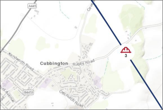
Figure 16 HS2 Route
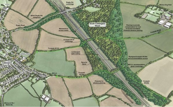
Figure 17 HS2 Potential Landscaping Treatment
5.24 Policy CNDP4 will be used in the development management process (i.e. when planning applications are being prepared and considered by decision makers) to help identify the key features of the local landscape and where these features need to be protected and enhanced.
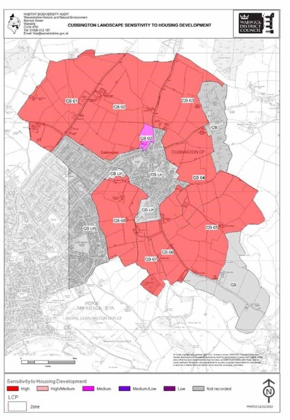
Figure 18 Landscape Sensitivity to Housing Development
Policy CNDP5 – Cubbington Conservation Area
All new development within and affecting the setting of the Cubbington Conservation Area (Figure 10) will be expected to maintain and, where possible, enhance the positive attributes of the Conservation Area and its setting. In particular development proposals should:
- Maintain the historic pattern of development by respecting the form of settlement and the historic street pattern;
- Retain and enhance any non-designated heritage assets;
- Use correct historic detailing for windows, doors and roof coverings;
- Ensure that any development on key entrances (e.g. Church Lane) are designed to a high quality;
- Retain trees, banks and open spaces;
- Retain and enhance traditional shopfronts;
- Ensure that any development on key road junctions respects the character of the area and is suitable to this sensitive setting, avoiding clutter, overengineered traffic management solutions and inappropriate signage; and that the following important views are protected:
- Views across the slope of the churchyard;
- Views across the greensward of the field and churchyard from Church Terrace;
- Views along Church Lane, particularly north to St Marys Church;
- Views from Church Terrace across the field adjacent to Manor Cottage; and
- The view up the High Street to the junction with Queen Street.
Background/Justification
5.25 Cubbington Conservation Area (Figure 10) centred around the Church of St Mary (Figure 19) and its churchyard was designated in 1969 and extended in 2001. An important entrance to the Conservation Area is Church Lane, this is bounded by a series of small cottages, which are Grade II listed, with leafy banks rising on either side of the road. There are then important views across the slope of the churchyard and the field adjacent to Manor Cottage on the opposite side of the Lane. The northern side of the field is bounded by Church Terrace, which is an interesting collection of nineteenth century cottages with only pedestrian access. There are important views across the greensward of the field and churchyard from Church Terrace. Adjacent to Church Terrace is an important open space.
5.26 At the junction with High Street and Church Lane is an important group of buildings, including the Manor House, The Old Manor House, and the Public House, this area is also characterised by the high retaining wall of the Manor House garden signifying the change in level along the length of Church Lane. This character is maintained along the south front of the churchyard.
5.27 The character of the Conservation Area changes as the High Street curves away from the Manor House. Here the character is defined by a variety of small scale late eighteenth century buildings.
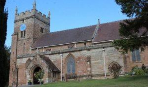
Figure 19 St Mary's Church
5.28 The character of small scale buildings is maintained via High Street and past the junction with Queen Street and also includes the nineteenth century Ledbrooke Hall, a key building in the street scene, now a house.
5.29 There are a number of traditional retail premises which open onto the square which was redeveloped in the 1970's and is not included in the Conservation Area.
5.30 Policy CNDP5 identifies these key features and will be used to help ensure, along with statutory provisions, that the character and setting of the Conservation Area are conserved.
CNDP OBJECTIVE 4 - To protect and enhance local community facility provision
Introduction
5.31 One of the key themes identified from the survey was that local residents wanted to protect and see local community facility provision improved. The CNDP will seek to do this through planning policy (Policy CNDP6). In terms of improvements many of these require the buy-in of service providers and, of course, financial resources.
Policy CNDP6 – Protection and Enhancement of Community Facilities
The community facilities listed below and identified on the Policies Map will be protected in accordance with Local Plan Policy HS8.
CNDP6/1 - Cubbington Village Hall
CNDP6/2 - St Mary’s Church
CNDP6/3 - King’s Head
CNDP6/4 - Cubbington Post Office
CNDP6/5 - The Queen’s Head
CNDP6/6 - Cubbington Sports and Social Club
CNDP6/7 - Our Lady of St Teresa’s Catholic Primary School
CNDP6/8 - Cubbington Church of England Primary School
CNDP6/9 - Rugby Tavern
CNDP6/10 - Cubbington Methodist Church
CNDP6/11 – Cliff Cleaver Pavilion
Proposals for new and improved community facilities, including a replacement Village Hall, will be supported where they are in accordance with other neighbourhood and development plan policies. New community facilities created during the plan period will also be subject to Policy CNDP6.
Background/Justification
5.32 Community facilities and services are the essential glue that help bind a community together. They not only provide important services, but area places for people to meet and interact contributing to individuals' and the community's health and well- being.
5.33 Cubbington's key local community facilities have been identified and shown on the Policies Map. These community facilities will be protected in accordance with Warwick District Local Plan – Policy HS8 Protecting Community Facilities, this states that:
"Redevelopment or change of use of community facilities that serve local needs will only be permitted where it can be demonstrated that: a) There are similar facilities accessible to the local community by means other than the car, and either; b) The facility is redundant and no other user is willing to acquire and manage it, or; c) There is an assessment demonstrating a lack of need for the facility within the local community."
5.34 Paragraph 28 of the NPPF sets out the non-strategic planning areas that can be considered in NDPs, one of these is the provision of community facilities. The questionnaire survey has revealed widespread support to seek to retain and improve the area's community facilities. This is one way that cohesion can be enhanced across the parish.
5.35 The NPPF also seeks to ensure that planning policies and decisions achieve healthy, inclusive and safe places which promote social interaction, including opportunities for meetings between people who might not otherwise come into contact with each other. Protecting the town's community facilities will be a key means of helping to achieve these national planning policy aims. NPPF also goes on to stress the need to "guard against the unnecessary loss of valued facilities and services, particularly where this would reduce the community's ability to meet its day-to-day needs."
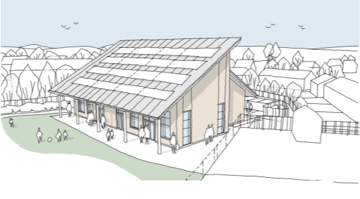
Figure 20 Architect concept drawing for a new Village Hall
5.36 Policy CNDP6 also supports improvements to community facilities where they are in line with other neighbourhood development and Local Plan policies. A particular priority is the replacement of the village hall with a building of greater community use. This would have improved insulation and renewable power sources to provide a sustainable, cost effective building and hire rate that has no draw on the parish council precept. The current hall is old, inefficient and ill fitted to present needs, originally built in the 1950s as a temporary facility. The Council would like to replace this with a new energy efficient building suitable for multiple purposes and hire which is more suitable and fit for purposes for a population of almost 4000 residents. Architects have produced sketch schemes for consideration (Figure 20).
CNDP OBJECTIVE 5 - To ensure new development is of a proportionate scale and supported by sufficient infrastructure so that it minimises impact on Cubbington's existing communities.
Introduction
5.37 The neighbourhood plan offers an opportunity for the local community to identify future infrastructure needs, particularly those arising from new development. One benefit of a neighbourhood plan is that 25%, rather than 15% of any Community Infrastructure Levy (CIL) collected in the area will be paid directly to the parish council. Warwick District Council have CIL in place.
Policy CNDP7 – Community Infrastructure
The following community infrastructure projects will be supported during the plan period.
- A new Village Hall.
- Measures to improve road safety and reduce traffic impacts through congestion and excessive speed (e.g. Windmill Hill).
- Measures to counteract noise and air pollution.
- New cycleways to link Cubbington to the Offchurch Greenway and to Royal Leamington Spa.
- Upgrades to the drainage and sewerage system.
- Community-led renewable energy projects.
Background/Justification
5.38 Community infrastructure are the physical facilities needed to support and sustain a community of people to live and work. This infrastructure can include:
- transport facilities, including public transport
- facilities to support walking and cycling
- flood defences
- educational facilities
- health facilities
- sport, recreation and leisure facilities
- open spaces
- communications infrastructure (e.g. broadband)
5.39 As well as the CNDP being an opportunity for local people to have their say on infrastructure needs, the neighbourhood plan will follow the advice in National Planning Practice Guidance (NPPG) and allows service providers than opportunity to dovetail the CNDP with their investment plans. The Parish Council's existing aspirations are set out in the Council's Business Plan (July 2023).
5.40 CIL does not replace other planning obligations such as section 106 agreements relating to individual planning applications. Warwick District enters into Section 106 obligations with developers when specific works are required to make development acceptable in planning terms, for example highway improvements or extra school provision. The Parish Council cannot set the content of Section 106 obligations, but the CNDP can be used to identify infrastructure needs before planning approval is granted on a particular site.
5.41 Residents have already expressed a wish for speed limiting measures around local schools including evaluating Average Speed sensors for the Kenilworth, Rugby and Coventry Road arterial routes, cycle ways and safer walking routes. Concern was also expressed at the number of JLR / Aston Martin employees using routes through the village for commuting.
5.42 Noise and air pollution is already recognised as an issue on the Leicester Lane, which runs through the western parish boundary. The CNDP would wish to promote further detailed surveys on main roads such as the Kenilworth and Rugby Roads in view of increased traffic volumes and HGV traffic. Concern over the noise pollution from the Thwaites factory has also been expressed by local residents.
5.43 New cycle ways from Cubbington to link with the Offchurch Greenway and improved / safer cycle provision into Leamington Spa together with measures to provide safer cycle and pedestrian routs for residents and the many school children using these roads.
5.44 Severn Trent Water have acknowledged the drainage system in Cubbington requires upgrading and the existing network has insufficient capacity (Appendix 5). Apart from sewer flooding to properties, this has the potential to pollute the natural water courses, namely the Pingle Brook, a tributary to the River Leam, harming vegetation and wildlife across a valuable green space between Cubbington and Offchurch. The basic infrastructure for handling surface water and sewage in the village has not changed since the mid-1960s when the first of the major developments was built. Since then, any new development has fed both their sewage and surface water into this pre-existing system. Post 2000 new developments have incorporated sustainable drainage systems (SuDS) that are designed to collect excessive rainfall and release it into the system at pre-development greenfield rates. However, with an increase in intensive rainfall events and a changing climate, at times overland flows have been too great for these interventions to cope. Water has been known to enter the existing sewerage system and to flood streets.