Land East of Kenilworth Development Brief
In order to fully examine constraints and opportunities of the site, consideration must first be given to the existing strategic context of the site looking at both a strategic level and settlement level and how this may influence and inform development on the site.
Strategic Level Analysis
Movement and Connectivity
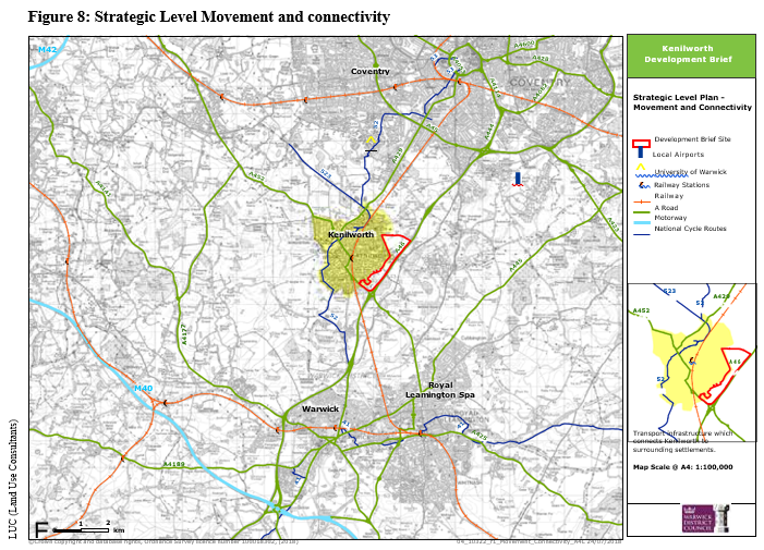
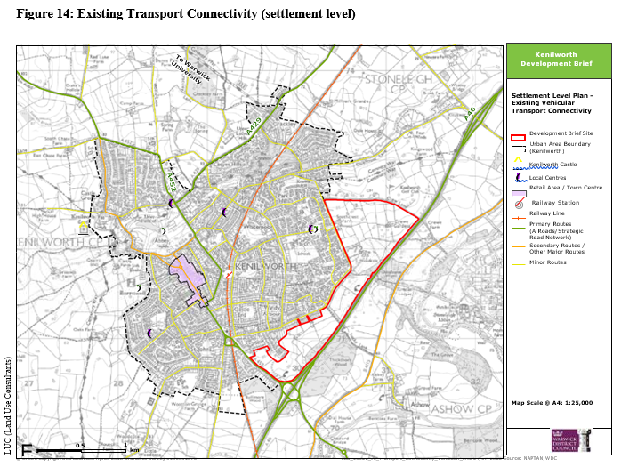
A strategic road network links Kenilworth to surrounding settlements including the city of Coventry to the north and towns Royal Leamington Spa and Warwick to the south. The A46 runs north-south immediately to the east of the site and the Thickthorn and Stoneleigh junctions provide accesses serving Kenilworth. The A46 connects to the M40 motorway via Warwick and the M69 via the A45 in Coventry.
The A452 connects Kenilworth to the M42 motorway and Solihull and the A429 provides an alternative route connecting Kenilworth and Coventry.
Two other A roads run through Kenilworth including A452 which travels centrally through the town and connects Kenilworth with Balsall Common to the north west and Royal Leamington Spa to the south east. The A429 connects northern Kenilworth to Coventry.
Newly opened Kenilworth Railway Station provides an hourly service between Coventry and Royal Leamington Spa and the station is located in a central location in the town. The station connects Kenilworth by rail to the wider railway network.
National Cycle Route 52 which connects Coventry, Warwick University and Warwick runs north - south through Kenilworth.
Agricultural Land Classification and Existing Woodland
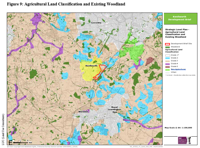
Agricultural land is classified into five categories according to its suitability to grow crops, where 1 is the most versatile and 5 is the worst. The majority of land around the edge of Kenilworth is grade 2 and 3.
There are a number of woodland areas dispersed in the locality including ancient woodland immediately adjacent to the site and extending slightly into the site.
The Development Brief site is located on agricultural land that is classified as grade 2 and 3 indicating that it is 'very good' and 'good to moderate' quality agricultural land. It should be noted that the loss of agricultural land within the site has been deemed acceptable through the Local Plan process and whilst some grade 2 quality agricultural land will be lost a significant amount of grade 2 land will remain around Kenilworth.
Landscape Character
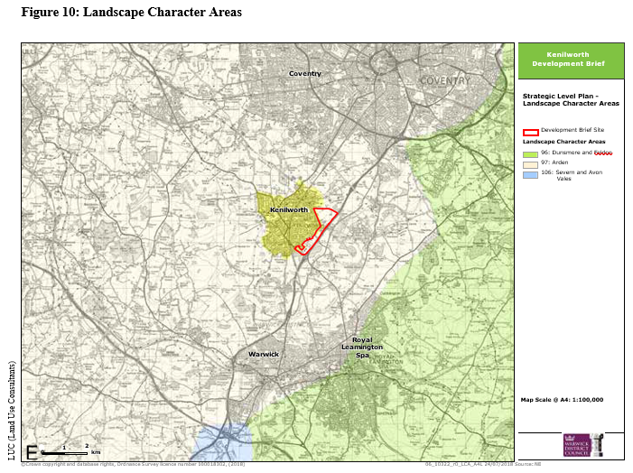
Kenilworth and the Development Brief site lie entirely within the Arden Regional Landscape Character Area. This is characterised by dispersed settlement pattern, ancient woodland and mature hedgerow oak trees. Arden is characterised by a wide range of historical and ecological features which create a landscape of intimacy and a strong sense of place.
Relevant development guidelines associated with the Arden Landscape Character Area include:
• Conserve all sites of archaeological and historical importance;
• Conserve the character of rural settlements by retaining existing features;
• Soften hard built edges through increased tree planting within and around new development;
• Protect and conserve the irregular pattern and characteristic features of roads and lanes;
• Conserve ancient woodland sites
• Conserve the built character of Arden by ensuring that new development reflects the vernacular style.
Development within the site will be expected to respect the characteristics of the Arden Landscape Character where feasible and appropriate.
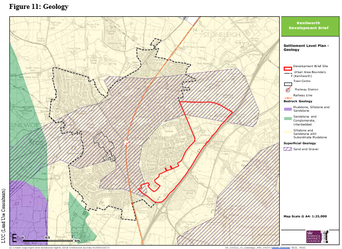
Kenilworth lies upon a bedrock of siltstone and sandstone with subordinate mudstone. A band of sand and gravel superficial geology predominantly covers the north and west of the town.
The underlying geology across the whole of Kenilworth, including that of the Development Brief site is siltstone, sandstone and mudstone. This has provided suitable ground conditions for constructing buildings and whilst local anomalies may exist it is assumed that the underlying geology is suitable for construction on the Development Brief site.
Flood Risk
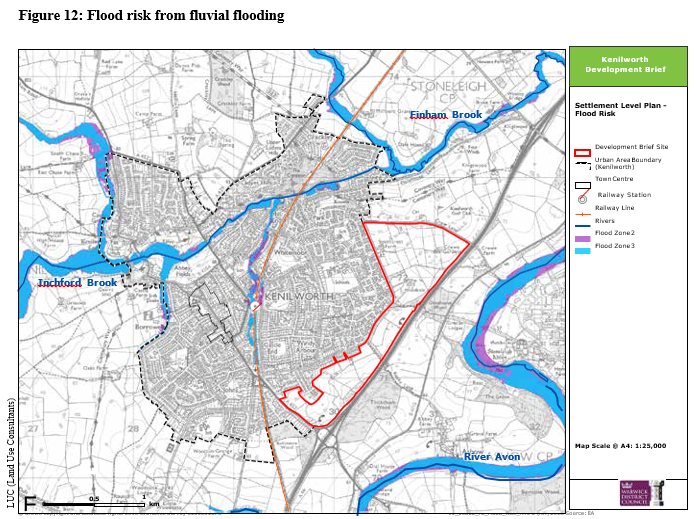
The River Avon flows to the east of Kenilworth and continues through Stratford to the south.
A meander of the River Avon along with its flood plains to the east of Kenilworth is identified as being in Flood Zone 3 as is Finham Brook to the north.
The Development Brief site lies between Finham Brook and the River Avon. The site is however in Food Zone 1 (land assessed as having a less than 1 in 1,000 annual probability of river flooding) and therefore is considered to be at low risk of fluvial flooding.
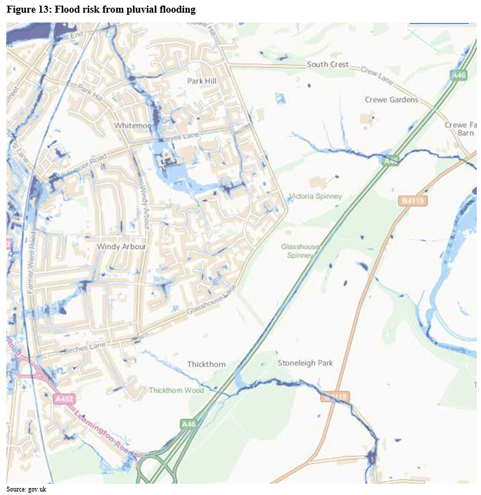
Other sources of flood risk include pluvial (surface water) and groundwater flooding. Figure 13 identifies two areas of potential surface water flood risk in areas where there are richer watercourses, one in the Crewe Gardens site towards the north east of the Development Brief site and one to the northern end of the allocated employment site. The detailed design of development on the site and specifically in these areas will need to address this known flood risk.
Transport Connectivity
Kenilworth is served by a Railway Station connecting the town to neighbouring Coventry and Royal Leamington Spa and the wider railway network from those locations.
A network of roads serve the town with the A452 Priority Road being the main road running through the town. The A46 Kenilworth by-pass provides some relief to ease traffic congestion in the town.
The only other A road entering the town is the A429 linking Kenilworth with Coventry to the north.
Kenilworth has a higher than average rate of car ownership and only 4% use public transport to travel to work, compared with the national average of 15%. As a result of high car ownership in Kenilworth extra pressure is placed on the existing transport
infrastructure. This pressure will increase as a result of additional housing and employment land in Kenilworth. It will therefore be necessary to encourage other means of transport such as cycling and walking to limit the strain put on the existing infrastructure.
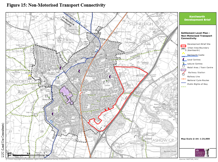
The street pattern in Kenilworth lends itself to good north-south connectivity. However, the street pattern on more recent development to the east of the town, a lack of good wayfinding and the railway line all act as barriers to east/west movement for pedestrians, cyclists and vehicles. The railway line runs through the middle of Kenilworth and severs east Kenilworth from west Kenilworth and the town centre.
It will therefore be necessary to re-establish severed east/west links where possible and improve east-west connectivity in the town.
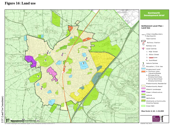
As a town with a population of around 25,000 residents, the most prevalent land use is residential.
The economy of Kenilworth comprises predominantly of retail and catering industries. Owing to Kenilworth's historic attractions, tourism is an extremely important aspect of Kenilworth's local economy providing employment and sustaining local shops and restaurants.
There are two significant employment areas within the town at the industrial estates of Princes Drive and Farmer Ward Road. Employment land is also located at Common Lane but the Local Plan accepts the loss of this poorer quality employment site and supports redevelopment for housing. Kenilworth Town Centre is the primary retail area in the town and this is concentrated on Warwick Road. There are several local shopping facilities located in other parts of the town with Leyes Lane local centre building the closest to the Development Brief Site.
Significant woodland areas are located around the outskirts of the town and a large golf course is situated north of Crewe Lane in the north east of Kenilworth. Smaller sports facilities and playing areas are dotted throughout the urban area whilst larger facilities can be found to the edge of the town.
Abbey Fields public park is located to the immediate north of the Town Centre and is a protected Scheduled Monument.
There are four allotment sites within the town (Odibourne Allotments, Spring Lane Allotments, Beehive Hill Allotments and Gypsy Lane Allotments).
Agriculture and outdoor sports uses currently occupy the site. The Local Plan allocations accept the loss of the agricultural land and sites have been identified elsewhere in the town for the relocation of outdoor sports facilities. New development on the site will need to take into consideration surrounding land uses and physically and visually connect with the existing town in order to integrate the development with the existing town.
Heritage
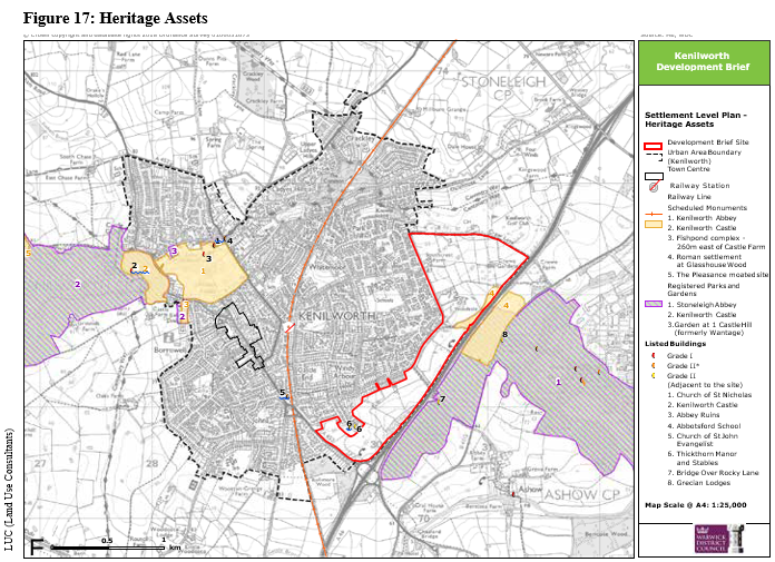
There are currently 141 Grade Listed historic assets within Kenilworth. A high concentration of these can be found in the north west of the town, in close proximity to Abbey Fields.
Grade I listed buildings including Kenilworth Castle, Abbey Ruins and the Church of St.Nicholas (High Street). Grade II* listed buildings include Abbotsford School (New Street) and the Church of St.John Evangelist (Warwick Road).
There are 5 Scheduled Monuments within the Kenilworth area including Kenilworth Abbey and Kenilworth Castle. The most relevant to the site is the Scheduled Monument 'Roman Settlement at Glasshouse Wood' as this is located partly in the H40 allocation with a larger area of the Scheduled Monument being to the eastern side of the A46.
Immediately to the east of the A46 and therefore in close proximity to the site is the Stoneleigh Abbey Grade II* Registered Park and Garden.
There are 4 Grade II listed buildings located adjacent to the site – Thickthorn Manor, Stables at Thickthorn Manor, Bridge over Rocky Lane and Grecian Lodges.
Development within the site will need to take into consideration the setting and significance of these heritage assets and minimise any potential harm. Careful consideration must be given to the use of land within the Scheduled Monument and the relationship of new development to it. Furthermore, the historic use of land means that detailed archaeology assessments
will be required and excavations undertaken where appropriate and necessary.
Biodiversity
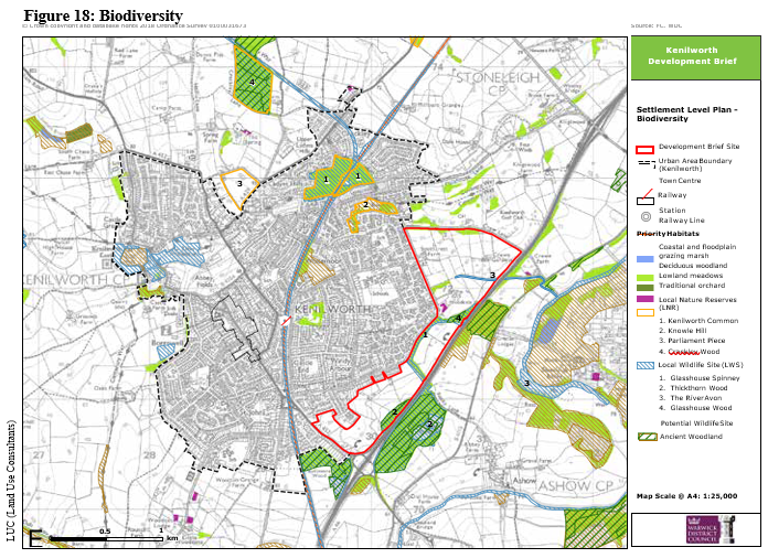
Deciduous woodland is the most common habitat within and around Kenilworth. Crackley Wood, Kenilworth Common and Knowle Hill are areas of deciduous woodland that have been recognised for their biodiversity and are designated Local Nature Reserves. The deciduous oak and birch woodland of Kenilworth Common is habitat for rare species of slow-worm
and the common Lizard as well as Kingfisher and brown trout in the Finham Brook. Lowland meadows and floodplain grazing marshland is found to the north west of the town.
Ancient woodland, deciduous woodland, a traditional orchard (within the Woodside Conference Centre and Hotel site) and Local Wildlife Sites are present within the Development Brief site. It will therefore be important that future development retains and affords protection to the Ancient Woodland and Local Wildlife Sites whilst also providing opportunities to connect new landscape
features including additional native planting with these existing features. These will act as wildlife corridors, increase biodiversity as well as creating an environment that enhances health and well-being. Other existing deciduous woodland should be retained wherever possible.
Green and Blue Infrastructure
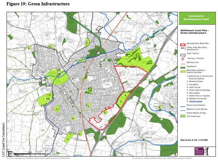
Kenilworth is surrounded by Green Belt, established in the 1950s to maintain the openness of rural areas between Coventry and Kenilworth as well as preventing coalescence with neighbouring settlements. Ancient woodland is prevalent in the area with large areas of woodland concentrated in particular to the east of Kenilworth.
Kenilworth is home to a variety of open spaces which are a valuable resource for recreation and biodiversity. To the west of the railway line, the main open spaces are Abbey Fields, Castle Park, Beehive Hill and Kenilworth Common. Key open spaces east of the railway include the eastern extent of the Common, the Kenilworth Golf Club, Knowle Hill nature reserve and Ebourne Recreational Ground.
Abbey Fields is recognised or its historic significance and is protected as a Scheduled Monument. Crackley Wood, Knowle Hill and Kenilworth Common are all protected and managed as Local Wildlife Sites.
The Greenway is a linear park route along the disused Kenilworth to Birmingham line which was closed in the 1960s. Part of the Greenway forms the National Cycle Network 52 and links Kenilworth to the University of Warwick.
Finham Brook, a lower tributary of the River Sowe flows through the northern end of the town whilst the River Avon is located east of the town.
As a result of the presence of ancient woodland within and adjacent to the site, it will be necessary for development to minimise any impact on designated areas of woodland. The site is also adjacent to Green Belt (albeit separated by the A46 and Crewe Lane) and therefore the layout and design of development should allow for a gradual transition between the town and country in order to integrate the development into the wider landscape as well as minimise any visual impact of the development.
Whilst the existing sports facilities on the site are proposed to be relocated to the south and west of the town, there is an opportunity for future development to retain some open space in these locations. It will also be important that future development and residential areas are connected to existing green infrastructure and green open space in order to promote walking and cycling as well as outdoor recreation.
Social Infrastructure
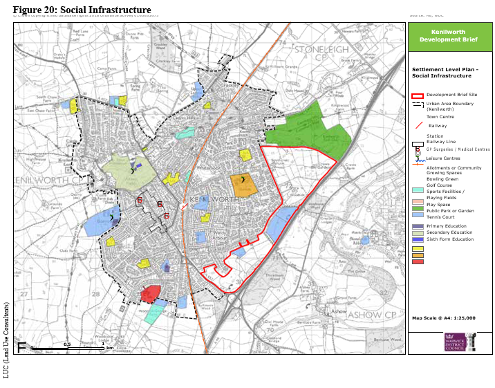
Kenilworth has a range of facilities to support the local community, including schools, leisure centres and outdoor spaces, dispersed across the town.
There are multiple primary schools in Kenilworth and one secondary school split across two sites (Kenilworth School at Leyes Lane and Kenilworth School Sixth Form at Rouncil Lane). Existing health facilities, including two GP practices and a South Warwickshire NHS Foundation Trust Clinic, are all situated within the town centre.
The sport and leisure facilities include indoor and outdoor swimming pools located at Abbey Fields and sports centres at Castle Farm and Kenilworth School. There are also a number of clubs with their own playing facilities including a rugby club, a football club, two cricket clubs, a tennis, squash and croquet club, a golf club, bowling club and several indoor gyms.
The Development Brief site currently includes land uses associated with sports and recreation which are to be relocated. It is important that the site provides social infrastructure to meet the needs of the new development including play space, accessible green space and allotments. Furthermore, the development will need to ensure that it is suitably connected to existing social infrastructure in particular including town centre retailing and primary health care facilities.
Neighbourhood Level Analysis
A study undertaken by Land Use Consultants (LUC) to support the preparation of this Development Brief includes an analysis of street typologies within the existing town identifying key characteristics and examining urban design principles including: streets and spaces; urban blocks; buildings; views; ambience and pedestrian experience. The analysis forms the foundation of the design principles for different street typologies explored later in this SPD. The detailed document from LUC is available on the Council's website.
Summary of Kenilworth Neighbourhood Analysis:
- Streets often contain a variety of architectural styles reflecting Kenilworth's rich historical past and the different stages of building development
- Red brick and render are the dominant building materials and these provide overall consistency and create a strong sense of identity
- Buildings typically front onto the street maintaining a strong relationship with the street as well as providing natural surveillance. Building set back often varies which creates interest
- Within central areas of Kenilworth the buildings often form a continuous built edge with large building blocks. Building plots vary in size reflecting different styles and ages of buildings. This creates places with character and interest
- Many streets have on-street parking although in more suburban areas on-plot parking is a dominant features of the street scene
- In more peripheral areas of the town detached and semi-detached properties tend to dominate the housing. In these areas housing density decreases dramatically
- Street trees often help create character and sense of place, helping to unify streets that contain buildings with different architectural styles
- Boundary treatments vary although sandstone walls and red brick walls are a dominant boundary treatment in more central areas whereas hedges and timber fences dominate in more peripheral parts of the town.
As well as informing the street typologies set out later in this document, development within the site should be designed in a way that pays regard to these prevailing characteristics in order to successfully integrate the development into the existing town.