Land East of Kenilworth Development Brief
CHAPTER 2 - Site Location and Characteristics
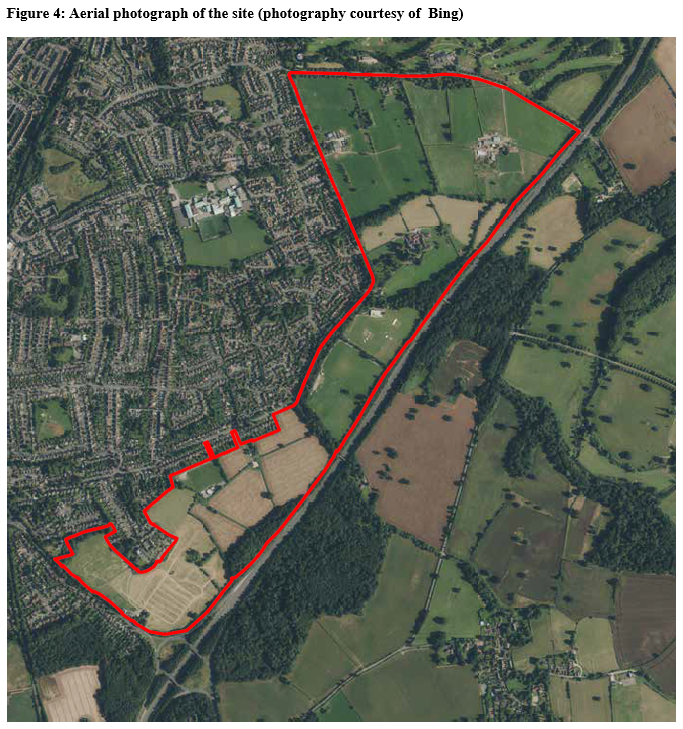
Covering an area of approximately 100 hectares the site is situated to the eastern edge of Kenilworth, Warwickshire. The site is approximately 4 miles north of Warwick, 4 miles north-west of Royal Leamington Spa and around 5 miles south-west of Coventry. Villages of Stoneleigh, Leek Wootton and Burton Green are located to the east, south and north-west respectively.
Having previously been designated as Green Belt prior to the adoption of the current Local Plan, the site is within the existing town boundary but comprises limited built development. Much of the site comprises greenfield land including grade 2 and 3 agricultural land and land used for the purpose of outdoor sports.
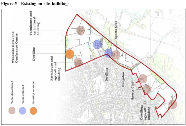
There are only a limited number of buildings across the entire site, with 9 clusters of buildings in total (See Figure 5). The buildings are either agricultural buildings, residential dwellings or sports club buildings. Woodside Hotel and Conference Centre is also located within the site. Whilst the majority of buildings on site are likely to be demolished to accommodate new development, the hotel and conference centre will be retained, albeit with a smaller curtilage.
Abutting the western edge of the site are residential roads including Glasshouse Lane and Birches Lane together with the cul-de-sacs of The Conifers, Thickthorn Close and Thickthorn Orchards to the south western end of the site. The nearby areas to the western side of these roads are largely characterised by established residential development.
To the north of the site is Crewe Lane with Kenilworth Golf Club (within the Green Belt) being located to the northern side of the road.
Beyond the southern boundary of the site is the A452 Leamington Road with residential properties forming the south-eastern edge of the town being situated on the southern side of the road. This road leads onto St.John's Gyratory and Warwick Road through the town centre.
Running parallel with the eastern boundary of the site is the A46, a 6-lane highway forming part of the strategic highway network. The A452 connects with the A46 at the Thickthorn Junction which abuts the south eastern corner of the site. To the eastern side of the A46 is land within the Stoneleigh Abbey estate.
Two public footpaths run east-west across the central part of the site. The site also includes part of a Scheduled Monument, a Local Wildlife Site (LWS) and trees subject to Tree Preservation Orders (TPO). Also present on the site are mature hedgerows delineating field boundaries, areas of mature tree belts most notably to the perimeter of the site and alongside the public footpaths and a limited number of scattered mature trees across the site.
Land generally slopes down from north to south and west to east across much of the site and two small watercourses flow west-east on the site.
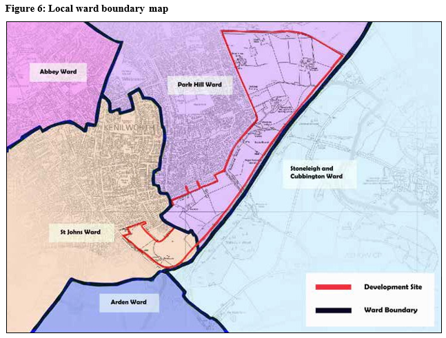
Figure 6 highlights that the majority of the site is situated within the Park Hill Ward of Kenilworth, with the southern end of the site being within Kenilworth's St.Johns Ward. The eastern boundary of the site also abuts the parish boundaries of Ashow and Stoneleigh, whilst Leek Wootton and Guys Cliffe parish abuts the southern tip of the site.
Land Ownership
At the time of writing all of the land covered by this Brief is in private ownership and includes multiple landowners. The majority of land is owned by individuals/families with freehold interests, often associated with agricultural land holdings. There are two long-term leasehold interests relating to Kenilworth Wardens and Kenilworth Rugby Club who are looking to relocate to allocated sites for outdoor sport to the west (land at Castle Farm, SP1) and the south (land
at Warwick Road, SP2) of Kenilworth respectively. Figure 7 shows the various parcels of land highlighting multiple land interests. Promotion Agreements are also in place on some of the sites.
Planning History
The site is predominantly greenfield land with longstanding agricultural and sports pitch uses.
The site has a limited planning history and there have been no applications for major development and few applications in recent years that are of particular relevance to the preparation of this Development Brief.
Perhaps the most relevant application is application reference W/17/2360 which was granted planning permission in February 2018 for the 'Erection of 33/11kV primary substation and ancillary development (renewal of planning permission W/14/1696) on land to the north eastern corner
of the Development Brief site. The primary substation has not been constructed but the land remains in the ownership of Western Power Distribution and has an extant planning consent.