Canalside Development Plan Document
Appendices
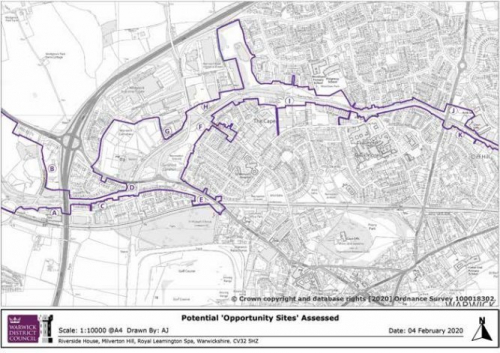
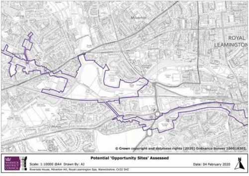
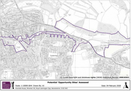
(1) APPENDIX 1 Table of Opportunity Sites Analysis
|
NO. OF SITE |
ADDRESS |
DESCRIPTION |
CURRENT USE/PLANNING HISTORY |
POTENTIAL |
|
A |
North of Warwick Parkway Station |
Gog Brook passes east to west through the site. Located between Warwick Parkway station and the canal car park at Hatton Bottom Lock. Land is wholly within the area granted pp in 1997 for the construction of the station and all associated parking and facilities. Residential pp refused in 1980 on 2.8ac. |
Station car park/land owned by WCC |
Would be difficult to reconcile any development here as it is still within the green belt. The works associated with the transport interchange were considered 'appropriate development'. |
|
B |
WCC site adjacent A46 |
Part of a complex of buildings and storage spaces owned and used by WCC. Some are used as offices, others are used to store highways equipment and as salt stores etc. Previously developed land in the green belt. |
Highway depot and head office Fire Safety HQ Trading Standards HQ |
Unavailable unless WCC wishes to vacate and sell. May have some long term potential as Green Belt 'infilling' or 'partial or complete redevelopment of a brownfield site' (para 89 NPPF). However highway sensitivities may preclude this. |
|
C |
Units off Bud- brooke Road |
Charles Court – offices for sale; Old Budbrooke Road – pair of adjoining industrial units for sale |
Industrial units |
Units appear viable and in good order. There are actually some recent builds here and the whole site has been given an update recently. No immediate potential. Well placed for the road network for businesses. Proposed junction improvements at Stanks roundabout and toward Warwick should assist access in future |
|
D |
Opposite Spring Cottage, Birmingham Road and Spring Cottage, Birmingham Road |
Previous scrapyard (land contamination issues) and unused space with a couple of derelict cottages |
Currently for sale with outline pp (2015) for up to 5 dwellings at an asking price of 650k |
None beyond what is already proposed/has permission to develop |
|
E |
Saltisford Common Bridge |
Saltisford Trust run businesses and events from adjacent land |
Previous planning application for use of canal arm for boat sales, chandlery, private and public moorings and facilities for canal traffic was refused in 1978 2001 reserved matters application for residential development refused. This part of the larger residential pp was deleted before reserved matters approved |
Valuable community/ recreational resource – unlikely to become available |
|
NO. OF SITE |
ADDRESS |
DESCRIPTION |
CURRENT USE/PLANNING HISTORY |
POTENTIAL |
|
F |
North end of Saltisford Common |
Allotments (0.344ha) |
Open land |
Unless these are underused or abandoned (which they currently are not), they are unlikely to be supported for development. There is a shortage of allotment space in the district overall. It would be difficult to make a case for developing on them. |
|
G |
Unit off Harris Road (Wedgnock Industrial Estate) |
Unit 1 recently let |
Large industrial unit of 29020 sq ft (2696 sq m) with offices |
Condition is good and has been refurbished. No reason to believe it is likely to be suitable for other development in the short term at least. Local Plan Policy EC3 protects employment land and buildings |
|
H |
Wedgnock Park Bridge |
Small area of land cut off from road access |
None |
Landlocked / inaccessible |
|
I |
Land rear of units on Ladbrooke Park (Millers Road) |
Typical industrial estate layout close to main road network |
Open land |
A mixture of units in term of age and size, but nonetheless popular and occupied. These units are meeting a need for a variety of employment units |
|
J |
Coventry Road Bridge |
Part of larger site allocated for residential in the Local Plan |
Planning application (W/19/0170) received for Montague Road allocated site for the demolition of existing buildings and construction of 148 dwellings with associated open space, landscaping, internal roads, foot ways, cycle ways and retained access for ambulance station |
Housing allocation in the Local Plan H11 Montague Road for 140 dwellings |
|
K |
Unit on Nelson Lane with landing stages to rear |
Immediately adjacent to the canal with nearby landing stages ideally located for moorings associated with the existing business. |
Industrial unit Adjacent vacant site is subject of planning application W/19/0067 for the redevelopment of the former Tamlea Building for residential purposes, (including the demolition of all existing buildings) and creation of associated access, parking, landscaping and associated infrastructure, to provide 31 residential units |
This area is occupied by Kate Boats and the wider area by other small business uses. There doesn't appear to be any current potential. The current planning application for residential use could put pressure on any future vacant sites for residential use however |
|
NO. OF SITE |
ADDRESS |
DESCRIPTION |
CURRENT USE/PLANNING HISTORY |
POTENTIAL |
|
L |
Warehouse, Nelson Lane |
Older building but occupied long term and no indication that the site may become vacant in the short term |
Industrial unit fully occupied |
Protected by Local Plan policy EC3 |
|
M |
Adjacent Charles Street Bridge/ Wharf Street |
An older set of buildings in the occupation of one company which has been there for a long time. While not attractive, it is fulfilling a purpose |
Industrial units fully occupied |
If the site were to become vacant, it could be considered for residential use, but is currently protected by Local Plan policy EC3 |
|
N |
East of All Saints Road bridge, Emscote Road |
Small site next to the road bridge over the canal near to Tesco supermarket |
Car rental / sales – may become available in the long term but access would be an issue – would have to be onto All Saints Road |
|
|
O |
Lidl, Myton Road |
Small retail unit with parking and access onto Myton Road |
Supermarket, previously garden centre/nursery |
Lidl is hoping to develop a new retail unit on Emscote Road without plans to close this unit. If this site were to become available however, it could be suitable for residential use or even a PBSA development |
|
P |
North west of Europa Way roundabout |
A tiny piece of land left over from development of the roundabout on Europa Way |
Open land/scrub |
Too small to be of any use and in noisy location for non- commercial uses with access issues onto the existing roundabout. Not suitable for development |
|
Q |
Shrublands Recreation Ground north of Queensway |
WDC recreation ground |
Recreation ground |
Protected by LP policy HS2 |
|
R |
Land between canal and properties fronting Bury Road |
Appears to be just wider areas of open land adj. to canal and towpath |
Open land |
No development potential, in fact these are the sorts of areas we should be trying to protect as wildlife corridors and more natural landscape areas. Landlocked and a narrow steep embankment |
|
NO. OF SITE |
ADDRESS |
DESCRIPTION |
CURRENT USE/PLANNING HISTORY |
POTENTIAL |
|
S |
Rangemaster, Ranelagh Street |
Existing industrial unit which has been, from time to time, rumoured to be moving location, but has never put forward any serious proposals. The unit has a façade to the canal and is surrounded on all three remaining sides by residential properties. The building presents an unwelcoming expanse of wall to the canal and is the target of much graffiti. Frequently commented upon negatively by visitors using the canal and local residents alike. |
Industrial unit |
As it seems unlikely that the current user will relocate, at least in the foreseeable future, the building and in particular the canal frontage, needs to be subject of some intensive improvements to enhance the environment along this stretch of the canal. Potential for residential as already surrounded by houses, but in the long term. Local Plan policy EC3 currently applies. |
|
T |
Althorpe Industrial Estate |
Application (W/18/1476) withdrawn for part of the site for PBSA with some employment uses at ground level in some of the blocks but another submitted for similar mixed use scheme (application W/19/0505) yet to be determined. Althorpe St is part of the Creative Quarter and mixed use development promoted by that designation |
Industrial units |
There is potential here as demonstrated by designation as part of the creative quarter and as outlined in the LP for mixed use development, however this needs to take account of existing employment uses, proximity to existing PBSA and the canal |
|
U |
1-13 Neilston Street |
Eight units for sale/let. Known as Victoria Business Centre |
Industrial/warehouse units |
Small industrial units (around 700sq ft) used mostly for automotive services etc. set into railway arches. Look well used and popular, although seem to have a high turnover given current marketing levels. Any redevelopment would be exceedingly limited and would require imagination and investment. A shortage of these types of unit generally means that they are unlikely to become available |
|
V |
Berrington Road, Sydenham |
Part of Sydenham Industrial Estate 10 Berrington Road is for sale/let (unit of 5,510 sq ft (512.08 sq m); Unit B for sale/let (unit of 19,281 sq ft industrial / warehouse unit including 5451 sq ft of office space) |
Industrial units |
Commercial property here is being sold/let and with a smaller supply now that part of the land has been redeveloped for housing, it is likely that this will continue to be the case |
|
NO. OF SITE |
ADDRESS |
DESCRIPTION |
CURRENT USE/PLANNING HISTORY |
POTENTIAL |
|
W |
Playground, Rushmore Street |
Playground with equipment for young and older children. Rated quite highly in the Value Assessment carried out on behalf of WDC by Playdell Smithyman in 2008 for the Warwick Parks & Open Spaces Audit, with a 40.35% quality rating |
Playground |
None unless playground becomes non-viable in the future. Currently a valuable local resource protected by LP policy HS2 |
|
X |
Units between St Mary's Road and Clapham Street |
Industrial estate fronting the road in mixed use area |
Industrial units |
Part of Sydenham Industrial Est – potential under DS8 but with the remaining units being currently occupied and popular, it seems unlikely in the short term |
|
Y |
Employment uses, north of St Mary's Road, west of Ramsey Road |
Continuation of Sydenham Industrial estate |
Industrial units |
Part of Sydenham Industrial Est – potential under Local Plan policy DS8 as above |
|
Z |
Land at the end of Gulliman's Way |
Open land but on flood zone 3 and 3a, as are a few of the houses! Tributary of R Leam runs between houses and this land with a weir toward the southern end |
Open land |
In flood zone 3 and 3a which makes the land unsuitable for development |