Preferred Options
PART 2: Delivering Growth
(8)7. Housing
(1)Introduction
7.1 Housing is a basic human requirement and its quality, affordability and availability are crucial for a good quality of life. Maintaining a supply of decent homes in good quality environments that can meet the needs of all is fundamental to maintaining strong communities with a healthy and mixed population, as well as a strong and growing economy.
7.2 The population of the District was estimated to be 138,670 in 2011 and this is expected to grow to about 157,000 by 2031 if recent trends in net migration continue. To meet the housing needs of this growing, and ageing, population the Local Plan must identify sites for a range of housing in suitable locations which can offer the necessary community facilities along with good access to jobs, key services and infrastructure. The homes must also be of the right types, sizes and tenures and in safe, attractive and sustainable environments where people want to live.
7.3 Warwick District is a popular place in which to live and as a result house prices in the District have been amongst the highest in the West Midlands. It is very difficult therefore for those on low incomes to find housing that they can afford in the District even allowing for the recent fall in house prices. The Local Plan must therefore include measures to help ensure that the needs of those in the community who cannot afford open market housing are also met.
(5)Relevant Issue & Strategic Objectives
7.4 Issues: The most important housing issues for the Local Plan to address are:
-
The need to provide more housing to ensure that the needs of current and future residents are addressed, particularly those of older people, and
-
Relatively high house prices limiting local people’s ability to buy or rent property in the area, creating the need for more affordable homes for families in towns and villages.
7.5 The main role of the Local Plan is to guide future development to deal with the important issues by:
-
Establishing the right level of growth in the District;
-
Finding the best location for new development and working out how that development should be designed;
-
Working out how we will use the new development and the money generated from it to improve infrastructure and services, such as schools and roads; and
-
Setting a framework for neighbourhood planning in the future.
7.6 In addressing the important housing issues, the Local Plan will aim to:
-
provide for a sustainable level of housing growth in order to meet future housing needs, reduce the number of people who currently need alternative housing, and to help deal with issues of affordable housing need;
-
provide well-designed new developments in the most suitable location; and
-
enable the District’s infrastructure to improve and support growth
7.7 The preferred level of housing growth, to address the evidenced housing need, is for an additional 10, 800 new homes to be built between 2011 and 2029, an average of 600 homes per annum. See Chapter 6.
(324)PO3: Broad Location of Growth
It is the Council’s Preferred Option to:
-
concentrate growth within, and on the edge of, the existing urban areas
-
avoid development in locations which could potentially lead to the coalescence of settlements
-
distribute growth across the District, including within and/or on the edge of some villages
-
allow for a hierarchy of growth in the rural area to include:
-
a higher level of growth in those villages with a broad range of services and public transport to the towns, and
-
a lower level of growth in some smaller villages in order to meet local need and help support existing services
-
(16)Justification for Preferred Option for the Broad Location of Growth
7.8 In developing the Preferred Option the following sources of information have been considered:
- National Planning Policy Framework (NPPF) (March 2012)
- Local Plan Report of Public Consultation (December 2011)
- Warwick District Strategic Housing Market Assessment (SHMA)(March 2012)
- Strategic Housing Land Availability Assessment (SHLAA)(May 2012)
- Joint Green Belt Study (January 2009)
- A Strategy for the Future and Sustainable Prosperity of Warwick District (December 2011)
7.9 The new National Planning Policy Framework (NPPF) includes a presumption in favour of sustainable development. It states that planning should actively manage patterns of growth to make the fullest possible use of public transport, walking and cycling, and focus significant development in locations which are, or can be made to be sustainable. On this basis, within Warwick District, the most sustainable locations are within and on the edge of the towns of Warwick, Leamington, Whitnash and Kenilworth.
7.10 The Council’s survey of land available for housing (the SHLAA) demonstrates that there is limited availability of urban brownfield land in the District – a capacity of approximately 1,320 dwellings or 11% of the total SHLAA capacity. In order to meet the housing requirement, therefore, it will be necessary to locate development on greenfield land outside the existing built up areas.
7.11 NPPF also suggests that new homes can sometimes be best achieved through planning for larger scale development, such as new settlements or extensions to existing villages and towns that follow the principles of Garden Cities. In the case of Warwick District, as there is limited availability of urban brownfield land, extensions to the urban area can offer the most sustainable location for growth.
7.12 In relation to development in rural areas, NPPF suggests that sustainable development can be achieved where it will enhance or maintain the vitality of rural communities or, in the case of a group of villages, where development in one village may support services in a village nearby. The Strategic Housing Market Assessment identifies strong demand for housing in the rural areas.
7.13 The Council’s agreed Strategy for the Future and Sustainable Prosperity of Warwick District states that the Local Plan should distribute development across the District, linked to the availability of existing, and the provision of new, infrastructure with priority given to bringing forward brownfield land wherever possible and ensuring that such development does not encourage or lead to the coalescence of settlements.
7.14 The “Helping Shape the District” consultation exercise carried out last year highlighted much concern about the levels of development which might be required to meet the District’s housing needs and the impact this would have on the character and setting of the towns. Many felt that increasing sprawl around the existing towns would damage the rural setting of the towns to the detriment of both their economies and their environment. The Council will require new development to follow the emerging garden suburbs principles in order to overcome this loss of rural character.
7.15 The Joint Green Belt Study carried out an assessment of the Green Belt around the towns and on the edge of Coventry. The findings showed that were variations in the quality of land in the Green Belt and therefore some areas around the towns may be considered for development and therefore, removed from the Green Belt.
(2)Other Options
7.16 The Council considered three other options for the broad location of growth:
- Focus development outside the Green Belt
- Disperse development in small/medium sites, including around villages
- New settlement outside the Green Belt
7.17 Under half (43%) of sites identified in the SHLAA are located outside the Green Belt. These include sites within the existing urban areas and sites to the south of Warwick, Leamington and Whitnash. This option would lead to the concentration of development within one part of the District and offer no scope for meeting the needs of Kenilworth or villages within the Green Belt. Similar issues would apply to the new settlement option.
7.18 The option to disperse development around the District on small/medium sites would meet some of the concerns expressed during the consultation exercise about the impact of large development sites. However, such a pattern of growth would make it difficult to properly plan for, and deliver, the necessary infrastructure and would be impractical in terms of the number of sites which would have to be identified. Further, this pattern of development would make it difficult to make the fullest possible use of public transport, walking and cycling and make provision for a full range of community facilities with easy access to jobs, schools and other services.
7.19 The sustainability appraisal of the options showed that the option for focusing development outside the Green Belt had clear advantages associated with the provision of sustainable transport options and reducing the need to travel. However, there would be significant impacts on the natural and historic environment due to such a high concentration of new development to the south of the towns with increased cross-town traffic. In the case of the new settlement option, there were many advantages in terms of the ability to properly plan for, and meet the needs of the whole new community but the development would need to rely upon the provision of new public transport services to the towns with limited opportunities for improving and maintaining existing services.
(43)The Location of New Housing
7.20 The Local Plan will make provision for 10,800 new dwellings between 2011 and 2029 in three phases as follows:
Phase 1: 2011-2019
Phase 2: 2019-2024
Phase 3: 2024-2029
Some of these dwellings can already be accounted for. At 1st April 2011, there were already a number of “committed” sites which had planning approval for housing. In addition, we know that over the period of the plan a number of small “windfall sites” will be developed for housing. These include conversions of existing dwellings, changes of use of buildings to dwellings and redevelopment sites. Some of these sites have been identified in the SHLAA, but many will come forward later in the plan period. If these commitments and windfalls are extracted from the total, the balance will need to be allocated in the Plan.
(14)TABLE 7.1 Housing to be Allocated in the Plan
| Dwellings | |
|---|---|
| Housing Requirement | 10,800 |
| Less: | |
| Committed Housing Sites | 1,224 |
| Small urban SHLAA Sites | 290 |
| Other Windfall Housing Sites | 2,300 |
| Total | 3,814 |
| Balance to be Allocated in Plan | 6,986 |
7.21 In line with the principles of the preferred approach to the location of growth, the Council has identified a number of sites in locations within and around the four towns and has identified 2 categories of villages which are capable of accommodating a limited amount of new development over the plan period. The sites are dispersed as follows:
(21)TABLE 7.2 Distribution of Housing
| Site Type and Location | Dwellings |
|---|---|
| Urban Brownfield Sites | 480 |
| Sites on Edge of Warwick, Leamington & Whitnash | 6,250 |
| Sites on the Edge of Kenilworth | 770 |
| Village Development | 830 |
| TOTAL | 8,360 |
7.22 The sites/ locations which have been identified would allow for the development of 8,360 new dwellings. This is over and above the balance of the requirement of 6,986 so would give an element of flexibility of about 1,370 dwellings. This flexibility allows for two potential courses of action:
- To enable some sites to be removed from the allocation proposed in the draft Plan depending on consultation and any further evidence that is provided, and/or
- To provide housing to support a Regional Investment Site in the vicinity of the A45/A46 Junction close to Coventry Airport (the Coventry and Warwickshire Gateway) if further research demonstrates that this is a suitable location (see section 8).
(79)PO4: Distribution of Sites for Housing
The following sites will be allocated for housing or mixed use development. The Council will work with developers and the local community to bring forward sustainable developments in attractive surroundings under the principles of Garden Suburbs. Larger sites will include the full range of supporting uses including open space, schools, shops, community and health facilities and, in some cases, employment
(9)Within the Urban Areas
| Site | No of Dwellings | Phase | Use (See key below) |
|---|---|---|---|
| (8)Warwickshire College, Leamington Spa | 300 | 3 | Ho/OS |
| (7)Ridgeway School, Montague Road, Warwick | 80 | 1 | Ho/OS |
| (13)Leamington Fire Station, Leamington Spa | 50 | 1 | Ho/OS |
| (6)Riverside House, Leamington Spa | 50 | 3 | Ho/OS |
| TOTAL | 480 |
(18)On the Edge of Warwick, Leamington Spa & Whitnash
| Site | No of Dwellings | Phase | Use (See key below) |
|---|---|---|---|
| (200)Myton Garden Suburb (North of Gallows Hill/ West of Europa Way), Warwick | 1,100 | 1 & 2 | Ho/Emp/OS/Com |
| (219)South of Gallows Hill/ West of Europa Way, Warwick | 1,600 | 2 & 3 | Ho/Emp/OS/Com |
| (576)North of Milverton, Leamington Spa | 810 | 2 & 3 | Ho/Emp/OS/Com |
| (504)Blackdown | 1,170 | 2 & 3 | Ho/Emp/OS/Com |
| (27)Whitnash East (South of Sydenham) | 650 | 2 & 3 | Ho/OS/Com |
| (96)Woodside Farm (South of Whitnash) | 250 | 1 | Ho/OS |
| (11)Red House Farm (East of Lillington) | 200 | 2 | Ho/OS |
| (15)Warwick Gates Employment Land (Junction of Harbury Lane/ Heathcote Lane) | 200 | 1 | Ho/OS |
| (214)Loes Farm (North of Woodloes) | 180 | 2 | Ho/OS |
| (22)Fieldgate Lane/ Golf Lane, Whitnash | 90 | 1 | Ho/OS |
| TOTAL | 6,250 |
(1)On the Edge of Kenilworth
| Site | No of Dwellings | Phase | Use (See key below) |
|---|---|---|---|
| (82)Thickthorn | 770 | 1 & 2 | Ho/Emp/OS/Com |
| TOTAL | 770 |
Key to uses:
Ho Housing
Emp Employment
OS Open Space
Com Community Facilities (Shops, Schools, Health & Community facilities)
Strategic sites of over 500 dwellings will be the subject of a Development Brief prepared jointly by the Council and developers and in consultation with the community.
(37)B. Category 1 and 2 Villages
The Council will work with Parish Councils to define the boundaries of village envelopes. In the case of villages within the Green Belt, land within the village envelope will be removed from the Green Belt to enable development to take place.
| (1)Category 1 Villages | Dwellings Phases 1,2 & 3 |
|---|---|
| (18)Barford | 100 |
| (13)Bishop’s Tachbrook | 100 |
| (32)Hampton Magna | 100 |
| (15)Lapworth | 100 |
| (30)Radford Semele | 100 |
| TOTAL | 500 |
| (1)Category 2 Villages | Dwellings Phases 1,2 & 3 |
|---|---|
| (6)Cubbington | 30-80 |
| (10)Hatton | 30-80 |
| (9)Leek Wootton | 30-80 |
| (186)Norton Lindsey | 30-80 |
| (3)Rowington | 30-80 |
| (7)Shrewley | 30-80 |
| (9)Burton Green | 30-80 |
| TOTAL | about 330 |
(17)C. Development on Brownfield Land
The Council’s preferred option is that proposals for housing development and conversions to dwellings will normally be permitted on previously-developed land in the following areas, subject to the proposals having no serious impact upon the amenity and environment of their surroundings:
-
The built up areas of Warwick, Leamington Spa, Whitnash and Kenilworth
-
Within the village envelopes of the category 1 and 2 villages
-
Within the built up areas of the following Category 3 villages, subject to the need to protect the character and scale of the village:
| (1)Category 3 Villages |
|---|
|
(2)Hampton on the Hill (1)Offchurch |
(21)D. Development on Greenfield Land
The Council’s preferred option is that housing development on greenfield land, other than the sites allocated in the plan, will not normally be permitted unless
-
it is for affordable housing
-
it is a home for a rural worker where there is a clear functional need for the person to be readily available on the site at all times.
-
It is the conversion of a rural building which is located within, or on the edge of a settlement with at least one community facility.
-
It is infill development within the existing built up areas of villages, to meet local housing need, and brought forward through Neighbourhood Plans or Community Right to Build Orders
Development on garden land will not normally be permitted unless the development reinforces, or harmonises with, the established character of the street and/or locality and respects surrounding buildings in terms of scale, height, form and massing.
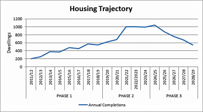
7.23 The following chart shows the potential trajectory for development in the three phases between 2011 and 2029.
(18)Justification for Preferred Option for the Location of New Housing
7.24 In developing the Preferred Option the following sources of information have been considered:
- National Planning Policy Framework (NPPF) (March 2012)
- Local Plan Report of Public Consultation (December 2011)
- Warwick District Strategic Housing Market Assessment (SHMA)(March 2012)
- Strategic Housing Land Availability Assessment (SHLAA)(May 2012)
- Joint Green Belt Study (January 2009)
- A Strategy for the Future and Sustainable Prosperity of Warwick District (December 2011)
7.25 Evidence from the Council’s assessment of potential housing land in the SHLAA shows that there is a limited supply of land within the existing built up area of the towns. The capacity for housing on suitable sites within the existing urban area amounts to about 30 dwellings in Kenilworth and about 1,280 in Leamington, Warwick and Whitnash. It will, therefore, be necessary to allocate land outside the existing built up areas on greenfield sites.
7.26 The northern, western and eastern edges of Warwick and Leamington and the whole of Kenilworth are bounded by the southernmost section of the Warwickshire Green Belt. If development is to be distributed across the District it will be necessary to alter the boundary of the Green Belt. NPPF states that, once established, Green Belt boundaries should only be altered in exceptional circumstances, through the preparation or review of the Local Plan. Further, when reviewing Green Belt boundaries local planning authorities should take account of the need to promote sustainable patterns of development.
7.27 Exceptional circumstances can include the need to accommodate housing and employment growth to meet the needs of a community where there are insufficient suitable and available sites outside of the Green Belt. Where it can be justified to review the Green Belt boundary in order to accommodate development, it is necessary to assess Green Belt land in terms of its contribution towards the five “purposes” of including land in the Green Belt (NPPF Para 80). The Joint Green Belt Study carried out such an assessment of parcels of Green Belt land on the edge of Warwick, Leamington, Kenilworth and Coventry.
7.28 In the case of meeting the housing needs of Kenilworth, there are limited sites within the built up area of the town and therefore there are no alternatives other than to review the Green Belt Boundary. The Green Belt Study identified the area between the east of the town and the A46 as suitable for further study in terms of development potential. This was largely because the A46 provided a physical barrier to the wider countryside.
7.29 In the case of meeting the housing needs of Warwick, Leamington and Whitnash, the SHLAA identifies a potential capacity within the urban area of 650 dwellings on sites of 50 or more. Outside of the built up area, and outside of the Green Belt, the SHLAA identified a capacity of 7,200 dwellings. These sites are concentrated in the area around Europa Way, Gallows Hill and Harbury Lane as well as to the south and east of Whitnash.
7.30 The Council has concerns about focussing around 6,000 new homes in such a concentrated area. The reasons for this include:
- The impact on infrastructure, in particular transport and the increased car journeys between the Europa Way area, the town centres and the M40
- The continued southerly spread of development and the impact of closing the gap between Warwick /Whitnash and Bishop’s Tachbrook
- The lack of choice of location of new housing and uncertainty about the ability of the markets to deliver this level of development in the locality within the plan period
7.31 There are advantages to locating some development to the north of Leamington Spa and Warwick. These include:
- The possibility of including some employment land within the development - employment areas are currently concentrated in the south of Leamington, leading to many cross town centre trips
- Greater choice of location of new homes
- The benefits which could be realised from the construction of a northern relief road which would relieve congestion on through routes between Warwick and Leamington town centres
7.32 Assessment of Green Belt land to the north of Warwick and Leamington in the Joint Green Belt Study concluded that the land bounded by the A46 in the west, the River Avon to the north and Sandy Lane to the east was worthy of further study. This was largely because there were no other towns to the north, from which the Green Belt would provide protection from encroachment, but also because there were other physical barriers to the wider open countryside. The Green Belt assessment suggested that the land at Blackdown was not suitable for further study. However, the land has similar characteristics to land to the west in that there are no towns to the north, from which the Green Belt would provide protection from encroachment, and there are clear boundaries to the site to protect the open countryside beyond.
7.33 The Council’s Strategy for the Future and Sustainable Prosperity of Warwick District emphasised the need for development to be dispersed across the District and also to protect the integrity of settlements by retaining the separation between them. For this reason, the Council favours the retention of an area of open countryside between the village of Old Milverton and a strategic development site.
7.34 In the rural areas, a limited amount of development is directed to those villages with a good range of services and public transport to the towns. All the category 1 villages have the benefit of a school, shop and village or community hall. Some of these villages have, in recent years, identified a local need for affordable housing but have found it difficult to bring a scheme to fruition. Other villages lack particular sizes of market homes – for example a lack of small family/ retirement homes or a lack of large family homes. A limited quota for new housing will enable villages to expand the choice of housing as well as deliver affordable homes.
7.35 The category 2 villages have fewer services but a limited amount of development may help to support existing services or even encourage new services as well as provide a greater choice of housing.
7.36 In the case of category 1 and 2 villages which are currently “washed over” within the Green Belt, it will be necessary to identify areas with potential for limited development and include it within a village envelope along with the existing built up area of the village. The boundary of the Green Belt would be adjusted accordingly around the village envelope.
7.37 Infill development and conversions have traditionally provided a very important source of supply for new housing. Over the last 10 years an average of 377 homes each year have been built through infill development including conversions and changes of use. In the urban areas, this will allow for the continued recycling of land and buildings, and the sub-division of larger homes. In the rural areas there is only expected to be a small amount of infilling as the supply of previously-developed land is limited.
(2)Other Options
7.38 The Council considered 4 options for the distribution of housing sites and these were the subject of testing by the County Council in their Traffic Flow Modelling System (S-Paramics). See Section 14 (Transport). In addition, discussions took place with the County Council on possible solutions in terms of meeting the education requirements of sites and groups of sites.
(2)TABLE 7.3 Options for the Location of Housing
| Location | Option | |||
|---|---|---|---|---|
| 1 | 2 | 3 | 4 | |
| Warwick/ Leamington/ Warwick Urban Area | 700 | 700 | 700 | 700 |
| North of Leamington/ Warwick | 2,640 | 1,470 | 2,300 | 2,640 |
| South of Leamington/ Warwick/ Whitnash | 2,765 | 4,450 | 3,900 | 3,365 |
| East of Leamington | 0 | 200 | 200 | 200 |
| East of Kenilworth | 1,620 | 1,620 | 1,260 | 770 |
| Westwood Heath (South of Coventry) | 880 | 0 | 0 | 350 |
| Rural Area | 0 | 0 | 200 | 400 |
| Total | 8,605 | 8,440 | 8,563 | 8,429 |
7.39 In terms of the transport modelling exercise, Option 4 had least impact prior to mitigation and showed the greatest improvements when mitigation was applied. However, in general the model concluded that there was little difference between the options in terms of the improvements following mitigation.
7.40 In terms of educational provision, none of the options presented difficulties which could not be overcome.
(3)Meeting the Need for Affordable Housing
7.41 The Warwick District Strategic Housing Market Assessment (SHMA) was carried out in 2011 and provided an estimate of 698 households as likely to be in need of affordable housing each year. Of this, 528 households would require a home in Warwick, Leamington Spa or Whitnash, 115 in Kenilworth and 55 in the rural areas.
7.42 The Council accepts that it would not be possible for this level of need to be met over the plan period. However, through planning policies it is possible to ensure that, when new development takes place, a proportion of the new housing will meet the needs of the District for affordable homes.
(171)PO5: Affordable Housing
(18)A. Affordable Housing on Housing Development Sites
Our Preferred Option is to require that 40% of new homes on developments of 10 or more dwellings in the urban areas, and 5 or more dwellings in the rural areas, will meet the need for affordable housing as identified in the latest Strategic Housing Market Assessment or Local Housing Needs Assessment.
The policy will apply to developments which contain self-contained units of accommodation including specialist homes for older people.
In order to take into consideration the different nature of development sites and locations within the District, as well as changing market conditions, the Council may in exceptional circumstances take a flexible approach to the policy in terms of:
-
the number of affordable units, where there is clear and detailed evidence that the site has particular constraints, the costs of which, along with the full provision of affordable housing, would result in a development which is not viable
-
the practicality of providing the homes on-site (in some cases the Council may agree to off-site provision or a financial contribution in lieu)
The policy will also set out ways in which the Council will ensure that the affordable housing :
-
meets the affordable housing needs of the District in terms of size, type and tenure
-
is genuinely affordable in relation to housing costs and local household incomes
-
is retained as affordable housing in perpetuity
-
is appropriately integrated into the whole site
-
meets certain standards of internal and external design
(7)B. Affordable Housing on Rural Exception Sites
Our preferred option is to allow the development of small schemes of affordable housing, to meet an identified local need, in village locations where housing development would not normally be permitted. This exception to housing policy will be dependent upon:
-
the scheme being located within, or adjacent to, a settlement with a reasonable level of services
-
evidence of a local need for affordable housing which cannot be met in any other way
-
the number, sizes and types of homes reflecting local need as identified in an up to date local needs assessment
-
the housing being provided in perpetuity to households with a local connection
In circumstances where there is evidence that a rural exception scheme cannot be adequately funded, the Council will give consideration to the inclusion in the scheme of some market homes to cross-subsidise the affordable homes subject to:
-
the market homes representing not more than 30% of the overall number of dwellings
-
the type and size of the market homes meeting the local need as evidenced in a local needs assessment
-
financial evidence of the need for market homes to cross subsidise the affordable homes
(5)Justification for the Preferred Option for the Provision of Affordable Housing
7.43 In developing the preferred option the following sources of information have been considered:
- National Planning Policy Framework (NPPF) (March 2012)
- Local Plan Report of Public Consultation (December 2011)
- Warwick District Strategic Housing Market Assessment (SHMA)(March 2012)
- Warwick District Affordable Housing Viability Assessment (November 2011) and Addendum (May 2012)
7.44 The consultation on the Local Plan showed that of respondents to the general questionnaire, 31% strongly agreed and 24% tended to agree that high house prices and the lack of affordable housing was an important issue. In the sample household survey, 73% of people who took part in the survey considered this to be an important issue. Nearly a quarter of residents interviewed thought that this issue should have top priority.
7.45 NPPF states that Local Plans should meet the full, objectively assessed needs for market and affordable housing. It states that where there is an identified need for affordable housing, local authorities should set policies for meeting this need on site, unless off-site provision or a financial contribution of broadly equivalent value can be robustly justified and the agreed approach contributes to the objective of creating mixed and balanced communities. Such policies should be sufficiently flexible to take account of changing market conditions over time.
7.46 The Strategic Housing Market Assessment (SHMA) identifies a high level of need arising for affordable housing of around 698 households per annum. Land Registry data shows that the average 15-percentile house price in the District for the third quarter of 2011 was £145,000. This compares with£110,000 in Warwickshire and £82,687 in the West Midlands. The ratio of the lower quartile house price to lower quartile earnings was 7.49 in 2011. This compared with 6.79 in Warwickshire and 5.46 in the West Midlands. These figures demonstrate a high affordability ratio in the District even though the towns have a high proportion of small houses and flats.
7.47 It is clear that the Local Plan will not be able to set out policies which meet the full needs for affordable housing since the annual need exceeds the annual housing requirement. The SHMA suggests that if all needs are to be met, about 77% of new homes should be affordable. However it accepts that a realistic proportion might be 30% or 180 each year.
7.48 NPPF also states that in plan making local planning authorities should give careful attention to viability and costs so that development is deliverable. The Affordable Housing Viability Assessment (AHVA) assessed a number of hypothetical sites typical of sites coming forward in the District. For each site type, a number of different affordable housing policy options were tested for viability within three different market positions (baseline, mid-market and improved market). The results of the assessments showed a wide variation of levels of viability according to site type, site value, amount of affordable housing and the market position. All areas, with the exception of areas of deprivation, were able to show some viability for a level of affordable housing of between 25% and 50%.
7.49 The AHVA examined site size thresholds and viability and concluded that there was scope to reduce the threshold for affordable housing to 7 units rather than 10, which is the current Local Plan threshold.
7.50 The Council is reluctant to adopt a different policy to suit different site types or locations. It would be difficult to classify site types and areas to suit an affordable housing policy. In terms of the market position, there is no suitable methodology for determining the state of the market. In view of the high need for affordable housing in the District, the Council needs to ensure that it takes every opportunity to ensure affordable housing forms part of housing developments. With regard to the threshold, it is proposed to retain the current threshold of 10 in the urban areas but to increase the threshold to 5 in the rural areas
Other Options
7.51 The Council considered an alternative proportion across the District of 35% affordable housing but such a threshold would have the result of some more valuable developments only delivering 35% when a higher proportion might actually be viable. A flexible approach was considered to be the approach which would maximise affordable housing without impacting upon deliverability and viability.
7.52 The Council considered lowering the threshold for urban sites to 7 dwellings but considered that the additional affordable homes provided would not warrant the additional burden to the Council, the affordable housing providers and the developers.
(5)Mixed Communities and a Wide Choice of Homes
7.53 The Council wishes to ensure that new developments include the right mix of homes to meet our needs. The affordable housing policies will ensure that a proportion of affordable homes are built on all developments of 10 or more units and that the sizes, types and costs of these homes meet local needs. However it will also be important to ensure that the market homes meet local needs in terms of size and type and that the needs of specific groups of people are met.
(45)PO6: Mixed Communities & Wide Choice of Housing
(6)A. General Market Housing
Policies for the mix of housing will ensure that house sizes and types meet the needs as identified in the latest Strategic Housing Market Assessment
(4)B. Lifetime Homes
At least 25% of homes, across all tenures, on sites of 50 or more dwellings should be built to Lifetime Home standards
(19)C. Homes for Older People
All strategic sites will include Extra Care Housing schemes located close to local facilities.
Proposals for Retirement Villages and Continuing Care Retirement Schemes will need to meet locational criteria and be accompanied by evidence that the homes/ bed spaces meet the needs of the community
(22)D. Student Accommodation & Houses in Multiple Occupation
New student accommodation/ HMOs will be required to meet locational criteria to ensure they are not located in areas which already have a high concentration of such accommodation
(3)Justification for the Preferred Option for Mixed Communities and a Wide Choice of Homes
7.54 In developing the Preferred Option the following sources of information have been considered:
- National Planning Policy Framework (NPPF) (March 2012)
- Local Plan Report of Public Consultation (December 2011)
- Warwick District Strategic Housing Market Assessment (SHMA)(March 2012)
- A Strategy for the Future and Sustainable Prosperity of Warwick District (December 2011)
7.55 NPPF states that local authorities should plan for a mix of housing based on current and future demographic trends, market trends and the needs of different groups in the community. They should also identify the size, type, tenure and range of housing that is required in particular locations, reflecting local demand.
7.56 The SHMA estimates that the main requirement for market housing will be for three bedroom homes followed by two and four bedroom homes with a small requirement for one bedroom accommodation. The SHMA also estimates that 18.7% of future need is likely to be for specialist housing, of which 9.7% is likely to be for affordable specialist accommodation. This type of housing is most likely to be for older households.
7.57 The number of pensioner households is likely to increase by 49% between 2011 and 2031. A policy requiring a proportion of homes built to Lifetime Home standards is justified by the growing number of older people as these simple additions to new build homes will make them more easily adaptable and so help more older or disabled people to stay in their own homes.
7.58 The requirement for small developments of extra care homes near local facilities will ensure that all new strategic sites make provision for older people who need an element of care. The Council will need to control large developments of retirement communities to ensure that they are meeting local need in terms of care type and affordability. The Council will liaise with Warwickshire County Council and Health providers about the impact on the provision of health and social care services.
7.59 The Council has agreed an Article 4 Direction in respect of small HMOS which includes shared houses. This is because of the concentration of shared (mainly student) houses in south Leamington Spa. Changes of use from dwellings to shared dwellings in Leamington now require planning permission. The Local Plan will, therefore, need to include a locational policy to determine planning applications for shared houses as well as other types of HMOs, student hostels and student halls of residences.
(1)Other Options
7.60 The Council does not consider that there are any other options for planning for mixed communities and ensuring a wide range of housing to meet needs.
(9)Gypsies and Travellers
7.61 Travellers experience the worst health and education status of any disadvantaged group in England. As part of a strong community, members of gypsy and traveller communities have the same rights and responsibilities as every other citizen. Research has shown a link between the lack of good quality sites and poor health and education. Furthermore, unauthorised sites used by gypsies and travellers often cause distress and conflict with local communities.
7.62 There are currently no temporary or permanent sites for travellers in the District and a number of unauthorised sites have been used in recent years. A study being undertaken for the Council will demonstrate the potential requirements for gypsy and traveller site (s) within the District to meet the identified need and help to avoid the further use of unauthorised sites. However, there is an existing site consisting of 5 plots for travelling showpeople within the district and this accommodates the demonstrated total need.
7.63 The accepted definition of Gypsies and Travellers is: “Persons of nomadic habit of life whatever their race or origin, including such persons who on grounds only of their own or their family’s or dependants’ educational or health needs or old age have ceased to travel temporarily or permanently, but excluding members of an organised group of travelling showpeople or circus people travelling together as such”
7.64 And of Travelling Showpeople:“Members of a group organised for the purposes of holding fairs, circuses or shows (whether or not travelling together as such). This includes such persons who on the grounds of their own or their family’s or dependants’ more localised pattern of trading, educational or health needs or old age have ceased to travel temporarily or permanently, but excludes Gypsies and Travellers, as defined above”
(50)PO7: Gypsies & Travellers
The Council will bring forward site(s) under a Gypsy and Traveller Sites Allocation Development Plan Document, using the following policy criteria:
- Convenient access to a GP surgery, school, and public transport;
- Avoiding areas with a high risk of flooding;
- Safe access to the road network and provision for parking, turning and servicing on site;
- Avoiding areas where there is the potential for noise and other disturbance;
- Provision of utilities (running water, toilet facilities, waste disposal, etc);
- Avoiding areas where there could be adverse impact on important features of the natural and historic environment; and,
- Sites which can be integrated into the landscape without harming the character of the area.
Site development will accord with national guidance on site design and facility provision.
(4)Justification for Preferred Option - Gypsies and Travellers
7.65 Public consultation on the ‘Issues’ paper identified the requirement to consider the needs of gypsies and travellers as a matter of urgency. It was felt that census information could form the basis for the assessment of need. A number of potential broad locations and sites were also put forward by respondents.
7.66 A Gypsy and Traveller Accommodation Assessment is currently being carried out on behalf of the Council to ascertain specific needs within the district. The results will show the need for sites and the type required.
7.67 There are no authorised sites within the district for either transit or permanent pitches. This results in vulnerability when gypsies and travellers pass through or set up unauthorised sites on land owned by themselves or others, including Council owned land. It also results in the Council being weak when defending appeal cases where sites have been set up without the benefit of planning permission.
7.68 National Planning Policy Framework (NPPF), 2012: This document states that it should be read in conjunction with the Government’s planning policy document ‘Planning Policy for Traveller Sites’. Local planning authorities preparing plans for and taking decisions on travellers sites should also have regard to the policies in the Framework so far as relevant.
7.69 Planning Policy for Traveller Sites, March 2012: This document came into effect at the same time as the National Planning Policy Framework (NPPF) in April 2012 and is to be read in conjunction with that document. It lists the Government’s aims for achieving sufficient pitches on sustainable, suitable sites to accommodate traveller requirements locally. Local authorities are expected to make their own assessment of need for planning purposes, delivering sites over a reasonable time scale and reducing the potential for unauthorised sites and encampments. Policies within the Local Plan to deal with such sites should protect the Green Belt from inappropriate development, be fair, realistic and inclusive. Local authorities should strive to reduce tensions between the settled and traveller communities but locate sites where travellers can access essential infrastructure: schools, employment, welfare and health facilities. To ensure that these aims are delivered, local authorities, in producing a Local Plan should:
- Identify and update annually, a supply of specific deliverable sites, sufficient to provide five years’ worth of sites against their locally set targets
- Identify a supply of specific developable sites or broad locations for growth, for years six to ten and, where possible, years eleven to fifteen
- Consider production of joint development plans that set targets on a cross-authority basis, to provide more flexibility in identifying sites, particularly if a local authority has special or strict planning constraints across its area (local planning authorities have a duty to cooperate on planning issues that cross administrative boundaries)
- Relate the number of pitches or plots to the circumstances of specific size and location of the site and the surrounding population’s size and density
- Protect local amenity and environment
7.70 Warwickshire Local Investment Plan, 2010: Outlines the opportunity for joint working across LA boundaries to meet the needs of the Gypsy and Traveller community and to explore alternative funding streams. The Plan states that: “ With the removal of the regional requirements and the weakening of the evidence base within the current GTAA, Warwick District Council will be reviewing evidence of local need and demand before it can set out and plan for its future Gypsy and Traveller requirements through the new Local Plan and/or subsequent site allocations document. This evidence will be used to inform the issues and options stages of the consultation as part of the preparation of the draft local plan”.
7.71 Evidence of Local Need and Historic Demand for Gypsies and Travellers in Warwick District, April 2011: In the absence of a reliable source of data as a result of an acknowledged poor joint GTAA, the district council produced this interim paper to inform an appeal hearing against an unauthorised traveller site in its Green Belt. This paper will be replaced when the new GTAA is published, but gives details of known traveller movement and unauthorised encampments within the district for the period 2007-2010.
7.72 Warwick District Council Strategy Market Housing Assessment (SHMA) Final Report, 2011: The SHMA summarises the ‘Evidence of Local Need and Historic Demand for Gypsies and Travellers in Warwick District’. It uses the findings as the basis for the evidence of current need with an assumption that a transit site for fifteen pitches is required. This information will be updated when the new GTAA is published.
(1)Other Options
7.73 With no sites available for the use of gypsies and travellers currently, the Council will need to make provision for the number of pitches required resulting from the GTAA study. The Council will work with the neighbouring local authorities to achieve the best outcome. To fulfil the objective a suitable policy is required in the Local Plan. There is no other option.