SA of Canalside DPD
1.0 INTRODUCTION
Sustainability Appraisal (SA), Strategic Environmental Assessment (SEA) & Habitats Regulations Assessment (HRA)
1.1 Strategic Environmental Assessment (SEA)[1] [2] is a systematic process used during the preparation of plans and policies and it aims to provide a high level of protection for the environment. Sustainability Appraisal (SA) is a process that similarly investigates plans and policies, including consideration of socio-economic factors in the same way as environmental factors. SA incorporating SEA is a mandatory requirement for Local Plans in accordance with planning legislation[3] and paragraph 32 of the National Planning Policy Framework (revised 2018)[4]. Government advises[5] that an integrated approach should be taken so that the SA process incorporates the requirements for SEA – and to the same level of detail.
1.2 Local Plan Documents must also be subject to Habitats Regulations Assessment (HRA)[6]. The Habitats Regulations (amended 2018)[7] afford a high level of protection to sites in a network of internationally important sites designated for their ecological status. These sites comprise European Special Areas of Conservation (SACs) and Special Protection Areas (SPAs), and Ramsar[8] sites. It is a requirement to consider if the plan is likely to have significant effects on any relevant designated site. HRA is a two staged process – screening and appropriate assessment (if significant adverse effects are screened as likely).
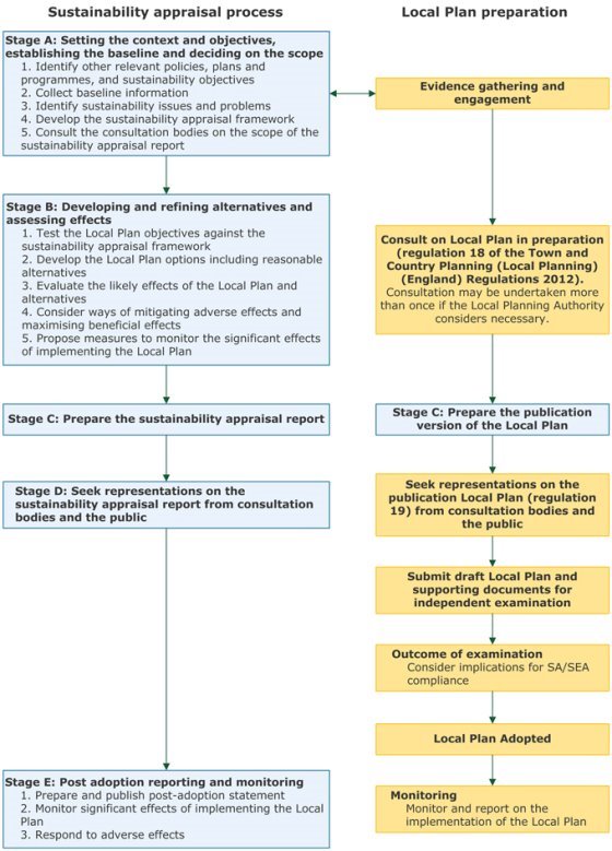
1.3 National Planning Practice Guidance sets out the key stages and tasks for the SA process and their relationship with the Local Plan process – as illustrated in the following Figure 1.1. These key stages and tasks are applicable to the SA process for the Warwick Canalside DPD. It is important to note that SA is an iterative and on-going process. Stages and tasks in the SA process may be revisited and updated or revised as a plan develops, to take account of updated or new evidence as well as consultation responses. The role of the SA is to inform the plan-making process.
1.4 This SA Report explains the Stage A Scoping that was completed earlier and sent to the statutory consultation bodies in accordance with good practice. It reports the findings of Stage B Alternatives & Assessment and comprises Stage C Preparation of the SA Report. This SA Report accompanies the Warwick Canalside DPD on public consultation for Stage D and seeks comments from the public and the statutory consultees.
Figure 1.1: SA and Plan-making Stages and Tasks
The Warwick Local Plan 2011-2029
1.5 The overarching development plan document (DPD) for the Warwick District area is the Local Plan that was adopted in September 2017[9]. The Local Plan set out a commitment[10] to draft two DPDs for the District: Gypsy & Traveller DPD and Canal DPD. The Canal DPD will identify a new Conservation Area(s), consider how the canalside can be improved in relation to opportunity sites for new/redevelopment in the urban sections and consider issues around the canal environment throughout the district. Issues around improving access to the canals and encouraging new users will also be examined. The Council has also published a Supplementary Planning Document (January 2019)[11] to update the situation with regard to air quality and reflect the increasing concern about air quality and climate change. The Local Plan DPDs, SPD and Neighbourhood Plans comprise the hierarchy of planning documents that, together with the NPPF, guide applications and decisions for new development in the Warwick District area.
The Warwick Canalside Development Planning Document (DPD)
1.6 The Canalside DPD has been prepared in accordance with the policy requirement in the Local Plan (2011-2029). Policy DS17 states:
"The Council will prepare and adopt a Canalside Development Plan Document (DPD) to:
a) assess the canals in the District and their environment and setting;4
b) identify areas for regeneration along urban sections, particularly for employment, housing, tourism and cultural uses; and
c) identify areas for protection, where these are appropriate, throughout the canal network within the District.
This document will designate particular areas and uses and will set out policies for use in assessing planning applications."
1.7 The canalside has been given special consideration as it is considered that this area has long been neglected in terms of development and public use and that there are opportunities in this area that could be exploited for both the local and wider community. The draft Canalside DPD comprises the following:
- Objectives of the DPD
- Policy Background
- The New Conservation Area
- Context of canals in Warwick District - Grand Union Canal, The Stratford upon Avon and Birmingham and Fazeley Canals
- Issues - rubbish dumping, crime & perception of crime, vandalism, aesthetics, HS2, vacant & underused buildings, access, flooding
- Potential Options
- Opportunity Sites
- Policies: CS1 Design; CS2 Parking; CS3 Archaeology; CS4 Biodiversity; CS5 Renewable Energy; CS6 PBSA; CS7 Signage; site-specific - CS9 Sydenham Industrial Estate; CS10 Industrial Estate Millers Road/Cape Road; CS11 former school at Montague Road
- Who will be involved?
- Appendix I Other Opportunity Sites Analysed
- Appendix II Listed Buildings close to the Canals
- Appendix III Constraints (Local Nature serves; Local Wildlife Sites; HP gas pipelines; HV overhead power lines; minerals; Conservation Areas; historic landfill & contaminated land; HS2 safeguarding)
1.8 The Objectives of the Canalside DPD are as follows:
- Identify issues and opportunities and address/exploit them
- Look at a wide range of potential schemes to encourage more use of the canals and be imaginative and creative
- Increase the use of the canals and their environs to open them up to a new range of activities
- Create new frontages to face the canals instead of backing onto them, especially with new residential development
- Change perceptions of hidden backwaters as dangerous and crime ridden
- Make the canals safe and attractive and accessible to everyone
- Improve the visual aspects of the canals and widen their appeal to include all sectors of the community
- Protect any aspect of the canal that needs to be preserved whether tangible or conceptual
- Protect wildlife, habitats and water quality
- Increase awareness by use of directional and information boards in appropriate location
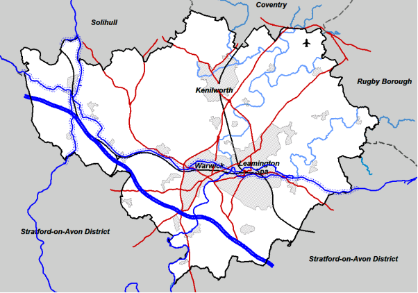
1.9 The DPD covers the whole length of all sections of canal that run through the district. It considers the canals themselves and the land to either side, the state of the towpaths and any facilities that are provided and the land beyond where there is vacant or under-utilised land and/or buildings or other opportunities for regeneration. It also considers the existing communities, both on the canals and alongside. The extent of the waterways, canals and the canalsides in the Warwick District area is shown in the map[12] following:
Figure 1.2: Location of Canals in Warwick District
Consultation
1.10 The statutory consultation bodies were consulted upon the SA/SEA & HRA scoping and screening report (September 2019). The Warwick District Council is publishing the draft Canalside DPD together with this SA Report for statutory and wider public consultation. Any comments on the draft DPD and SA will be taken into account.
Compliance with the Requirements of the EU SEA Directive
1.11 The Strategic Environmental Assessment Regulations set out certain requirements for reporting the SEA process and specify that, if an integrated appraisal is undertaken (i.e. SEA is subsumed within the SA process), then the sections of the SA Report that meet the requirements set out for reporting the SEA process must be clearly signposted. This SA Report presents the SA/SEA testing of the emerging Development Plan Document and includes a Non-Technical Summary and an appendix that clearly signposts the requirements for reporting the SEA.
This SA Report
1.10 The Warwick Local Plan was subject to SA/SEA (Submission Report 2015 & Addendum 2017)[13] and HRA (Screening Report 2014) during its preparation and examination, including formal and public consultation. The Canalside DPD must be in conformity with the adopted Local Plan and it is important that the SA/SEA is also in conformity with the previous assessments. However, the NPPF was revised in 2018, including significant implications for biodiversity net gain. This SA seeks to incorporate the updated requirements, including the information set out in planning practice guidance.
1.11 A Court of Justice of the European Union (CJEU) Judgment (2017)[14] has had implications for the established methods in the UK for undertaking HRA (and through which the Local Plan had been assessed). The implication of this judgment is that competent authorities cannot take account of any integrated or additional avoidance or reduction measures when considering at the Habitats Regulations Assessment (HRA) screening stage whether a plan is likely to have an adverse effect on a European Site. Therefore, this report seeks to update the assessment process and make explicit that the initial stage of HRA screening has been applied without consideration of embedded mitigation such as through Local Plan policies.
1.12 This report has been prepared in accordance with regulatory requirements, government guidance and in consideration of good practice. A proportionate approach has been taken since the Local Plan was adopted in 2017 and the DPD focuses on the canals with their canalsides through the District. The HRA considerations have been addressed within this SA Report. Warwick District Council has commissioned independent SA/SEA & HRA specialists Enfusion Ltd to undertake the work on behalf of the Council.
1.13 Section 2 of this SA Report describes the approach taken and methods used with the baseline characterisation presented in Section 3. The approach to options in plan-making and reasonable alternatives in SA/SEA is explained in Section 4. The findings of the SA and HRA assessments are presented in Section 5. An outline of the approach for monitoring is set out in Section 6 and conclusions with next steps outlined in Section 7.
[1] EU Directive 2001/42/EC
[2] Environmental Assessment of Plans and Programmes Regulations, 2004 http://www.legislation.gov.uk/uksi/2004/1633/contents/made
[3] Section 19(5) of the 2004 Planning & Compulsory Purchase Act and Regulation 22(a) of the Town & Country Planning (Local Planning) (England) Regulations 2012
[8] Support internationally important wetland habitats and are listed under the Ramsar Convention on Wetlands of International Importance
[12] From the emerging draft Warwick District Canalside DPD
[14] People over Wind & Sweetman v Coillte Teoranta Case C-323/17